Hasta la Vista from La Ferte Loupiere

This route was brought to you by:
RouteXpert Jan Koelstra (jan cabrio)
Last edit: 29-01-2025
 Route Summary
 Routes under this umbrella have in common that they all come closer to the Spanish sun, where along the way you will be reunited with (almost) forgotten impressions and memories.
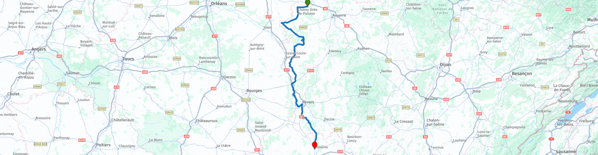
This time the trip goes from La Ferté-Loupière to Moulins.
Afterwards you will have refreshed your memory and also discovered that France is so damn beautiful. And that is certainly worth 5 stars.
 Share this route


Animation

Verdict


Duration
7h 44m

Mode of travel
Car or motorcycle

Distance
237.21 km

Countries

 RouteXpert Review
 This ride goes from La Ferté-Loupière in the Puisaye region to Moulins.
The most beautiful sight in La Fertë is the mural Danse Macabre in the local church. To fully understand the nuances of the murals, it is essential to learn about the production of ochre in Puisaye. This land was the cradle of ochre mining and provided the pigments that provided work for countless workers and artists with their artistic masterpieces. The subtle use of these pigments in church murals adds a unique dimension to these architectural gems. In Puisaye, there are around 15 churches with murals from the 12th century. You will pass some that you can also visit, such as the one in Moutiers-en-Puisaye. The church displays Romanesque architecture with a 13th-century portal and numerous medieval murals covering 200 square metres. Founded in the 10th century as part of an 8th-century monastery, the church served as a stopover for pilgrims on their way to the tomb of St. Peter in Rome.
After refuelling in the neighbouring village of Charny, continue to Rogny-les-Sept-Écluses. The addition of the 'seven locks' shows why Rogny was put on the map. It is the main tourist attraction of the village. Every year, they attract thousands of visitors, who come to admire this gigantic work of art, designed by Henri IV and the Duke of Sully in 1597. King Henri IV dreamed of connecting the Mediterranean to the Ocean and the English Channel by joining the rivers Loire and Seine via a canal. Between these two rivers, the problem was to cross the hill at Rogny. on the Loing valley. For every problem, there is a solution. Hydraulic engineer Hugues Cosnier then created a series of locks to challenge this height difference of 24 metres, composed precisely of 6 locks, later connected by a seventh. Each lock was 28 m long and 4.80 m wide.
The exploitation of the forests made it possible to install kilns in St-Fargeau, the main town of the Puisaye, to process the ochre ore extracted from the ferruginous soil. The impressive Château de St-Fargeau is surrounded by a moat and has massive towers at the entrance and on the corners. The light pink bricks soften the austere appearance of the castle somewhat. All but the largest tower have slender, openwork lanterns. The spacious courtyard with five wings forms a rare elegant whole.
For almost 30 years, Guedelon has been working on a unique project: the construction of a castle, using techniques from the 13th century. An enormous medieval construction pit where some fifty craftsmen worked. A special dive into history! Here, a castle has been formed stone by stone, right before your eyes. A spectacle that continues to develop and a wonderful way to get acquainted with history, architecture, calculations and geometry. In 1997, this insane project was started: the construction of a medieval castle, using techniques from the 13th century. The goal? To experience and understand what it was like in the Middle Ages. Since then, stonemasons, masons, woodcutters and blacksmiths have been working hard here. And all of this under the watchful eye of some 300,000 visitors who come here every year!
You take the road back a little to Treigny for another castle, one of the most majestic historical ones in the region. The impressive façade of the Château de Ratilly stands in the middle of the village, a real medieval fortress, in the heart of an intact countryside. After several embellishments during the Renaissance, it now houses, around a peaceful courtyard, a craft pottery and an art centre. The defensive towers, the central courtyard and the dovecote make Ratilly an emblematic building in France.
You leave the Puysaye region at the town of Saint-Amand-en-Puisaye. This is the pottery town at its best: every place in the municipality of Saint-Amand-en-Puisaye has a connection or memory with ceramics through exhibitions and guided tours. The sandstone castle-museum of Saint-Amand-en-Puisaye was built between 1530 and 1540, in the middle of the Renaissance. It was once a feudal fortress. The collection is mainly decorative, useful or artistic ceramics from the 18th century to the present day.
On the way to the magnificent monastery at L:a Charité, you will pass Saint-Laurent-l'Abbaye, where the 11th century abbey welcomed pilgrims to Santiago de Compostela. The Augustinians lived there and had many properties in the area. The abbey, now in ruins, was damaged during the Wars of Religion and the last inhabitants left shortly before the French Revolution.
The medieval town of La Charité-sur-Loire, situated on the Loire and surrounded by ramparts, is best known for its priory. The Benedictine monastery, founded in 1059, is listed as a UNESCO World Heritage Site together with the priory of the Order of Cluny as a "stage on the route to Compostella" and is a remarkable example of Burgundian Romanesque art. From the island in the middle of the Loire (L'Ile de Faubourg) you have a beautiful view of the medieval town. The lower town with its old houses and narrow alleys has hardly changed for centuries. The streets with names such as Rue des Mariniers, Rue du Pont and Place des Pêcheurs indicate that this was once the residential area of the fishermen. The winegrowers had built their houses a little higher up on the bank. Part of the old ramparts has been preserved and there are ongoing projects to further renovate them. The northern part of the ramparts offers a beautiful view of La Charité-sur-Loire, the Loire and the surrounding area.
Nevers is nearby. Your next place where a drink is waiting for you. The historic center still breathes the atmosphere of times gone by, with cobbled streets, old half-timbered houses and impressive churches. Nevers is also known for its pottery production and has a lively cultural life with many festivals and events. The Nevers tourist office has made it easy for us as visitors to discover the city on foot. A “fil bleu” (a blue line) runs through the city. If you follow this line along the sidewalk, you will pass many (historical) sights.
A nice excursion on the way to the finish is to try out the Circuit Nevers at Magny-Cours.
It hosted the Formula 1 Grand Prix from 1991 to 2008. In other words, several world champions have tackled corners like Estoril and Adélaïde. Will you be next? The Magny-Cours track is 4411 metres long and is both technical, fast and very complete. The ideal circuit to host the Fun Cup at the end of May!
A museum presents the history of motorsports on 1,400 m². The establishment consists of a "corridor of time", an exhibition space for builders and an amphitheatre. Visitors can admire no less than 15 Formula 1 cars such as the Renault RE30B driven by Alain Prost in 1982 and the Martini MK23 of René Arnoux from 1978. Also on display is the Gordini T15 from 1948 driven by Jean-Pierre Wimille, Maurice Trintignant and Juan-Manuel Fangio. A collection of Ligier F1 from 1976 to 1996 is also visible.
You will end this trip in Moulins, a beautiful historic city in the north of Allier. The city was founded in the Middle Ages and you can find the most beautiful historical sights and old half-timbered houses there. When you are strolling through Moulins, you imagine yourself in the Middle Ages. The city used to be inhabited by the Dukes of Bourbon and they brought a lot of wealth to the city. One of the highlights is the Notre-Dame-de-l'Annonciation. The church has a Gothic architectural style and you can find impressive stained glass windows. You should also definitely take a look at the triptych of the Master of Moulins. The Place de L'Ancien-Palais is also highly recommended. This square is always pleasantly busy and is surrounded by medieval half-timbered houses. You can enjoy all kinds of nice restaurants and terraces there. On the Place d'Allier, the large square of Moulins, with the Grand Café you will find a Bar-Brasserie, which is one of the most beautiful in France. It is listed as a monument because the interior and the decoration in Belle-Époque style from 1899 have been preserved. Maybe you will stay there for a while with a drink...


 Links
Links  Usage
Usage Want to download this route?
You can download the route for free without MyRoute-app account. To do so, open the route and click 'save as'. Want to edit this route?
No problem, start by opening the route. Follow the tutorial and create your personal MyRoute-app account. After registration, your trial starts automatically.  Disclaimer
Use of this GPS route is at your own expense and risk. The route has been carefully composed and checked by a MyRoute-app accredited RouteXpert for use on TomTom, Garmin and MyRoute-app Navigation.
Changes may nevertheless have occurred due to changed circumstances, road diversions or seasonal closures. We therefore recommend checking each route before use.
Preferably use the route track in your navigation system. More information about the use of MyRoute-app can be found on the website under 'Community' or 'Academy'.

Auvergne Rhone Alpes
About this region
Auvergne-Rhône-Alpes (ARA; French: [ovɛʁɲ ʁon‿alp] (listen); Arpitan: Ôvèrgne-Rôno-Ârpes; Occitan: Auvèrnhe Ròse Aups; Italian: Alvernia-Rodano-Alpi) is a region in southeast-central France created by the 2014 territorial reform of French regions; it resulted from the merger of Auvergne and Rhône-Alpes. The new region came into effect on 1 January 2016, after the regional elections in December 2015.The region covers an area of 69,711 km2 (26,916 sq mi), making it the third largest in metropolitan France; it had a population of 7,948,287 in 2017, second to Île-de-France. It consists of twelve departments and one territorial collectivity (Lyon Metropolis) with Lyon as the prefecture.
This new region combines diverse geographical, sociological, economic and cultural regions, which was already true of Rhône-Alpes, as well as Auvergne, to a lesser extent. While the old Rhône-Alpes and Auvergne regions each enjoyed a unity defined by axes of communication and the pull of their respective metropoles, the new combination is heterogeneous; it sustained lively opposition from some local officials after its creation.
Read more on Wikipedia
This new region combines diverse geographical, sociological, economic and cultural regions, which was already true of Rhône-Alpes, as well as Auvergne, to a lesser extent. While the old Rhône-Alpes and Auvergne regions each enjoyed a unity defined by axes of communication and the pull of their respective metropoles, the new combination is heterogeneous; it sustained lively opposition from some local officials after its creation.
View region
 Statistics
  118
118Amount of RX reviews (Auvergne Rhone Alpes)
 45086
45086Amount of visitors (Auvergne Rhone Alpes)
 5427
5427Amount of downloads (Auvergne Rhone Alpes)
 Route Collections in this region
 The 24 Most Beautiful Alpine Routes
The Alps, The Alps are a mountain range in Europe, stretching from the French Mediterranean coast in the southwest to the Pannonian Plain in the east. The area of the mountain range is more than 200,000 km².
In other words Passes and Mountain Roads!
Driving through the mountains is great! Especially over the mountain passes with hairpin bends and narrow winding roads. Every bend a different view where you can enjoy. There are many beautiful mountain passes in the Alps.
A selection that has also been incorporated into these routes:
The Stlevio Pass:
The Stelvio Pass, also known as Passo dello Stelvio, is mainly known for the stage in the Giro d'Italia. Due to the length and the difference in height, this pass is seen as one of the toughest tests in cycling. The Stelvio Pass reaches a maximum height of 2758 meters and is therefore one of the highest in the Alps. The pass connects the towns of Bormio and Prato Allo Stelvio. In winter the pass is closed due to heavy snowfall.
The Reschenpass:
The Reschenpass, also known as Passo di Resia, connects the Austrian state of Tyrol with the Italian province of South Tyrol. The pass reaches a maximum height of 1,504 meters and has been one of the most important north-south connections in the Alps in recent centuries. The pass was used long before Roman times. Along the way you will pass several highlights and historical relics. One of the highlights is the Reschensee. This lake was created after the construction of the dam and has completely submerged the village of Graun. The only thing that reminds of that is the clock tower in the middle of the lake.
Col du Galibier:
The French mountain pass Col du Galibier connects the towns of Saint-Michel-de-Maurienne and Briançon via the Col du Lautaret in the south and the Col du Télégraphe in the north. The mountain pass is part of the Tour de France and very much feared, due to the fact that it can only be reached via the other two mountain passes. The pass reaches a maximum height of 2646 meters. From there you can take a walk to the viewpoint at 2704 meters. You can admire the peaks of the Grand Galibier, Mont Blanc and La Meije here.
The Grossglockner High Alpine Road:
With a height of 3798 meters the Grossglockner is the highest mountain in Austria. To fully enjoy this impressive mountain, you can drive over the Grossglockner High Alpine Road and the accompanying pass. The route starts from Bruck am Grossglockner and ends in Heiligenblut. Of course you can drive in two directions. The pass reaches a maximum height of 2504 meters and is closed in winter due to heavy snowfall. Along the way you pass several stops with fun activities, information points, mountain huts and viewpoints. A visit to the Kaiser-Franz-Josefs-Höhe and Pasterzen Glacier is highly recommended.
The Col d'Izoard:
Just like the Col du Galibier, the Col d'Izoard is also part of a stage of the Tour de France. The mountain pass connects Briançon with the valley of the river Guil. The pass is partly located in the Regional Natural Park du Queyras and reaches a maximum height of 2360 meters. What is special about the Col d'Izoard is the barren and rocky landscape. Sometimes it feels like driving a car over the moon! Along the way you can stop at several points to enjoy the beautiful view.
The Bernina Pass:
The Bernina Express is one of the most famous rail trains in Switzerland and the Alps. The route is beautiful and partly included on the UNESCO World Heritage List. Parallel to the railway lies the Bernina pass, which connects the Veltlin valley with the Egandin valley. This beautiful Alpine road has a total length of 56 kilometers and reaches a maximum height of 2328 meters. Along the way you can enjoy views of the Morteratsch Glacier.
The Sella Pass:
The Sella Pass, also known as Passo di Sella, takes you over one of the most impressive mountain ranges in the Dolomites: the Sella massif. The pass connects Valle di Fassa with Val Gardena and reaches a maximum height of 2236 meters. At this height is also the border of the Italian provinces of Trentino and Bolzano. Along the way you can enjoy the view of this spectacular mountain world. Admire, for example, the three peaks of the Sasso Lungo massif, the Sella massif or the peaks of the Marmolada. You can also drive the Sella pass in combination with the Gardena pass, Pordoi pass and Campolongo pass.
The Grimsel Pass:
The Grimsel Pass connects Goms in Wallis with the Halis Valley in the Bernese Oberland. The pass reaches a maximum elevation of 2165 meters and is closed in winter due to snowfall. Over the centuries, the mountain pass has played an important role in trade between Switzerland and Italy. Now it is mainly the reservoirs that have an important function. These are used to generate electricity. The landscape you drive through is rugged, rocky and impressive. On top of the pass is a hotel and a restaurant with a special marmot park. The Dodensee (Totensee) is also located here. This lake owes its name to the many soldiers who died in the time of Napoleon.
The Gotthard Pass:
The Gotthard Pass, also known as Passo del San Gottardo and Saint Gotthard, connects the Swiss towns of Airolo and Andermatt. The mountain pass and associated tunnel are especially known among holidaymakers driving from Switzerland to Italy. But where the majority opt for the tunnel, it is precisely the pass that really completes the holiday. The Gotthard Pass has a length of about 26 kilometers and reaches a maximum height of 2106 meters. The route is beautiful and takes you along old villages and beautiful views.
The Silvretta High Alpine Road and Silvretta Pass:
The Paznaun Valley in Tyrol and the Montafon in Vorarlberg are connected by the Silvretta High Alpine Road. The route has a length of 22.3 kilometers and leads from Galtür to Partenen in 34 hairpin bends, via the 2032 meter high Bielerhöhe. The Silvrettasee is also located at this point, where you can enjoy a lovely walk. The pass is closed in winter due to snowfall.
The Simplon Pass:
Just like the Gotthard Pass, many holidaymakers also travel over the Simplon Pass every year. This mountain pass connects the Rhone Valley in the canton of Valais with the Valle d'Ossola in Piemonte. The pass is open all year round and reaches a maximum height of 2005 meters. Along the way you pass a number of buildings, including the well-known Simplon Hospiz from 1825. The hospiz is managed by the monks of St. Bernard. From the highest point on the pass, all kinds of hiking routes are possible and you will also come across a hotel where you can spend the night.
The Gerlos Pass:
The Gerlos Pass connects the Salzach Valley in the Salzburgerland with the Zillertal Valley in Tyrol. The pass is part of the Gerlos Alpenstraße and runs right through the Hohe Tauern National Park. Along the way you can enjoy beautiful views of the surroundings. The pass has a length of 12 kilometers and reaches a maximum height of 1531 meters. A ride over the Gerlos Pass can be ideally combined with a visit to the Krimmler Wasserfälle.
The Great St. Bernard Pass:
The Great St. Bernard Pass, better known as Col du Grand Saint Bernard, connects the Italian province of Valle d'Aosta with the Swiss canton of Valais. The pass is one of the highest in Switzerland and reaches a maximum height of 2469 meters. Like a number of other mountain passes in this list, the Great St. Bernard Pass has also been used as a connecting road for centuries. The pass is named after the St. Bernard dogs that used to help stranded travelers along with the monks. The pass is closed in winter.
The Timmelsjoch High Alpine Road:
The Timmelsjoch High Alpine Road connects the towns of Sölden in the Ötztal and Meran in South Tyrol. Tolls must be paid on the Hochgurgl - Moos route. Via a mountain road with about 60 hairpin bends you drive through a beautiful mountain world. With the Timmelsjoch Experience you can learn more about the history, the road and the environment via various stations. You can also visit the Top Mountain Crosspoint museum.
Col de l'Iseran:
With a maximum pass height of 2770 meters, the Col l'Iséran is one of the highest mountain passes in the Alps. The pass connects Bourg-Saint-Maurice with Bonneval-sur-Arc. Via a road full of hairpin bends you pass, among other things, Val-d'Isère and a side valley of the Maurienne that lies entirely in the National Park de la Vanoise. You can spot animals such as marmots and chamois and there is also a restaurant with a chapel on top of the pass.
The Gavia Pass:
The Gavia Pass (Italian Passo di Gavia) is a mountain pass in the Italian Alps, in the Lombardy region.
It is one of the highest pass roads in Europe. The road leads through the unspoilt Stelvio National Park. The road was built in the First World War to supply Italian soldiers who fought in the Italian-Austrian border area. The pass height is one of the most beautiful in the Alps. Here is the large Lago Bianco with, to the north, the mountain San Matteo (3684 meters). Lago Nero is slightly lower on the south side of the pass. Here the mountain group of the Adamello determines the view. There are many well-marked walks in the area. During the winter the pass is closed due to the heavy snowfall. The pass is often closed until May and June due to the large amount of snow.
Promoter has made a selection of the 24 Most Beautiful Alpine routes that they have set out in recent years.
The routes go through:
France
Austria
Switzerland
Italy
The most beautiful roads, the most beautiful views, the most beautiful viewpoints. The highest mountains, the fastest descents, hairpin bend after hairpin bend, you name it you can't get enough of it.
If you go on holiday in this region, take advantage of it, ALL routes in this collection have been checked and made equal for TomTom, Garmin and MyRoute-app Navigation by a MyRoute-app RouteXpert.
Have fun with this collection and while driving one of these routes. Enjoy all the beauty that the Alps and the Dolomites have to offer. Click on “View route” to read the review of the chosen route.
I would like to hear your findings about the route(s).
View Route Collection
25 Magnificent trails in France
This MRA route collection contains 25 beautiful motorcycle routes in different parts of France, such as the Ardennes, the Alsace, Vercors, the Drôme, the Ardèche, Cote d'Azure, Gorges du Verdon, the Ariège, the Dordogne and Brittany.
The routes have been carefully created by Bert Loorbach, who is an enthusiastic motorcyclist himself. He lived in France for a year and a half, during which time he devoted himself to mapping the unknown and beautiful back roads of France especially for motorcyclists.
The routes are bundled in the Motortourgids France part 1 of Kosmos publishing house and now also available in MyRouteApp.
I have taken over the routes in MRA and sometimes adjusted them slightly to make them even more interesting for the motorcyclist.
View Route Collection