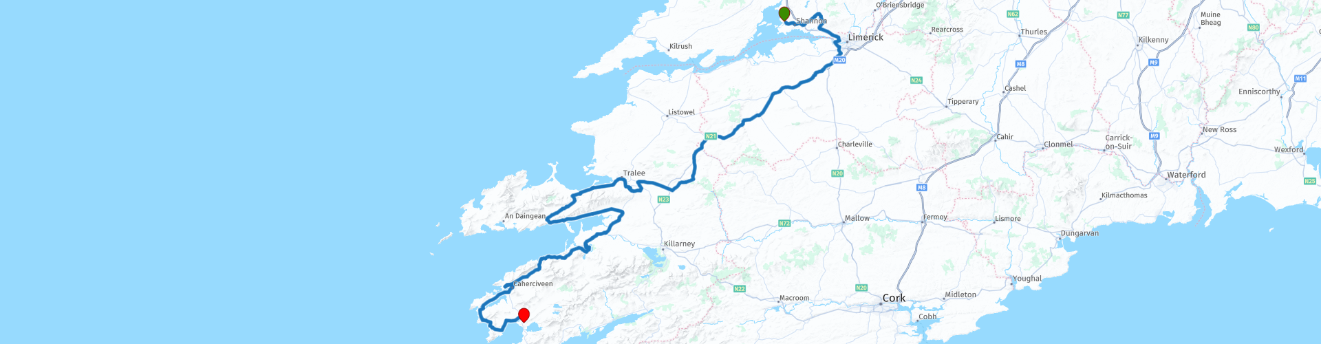
05 van Shannon naar Waterville via de Kerry Cliffs

This route was brought to you by:
RouteXpert Hans Lamers - RouteXpert
Last edit: 29-01-2025
 Route Summary
 But be careful! The roads are generally good, but some rural areas can be narrow and winding. Be prepared for changing weather conditions, especially in mountainous areas.
Make sure you fill up regularly, especially in more rural areas where gas stations can be scarce.
5 stars for this route is well deserved in my opinion.
This route is the same for TT, Garmin, openstreet maps and MyRoute-App Navigation.
 Share this route


Animation

Verdict


Duration
8h 51m

Mode of travel
Car or motorcycle

Distance
304.38 km

Countries

 RouteXpert Review
 Via Sixmilebridge, Rathkeale, Castleisland, Lough Caragh, Cahersiveen and the Kerry Cliffs
The morning in Shannon can start fresh and promising. As you start your engine, you can feel the excitement of a day of adventure.
Today's route takes you along the most beautiful parts of Ireland's Wild Atlantic Way, through picturesque villages, past glittering lakes and impressive cliffs. You know this ride is going to be one of the most memorable.
The first few miles take you to Sixmilebridge, a charming village on the edge of County Clare. The road there is quiet, surrounded by green fields and small farms. A short distance further you pass the small village of Cratloe in County Clare and on your left Cratloe Wood, a state forest on the slopes of Woodcock Hill. It is believed that the beams of the roof in Westminster Hall came from Cratloe Wood.
Cratloe Wood, takes its name from the Irish for 'Land of Sallow Trees'. Next to the small village of Cratloe lies Cratloe Woods, originally oak forests from prehistoric times. In the ninth century this was a McNamara area and was invaded by warriors from the kingdom of Aileach in Ulster. These men took timber from Cratloe to build the roof of the royal palace of Aileach in Ulster.
There are pleasant woodland walks, a playground and picnic tables for a relaxing day out with the family.
Then you follow the N18 and N21 towards Rathkeale, a town deeply rooted in Irish history. The roads become wider and the landscape opens up to vast meadows. In Rathkeale you notice the peace of the countryside, with old buildings and friendly locals. Your engine hums contentedly on the N21 and when you have passed the town of Abbeyfeale you can stop at a petrol station. Here you can have a cup of coffee in the shop next to the petrol station or stretch your legs.
After about 20 kilometres of beautiful back roads you will pass through Castleisland, a town often referred to as the gateway to County Kerry. The road starts to get more winding, and the mountains in the distance are getting closer. The High Street is lively, with cosy shops and pubs. You feel the energy of Kerry and know that the best part of your journey is yet to come.
Via the towns of Tralee and Blennerville you will pass the Tralee Nature Reserve, also known as the Tralee Bay Wetlands Eco & Activity Park, which is located in Tralee, County Kerry, on the canal and at the mouth of Tralee Bay. This beautiful nature reserve offers wonderful lakeside walks and wild gardens for all to enjoy.
This natural landscape, with its special nature reserves, will enrich your holiday and you will look at the world around you with greater awe and appreciation. Whether it is the simplicity and beauty of the cry of the Curlew or the lifelong love affair of swans, you will be captivated.
After about 30 kilometers it is possible to have a bite to eat. On the right side there is a nice restaurant, “Sammy's”. You can have a nice meal or a quick bite to eat and then continue the route.
The R561 takes you via the towns of Milltown and Killorglin past Lough Caragh. A Mirror of Tranquility From Castleisland the road turns into the Ring of Kerry, one of Ireland's most beautiful routes. You reach Lough Caragh, an enchanting lake surrounded by mountains and forests. The water is so still that it seems as if the sky and mountains are reflected in it.
You can stop here on the side of the road and breathe in the fresh air. This is why you drive: the peace, the nature and the sense of freedom that only the open road can provide.
You decide to take a short detour to the remains of Ballycarbery Castle, a ruined castle overlooking the sea. It is a magical place, where time seems to stand still.
The route takes you further to Cahersiveen, also known as the Soul of Kerry. It is a lively town with a rich history. Along the way you pass rolling hills and narrow roads with stone walls. Cahersiveen feels like a mix of old and new, with its historic sights and modern cafes.
Via Valentia Island you follow the road to the Kerry Cliffs, one of the highlights of the Wild Atlantic Way. The road becomes narrower and more challenging, with sharp bends and steep inclines, but the views make it all worthwhile.
At the Kerry Cliffs, park your bike and walk to the lookout. The cliffs rise high above the Atlantic Ocean, with waves crashing against the rocks far below. The wind blows hard, and you can feel the power of nature in every breath.
This moment is unforgettable.
The last few kilometres take you to Waterville, a charming seaside village loved by Charlie Chaplin. As the sun slowly sinks into the ocean, you drive through the village and feel the relaxed atmosphere.
You park your bike at a small pub on the waterfront and order a well-earned meal. With a pint of Guinness in hand, you look out over the ocean, while you think back on the highlights of the day. This ride was more than a trip from A to B; it was a journey through the heart of Ireland, full of nature, history and freedom.


 Links
Links  Usage
Usage Want to download this route?
You can download the route for free without MyRoute-app account. To do so, open the route and click 'save as'. Want to edit this route?
No problem, start by opening the route. Follow the tutorial and create your personal MyRoute-app account. After registration, your trial starts automatically.  Disclaimer
Use of this GPS route is at your own expense and risk. The route has been carefully composed and checked by a MyRoute-app accredited RouteXpert for use on TomTom, Garmin and MyRoute-app Navigation.
Changes may nevertheless have occurred due to changed circumstances, road diversions or seasonal closures. We therefore recommend checking each route before use.
Preferably use the route track in your navigation system. More information about the use of MyRoute-app can be found on the website under 'Community' or 'Academy'.

Munster
About this region
Munster (Irish: an Mhumhain [ə ˈwuːnʲ] or Cúige Mumhan [ˌkuːɟə ˈmˠuːnˠ]) is one of the provinces of Ireland, in the south of Ireland. In early Ireland, the Kingdom of Munster was one of the kingdoms of Gaelic Ireland ruled by a "king of over-kings" (Irish: rí ruirech). Following the Norman invasion of Ireland, the ancient kingdoms were shired into counties for administrative and judicial purposes. In later centuries, local government legislation has seen further sub-division of the historic counties.
Munster has no official function for local government purposes. For the purposes of the ISO, the province is listed as one of the provincial sub-divisions of the State (ISO 3166-2:IE) and coded as "IE-M". Geographically, Munster covers a total area of 24,675 km2 (9,527 sq mi) and has a population of 1,280,020, with the most populated city being Cork. Other significant urban centres in the province include Limerick and Waterford.
Read more on Wikipedia
Munster has no official function for local government purposes. For the purposes of the ISO, the province is listed as one of the provincial sub-divisions of the State (ISO 3166-2:IE) and coded as "IE-M". Geographically, Munster covers a total area of 24,675 km2 (9,527 sq mi) and has a population of 1,280,020, with the most populated city being Cork. Other significant urban centres in the province include Limerick and Waterford.
View region
 Statistics
  13
13Amount of RX reviews (Munster)
 17336
17336Amount of visitors (Munster)
 1377
1377Amount of downloads (Munster)
 Route Collections in this region
 Complete tour of Ireland
Ireland is a beautiful country to drive. This collection contains 10 connecting routes that take you past the most beautiful, cities, villages, sights and wonders of nature.
All routes include reviews, route points for hotels, restaurants and POI.
The Irish population is very friendly and hospitable, in every village there are several pubs and restaurants where you can enjoy Irish cuisine.
There are several (historical) sights included in the routes, here is a summary overview per route, in the reviews of the routes you will find more details.
IRL1; Belvedere House & Garden Parks, Charleville Castle and the Ruins of Clonmacnoise
IRL2; Sky Road, Connemara Natural Park and Kylemoore Abbey.
IRL3; The Burren, the peninsulas Lettermore, Tiermee and Teach Mor, Blackhead and the Cliffs of Moher.
IRL4; Bunratty Castle, Folk Park and King Johns Castle.
IRL5; Ring of Kerry and Skellig Ring, this is without a doubt the most beautiful part of the Ring of Kerry. With a beautiful view of Little Skellig and Skellig Michael, the islands where the latest Star Wars film was shot.
IRL6; Ring of Beare, Glenngariff Woods Nature Reserve and one of the most beautiful panoramas in Ireland: "Ladies View".
IRL7; Killarney National Park with Molls Gap, Ladies View, the Healy Pass and Priest's Leap (very narrow winding route with partly very bad road surface) and Mizen Head.
IRL8; Blarney Castle, Cahir Castle, Killkenny Castle and Saint Canice's Cathedral.
IRL9; Dunmore Caves, SS Dunbrody Irish Emigrants ship, the ruins of Dunbrody Abbey and Garden and Kilkenny Castle.
IRL10; the ruins of the Black Castle, The Altamont Gardens, Powerscourt Gardens and Waterfall and St. Patricks Cathedral.
The routes are mainly country roads, often with beautiful curves, but sometimes very narrow or of poor quality. Driving experience is required, partly because of driving on the left side of the road.
You drive through nature parks and pass such as the Healy Pass, Conner Pass, Priest's Leap and Molls Gap. Two beautiful routes are the famous Ring of Kerry (IRL5) and Ring of Beare (IRL6). These are long journeys with many beautiful things along the way, so staying overnight while on the road is highly recommended. It can also be very busy on these routes in the weekends.
The other two routes in this collection is The Wild Atlantic Way from North-South and from South to North. This route is a sensational journey past towering cliffs and lively villages and towns, past hidden beaches and beautiful bays. This route follows the West Coast and you do multiple places from the other routes. The review of the route contains more details and for even more information I refer to https://www.wildatlanticway.com/home
All routes in this collection are all beautiful and challenging and can be driven by car or motorcycle.
Have fun with these routes.
View Route Collection
7 Beautiful Routes Through Ireland
"7 beautiful routes through Ireland"
You may have seen one of these routes before. There are seven routes driven and created in 2024. The routes are part of a 7-day trip through Ireland. You drive through landscapes that are very diverse. Especially the roads along the coast are breathtaking.
The roads are from reasonable to good, but you also drive on roads that are less maintained and there can be some gravel on the roads here and there. Also, grass often grows in the middle of the roads, so caution is required.
These are generally beautiful routes through a beautiful country. The routes are connecting and go along the west coast. The route starts in Belfast and ends in Rosslare.
The collection contains the following routes:
Day 1 Belfast to Carrick on Shannon via Enniskillen Castle (265 Km)
Day 2 from Carrick on Shannon to Cleggan towards the Wild Atlantic Way (216 Km)
Day 3 from Cleggan to Shannon via The Cliffs of Moher (254 Km)
Day 4 from Shannon to Waterville via the Kerry Cliffs (304 Km)
Day 5 Waterville to Inchigeelagh via Dursey Island Cableway (256 Km)
Day 6 of Inchigeelagh via Mizen Head Tour (214 Km)
Day 7 Inchigeelagh to Rosslare via Hookhead Lighthouse (307 Km)
All routes have been checked and made equal for Tomtom, Garmin, open streetmaps and MyRoute-App Navigation. The routes follow the original route as it was made at the time.
Have fun driving one of these routes. Enjoy all the beauty that Ireland has to offer.
View Route Collection