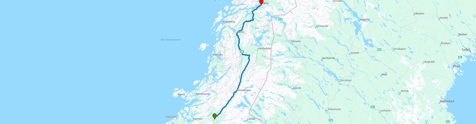
R07 Grong to Mo i Rana

This route was brought to you by:
RouteXpert Arno van Lochem - Senior RX
Last edit: 20-05-2021
 Route Summary
 The routes are easy for everyone to ride and are on well-paved roads. There may be a single hairpin bend to be taken, but these are fine.
If there is a piece of gravel in the route, a warning will be given and a detour will be indicated.
In this part of the tour you still drive north. Via beautiful main roads and smaller winding roads you continue the route towards the Lofoten and later the North Cape.
For many kilometers you follow the Namsen, a river in the North of Norway. In addition, you will also pass a number of beautiful lakes in this route. Furthermore, a hydroelectric power station, a museum that tells you something about the history of the area through which you drive and a beautiful waterfall.
The final destination is a hotel, but the camper has also been thought of, there are a number of campsites indicated where you can rent a hiker's cabin or camp.
Beautiful scenery, excellent roads and nice sights, hence the 4-star rating.
 Share this route


Animation

Verdict


Duration
7h 50m

Mode of travel
Car or motorcycle

Distance
290.21 km

Countries

 RouteXpert Review
 Of all western European countries, the Scandinavian countries probably have the most more or less untouched nature. In addition, they are countries that are easily accessible from the Netherlands. Norway is characterized by, among other things, the fjords and the Trollstigen, known to many motorcyclists. And where Sweden is known as wide and relaxing, everyone knows Finland as the land of 1000 lakes. All in all, legitimate reasons to traverse this beautiful nature in the north of Europe by means of a number of routes.
The route starts just outside Grong and you actually drive directly along the Namsen. You will see this about 85 kilometers on your side. The Namsen or is one of the longest rivers in the province of Trøndelag, in the central part of Norway. The 228 kilometer long river flows through the municipalities of Røyrvik, Namsskogan, Grong, Overhalla and Namsos before flowing into the Namsenfjorden. The river is the namesake of the entire Namdalen region and has traditionally been used to transport timber from the forests to the town of Namsos, where the sawmills used to be. Today, parts of the Namsen are regulated by several dams.
After a few kilometers on the road, you will pass Nedre Fiskumfoss Kraftverk, a power plant. The power plant uses the trap in Fiskesfossen and is a pure river power plant. Three Francis turbines with a capacity of 14.5 MW each have been installed. Total installed capacity 41.5 MW. Average annual production is 272 GWh. Production started in 1946 with a turbine. Another turbine was installed in 1950 and the power plant got its last turbine in 1957.
At Nammskogan it is time for a coffee break at Nams-Inn, a cozy cabin where various truck drivers also drink their cup of coffee. After coffee you can briefly follow the Turistvelen, the street that crosses the parking lot, to have a look at the Namsen. Nice to see and definitely worth a photo.
The route also passes Stor Majavatnet, which is a lake with an area of 16.6 square kilometers. You can choose to leave the road and have a look at the waterline. Especially when the weather is nice you have a beautiful view over the lake.
So far you have driven on a fairly large main road. That will change after Stor Majavatnet. You turn left onto the 7336. A beautifully landscaped road that takes you along a number of lakes. Of course, stop every now and then for a beautiful view over the water, which of course requires a photo.
At Trofors you pass the Grane Bygdetun Museum. In this museum, guided tours through the rigid hinterlands along nature and cultural monuments are offered. Among other things, to see traces of the Sami culture, the nomadic people of Scandinavia and Northern Russia. Nice to pay a visit and see another aspect of this environment. Then it will be time to enjoy lunch at Trixie Restaurant. Don't be alarmed by the big Indian at the door.
After lunch you have the opportunity to visit Laksforsen. This is a wonderful spectacle in the Vefsna river, with its 163 kilometers length the longest river in the province of Nordland. The Laksforsen is a powerful and wide waterfall located north of Trofors. The river is fed by melted snow and rainwater from the mountains of Børgefjell National Park. The Laksforsen is not a very high waterfall (12 meters), but as said a wide and powerful one (about 20 meters).
The route follows the E6 for a while, until you leave the road at Lake Litle Lukvatnet to follow the road over the mountain instead of through the tunnel. A nice winding road, when you arrive on top you have a nice view and a cup of coffee. The way down is like the climb, fun and winding.
At Bjerka you reach the coast of the Ranfjorden, which will keep you in view on the left until the end of the route. Despite the somewhat larger road, it is nice to steer here, nice curves and a good view. Arriving in Mo i Rana the route ends at Clarion Collection Hotel Helma. A hotel with a restaurant and a bar, so that even today the route can be evaluated while enjoying a beer. It might be worthwhile to walk to the marina in the evening for some nice photos.
Two campsites are indicated for campers in the vicinity of the end point: Mo i Rana Camping and Røssvoll Senter.
Have fun driving this route!


 Links
Links  Usage
Usage Want to download this route?
You can download the route for free without MyRoute-app account. To do so, open the route and click 'save as'. Want to edit this route?
No problem, start by opening the route. Follow the tutorial and create your personal MyRoute-app account. After registration, your trial starts automatically.  Disclaimer
Use of this GPS route is at your own expense and risk. The route has been carefully composed and checked by a MyRoute-app accredited RouteXpert for use on TomTom, Garmin and MyRoute-app Navigation.
Changes may nevertheless have occurred due to changed circumstances, road diversions or seasonal closures. We therefore recommend checking each route before use.
Preferably use the route track in your navigation system. More information about the use of MyRoute-app can be found on the website under 'Community' or 'Academy'.

Nordland
About this region
Nordland (Norwegian pronunciation: [ˈnûːrlɑn] (listen); Lule Sami: Nordlánnda, Southern Sami: Nordlaante, Northern Sami: Nordlánda, English: Northland) is a county in Norway in the Northern Norway region, bordering Troms og Finnmark in the north, Trøndelag in the south, Norrbotten County in Sweden to the east, Västerbotten County to the southeast, and the Atlantic Ocean (Norwegian Sea) to the west. The county was formerly known as Nordlandene amt. The county administration is in the town of Bodø. The remote Arctic island of Jan Mayen has been administered from Nordland since 1995. In the southern part of the county is Vega, listed on the UNESCO World Heritage Site list.
Read more on Wikipedia
View region
 Statistics
  16
16Amount of RX reviews (Nordland)
 14990
14990Amount of visitors (Nordland)
 783
783Amount of downloads (Nordland)
 Route Collections in this region
 In 12 Days from Oslo to the North Cape
This is a route collection of a motorcycle tour from Oslo to the North Cape, based on a journey by Thomas Falck Østli. A total of twelve routes have been described, but the tour can be extended to more days, more information about this in the reviews.
The routes run through the beautiful landscapes of Norway, including the Lofoten, with many lakes, fjords, rivers, beautiful bridges, beautiful green forests and rugged mountains. During the trip there are also many ferry crossings, keep this in mind in your planning.
You drive longer distances in Norway without encountering a gas station or a restaurant, keep this in mind before you drive. Make sure your tank is full and bring food and drinks. Bring a few bottles of water or Camel bag and fill it up when you stop to refuel. Along the way, breaks are planned for refueling, eating and drinking.
The total trip of almost 3700 kilometers is broken down as follows;
• Day 1 is a 434 kilometer drive from Oslo to Geiranger
• Day 2 is a 238 kilometer drive from Geiranger to Kristiansund
• Day 3 is a 298 kilometer drive from Kristiansund via Trondheim to Verdal
• Day 4 is a 333 kilometer drive from Verdal to Brønnøysund
• Day 5 is a 267 kilometer drive from Brønnøysund to Furøy
• Day 6 is a 296 kilometer drive from Furøy Lofoten to Reine
• Day 7 is a 218 kilometer drive from Reine to Ørsvågvær
• Day 8 is a 274 kilometer drive from Ørsvågvær to Straumsjøen
• Day 9 is a 327 kilometer drive from Straumsjøen to Senjahopen
• Day 10 is a 321 kilometer drive from Senjahopen to Tromsø
• Day 11 is a 420 kilometer drive from Tromsø to Alta
• Day 12 is a 239 km drive from Alta via the North Cape to Skarsvåg
You have the choice to stay overnight at campsites or in hotels. Hotel prices in Norway are not particularly high and breakfast is usually included.
Camping is free almost everywhere, except on private property or where camping is prohibited, indicated by prohibition signs.
If you don't want to camp, there are often cabins for rent on the campsites. For a trip through Norway it is always advisable to bring a tent and other camping gear.
Information about hotels and campsites is included in the directions
Have fun reading, planning and driving this scenic journey to the northernmost tip of Europe.
View Route Collection
6500 kilometers through Scandinavia with the highlights of the Lofoten and the North Cape
The Arctic Challenge Tour, on which this 26-part tour is partly based, is not a speed race. It's a tour. It comes down to agility, good navigation and anticipation. The participants are obliged to adhere to the speed limit of the country concerned. The participants must find the ideal route with the shortest possible distance by complying 100% with the locally applicable traffic rules. Of course, also take maximum speeds into account. The organization checks for violations of the speed limit. In case of gross or repeated exceeding of the maximum speed, disqualification for the relevant stage and for the final classification will follow. Control of the route and speeds is done by means of a track and trace system. This equipment is installed in every vehicle. You can then follow each team accurately in the Back Office. Those staying at home, interested parties and participants can also see the performances of the teams, because you can be followed live via the Internet. The Back Office takes action when a team gets into trouble. (source: website The Arctic Challenge)
That's quite a luxury, having a back office behind you that keeps an eye on you. Most of us will not have that and are on our own or the fellow traveler(s). The only agreement you have with the participants is that you also have to abide by the rules. Fortunately, you don't have to complete this tour in 9 days, like the participants, but you can take it a little longer.
The highlight of the Arctic Challenge in 2020 was the Lofoten, an island group northwest of Norway. The Lofoten archipelago is located in the middle of the wild Norwegian Sea, well above the Arctic Circle. This special region offers a beautiful landscape with imposing mountains, deep fjords and long, wild sandy beaches where the sound of the seabird colonies can always be heard.
The archipelago is best known for its rich fishing tradition. The Lofoten makes a prosperous impression despite their isolated location. The entire economy revolves above all around fishing. The image of the Lofoten is mainly dominated by wooden racks with cod, which hangs to dry. Lofoten fishing has been a household name for centuries. In the middle of winter, the ships set out to catch the fish in just a few months. The rich fishing grounds are due to the North Atlantic Warm Gulf Stream around the islands, in which the fish have their spawning grounds. Oil drilling is not permitted around Lofoten and the cod spawning grounds there.
The next destination for the participants was Sirkka, also known as Levi, a winter sports resort in Finnish Lapland. They stayed there for a few days to go ice-karting and to enjoy the snow by going on a snowmobile or skiing trip. This tour also takes you to Sirkka, but instead of staying there for a few days, you have the option to continue to the North Cape, the second highlight of this trip.
Imagine a place in the far north, where the Atlantic Ocean meets the icy waters of the Arctic Ocean. This place is the North Cape in Western Finnmark in Northern Norway. From here, only the archipelago of Spitsbergen lies between you and the North Pole and the sun shines for 2.5 months at a time; from mid-May to the end of July. Many visitors admire the midnight sun or the sunset over the Barents Sea from the North Cape plateau.
With each route you will find a review with a description of the route, where you pass and what to see along the way. It is also briefly described how the participants in the Arctic Challenge in 2020 had to drive it anyway, from which point to which point. Along the way, markings (route points) have been included that indicate the end points of the stages that the participants had to complete. As mentioned, they covered the distance in 9 days, stages of more than 1000 kilometers were no exception.
Each route ends at a hotel. It is of course not an obligation to use these hotels, you can always find another place to stay in the area, that decision is up to you. My experience, however, is that they are all simple but good hotels for a very reasonable price. They are known and can be booked at booking.com.
The routes of these collections:
R01 - Puttgarden to Angelholm, 280km
R02 - Angelholm to Alingsas, 281km
R03 - Alingsas to Mysen, 261km
R04 - Mysen to Rena, 312km
R05 - Rena to Orkanger, 306km
R06 - Orkanger to Grong, 292km
R07 - Grong to Mo i Rana, 290km
R08 - Mo i Rana to Bodo, 231km
R09 - Roundtour Bodo to Lofoten part 1, 314km
R10 - Roundtour Bodo to Lofoten part 2, 250km
R11 - Roundtour Bodo to Lofoten part 3, 291km
R12 - Bodo to Arjeplog, 295km
R13 - Arjeplog to Jokkmokk, 244km
R14 - Jokkmokk to Pajala, 239km
R15 - Roundtour Sirkka to North Cape part 1, 257km
R16 - Roundtour Sirkka to North Cape part 2, 300km
R17 - Roundtour Sirkka to North Cape part 3, 244km
R18 - Roundtour Sirkka to North Cape part 4, 275km
R19 - Roundtour Sirkka to North Cape part 5, 332km
R20 - Sirkka to Kemi, 299km
R21 - Kemi to Ylivieska, 251km
R22 - Ylivieska to Jalasjarvi, 236km
R23 - Jalasjarvi to Turku, 279km
R24 - Stockholm to Askersund, 271km
R25 - Askersund to Varnamo, 224
R26 - Varnamo to Trelleborg, 259km
Have fun driving these routes!
View Route Collection