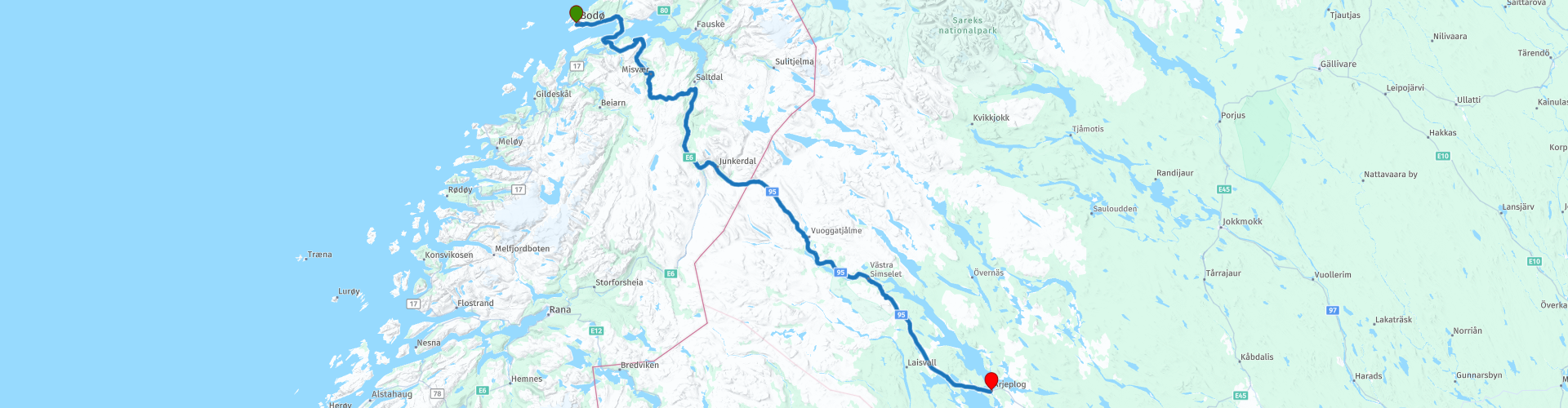
R12 Bodo to Arjeplog

This route was brought to you by:
RouteXpert Arno van Lochem - Senior RX
Last edit: 27-02-2021
 Route Summary
 The beautiful Lofoten have been visited, you are now heading towards the North Cape. However, some kilometers still have to be covered.
The routes are easy for everyone to ride and are on well-paved roads. There may be a single hairpin bend to be taken, but these are easy to do.
If there is a piece of gravel in the route, a warning will be given and a detour will be indicated.
The route runs from Bodø towards the Swedish border. Once you have passed it, you will drive through the vast landscape of Norrbotten's lan along many lakes towards the end of this route, located in Arjeplog. It is a route through a very quiet area, so it is wise to have some food and drink with you for the road. If a restaurant is closed for some reason at a coffee stop, you are not immediately shy.
The participants of the Arctic Challenge were given the coordinate of their next destination when they returned from their ride across the Lofoten the next morning. That turned out to be about 625 kilometers away, in the town of Gällivare (Sweden) at a petrol station.
Beautiful scenery and views, beautiful roads and nice sights, hence the 4-star rating.
 Share this route


Animation

Verdict


Duration
7h 38m

Mode of travel
Car or motorcycle

Distance
296.40 km

Countries


 RouteXpert Review
 Of all western European countries, the Scandinavian countries probably have the most more or less untouched nature. In addition, they are countries that are easily accessible from the Netherlands. Norway is characterized by, among other things, the fjords and the Trollstigen, known to many motorcyclists. And where Sweden is known as wide and relaxing, everyone knows Finland as the land of 1000 lakes. All in all, legitimate reasons to traverse this beautiful nature in the north of Europe by means of a number of routes.
After leaving Lofoten behind, it is time to prepare for the second highlight of the trip, the North Cape. That's still a bit of a drive. In this route you start at the first part.
The route starts in Bodø at the hotel. There is room again to fill the tank if necessary. On the other side of the street, some food and drink can be bought for the road. The route runs through an area where it is not really crowded. If a restaurant is closed for whatever reason at a planned stop, you can fall back on your own food and drinks.
The first part of the route will look familiar, it also occurred in the first part of the tour of the Lofoten. Just after Løding you turn right. You leave the E6 (later you come across it again) and you are now on the 17. After a few kilometers you cross the bridge that takes you to the other side of the Godøstraumen. In this water there are numerous rocks on which the erosion of the water can be clearly seen. This has taken years and years, it is still nice to have a look at it.
Further along the route you will pass Misværfjorden. This is a fjord arm of Skjerstadfjorden in Bodø. The fjord has an inlet between Ljønes in the west and the village of Skjerstad in the east and stretches 15 kilometers south to Misvær at the bottom of the fjord.
Slightly in the fjord are the hamlets Hoset on the west side and Støvset on the east side. Between these places is Store Sandøya and from Støvset there is a bridge to the island and the road fills up to Hoset. The bridge is part of Fv554. Inland in the fjord are the hamlets of Bu, Oldereid and Enget on the west side of the fjord. Oldereid is a power plant at Enget. The hamlet of Espenes is located on the east side. The village of Misvær is located in the innermost part of the fjord.
The first coffee stop is planned at Ljøsenhammern Cafe, a beautifully located restaurant in the 'middle of nowhere'. As mentioned, the location is beautiful, in a hilly area from which you have a pleasant view.
After the coffee stop, it does not take long before you are back on the E6. You also drove this road on the way to Bodø, but then of course in the other direction. The road runs along the Saltelva River. This is a river in the municipality of Saltdal in Nordland. The river flows into the Saltdalsfjord at Rognan. Saltelva is part of the Saltdalsvassdraget, the third largest watercourse in the province of Nordland. The watercourse is 78.1 km long, including Lønselva, and has a catchment area of 1544 km². The average water flow at the mouth is 55.4 m³ / s. The watercourse drains the northern part of Saltfjellet and Junkerdalen.
The Saltelva itself runs 35 km from Saltdalsfjorden near Saltnes, via Saltdalen to Storjord where the rivers Lønselva from the south and Junkerdalselva from the east merge. There is a lot of fishing in the river. The watercourse is one of the largest in Norway, which is almost entirely spared for hydropower development.
About thirty kilometers away you drive past the Adde Zetterquist Kunstgalleri. This gallery is primarily an exhibition of the art of Per Adde and Kajsa Zetterquist. The spectacular building houses two rooms for regular exhibitions of the two artists, as well as an adjoining room for guest exhibitions. The gallery is surrounded by beautiful countryside, at Storjord in Nordland, and is part of the Nordland National Park Center. The main principles of the gallery are the communication of art, nature and Sami culture and offers a wealth of experiences.
In the adjacent Saltdal Turistsenter you can enjoy lunch, the kitchen is Norwegian-oriented. You can also fill the tank at the gas station.
After the lunch stop you actually turn immediately left onto 77. You keep following this road until the end of the route. After 20 kilometers you cross the border with Sweden and the road number changes into the 95.
A number of stops are planned along this road, usually at a large lake, to stretch your legs, drink a cup of coffee or refuel. In this area you drive a lot along large lakes, one even more beautiful and larger than the other. Also, there doesn't seem to be an end to the woods you pass through. They mainly consist of coniferous forests, mountain birch forests, swamps and streams.
Eventually you will drive into Arjeplog and reach the final destination of this route, the Simloc Hotel Drottninggatan. A simple hotel with a good rating. You can eat in one of the surrounding restaurants.
Two campsites are indicated for campers in the vicinity of the end point: Kraja Fritidsanläggning and Nature camp.
If you still have some time, you can visit the Silver Museum in Arjeplog. A museum in which you can view Arjeplog's story of the past ten thousand years of human habitation.
Have fun driving this route!


 Links
Links  Usage
Usage Want to download this route?
You can download the route for free without MyRoute-app account. To do so, open the route and click 'save as'. Want to edit this route?
No problem, start by opening the route. Follow the tutorial and create your personal MyRoute-app account. After registration, your trial starts automatically.  Disclaimer
Use of this GPS route is at your own expense and risk. The route has been carefully composed and checked by a MyRoute-app accredited RouteXpert for use on TomTom, Garmin and MyRoute-app Navigation.
Changes may nevertheless have occurred due to changed circumstances, road diversions or seasonal closures. We therefore recommend checking each route before use.
Preferably use the route track in your navigation system. More information about the use of MyRoute-app can be found on the website under 'Community' or 'Academy'.

Nordland
About this region
Nordland (Norwegian pronunciation: [ˈnûːrlɑn] (listen); Lule Sami: Nordlánnda, Southern Sami: Nordlaante, Northern Sami: Nordlánda, English: Northland) is a county in Norway in the Northern Norway region, bordering Troms og Finnmark in the north, Trøndelag in the south, Norrbotten County in Sweden to the east, Västerbotten County to the southeast, and the Atlantic Ocean (Norwegian Sea) to the west. The county was formerly known as Nordlandene amt. The county administration is in the town of Bodø. The remote Arctic island of Jan Mayen has been administered from Nordland since 1995. In the southern part of the county is Vega, listed on the UNESCO World Heritage Site list.
Read more on Wikipedia
View region
 Statistics
  16
16Amount of RX reviews (Nordland)
 14960
14960Amount of visitors (Nordland)
 783
783Amount of downloads (Nordland)
 Route Collections in this region
 In 12 Days from Oslo to the North Cape
This is a route collection of a motorcycle tour from Oslo to the North Cape, based on a journey by Thomas Falck Østli. A total of twelve routes have been described, but the tour can be extended to more days, more information about this in the reviews.
The routes run through the beautiful landscapes of Norway, including the Lofoten, with many lakes, fjords, rivers, beautiful bridges, beautiful green forests and rugged mountains. During the trip there are also many ferry crossings, keep this in mind in your planning.
You drive longer distances in Norway without encountering a gas station or a restaurant, keep this in mind before you drive. Make sure your tank is full and bring food and drinks. Bring a few bottles of water or Camel bag and fill it up when you stop to refuel. Along the way, breaks are planned for refueling, eating and drinking.
The total trip of almost 3700 kilometers is broken down as follows;
• Day 1 is a 434 kilometer drive from Oslo to Geiranger
• Day 2 is a 238 kilometer drive from Geiranger to Kristiansund
• Day 3 is a 298 kilometer drive from Kristiansund via Trondheim to Verdal
• Day 4 is a 333 kilometer drive from Verdal to Brønnøysund
• Day 5 is a 267 kilometer drive from Brønnøysund to Furøy
• Day 6 is a 296 kilometer drive from Furøy Lofoten to Reine
• Day 7 is a 218 kilometer drive from Reine to Ørsvågvær
• Day 8 is a 274 kilometer drive from Ørsvågvær to Straumsjøen
• Day 9 is a 327 kilometer drive from Straumsjøen to Senjahopen
• Day 10 is a 321 kilometer drive from Senjahopen to Tromsø
• Day 11 is a 420 kilometer drive from Tromsø to Alta
• Day 12 is a 239 km drive from Alta via the North Cape to Skarsvåg
You have the choice to stay overnight at campsites or in hotels. Hotel prices in Norway are not particularly high and breakfast is usually included.
Camping is free almost everywhere, except on private property or where camping is prohibited, indicated by prohibition signs.
If you don't want to camp, there are often cabins for rent on the campsites. For a trip through Norway it is always advisable to bring a tent and other camping gear.
Information about hotels and campsites is included in the directions
Have fun reading, planning and driving this scenic journey to the northernmost tip of Europe.
View Route Collection
6500 kilometers through Scandinavia with the highlights of the Lofoten and the North Cape
The Arctic Challenge Tour, on which this 26-part tour is partly based, is not a speed race. It's a tour. It comes down to agility, good navigation and anticipation. The participants are obliged to adhere to the speed limit of the country concerned. The participants must find the ideal route with the shortest possible distance by complying 100% with the locally applicable traffic rules. Of course, also take maximum speeds into account. The organization checks for violations of the speed limit. In case of gross or repeated exceeding of the maximum speed, disqualification for the relevant stage and for the final classification will follow. Control of the route and speeds is done by means of a track and trace system. This equipment is installed in every vehicle. You can then follow each team accurately in the Back Office. Those staying at home, interested parties and participants can also see the performances of the teams, because you can be followed live via the Internet. The Back Office takes action when a team gets into trouble. (source: website The Arctic Challenge)
That's quite a luxury, having a back office behind you that keeps an eye on you. Most of us will not have that and are on our own or the fellow traveler(s). The only agreement you have with the participants is that you also have to abide by the rules. Fortunately, you don't have to complete this tour in 9 days, like the participants, but you can take it a little longer.
The highlight of the Arctic Challenge in 2020 was the Lofoten, an island group northwest of Norway. The Lofoten archipelago is located in the middle of the wild Norwegian Sea, well above the Arctic Circle. This special region offers a beautiful landscape with imposing mountains, deep fjords and long, wild sandy beaches where the sound of the seabird colonies can always be heard.
The archipelago is best known for its rich fishing tradition. The Lofoten makes a prosperous impression despite their isolated location. The entire economy revolves above all around fishing. The image of the Lofoten is mainly dominated by wooden racks with cod, which hangs to dry. Lofoten fishing has been a household name for centuries. In the middle of winter, the ships set out to catch the fish in just a few months. The rich fishing grounds are due to the North Atlantic Warm Gulf Stream around the islands, in which the fish have their spawning grounds. Oil drilling is not permitted around Lofoten and the cod spawning grounds there.
The next destination for the participants was Sirkka, also known as Levi, a winter sports resort in Finnish Lapland. They stayed there for a few days to go ice-karting and to enjoy the snow by going on a snowmobile or skiing trip. This tour also takes you to Sirkka, but instead of staying there for a few days, you have the option to continue to the North Cape, the second highlight of this trip.
Imagine a place in the far north, where the Atlantic Ocean meets the icy waters of the Arctic Ocean. This place is the North Cape in Western Finnmark in Northern Norway. From here, only the archipelago of Spitsbergen lies between you and the North Pole and the sun shines for 2.5 months at a time; from mid-May to the end of July. Many visitors admire the midnight sun or the sunset over the Barents Sea from the North Cape plateau.
With each route you will find a review with a description of the route, where you pass and what to see along the way. It is also briefly described how the participants in the Arctic Challenge in 2020 had to drive it anyway, from which point to which point. Along the way, markings (route points) have been included that indicate the end points of the stages that the participants had to complete. As mentioned, they covered the distance in 9 days, stages of more than 1000 kilometers were no exception.
Each route ends at a hotel. It is of course not an obligation to use these hotels, you can always find another place to stay in the area, that decision is up to you. My experience, however, is that they are all simple but good hotels for a very reasonable price. They are known and can be booked at booking.com.
The routes of these collections:
R01 - Puttgarden to Angelholm, 280km
R02 - Angelholm to Alingsas, 281km
R03 - Alingsas to Mysen, 261km
R04 - Mysen to Rena, 312km
R05 - Rena to Orkanger, 306km
R06 - Orkanger to Grong, 292km
R07 - Grong to Mo i Rana, 290km
R08 - Mo i Rana to Bodo, 231km
R09 - Roundtour Bodo to Lofoten part 1, 314km
R10 - Roundtour Bodo to Lofoten part 2, 250km
R11 - Roundtour Bodo to Lofoten part 3, 291km
R12 - Bodo to Arjeplog, 295km
R13 - Arjeplog to Jokkmokk, 244km
R14 - Jokkmokk to Pajala, 239km
R15 - Roundtour Sirkka to North Cape part 1, 257km
R16 - Roundtour Sirkka to North Cape part 2, 300km
R17 - Roundtour Sirkka to North Cape part 3, 244km
R18 - Roundtour Sirkka to North Cape part 4, 275km
R19 - Roundtour Sirkka to North Cape part 5, 332km
R20 - Sirkka to Kemi, 299km
R21 - Kemi to Ylivieska, 251km
R22 - Ylivieska to Jalasjarvi, 236km
R23 - Jalasjarvi to Turku, 279km
R24 - Stockholm to Askersund, 271km
R25 - Askersund to Varnamo, 224
R26 - Varnamo to Trelleborg, 259km
Have fun driving these routes!
View Route Collection