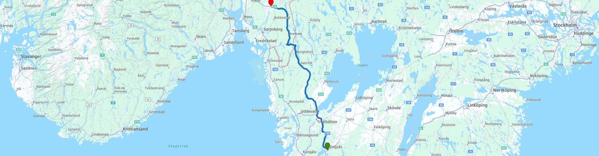
R03 Alingsas to Mysen

This route was brought to you by:
RouteXpert Arno van Lochem - Senior RX
Last edit: 27-02-2021
 Route Summary
 The routes are easy for everyone to ride and are on well-paved roads. There may be a single hairpin bend to be taken, but these are easy to do.
If there is a piece of gravel in the route, a warning will be given and a detour will be indicated.
The route starts in the Swedish town of Alingsås and takes you through beautiful changing and vast landscapes further north. You will pass the Norwegian border on 2/3 of the route. The route ends at the hotel Scandic Brennemoen in Mysen, a somewhat remote hotel that can be booked via booking.com.
The camper has also been thought of, there are a number of campsites indicated where you can rent a hiker's cabin or camp.
The route takes you on excellent roads through beautiful forests and along beautiful lakes. The height differences are also getting bigger. In addition, there is plenty to see along the way. For these reasons, I rate this route with 4 stars.
 Share this route


Animation

Verdict


Duration
7h 10m

Mode of travel
Car or motorcycle

Distance
260.99 km

Countries


 RouteXpert Review
 Of all western European countries, the Scandinavian countries probably have the most more or less untouched nature. In addition, they are countries that are easily accessible from the Netherlands. Norway is characterized by, among other things, the fjords and the Trollstigen, known to many motorcyclists. And where Sweden is known as wide and relaxing, everyone knows Finland as the land of 1000 lakes. All in all, legitimate reasons to traverse this beautiful nature in the north of Europe by means of a number of routes.
The route starts in Alingsås, lying northeast of Gothenburg. When you have almost left this place behind you will pass a gas station and an adjacent supermarket. If you want, you can stock up on some food and drinks for the road. If necessary, you can also fill up the tank at the gas station.
After this you really go on your way, further towards the far north. The route is not very long, you have enough time along the way to look at the sights. Take advantage of that, Sweden (and later Norway) are not only a pleasure to drive, but also to 'sniff culture' and take in the environment well.
After 10 kilometers you will already arrive at the first point where you can take a look, the Brobacka Nature Reserve. This area consists of a pit area of glacial origin. The pits are formed on the east side of a narrow, rocky gorge between the lakes Anten and Mjörn. You can park at the indicated spot, then continue on foot for a few impressive photos.
Barely stepped on again, around the corner from the nature reserve you will find the next place for some nice photos: Anten-Gräfsnäs Järnväg (Anten-Gräfsnäs railway). This is a museum gate line from Anten to Gräfsnäs. Old trains are used, including a steam locomotive from 1911. It is wonderful to see how they are turned with pure manpower on a large plateau to change tracks. Whether you are going to make the journey over the 12 kilometer long railway is of course up to you, but it is always nice to view and photograph the old trains.
On the north coast of the Antenmeer you will pass the Gräfsnäs castle ruins. This castle, or rather a defensive castle, was originally located on the island of Loholmen in Lake Anten and was the ancestral home of the Leijonhufvud family. The castle probably dates back to around the 14th century. Archaeological excavations have uncovered the remains of a 200 meter long bridge leading to the castle and dates back to the year 1301. Detail is that the castle burned down three times in its existence, at intervals of exactly 100 years.
The parks around the ruin are of historical value and really beautifully landscaped. Be amazed by its beauty during the walk to the ruin.
After the coffee break in Vänersborg you continue through a beautiful green area on beautiful main roads. They are not really busy. After three stops within 25 kilometers, it is now time to make some kilometers, you still have to go a bit to the end. Don't forget to stop every now and then, there are so many beautiful things to see in Scandinavian nature. The varied landscape means that you will not get bored on the sometimes best along straights. But for a while the road winds through the meadows again, so plenty of variety!
In the town of Ed, located between the two lakes, you will find Ed's MC and motorcycle museum. The museum is located in 'The Galleria', with an area of 1000 square meters, in the basement under the grocery store 'Willys hemma' in downtown Ed.
The collection includes classic motorcycles, boat engines, model airplanes, radios, sewing machines, etc. There are about 150 bicycles on display, including a complete range of Swedish Rexes from 1923-1953 and the 1927 EBE which was manufactured in the town of Åmål, 35 miles east of Ed.
You can combine your visit with a lunch in one of the restaurants in the area, for example at Hotel Carl XII 100 meters away.
After lunch, turn off just outside Ed and turn onto the O2183. Get your chest wet from this point on: 45 kilometers of great driving pleasure. Beautiful surroundings, tight asphalt, wonderful curves, what more could you want. Yes, a little sun would be nice, then it is complete.
You would almost forget that you have to stop every now and then at one of the beautiful lakes you pass, they are so wonderfully relaxing! There are two points where you can enjoy all that beauty, but there are many more places where you can stop for a photo.
After driving more than 30 kilometers on the O2183 you will arrive at the border and exchange Sweden for Norway. It's a good thing there is a sign with 'Riksgräns Norge' on it, otherwise you would probably not have noticed that you are on Norwegian territory from here. The next more than 2250 kilometers will not change that and in those 2250 kilometers you will see a lot of beautiful things.
Also on the Norwegian side of the border it is certainly not a punishment to drive the first 20 kilometers, the start is good in any case. After the exit to the right, don't forget to stop at the bridge over the water. Beautiful piece of nature!
About ten kilometers after the refueling stop you arrive at Strømsfoss mølle (the mill of Strømsfoss). It was the canal builder Engebret Soot who built the first mill in Strømsfoss and founded a sawmill, brick factory, dye house and tannery there. Later, Even Soot (son of Engebret) established a nail forge on the south side of the waterfall. The first mill at the waterfall burned down in 1846. Later, two mills were built in the area that also burned down. The current mill was built in 1897 by Einar Haneborg. The drive in the mill consisted of 6 smaller water wheels, one for each mill. The construction mill was constantly being modernized. In 1951 it was among other things added a floor. The mill was in operation until 1966. Whether you visit the mill or not, it is fun to walk around here, look and of course take a few pictures.
The part of the route after the Strømsfoss mølle is again delicious. Wonderfully quiet road with nice curves and beautiful asphalt through still beautiful surroundings. Far too quickly to your liking, you drive into Ørje for the coffee break. Fortunately, the location makes up for a lot, just enjoy a cup of coffee by the water.
After the coffee break, no more sights on the route, although of course there are still beautiful surroundings to see around you. Of course you should still enjoy that. And you never tire of photos, so stop regularly for that.
Just behind Mysen you come to the end of the route, the Scandic Brennemoen hotel. The hotel is located just outside the city, but has all mod cons, including free wifi, a restaurant and a bar. So once you have settled in the hotel, you can relive the route with your fellow travelers while enjoying a beer during the debriefing.
For campers, three campsites are indicated in the vicinity of the end point: Ramstadkrysset Camping, Olberg Camping and Rakkestad-Vika Camping.
Have fun driving this route!


 Links
Links  Usage
Usage Want to download this route?
You can download the route for free without MyRoute-app account. To do so, open the route and click 'save as'. Want to edit this route?
No problem, start by opening the route. Follow the tutorial and create your personal MyRoute-app account. After registration, your trial starts automatically.  Disclaimer
Use of this GPS route is at your own expense and risk. The route has been carefully composed and checked by a MyRoute-app accredited RouteXpert for use on TomTom, Garmin and MyRoute-app Navigation.
Changes may nevertheless have occurred due to changed circumstances, road diversions or seasonal closures. We therefore recommend checking each route before use.
Preferably use the route track in your navigation system. More information about the use of MyRoute-app can be found on the website under 'Community' or 'Academy'.

Ostfold
About this region
Østfold [ˈœ̂stfɔɫ] (listen) is a traditional region, a former county and a current electoral district in southeastern Norway. It borders Akershus and southwestern Sweden (Västra Götaland County and Värmland), while Buskerud and Vestfold are on the other side of Oslofjord. The county's administrative seat was Sarpsborg. The county controversially became part of the newly established Viken County on 1 January 2020.
Many manufacturing facilities are situated here, such as the world's most advanced biorefinery, Borregaard in Sarpsborg. Fredrikstad has shipyards. There are granite mines in Østfold and stone from these were used by Gustav Vigeland.
The county slogan is "The heartland of Scandinavia". The local dialect is characterized by its geographical proximity to Sweden.
Read more on Wikipedia
Many manufacturing facilities are situated here, such as the world's most advanced biorefinery, Borregaard in Sarpsborg. Fredrikstad has shipyards. There are granite mines in Østfold and stone from these were used by Gustav Vigeland.
The county slogan is "The heartland of Scandinavia". The local dialect is characterized by its geographical proximity to Sweden.
View region
 Statistics
  5
5Amount of RX reviews (Ostfold)
 11872
11872Amount of visitors (Ostfold)
 299
299Amount of downloads (Ostfold)
 Route Collections in this region
 Top Car and Motorcycle tour through Sweden and Norway
Sweden and Norway are beautiful countries. You will find nice cities, but also impressive nature reserves. This versatility makes Sweden & Norway the perfect countries for an impressive motorcycle holiday.
In this collection 14 beautiful routes through Sweden & Norway.
Good preparation is half the battle, so read the tips below carefully.
1. Check the weather forecast. It can be very hot in Sweden & Norway, but it can also get very cold. Always check the weather forecast before you go, so that you can pack the right clothes.
2. Decide in advance which route or routes you want to follow. This way you don't drive around like a headless chicken and you can make the most of your days off in these beautiful countries.
3. Familiarize yourself with the traffic rules. In Sweden & Norway, in some situations, slightly different rules apply than in the Netherlands. By immersing yourself in the traffic rules, you prevent (unknowingly) committing a traffic violation and/or putting yourself in a dangerous situation.
It is also wise to book the accommodations in advance. It might be more fun to drive through these countries on spec, but you don't want to drive around endlessly to find a place to sleep. If you go to Sweden or Norway during the high season, the chance that you will have to look for a place to sleep is greatest. It is also possible to camp during your motorcycle trip, but find out in advance where this is and is not allowed. You are not allowed to pitch your tent everywhere.
As the largest country in Scandinavia, you can enjoy extensive tours in a unique environment. Forests, lakes, nature parks and agricultural areas largely determine the landscape, which also consists of flat areas and rolling hills. Around the Swedish-Norwegian border is the Scandinavian Highlands, where the mountains rise locally to 2100 meters.
Norway is known for its amazing natural beauty. Fjords that go into the country tens of kilometers deep, snow-covered plateaus, sharp mountain peaks and vast forests. In this sparsely populated country, most people live in the cities, of which the capital Oslo is the largest.
Tolls have to be paid on a large number of roads in Norway. If you approach a toll road, you can continue without stopping. With cameras above the road, the license plate of the vehicle is scanned, not the registration number of the trailer or caravan. It takes quite some time to process the photos.
The bill is then sent home within four to six months by Euro Parking Collection (EPC) in London.
Mandatory on the motorcycle: Safety vest - A motorcyclist must bring at least one safety vest. In the event of a breakdown or accident, the driver is obliged to wear a safety vest. The ANWB advises motorcyclists to also bring a safety vest for a possible passenger.
Advice: First aid kit, motorcyclists are advised to bring a first aid kit.
View Route Collection
6500 kilometers through Scandinavia with the highlights of the Lofoten and the North Cape
The Arctic Challenge Tour, on which this 26-part tour is partly based, is not a speed race. It's a tour. It comes down to agility, good navigation and anticipation. The participants are obliged to adhere to the speed limit of the country concerned. The participants must find the ideal route with the shortest possible distance by complying 100% with the locally applicable traffic rules. Of course, also take maximum speeds into account. The organization checks for violations of the speed limit. In case of gross or repeated exceeding of the maximum speed, disqualification for the relevant stage and for the final classification will follow. Control of the route and speeds is done by means of a track and trace system. This equipment is installed in every vehicle. You can then follow each team accurately in the Back Office. Those staying at home, interested parties and participants can also see the performances of the teams, because you can be followed live via the Internet. The Back Office takes action when a team gets into trouble. (source: website The Arctic Challenge)
That's quite a luxury, having a back office behind you that keeps an eye on you. Most of us will not have that and are on our own or the fellow traveler(s). The only agreement you have with the participants is that you also have to abide by the rules. Fortunately, you don't have to complete this tour in 9 days, like the participants, but you can take it a little longer.
The highlight of the Arctic Challenge in 2020 was the Lofoten, an island group northwest of Norway. The Lofoten archipelago is located in the middle of the wild Norwegian Sea, well above the Arctic Circle. This special region offers a beautiful landscape with imposing mountains, deep fjords and long, wild sandy beaches where the sound of the seabird colonies can always be heard.
The archipelago is best known for its rich fishing tradition. The Lofoten makes a prosperous impression despite their isolated location. The entire economy revolves above all around fishing. The image of the Lofoten is mainly dominated by wooden racks with cod, which hangs to dry. Lofoten fishing has been a household name for centuries. In the middle of winter, the ships set out to catch the fish in just a few months. The rich fishing grounds are due to the North Atlantic Warm Gulf Stream around the islands, in which the fish have their spawning grounds. Oil drilling is not permitted around Lofoten and the cod spawning grounds there.
The next destination for the participants was Sirkka, also known as Levi, a winter sports resort in Finnish Lapland. They stayed there for a few days to go ice-karting and to enjoy the snow by going on a snowmobile or skiing trip. This tour also takes you to Sirkka, but instead of staying there for a few days, you have the option to continue to the North Cape, the second highlight of this trip.
Imagine a place in the far north, where the Atlantic Ocean meets the icy waters of the Arctic Ocean. This place is the North Cape in Western Finnmark in Northern Norway. From here, only the archipelago of Spitsbergen lies between you and the North Pole and the sun shines for 2.5 months at a time; from mid-May to the end of July. Many visitors admire the midnight sun or the sunset over the Barents Sea from the North Cape plateau.
With each route you will find a review with a description of the route, where you pass and what to see along the way. It is also briefly described how the participants in the Arctic Challenge in 2020 had to drive it anyway, from which point to which point. Along the way, markings (route points) have been included that indicate the end points of the stages that the participants had to complete. As mentioned, they covered the distance in 9 days, stages of more than 1000 kilometers were no exception.
Each route ends at a hotel. It is of course not an obligation to use these hotels, you can always find another place to stay in the area, that decision is up to you. My experience, however, is that they are all simple but good hotels for a very reasonable price. They are known and can be booked at booking.com.
The routes of these collections:
R01 - Puttgarden to Angelholm, 280km
R02 - Angelholm to Alingsas, 281km
R03 - Alingsas to Mysen, 261km
R04 - Mysen to Rena, 312km
R05 - Rena to Orkanger, 306km
R06 - Orkanger to Grong, 292km
R07 - Grong to Mo i Rana, 290km
R08 - Mo i Rana to Bodo, 231km
R09 - Roundtour Bodo to Lofoten part 1, 314km
R10 - Roundtour Bodo to Lofoten part 2, 250km
R11 - Roundtour Bodo to Lofoten part 3, 291km
R12 - Bodo to Arjeplog, 295km
R13 - Arjeplog to Jokkmokk, 244km
R14 - Jokkmokk to Pajala, 239km
R15 - Roundtour Sirkka to North Cape part 1, 257km
R16 - Roundtour Sirkka to North Cape part 2, 300km
R17 - Roundtour Sirkka to North Cape part 3, 244km
R18 - Roundtour Sirkka to North Cape part 4, 275km
R19 - Roundtour Sirkka to North Cape part 5, 332km
R20 - Sirkka to Kemi, 299km
R21 - Kemi to Ylivieska, 251km
R22 - Ylivieska to Jalasjarvi, 236km
R23 - Jalasjarvi to Turku, 279km
R24 - Stockholm to Askersund, 271km
R25 - Askersund to Varnamo, 224
R26 - Varnamo to Trelleborg, 259km
Have fun driving these routes!
View Route Collection