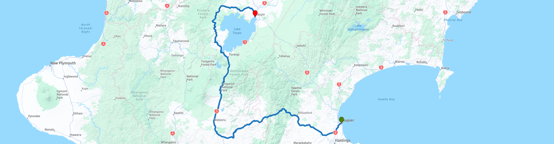
11 Napier to Taupo over the Central Plateau

This route was brought to you by:
RouteXpert Nick Carthew - (MRA Master)
Last edit: 03-02-2021
 Route Summary
  Share this route


Animation

Verdict


Duration
6h 39m

Mode of travel
Car or motorcycle

Distance
328.21 km

Countries

 RouteXpert Review
 The old Springvale Suspension Bridge at RP 10 is set in a stunning landscape as it spans the Rangitikei River. It is now used as a pedestrian bridge. The bridge was built to be practical and functional. But in the 21st century we can now admire its engineering and celebrate its rarity – very few examples of this type of suspension bridge remain. Also a nice place to cool off if it's a hot day.
The route joins the State Highway 1 at RP 12 climbing higher and higher up onto North Island Central Plateau. Often called the North Island Volcanic Plateau, the Central Plateau is located in the centre of the North Island. The area is famous for its three active volcanoes: Mount Ruapehu. RP 14, Mount Ngauruhoe and Mount Tongariro at RP 17.
Taihape in the South, Ohakune, in the West, Taupo in the North and the Kaweka Ranges in the East mark the boundaries of the region that includes some of the most well known towns in the country. Ohakune proudly holds the title of “carrot growing capital of New Zealand” and, Turangi, for example, is known as the “trout fishing capital of the world”.
Most of the population of the Central Plateau live on the shores of Lake Taupo, the largest lake in New Zealand and the largest freshwater lake by surface area in the whole of Oceania. Tourism is a particularly important industry in this area, much due to the excellent conditions for activities such as skiing and fishing. This region is also the largest area of man-made forest in the Southern Hemisphere.
The NZ Army have a military base and a live firing range on the Central Plateau. The village of Waiouru has developed because of the NZ Army presence and several shops, cafes, restaurants, bars and the National Army Museum serve the passing trade. I have suggested a fuel and lunch stop here at RP 13. The Rustic Eating House serves mouthwatering food that will amaze your taste buds. Head chef Tyson Burrows, known throughout New Zealand from the show My Restaurant Rules NZ has taken 'stop for a bite to eat' to the next level.
From here the road name changes to The Volcanic Loop Highway, a name that entices you to ride it. And as the name suggests the volcanoes are clearly visible (weather permitting) RP 14 has a layby enabling you to stop for a photo of Mount Ruapehu and her sister peaks. Mount Ruapehu is the tallest of the three volcanoes standing at 2797 m. Not far from here at RP 15 is the highest point of the route at 1080 m. A few hundred metres further on is the regional border from Manawatu-Wanganui to Waikato, then you'll have a view of Mount Ngāuruhoe, the second tallest at 2291 m and standing behind is the smaller Mount Tongariro 1967 m.
I've used a hard via RP at RP 19 as it's a must see. The Tokaanu Thermal Walk is a short walking track through the Tokaanu thermal area that leads past steaming hot mineral pools and small mud pools dotted amongst the native bush. The people of local Māori tribe Ngāti Kurauia have lived alongside the Tokaanu Stream and thermal area since the 16th century. To this day they use the Thermal Pools for relaxation, bathing, and their therapeutic qualities. The continuous supply of hot water and steam vents are used for their communal cooking, and dyeing of traditional clothing.
You can leave the route briefly at RP 20 to get a view of Lake Taupo, as previously mentioned, the largest lake in New Zealand.
The route navigates around Lake Taupo through an ever changing landscape as it makes it's way to the town of Taupo and the end of the route.
Taupo is a town that encapsulates all that NZ is known for when it comes to fun, adventure and staggeringly beautiful nature and a second day here will allow you to experience some of it for yourself.
You could visit the 'Craters of the Moon' Named for its other-worldly atmosphere, the Craters of the Moon thermal area sprang up in the 1950s when the nearby power station lowered underground water levels. As hot water was withdrawn from deep within the field, the water level in the deep reservoir dropped and the remaining water boiled more violently, producing more steam. Large quantities of this extra steam escaped at Craters of The Moon. Enjoy this fantastic geothermal area long well-formed pathways and with elevated viewing platforms. You'll see interesting plants that have adapted to thrive in the hot steamy conditions.
At Huka Falls you can witness the phenomenon of natural hydro power with more than 220,000 litres of water per sec barreling over 11 m high waterfall. The Waikato River, New Zealand's longest river, moves gracefully north from Lake Taupō between banks 100 metres apart. Just before the Huka Falls it enters a shallow ravine of hard volcanic rock. The effect is nature's large-scale equivalent of a fire hose feeding into a very fine nozzle.
The previously placid waters roar and rumble at great speed along the ravine before bursting out over Huka Falls to crash into the turbulent pool 11 metres below. A foot bridge right at the top of the falls puts you in a prime position to get up close and witness the powerful display of water blasting by -. If you'd like to see the power and fury of the falls up close, try a jet boat ride or river cruise.
For thrill seekers, why not experience a skydive with Taupo Tandem Skydiving or a bungy jump.
For something more relaxing, explore the tranquil beauty of Lake Taupo by hiring a kayak and visiting the rock carvings – only accessible by boat or kayak. Nestled in the cliffs that surround Lake Taupo, these Maori carvings were created by master carver Matahi Whakataka-Brightwell to portray the story of his ancestor Ngātoroirangi and are an impressive 10 metres in height.
There is so much to see and do in Taupo, I think a second night is essential. Because of it's popularity there are many different types of accommodation and I have included links below as suggestions. The route ends at Taupo McDonald's giving you a chance to catch your breath and take in what this great day's travelling has given you before finding your accommodation.
Enjoy


 Links
Links  Usage
Usage Want to download this route?
You can download the route for free without MyRoute-app account. To do so, open the route and click 'save as'. Want to edit this route?
No problem, start by opening the route. Follow the tutorial and create your personal MyRoute-app account. After registration, your trial starts automatically.  Disclaimer
Use of this GPS route is at your own expense and risk. The route has been carefully composed and checked by a MyRoute-app accredited RouteXpert for use on TomTom, Garmin and MyRoute-app Navigation.
Changes may nevertheless have occurred due to changed circumstances, road diversions or seasonal closures. We therefore recommend checking each route before use.
Preferably use the route track in your navigation system. More information about the use of MyRoute-app can be found on the website under 'Community' or 'Academy'.