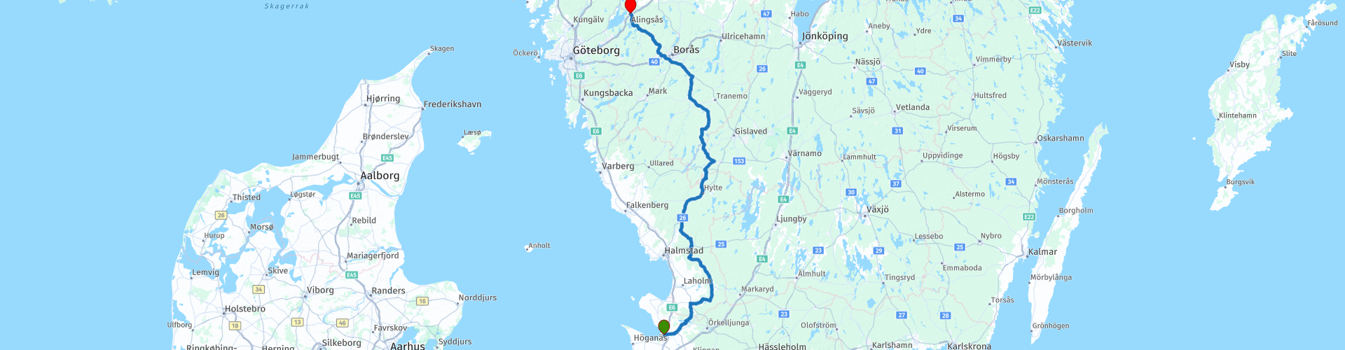
R02 Angelholm to Alingsas

This route was brought to you by:
RouteXpert Arno van Lochem - Senior RX
Last edit: 20-05-2021
 Route Summary
 The routes are easy for everyone to drive and are on well-paved roads. There may be a single hairpin bend to be taken, but these are easy to do.
If there is a piece of gravel in the route, a warning will be given and a detour will be indicated.
The route takes you through four lån's (provinces), namely Skåne, Hallands, Jönköpings and Vastra Gotalands. You start in Ängelholm and go on large and partly smaller roads to the north. You will pass several lakes where you have to take the time to stop, beautiful and relaxing. The landscape alternates between forest and meadow, where the forest is increasingly gaining the upper hand. You will pass a brewery and a motorcycle museum. The route ends at the Grand Hotel in Alinsås, a nice hotel that can be booked through booking.com.
The camper has also been thought of, there are a number of campsites indicated where you can rent a hiker's cabin or camp.
The route takes you on excellent roads through beautiful forests and along beautiful lakes. The height differences are also getting bigger. In addition, there is plenty to see along the way. For these reasons, I rate this route with 4 stars.
 Share this route


Animation

Verdict


Duration
8h 0m

Mode of travel
Car or motorcycle

Distance
280.97 km

Countries

 RouteXpert Review
 Of all western European countries, the Scandinavian countries probably have the most more or less untouched nature. In addition, they are countries that are easily accessible from the Netherlands. Norway is characterized by, among other things, the fjords and the Trollstigen, known to many motorcyclists. And where Sweden is known as wide and relaxing, everyone knows Finland as the land of 1000 lakes. All in all, legitimate reasons to traverse this beautiful nature in the north of Europe by means of a number of routes.
The route starts in Ängelholm, located in the south of Sweden. Soon you will leave this place behind to buy some food and drinks for the road in Munka-Lhungby at the local supermarket. You can also fill up the tank at the gas station if necessary.
After any necessary shopping for the road, the route really starts. After about 20 kilometers you will see the first of the many lakes that you will pass today. One even more beautiful and bigger than the other. This lake is the Rössjön and has an area of 3.5 square kilometers. The lake is part of the Rönne basin. Nice place to stop for a photo.
A little further in the route you will see another lake on the right, Oxhultasjön. That is a lake through which the river Smedjeån flows. You may not expect it, but this lake is just under 3 meters deep. With an area of 1.6 square kilometers, it forms an important part of the Lagan catchment area.
The lake is known for its unspoilt nature with a rich bird life, you will encounter cranes and geese.
Just after this lake there is some disagreement between TomTom and Garmin at the intersection. TomTom lets you drive straight ahead, then you have to turn in an almost impossible way. Garmin just sends you to the left and that is allowed and possible.
Just behind the town of Knäred you will pass the Brovikens Brewery. This is one of the smallest brewery museums in the south of Sweden. The brewery was founded by Ivar Larsson in 1926 near a small bulge of the Krokån, roughly where the bridge crosses Sjöaredsvägen. Two years later, Johan Svensson from Mörkhult takes over the company and it remains within the family until the closure in 1975. Really nice to have a look here.
You will also find Prästaskogen close to the museum. The nature reserve with the new suspension bridge over der Krokån is a place that gets a lot of attention for its beauty, the landscape, the nearly five-meter-high waterfalls of the river and the sweeping progression of the water that has been cutting stones for millennia. It is wonderful to see how the water manages to find a path between and over the stones, forming a spectacular spectacle.
About ten kilometers further you can stop at a beautiful nature reserve, the Mätocka Heide. A visit to this area is a journey through time. You get an idea how magnificent, desolate and yet beautiful the former Halland heath once was. If you are lucky you can hear the black grouse playing on an early spring morning. The heathland covers an area of 156 hectares and has been protected since 1978. Really stop and enjoy the view over the lake after a short walk of 200 meters!
The route winds further through endless forests and along seemingly countless lakes. Before you know it, you'll cross the lån border and enter Västra Götalands. Not that it will be anything else, the forests and the lakes still look the same.
Ten kilometers after the refueling stop you will again pass a large lake, Visen. This is a lake that is part of the Ätran basin. The lake is 32.5 meters deep and has an area of over 182 square kilometers. Nice place to stop, stretch your legs and take a picture.
Just before Svenljunga you come to the exit to the Bynanders Motor Museum. That is a museum with about 66 cars and more than 200 mopeds and motorcycles, radios and a collection from an old country store. There is a cafeteria here where you can get some simple dishes, both food and drink.
If you don't visit the museum, you can stop in the center of Svenljunga at Ewas Cafe for a cup of coffee.
After coffee you will arrive after 15 kilometers on the 27, which runs to today's final destination, Alingsås. But before you get there you will find Älmås Nature Reserve on the right. It is 35 hectares and has been protected since 2006.
Piles and stone walls line old fields and meadows. Old deciduous trees such as elm, ash, hornbeam, beech, oak, birdberry, linden and maple grow between the fields. The area bears traces of older agricultural landscapes with fossil arable land and house foundations. Over the years, the open areas have been reduced in size and replaced by groves and forests. Plants found include horseradish, thyme, bellflower, hay bale and stag beetle. Lichens and mosses that deserve protection grow on the old trees. Lung lichens, elm lichens, and goldencap moss are some of the species found in the reserve. The fungi cinnabar tick and chanterelle mussel are common.
The route runs through the nature reserve, the road consists of two lanes of gravel. If you don't feel like doing this, keep following the 27, more than 800 meters further you drive on the route again.
As soon as you enter Alingsås there is one last opportunity to enjoy one last lake called Gerdsken. Walking up a scaffold between the trees and contemplating the 'skyline' of the place where you are going to spend the night is worth a photo.
Three kilometers further you will arrive at the overnight address, which is also the end point of the route, Grand Hotel Alinsås. For campers there are two campsites in the area marked as POIs: Lövekulle camping and Lygnareds Camping.
Have fun driving this route!


 Links
Links  Usage
Usage Want to download this route?
You can download the route for free without MyRoute-app account. To do so, open the route and click 'save as'. Want to edit this route?
No problem, start by opening the route. Follow the tutorial and create your personal MyRoute-app account. After registration, your trial starts automatically.  Disclaimer
Use of this GPS route is at your own expense and risk. The route has been carefully composed and checked by a MyRoute-app accredited RouteXpert for use on TomTom, Garmin and MyRoute-app Navigation.
Changes may nevertheless have occurred due to changed circumstances, road diversions or seasonal closures. We therefore recommend checking each route before use.
Preferably use the route track in your navigation system. More information about the use of MyRoute-app can be found on the website under 'Community' or 'Academy'.
Hallands lan
About this region
Halland County (Swedish: Hallands län) is a county (län) on the western coast of Sweden. It corresponds roughly to the cultural and historical province of Halland. The capital is Halmstad.
It borders the counties of Västra Götaland, Jönköping, Kronoberg, Scania and the sea of the Kattegat.
Read more on Wikipedia
It borders the counties of Västra Götaland, Jönköping, Kronoberg, Scania and the sea of the Kattegat.
View region
 Statistics
  3
3Amount of RX reviews (Hallands lan)
 8470
8470Amount of visitors (Hallands lan)
 204
204Amount of downloads (Hallands lan)
 Route Collections in this region
 South Sweden in 9 days
Southern Sweden, Götaland: a very varied area. In the south mainly flat, meadows, sea, views, beach, busy ports. More to the north, dense forests, hills, gravel roads, quiet towns (we would call them villages), lakes. And then Öland: a large, flat island with several surprises such as the two lighthouses, the Iron Age fortress on the southern tip, nice little harbours, castles and ruins, also of the Swedish royal couple. And wooden houses everywhere, nature, friendly people, space. The word "cute" sometimes crosses my mind. So knotty. The roads are mostly good, even the gravel roads are fine without any off-road experience or motorcycle. This route collection contains 9 routes of more than 2000 kilometers and takes you along the outer edges of Götaland: from Malmö along the east coast via Ystad, Karlshamm, Karlskrona and Kalmar to the island of Öland. From there the route heads inland to Vimmerby, back to the coast at Västervik, up to Linköping and Motala to the large Lake Vättern. Further down via Jonköping to Gothenburg on the west coast and then via a trip inland to enjoy the forests, lakes, gravel roads and nature via Varberg, Halmstad and Helsingborg back to Malmö.
The starting point is Malmö, at ""the bridge"" over the Kattengat between Denmark and Sweden. We drove there by taking the ferry from Puttgarden to Rødby and then crossing the bridge over the Danish islands of Lolland, Falster and Sjaelland via Copenhagen. But you can also take the ferry from Rostock to Trelleborg. Or you can drive all the way overland via Kolding and Odense in Denmark.
In addition to the sights below, there are special towns, nature reserves and castles/mansions in which route you can admire.
Route 1 goes along the coast of the southernmost tip of Sweden, the province of Skåne, through beautiful nature reserves and well-known towns such as Ystad to Karlshamm. Sights: a Viking village at Skanör, Skanör itself, Smygehuk (the southernmost tip of Sweden), Ystad (Wallander!), the stone formation at Käseberga, car museum at Simrishamn.
Route 2 goes through the province of Blekinge past towns like Ronneby and Kalmar to the island of Öland. Sights: kitesurf beach at Kristianopel, rock formation at Gettlinge, lighthouse Långe Jan.
Route 3 goes over Öland and then some more into the forests of the mainland towards Vimmerby. Sights: the ancient castle at Eketorp, Trollskogen (forest with strangely shaped trees and a beach with the wreck of a stranded boat), lighthouse Långe Erik, the special rock formations in the sea of Byrums raukar, Aboda lake and viewpoint.
Route 4 is a bit shorter because you then end at Vimmerby: the birthplace of Astrid Lindgren (from Pippi, among others). Sights: a moose park, an ancient oak, Vimmerby with Astrid Lindgren's amusement park and birth house annex museum.
Route 5 takes you back to the east coast at Västervik and then heads north and back inland to Linköping. Sights: a moose park (more beautiful than the previous day), a troll forest at Gamleby (ABBA city...), knight's castle Ekenäs, the Göta Canal with a lock complex.
Route 6 is also shorter and continues along the Göta Canal to Motala on Lake Vättern and then south to Gränna, where you can cross over to Visingsö Island. The route is shorter because you then have time to visit Visingsö. Sights: car and motorcycle museum and aquarium in Motala, Alvastra monastery ruins, Visingsö, observation tower, boat trip.
Route 7 takes you via Jönköping to Gothenburg. Sights: old wooden houses near Huskvarna (Jönköping) and of course Gothenburg.
Route 8 goes back into the country so you can enjoy the beautiful forests and lakes and gravel roads again. Then back to the coast with nice towns such as Varberg and Falkenberg. Sights: an old mill, a wooden bathhouse in the sea, beach, museum with remains of aircraft from the Second World War.
Route 9 takes you back to Malmö, although you can also cross over to Denmark earlier at Helsingborg. First you pass the beautiful city of Halmstad and the viewpoint at Mölle. Sights: a special bakery annex lunchroom, beach that can be driven on, lighthouse.
A collection with very varied routes, many sights with something for everyone, excellent roads and also pieces of gravel that can be ridden. Of course you can change the daily schedule by making routes longer, shortening or combining them. If you skip all the sights, you can also drive this in 7 days.
View Route Collection
6500 kilometers through Scandinavia with the highlights of the Lofoten and the North Cape
The Arctic Challenge Tour, on which this 26-part tour is partly based, is not a speed race. It's a tour. It comes down to agility, good navigation and anticipation. The participants are obliged to adhere to the speed limit of the country concerned. The participants must find the ideal route with the shortest possible distance by complying 100% with the locally applicable traffic rules. Of course, also take maximum speeds into account. The organization checks for violations of the speed limit. In case of gross or repeated exceeding of the maximum speed, disqualification for the relevant stage and for the final classification will follow. Control of the route and speeds is done by means of a track and trace system. This equipment is installed in every vehicle. You can then follow each team accurately in the Back Office. Those staying at home, interested parties and participants can also see the performances of the teams, because you can be followed live via the Internet. The Back Office takes action when a team gets into trouble. (source: website The Arctic Challenge)
That's quite a luxury, having a back office behind you that keeps an eye on you. Most of us will not have that and are on our own or the fellow traveler(s). The only agreement you have with the participants is that you also have to abide by the rules. Fortunately, you don't have to complete this tour in 9 days, like the participants, but you can take it a little longer.
The highlight of the Arctic Challenge in 2020 was the Lofoten, an island group northwest of Norway. The Lofoten archipelago is located in the middle of the wild Norwegian Sea, well above the Arctic Circle. This special region offers a beautiful landscape with imposing mountains, deep fjords and long, wild sandy beaches where the sound of the seabird colonies can always be heard.
The archipelago is best known for its rich fishing tradition. The Lofoten makes a prosperous impression despite their isolated location. The entire economy revolves above all around fishing. The image of the Lofoten is mainly dominated by wooden racks with cod, which hangs to dry. Lofoten fishing has been a household name for centuries. In the middle of winter, the ships set out to catch the fish in just a few months. The rich fishing grounds are due to the North Atlantic Warm Gulf Stream around the islands, in which the fish have their spawning grounds. Oil drilling is not permitted around Lofoten and the cod spawning grounds there.
The next destination for the participants was Sirkka, also known as Levi, a winter sports resort in Finnish Lapland. They stayed there for a few days to go ice-karting and to enjoy the snow by going on a snowmobile or skiing trip. This tour also takes you to Sirkka, but instead of staying there for a few days, you have the option to continue to the North Cape, the second highlight of this trip.
Imagine a place in the far north, where the Atlantic Ocean meets the icy waters of the Arctic Ocean. This place is the North Cape in Western Finnmark in Northern Norway. From here, only the archipelago of Spitsbergen lies between you and the North Pole and the sun shines for 2.5 months at a time; from mid-May to the end of July. Many visitors admire the midnight sun or the sunset over the Barents Sea from the North Cape plateau.
With each route you will find a review with a description of the route, where you pass and what to see along the way. It is also briefly described how the participants in the Arctic Challenge in 2020 had to drive it anyway, from which point to which point. Along the way, markings (route points) have been included that indicate the end points of the stages that the participants had to complete. As mentioned, they covered the distance in 9 days, stages of more than 1000 kilometers were no exception.
Each route ends at a hotel. It is of course not an obligation to use these hotels, you can always find another place to stay in the area, that decision is up to you. My experience, however, is that they are all simple but good hotels for a very reasonable price. They are known and can be booked at booking.com.
The routes of these collections:
R01 - Puttgarden to Angelholm, 280km
R02 - Angelholm to Alingsas, 281km
R03 - Alingsas to Mysen, 261km
R04 - Mysen to Rena, 312km
R05 - Rena to Orkanger, 306km
R06 - Orkanger to Grong, 292km
R07 - Grong to Mo i Rana, 290km
R08 - Mo i Rana to Bodo, 231km
R09 - Roundtour Bodo to Lofoten part 1, 314km
R10 - Roundtour Bodo to Lofoten part 2, 250km
R11 - Roundtour Bodo to Lofoten part 3, 291km
R12 - Bodo to Arjeplog, 295km
R13 - Arjeplog to Jokkmokk, 244km
R14 - Jokkmokk to Pajala, 239km
R15 - Roundtour Sirkka to North Cape part 1, 257km
R16 - Roundtour Sirkka to North Cape part 2, 300km
R17 - Roundtour Sirkka to North Cape part 3, 244km
R18 - Roundtour Sirkka to North Cape part 4, 275km
R19 - Roundtour Sirkka to North Cape part 5, 332km
R20 - Sirkka to Kemi, 299km
R21 - Kemi to Ylivieska, 251km
R22 - Ylivieska to Jalasjarvi, 236km
R23 - Jalasjarvi to Turku, 279km
R24 - Stockholm to Askersund, 271km
R25 - Askersund to Varnamo, 224
R26 - Varnamo to Trelleborg, 259km
Have fun driving these routes!
View Route Collection