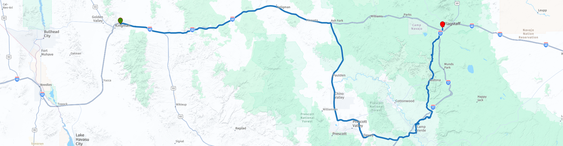
R03 Kingman Flagstaff

This route was brought to you by:
RouteXpert Hans van de Ven (Mr.MRA)
Last edit: 29-12-2019
 Route Summary
 During this journey you will travel through the following states: California, Arizona, Utah & Nevada.
The roads are good, the area hilly and dry and the views beautiful, definitely stop in Sedona and don't forget your camera!
Starting point: Best Western A Wayfarer's Inn.
End point: Hotel Days Inn Flagstaff.
The route has been made the same for TomTom, Garmin and MyRoute-app Navigation users.
Thanks to Richard & Lisa for the information!
 Share this route


Animation

Verdict


Duration
4h 48m

Mode of travel
Car or motorcycle

Distance
388.84 km

Countries

 RouteXpert Review
 The center of Flagstaff dates from 1900. There are unique shops, restaurants and small galleries. The Visitor Center is located in the former train station. Here you can go for information about sights.
So you are going to Flagstaff today. The first part of the trip is about the Interstate 40, after which you go into the interior of Arizona to see different riches of the state of Arizona. The route takes you via Prescott and Camp Verde to the famous Montezuma Castle.
The ruins of Montezuma Castle are located just off Interstate 17 between Phoenix and Flagstaff, about 150 kilometers north of Phoenix. The Sinagua, the name the Spaniards gave to the Indians who apparently lived here without water, built the five-storey structure with its twenty rooms between 1100 and 1200. They left again at the beginning of the fifteenth century. The first pioneers initially thought that this empty "castle" was built by the Aztecs, which is why they came up with the name Montezuma's Castle.
The Visitor center is the first stop on a visit. It offers Native American objects, a time story about the discovery and protection of the ruins and information about life in the desert, including tarantella's and rattlesnakes. You then walk along a wide path under shady sycamore to the ruins. Unfortunately, it is not allowed to enter the ruin and therefore it pays to look at it from different angles. About thirty meters above the floor of the valley, the building drops a large hole in the wall of the cliff. Long ladders once reached the small doors above. It was suspected that this construction was for protection against enemies, but in daily use it was not easy. There were probably other reasons for building like this. People did not have to worry about rain or snow, and in the summer the room offered nice shade, while the sun's rays did shine in the room in winter because of its location. Around fifty people once lived here.
A little further along the path is Castle A. This ruin is not nearly as well-known but was once much larger than Montezuma's Castle. However, little is left of it except a few low walls. Castle A once had six floors and 45 rooms. Equally impressive is the Montezuma Well. It is located about 15 kilometers northeast of the Castle. This natural hole in the ground with its water at the bottom once served as an oasis. Below the edge are the remains of houses visible. There is a walking path around the edge, but you can also walk down to the water
runs away in an irrigation canal. It is replenished from the bottom up in a natural process so that it is never completely empty. The Sinagua used the water to irrigate their fields. In some places you can see remnants of their villages and irrigation canals, such as the Hohokam pithouse along the way to the source. Practical information (Take Exit 289 from Interstate 17, 150 kilometers from Phoenix, 80 kilometers from Flagstaff. The entrance fee is $ 2, free with an Eagle Pass. Open from 8 to 5 in winter, from 8 to 7 in summer).
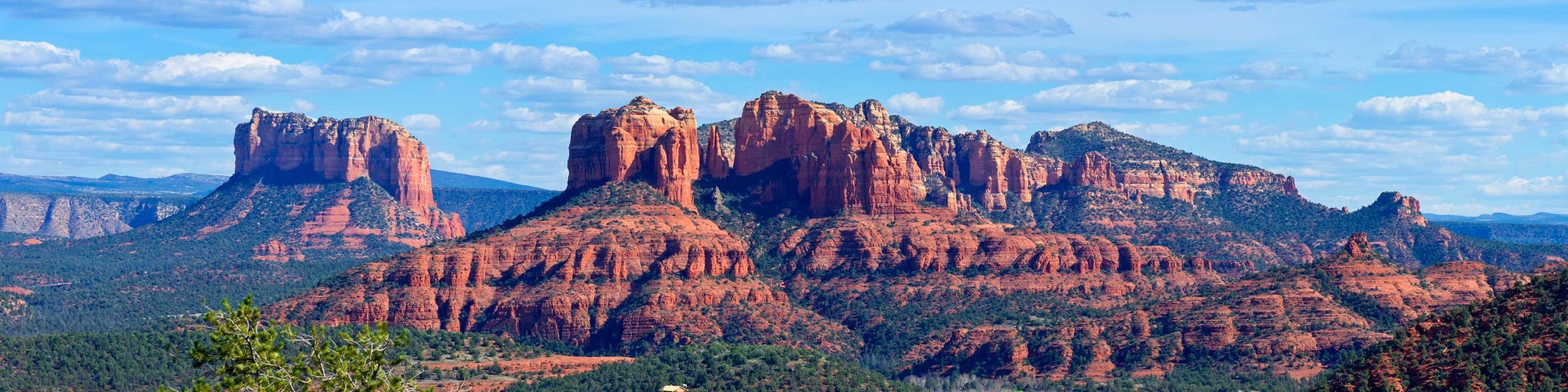
Then we leave Interstate 17 to head north again, because you should not miss a visit to the red rock formations of Sedona. The view from the engine is beautiful, truly phenomenal. Everyone who comes to Sedona wants to see the red rocks for which the region is famous. But not everyone knows that it takes a fairly short walk in Red Rock State Park, just outside the city, to get a spectacular panoramic view of the rust-colored sand formations. Eagle's Nest Trail, for example, first takes the visitor down to Oak Creek and then to the highest point in the park, at 4100 feet, where you can look around in 360 degrees at the red rocks but also at the Mingus Mountain a bit further in the Verde Valley. It is a route of just over three kilometers that is easy to walk. Red Rock State Park has a network of eight kilometers of hiking trails that are interconnected.
Of course you can take a dip in the swimming pool in the hotel in the evening. Fortunately the shops, bars and restaurant are within walking distance of the hotel, and you can walk here if you still have the money.
In this 4-star route you will drive along beautiful good roads, where you will certainly fall from one surprise to the other in Sedona. Take enough water with you!
General information:
Flagstaff is named after the flagpole that an entrepreneurial pioneer put down in 1876. He did that next to his house, in the middle of nowhere. Today, Flagstaff is a town that mainly serves as a base for trips to the Grand Canyon and the other monuments in Northern Arizona.
It is a pleasant and unremarkable town and can be used as a base for the area. Flagstaff is within driving distance of a large number of attractive destinations. In addition to the Grand Canyon are Crater Monument, Wallnut Canyon, Sedona, Fort Verde, Montezuma's Castle and a stretch of Route 66.
The Lowell Observatoy observatory is located in Flagstaff itself. This is one of the most important observatories in America, the place where, for example, the planet Pluto was discovered. The two museums of the city are also very nice. One is dedicated to local history and has the charm of an amateur collection, the other is dedicated to the Indians and is one of the better museums in this area. In downtown you can visit The Black Bean Burrito Bar & Salsa Co. recommend. 12 E. Route 66. We also ate well in the student neighborhood, in the local brewery, the Beaver Street Brewery.


 Links
Links  Usage
Usage Want to download this route?
You can download the route for free without MyRoute-app account. To do so, open the route and click 'save as'. Want to edit this route?
No problem, start by opening the route. Follow the tutorial and create your personal MyRoute-app account. After registration, your trial starts automatically.  Disclaimer
Use of this GPS route is at your own expense and risk. The route has been carefully composed and checked by a MyRoute-app accredited RouteXpert for use on TomTom, Garmin and MyRoute-app Navigation.
Changes may nevertheless have occurred due to changed circumstances, road diversions or seasonal closures. We therefore recommend checking each route before use.
Preferably use the route track in your navigation system. More information about the use of MyRoute-app can be found on the website under 'Community' or 'Academy'.