Day 118 The Ultimate USA road trip Bandon Eureka

This route was brought to you by:
RouteXpert René Plücken (MRA Master)
Last edit: 01-03-2024
 Route Summary
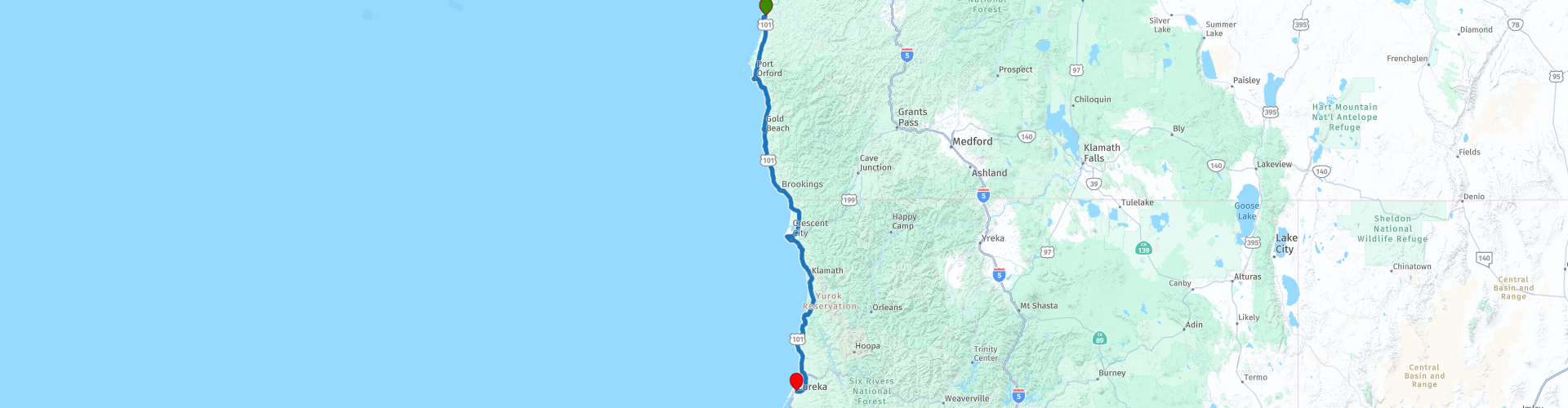
 I have further supplemented the Road Trip with even more special points that you can visit in the USA. Today we drive from Bandon Oregon along the Pacific Coast to Eureka, California. It is a ride of more than 320 kilometers.
We drive on the beautiful US-101, Oregon Pacific Highway to California, this is part of the Pacific Coast Scenic Byway. This is the major north-south US highway that starts in Washington and runs along the western coastline of Oregon to the California border. Along the way you will enjoy beautiful views and there are several sights to visit. I rate this route 5 stars.
 Share this route


Animation

Verdict


Duration
10h 45m

Mode of travel
Car or motorcycle

Distance
322.09 km

Countries

 RouteXpert Review
 Pacific Coast Scenic Byway, US Route 101 or US Highway 101 is a north-south US Highway that runs along the west coast of the United States through the states of California, Oregon and Washington. The first 90 miles to the California state line is the final section of “Oregon Coast Highway No. 9” which has a total length of 363.11 mi (584.37 km).
The southern part of the Byway changes a bit, as it is dominated by rugged cliffs, farms and sandy beaches. This segment features some of the most photographed areas in Oregon. There are a number of beautiful waypoints with a POI included in the route that are a must stop, such as;
• “Face Rock State Scenic Viewpoint”; The rocks and mud flats bordering the park are part of the Oregon Islands National Wildlife Refuge. More than 300 bird species occur in the area. The lookout point's name is derived from the rock island off the coast that has the resemblance of a human face and is part of a Native American legend. Besides the “Face Rock” you can also see the “Cat and Kittens Rock” and the “Cathedral”.
• West Coast Game Park Safari; Zoo enthusiasts can visit the West Coast Game Park Safari, which has become Oregon's largest, fully self-sustaining wildlife attraction, dedicated to reproduction, conservation and education, while serving as a reminder that extinction lasts forever!
• Vist Port Orford Heads State Park; a coastal state park in northwestern Curry County, Oregon, United States, in the city of Port Orford. It was founded in 1976 and is operated by the Oregon Parks and Recreation Department. Located on a bluff above the town, the park has three main hiking trails: the Cove, Tower, and Headland trails. From any of these vantage points (at the right time of year) you can see commercial fishing boats, orcas, gray whales, Steller's sea lions, seabirds, and the California coast. The Headland Trail offers unobstructed views of Cape Blanco to the north and is a popular whale watching spot in the fall. The park is only open during the day. From 1934 to 1970, this site was one of the first U.S. Coast Guard lifeboat stations
• Prehistoric Gardens; Established in 1955 in Port Orford, these gardens contain 23 life-size dinosaur sculptures nestled among the lush foliage of the area's temperate rainforest. The gardens are the work of amateur paleontologist EV "Ernie" Nelson; the site is managed by Nelson's granddaughter. The sculptures are made with a steel frame base and sculpted with mesh-like metal lath and concrete. The largest sculpture is a Brachiosaurus measuring 24 meters long. Signs provide information about each of the dinosaurs represented, as well as plants native to the area. Although the sculptures are anatomically accurate, the paint colors are imaginative and photogenic. A small gift shop sells dinosaur-related merchandise, along with products such as fossils and agates.
• The Isaac Lee Patterson Bridge (Wedderburn Bridge); A nice photo opportunity of this concrete arch bridge that spans the Rogue River is highly recommended. This bridge has strong Art Deco influences. It is a prominent example of the designs of designer Conde McCullough. It was designated a National Historic Civil Engineering Landmark by the American Society of Civil Engineers in 1982. It is part of a series of notable bridges on the Oregon Coast Highway. It was placed on the National Register of Historic Places in 2005.
• The Ship Ashore Resort; At this resort there is a ship on dry land that was built in 1925 in Germany for a New York millionaire. No expense was spared to make this yacht one of the most palatial types ever built. It sailed around the world and many foreign dignitaries, including members of the royal family, sailed on the “Caritas”, the original name of the ship. In 1941, the US government purchased the ship and she was converted for use as a naval ship in World War II. It was stationed in Hawaii until 1946, when the ship was decommissioned. She made several port tours over the next few years, eventually becoming a floating restaurant, gift shop, museum and motel office in the waters off Smith River. In 1965, twelve tractors were hitched to the boat and she was towed a quarter mile to her current resting place along Route 101. The journey took 10 hours, and it is now a prominent landmark in the area. The Ship Ashore motel at this location was the site of a mass shooting in March 1975, Robert Sander murdered seven people in cold blood, apparently for no reason.
• Crescent City Battery Point Lighthouse; Visit the Battery Point Lighthouse and its museum. It has been an active lighthouse since December 10, 1856 and serves as an aid to navigation. It is open to the public for tours, which include a look into the personal quarters of the administrators and their families, and a climb into the light tower. There is furniture and displays of maritime artefacts, photographs and documents. Open from 10am to 4pm but remember that Battery Point Lighthouse is on a tidal island and is only accessible at low tide.
• Trees of Mystery; a park and tourist attraction along US Route 101 (US 101) near the coastal town of Klamath, California. It features interpretive trails through Giant Redwoods and a number of unusual tree formations, many of which can be seen from the Trail of Mysterious Trees. The Trail of Tall Tales features some 50 chainsaw sculptures and carvings that illustrate stories of legendary lumberjack Paul Bunyan and his crew. Trees of Mystery is best known for its 15-meter-high statue of Paul Bunyan and 11-meter-high statue of Bunyan's companion Babe the Blue Ox. An early 1950 brochure called the attraction "Unbelievable but true, the world's largest group of living wonders in nature".
We also drive on the Newton B. Drury Scenic Parkway. These ten miles (16km) will be one of the most beautiful rides of your life. Located in the heart of Prairie Creek State Park, the road takes you through thousands of acres of old-growth redwood forests. There are several parking lots if you want to stop and explore the area, and there are plenty of well-marked trails along the Parkway to stroll through these beautiful woods.
Two locations where you should definitely stop and take photos are the Corkscrew Tree and the Big Tree Wayside. The Corkscrew Tree is a rather special Redwood, because its trunk is intertwined with several other Redwood trees. Because the trunks are twisted together, it appears as if they are screwed together, hence the name of the tree. The tree's massive trunk resembles a wood-clad cathedral spire stretching to the sky above.
Big Tree Wayside is a two minute walk past beautiful redwoods. At the "Big Tree" there is a viewing platform and an interpretive sign. It is estimated that this tree is more than 1,500 years old and towers more than 60 meters above the ground.
The last planned stop before we drive to the end point is Sumêg Village. In the 1990s, Sumêg Village was planned and built by the Yurok people in collaboration with local park staff. It features traditional Yurok family homes, a sweathouse, locker rooms, a redwood canoe and a dance house. The village is used by local Yuroks for educating their youth and sharing their culture with park visitors.
The end point of this scenic drive is in the coastal town of Eureka, partly due to its location on Humboldt Bay, the main port between San Francisco and Coos Bay in the state of Oregon.
In addition, the city functions as the headquarters of several nature reserves in its immediate vicinity. It is centrally located in the region of the sequoia trees. The old town of Eureka itself, the Old Town Historic District with several hundred Victorian homes, is of great architectural importance. One of the most famous Victorian homes is the Queen Anne-style Carson Mansion. A beautiful city to stay. We will spend the night in the beautiful Historic Eagle House Hotel.


 Links
Links  Usage
Usage Want to download this route?
You can download the route for free without MyRoute-app account. To do so, open the route and click 'save as'. Want to edit this route?
No problem, start by opening the route. Follow the tutorial and create your personal MyRoute-app account. After registration, your trial starts automatically.  Disclaimer
Use of this GPS route is at your own expense and risk. The route has been carefully composed and checked by a MyRoute-app accredited RouteXpert for use on TomTom, Garmin and MyRoute-app Navigation.
Changes may nevertheless have occurred due to changed circumstances, road diversions or seasonal closures. We therefore recommend checking each route before use.
Preferably use the route track in your navigation system. More information about the use of MyRoute-app can be found on the website under 'Community' or 'Academy'.

California
About this region
California is a state in the Western United States. It shares a border with Oregon to the north, Nevada and Arizona to the east, and the Mexican state of Baja California to the south. With over 39.5 million residents across a total area of approximately 163,696 square miles (423,970 km2), it is the most populous and the third-largest U.S. state by area. It is also the most populated subnational entity in North America and the 34th most populous in the world. The Greater Los Angeles area and the San Francisco Bay Area are the nation's second and fifth most populous urban regions respectively, with the former having more than 18.7 million residents and the latter having over 9.6 million. Sacramento is the state's capital, while Los Angeles is the most populous city in the state and the second most populous city in the country (after New York City). Los Angeles County is the country's most populous, while San Bernardino County is the largest county by area in the country. San Francisco, which is both a city and a county, is the second most densely populated major city in the country (after New York City) and the fifth most densely populated county in the country, behind four of New York City's five boroughs.
The economy of California, with a gross state product of $3.2 trillion as of 2019, is the largest sub-national economy in the world. If it were a country, it would be the 37th most populous country and the fifth largest economy as of 2020. The Greater Los Angeles area and the San Francisco Bay Area are the nation's second- and third-largest urban economies ($1.0 trillion and $0.5 trillion respectively as of 2020), after the New York metropolitan area ($1.8 trillion). The San Francisco Bay Area Combined Statistical Area had the nation's highest gross domestic product per capita ($106,757) among large primary statistical areas in 2018, and is home to five of the world's ten largest companies by market capitalization and four of the world's ten richest people.Prior to European colonization, California was one of the most culturally and linguistically diverse areas in pre-Columbian North America and contained the highest Native American population density north of what is now Mexico. European exploration in the 16th and 17th centuries led to the colonization of California by the Spanish Empire. In 1804, it was included in Alta California province within the Viceroyalty of New Spain. The area became a part of Mexico in 1821, following its successful war for independence, but was ceded to the United States in 1848 after the Mexican–American War. The western portion of Alta California was then organized and admitted as the 31st state on September 9, 1850, following the Compromise of 1850. The California Gold Rush started in 1848 and led to dramatic social and demographic changes, including large-scale immigration into California, a worldwide economic boom, and the California genocide of indigenous people.
Notable contributions to popular culture, for example in entertainment and sports, have their origins in California. The state also has made noteworthy contributions in the fields of communication, information, innovation, environmentalism, economics, and politics. It is the home of Hollywood, the oldest and largest film industry in the world, which has had a profound effect on global entertainment. It is considered the origin of the hippie counterculture, beach and car culture, and the personal computer, among other innovations. The San Francisco Bay Area and the Greater Los Angeles Area are widely seen as centers of the global technology and entertainment industries, respectively. California's economy is very diverse: 58% of it is based on finance, government, real estate services, technology, and professional, scientific, and technical business services. Although it accounts for only 1.5% of the state's economy, California's agriculture industry has the highest output of any U.S. state. California's ports and harbors handle about a third of all U.S. imports, most originating in Pacific Rim international trade.
The state's extremely diverse geography ranges from the Pacific Coast and metropolitan areas in the west to the Sierra Nevada mountains in the east, and from the redwood and Douglas fir forests in the northwest to the Mojave Desert in the southeast. The Central Valley, a major agricultural area, dominates the state's center. Although California is well known for its warm Mediterranean climate and monsoon seasonal weather, the large size of the state results in climates that vary from moist temperate rainforest in the north to arid desert in the interior, as well as snowy alpine in the mountains. All these factors lead to an enormous demand for water. Over time, droughts and wildfires have increased in frequency and become less seasonal and more year-round, further straining California's water security.
Read more on Wikipedia
The economy of California, with a gross state product of $3.2 trillion as of 2019, is the largest sub-national economy in the world. If it were a country, it would be the 37th most populous country and the fifth largest economy as of 2020. The Greater Los Angeles area and the San Francisco Bay Area are the nation's second- and third-largest urban economies ($1.0 trillion and $0.5 trillion respectively as of 2020), after the New York metropolitan area ($1.8 trillion). The San Francisco Bay Area Combined Statistical Area had the nation's highest gross domestic product per capita ($106,757) among large primary statistical areas in 2018, and is home to five of the world's ten largest companies by market capitalization and four of the world's ten richest people.Prior to European colonization, California was one of the most culturally and linguistically diverse areas in pre-Columbian North America and contained the highest Native American population density north of what is now Mexico. European exploration in the 16th and 17th centuries led to the colonization of California by the Spanish Empire. In 1804, it was included in Alta California province within the Viceroyalty of New Spain. The area became a part of Mexico in 1821, following its successful war for independence, but was ceded to the United States in 1848 after the Mexican–American War. The western portion of Alta California was then organized and admitted as the 31st state on September 9, 1850, following the Compromise of 1850. The California Gold Rush started in 1848 and led to dramatic social and demographic changes, including large-scale immigration into California, a worldwide economic boom, and the California genocide of indigenous people.
Notable contributions to popular culture, for example in entertainment and sports, have their origins in California. The state also has made noteworthy contributions in the fields of communication, information, innovation, environmentalism, economics, and politics. It is the home of Hollywood, the oldest and largest film industry in the world, which has had a profound effect on global entertainment. It is considered the origin of the hippie counterculture, beach and car culture, and the personal computer, among other innovations. The San Francisco Bay Area and the Greater Los Angeles Area are widely seen as centers of the global technology and entertainment industries, respectively. California's economy is very diverse: 58% of it is based on finance, government, real estate services, technology, and professional, scientific, and technical business services. Although it accounts for only 1.5% of the state's economy, California's agriculture industry has the highest output of any U.S. state. California's ports and harbors handle about a third of all U.S. imports, most originating in Pacific Rim international trade.
The state's extremely diverse geography ranges from the Pacific Coast and metropolitan areas in the west to the Sierra Nevada mountains in the east, and from the redwood and Douglas fir forests in the northwest to the Mojave Desert in the southeast. The Central Valley, a major agricultural area, dominates the state's center. Although California is well known for its warm Mediterranean climate and monsoon seasonal weather, the large size of the state results in climates that vary from moist temperate rainforest in the north to arid desert in the interior, as well as snowy alpine in the mountains. All these factors lead to an enormous demand for water. Over time, droughts and wildfires have increased in frequency and become less seasonal and more year-round, further straining California's water security.
View region
 Statistics
  43
43Amount of RX reviews (California)
 29627
29627Amount of visitors (California)
 768
768Amount of downloads (California)
 Route Collections in this region
 Car or motorcycle tour through the western US
This collection contains all 15 routes driven by MRA Goldmember André ter Schegget during his three-week tour through the west of America.
The places to visit, the attractions and beautiful photo spots are nicely marked on the routes. The routes have been fully checked and made equal for the Garmin and the TomTom. Enjoy this wonderful trip and let us know how it was! Enjoy and stay safe!
Order of the tour:
Route 01: from Los Angeles and via Pacific Coast Highway to Solvang
Route 02: Solvang to Monterey / Pacific Grove
Route 03A: Monterey to San Francisco
Route 03B: if you are by car instead of the motorcycle, as motorcycles are not allowed on the 17 Mile Drive: from Monterey to the 17 Mile Drive and further to San Francisco
Route 04: from San Francisco via Nappa and Eldorado National Forrest to Topaz Lake
Route 05: from Topaz Lake via Bodie and Yosemite to Oakhurst
Route 06: from Oakhurst via Kings Canyon NP and Sequoia NP and Giant Forest to Exeter
Route 07: Exeter via Isabella Lake and Ridgecrest to Death Valley
Route 08: from Death Valley via Valley Of Fire to Mesquite
Route 09: from Mesquite via Zion NP and Dixie NF to Hatch
Route 10: Hatch via Bryce Canyon to Page
Route 11: from Page via Grand Canyon to Williams
Route 12: from Williams via Seligman and Route 66 to Kingman and via Hoover Dam to Las Vegas
Route 13: from Las Vegas via Oatman and Lake Havasu to Parker
Route 14: from Parker via Joshua Tree to Rancho Mirage
Route 15: Rancho Mirage via Palm Springs to Santa Monica
View Route Collection
The 10 most downloaded routes in the USA from RouteXpert Hans van de Ven
Hello and welcome to this collection of the Top 10 MyRoute app downloaded routes in USA.
There will be a great new event to be announced soon, where all these routes can be driven.
Download them all now and place them in a new "Top 10" folder, so that you always have them at hand.
If you are going to drive one of these routes in the meantime, track them with the MRA Mobile App or with MRA Navigation. Take some photos (moments) along the way as these will come in handy.
Create a travelogue of your Top 10 driven routes and add the recorded track to it.
There will also be some great prizes on offer, so keep an eye on the MRA-RouteXperts page and your mail.
The 10 routes are:
1. D13 Estes Park Denver
2. D03 Chadron Custer
3. D01 Pigeon Forge round trip through the Smokey Mountains
4. D08 Kalispell Sandpoint
5. D10 Colville Wenatchee
6. D09 Sandpoint Colville
7. D04 Custer Wall
8. D11 Wenatchee Seattle
9. D08 Cody Yellowstone NP
10.R13 San Francisco Monterey
View Route Collection