Day 119 The Ultimate USA road trip Eureka Fort Bragg

This route was brought to you by:
RouteXpert René Plücken (MRA Master)
Last edit: 29-02-2024
 Route Summary
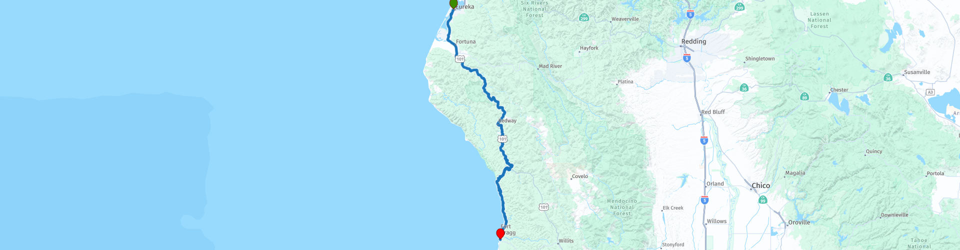
 I have further supplemented the Road Trip with even more special points that you can visit in the USA. Today we drive from Eureka along the Pacific Coast to Fort Bragg. It is a ride of 225 kilometers.
We drive on the beautiful US-101, Pacific Coast Highway in California, this is part of the Pacific Coast Scenic Byway. This is the major north-south US highway that starts in Washington and runs along the western coastline of Oregon to the California border. Along the way you will enjoy beautiful views and there are several sights to visit and very beautiful viewpoints. I rate this route 5 stars.
 Share this route


Animation

Verdict


Duration
10h 2m

Mode of travel
Car or motorcycle

Distance
226.64 km

Countries

 RouteXpert Review
 The first stop is after a few minutes' drive in Eureka, we visit it
Fort Humboldt State Historic Park. The park offers a rich historical experience for visitors. The park's displays provide insight into the former US Army fort that was operational from 1853 to 1870. In addition, the park interprets the interactions between European Americans and Native Americans during the same period. Visitors can also explore exhibits showcasing logging equipment and the region's local narrow-gauge history.
Fort Humboldt State Historic Park's collection includes a variety of historical artifacts. Visitors can see trains, logging equipment and a fully functional Steam Donkey engine. One of the highlights of the collection is an authentic Native American dugout canoe, which provides a glimpse into the region's indigenous history.
Fort Humboldt State Historic Park is located on a bluff, with beautiful views of Humboldt Bay. The park also houses the regional headquarters of the California State Parks system on the North Coast, adding to its importance in the region.
After about 50 kilometers we leave US-101 to drive the amazing “Avenue of the Giants”.
This famous road, the most beautiful route between the redwoods, is also called the most beautiful forest route in the world. Lined with giant sequoias, the 31-mile Avenue, parallel to Highway 101, is largely flat with beautiful sweeping curves and passes remote forest hamlets, campsites, picnic areas and access points to the Eel River, a federally designated Wild & Scenic waterway with idyllic swimming, fishing and paddling spots. There are numerous trailheads along the Avenue, all leading into the magical redwood forest.
Visit Founders Groove. Located just off the famous Avenue of the Giants, this incredible redwood forest is home to some of the tallest trees in the world. At the end of the loop is the beautiful fallen Dyerville Giant. The giant sequoia once stood 360 feet tall and was considered the tallest tree in the park before its fall in 1991. The fall of the redwood to the ground moved the Earth so much that it was recorded on a nearby seismograph and a local resident, who heard the impact. half a mile away he thought a train had crashed. Today you can walk the entire length of the tree and be amazed by the enormous root system on beautiful display. Dyerville Giant Facts: 110 meters high 5.5 meters diameter 16 meters circumference Possibly 2000 years old.
You can visit the Humboldt Redwoods State Park Visitor Center. There are numerous visual and hands-on educational exhibits, a theater, library, gift shop, and friendly volunteer staff to answer questions about the park and surrounding area.
Visit the Shrine Drive Thru Tree, ride your motorcycle through a redwood tree or over a fallen redwood tree. The Shrine Drive Thru Tree has been attracting visitors for years. Great place to take some beautiful photos. There is a $10 fee to drive through the tree.
We return to US-101 and follow the course of the South Fork Eel River, a river in the northern part of the US state of California, which rises near Laytonville and flows north for approximately 169 km to its confluence with the Eel River near Weott. Some major tributaries of the largely free-flowing river include Tenmile Creek, the East Branch South Fork Eel River near Benbow, and Hollow Tree Creek. The river covers an area of 1,780 km2 and is said to be the most important river supporting coho salmon in the state. We will cross the river several times via one of thirty-five bridges, some are beautiful constructions and if it is safe you can stop to take a photo.
Visit Confusion Hill, a small park with some fun attractions, including the historic Mountain Train Ride, which is a 30-minute train ride through redwoods, brown oaks, pine and madrone trees to the hilltop and back. You will travel on 1¼ miles of 20 gauge track. We use a unique Alpine switchback system to get up the hill. The engineer will tell you about some of the unique features of the coast redwoods. There is also an interesting collection of historic logging equipment on display as you make the loop around the top of the hill.
At the town of Legett we leave US-101 again to take the great Shoreline Highway to Fort Bragg, we drive through the forested mountains back to the coast. On the last 70 kilometers of this route there are numerous viewpoints where you can enjoy the beautiful cliffs and coastline of the Pacific Ocean. Depending on the season and time of year, you will be able to enjoy a beautiful sunset.
The end point of this beautiful ride is in Fort Bragg, where there are several hotels and resorts to stay overnight, the Noyo Harbor Inn is recommended. This historic hotel sits majestically above the Noyo riverbank, against sweeping views of the endless forests, the flowing river, the harbor overlooking the Pacific Ocean. It features cozy and luxurious rooms, a tranquil spa and a beautiful restaurant and bar where you can dine both indoors and outdoors. The property offers visitors access to gardens, walking trails, the harbor, local beaches and state parks.


 Links
Links  Usage
Usage Want to download this route?
You can download the route for free without MyRoute-app account. To do so, open the route and click 'save as'. Want to edit this route?
No problem, start by opening the route. Follow the tutorial and create your personal MyRoute-app account. After registration, your trial starts automatically.  Disclaimer
Use of this GPS route is at your own expense and risk. The route has been carefully composed and checked by a MyRoute-app accredited RouteXpert for use on TomTom, Garmin and MyRoute-app Navigation.
Changes may nevertheless have occurred due to changed circumstances, road diversions or seasonal closures. We therefore recommend checking each route before use.
Preferably use the route track in your navigation system. More information about the use of MyRoute-app can be found on the website under 'Community' or 'Academy'.

California
About this region
California is a state in the Western United States. It shares a border with Oregon to the north, Nevada and Arizona to the east, and the Mexican state of Baja California to the south. With over 39.5 million residents across a total area of approximately 163,696 square miles (423,970 km2), it is the most populous and the third-largest U.S. state by area. It is also the most populated subnational entity in North America and the 34th most populous in the world. The Greater Los Angeles area and the San Francisco Bay Area are the nation's second and fifth most populous urban regions respectively, with the former having more than 18.7 million residents and the latter having over 9.6 million. Sacramento is the state's capital, while Los Angeles is the most populous city in the state and the second most populous city in the country (after New York City). Los Angeles County is the country's most populous, while San Bernardino County is the largest county by area in the country. San Francisco, which is both a city and a county, is the second most densely populated major city in the country (after New York City) and the fifth most densely populated county in the country, behind four of New York City's five boroughs.
The economy of California, with a gross state product of $3.2 trillion as of 2019, is the largest sub-national economy in the world. If it were a country, it would be the 37th most populous country and the fifth largest economy as of 2020. The Greater Los Angeles area and the San Francisco Bay Area are the nation's second- and third-largest urban economies ($1.0 trillion and $0.5 trillion respectively as of 2020), after the New York metropolitan area ($1.8 trillion). The San Francisco Bay Area Combined Statistical Area had the nation's highest gross domestic product per capita ($106,757) among large primary statistical areas in 2018, and is home to five of the world's ten largest companies by market capitalization and four of the world's ten richest people.Prior to European colonization, California was one of the most culturally and linguistically diverse areas in pre-Columbian North America and contained the highest Native American population density north of what is now Mexico. European exploration in the 16th and 17th centuries led to the colonization of California by the Spanish Empire. In 1804, it was included in Alta California province within the Viceroyalty of New Spain. The area became a part of Mexico in 1821, following its successful war for independence, but was ceded to the United States in 1848 after the Mexican–American War. The western portion of Alta California was then organized and admitted as the 31st state on September 9, 1850, following the Compromise of 1850. The California Gold Rush started in 1848 and led to dramatic social and demographic changes, including large-scale immigration into California, a worldwide economic boom, and the California genocide of indigenous people.
Notable contributions to popular culture, for example in entertainment and sports, have their origins in California. The state also has made noteworthy contributions in the fields of communication, information, innovation, environmentalism, economics, and politics. It is the home of Hollywood, the oldest and largest film industry in the world, which has had a profound effect on global entertainment. It is considered the origin of the hippie counterculture, beach and car culture, and the personal computer, among other innovations. The San Francisco Bay Area and the Greater Los Angeles Area are widely seen as centers of the global technology and entertainment industries, respectively. California's economy is very diverse: 58% of it is based on finance, government, real estate services, technology, and professional, scientific, and technical business services. Although it accounts for only 1.5% of the state's economy, California's agriculture industry has the highest output of any U.S. state. California's ports and harbors handle about a third of all U.S. imports, most originating in Pacific Rim international trade.
The state's extremely diverse geography ranges from the Pacific Coast and metropolitan areas in the west to the Sierra Nevada mountains in the east, and from the redwood and Douglas fir forests in the northwest to the Mojave Desert in the southeast. The Central Valley, a major agricultural area, dominates the state's center. Although California is well known for its warm Mediterranean climate and monsoon seasonal weather, the large size of the state results in climates that vary from moist temperate rainforest in the north to arid desert in the interior, as well as snowy alpine in the mountains. All these factors lead to an enormous demand for water. Over time, droughts and wildfires have increased in frequency and become less seasonal and more year-round, further straining California's water security.
Read more on Wikipedia
The economy of California, with a gross state product of $3.2 trillion as of 2019, is the largest sub-national economy in the world. If it were a country, it would be the 37th most populous country and the fifth largest economy as of 2020. The Greater Los Angeles area and the San Francisco Bay Area are the nation's second- and third-largest urban economies ($1.0 trillion and $0.5 trillion respectively as of 2020), after the New York metropolitan area ($1.8 trillion). The San Francisco Bay Area Combined Statistical Area had the nation's highest gross domestic product per capita ($106,757) among large primary statistical areas in 2018, and is home to five of the world's ten largest companies by market capitalization and four of the world's ten richest people.Prior to European colonization, California was one of the most culturally and linguistically diverse areas in pre-Columbian North America and contained the highest Native American population density north of what is now Mexico. European exploration in the 16th and 17th centuries led to the colonization of California by the Spanish Empire. In 1804, it was included in Alta California province within the Viceroyalty of New Spain. The area became a part of Mexico in 1821, following its successful war for independence, but was ceded to the United States in 1848 after the Mexican–American War. The western portion of Alta California was then organized and admitted as the 31st state on September 9, 1850, following the Compromise of 1850. The California Gold Rush started in 1848 and led to dramatic social and demographic changes, including large-scale immigration into California, a worldwide economic boom, and the California genocide of indigenous people.
Notable contributions to popular culture, for example in entertainment and sports, have their origins in California. The state also has made noteworthy contributions in the fields of communication, information, innovation, environmentalism, economics, and politics. It is the home of Hollywood, the oldest and largest film industry in the world, which has had a profound effect on global entertainment. It is considered the origin of the hippie counterculture, beach and car culture, and the personal computer, among other innovations. The San Francisco Bay Area and the Greater Los Angeles Area are widely seen as centers of the global technology and entertainment industries, respectively. California's economy is very diverse: 58% of it is based on finance, government, real estate services, technology, and professional, scientific, and technical business services. Although it accounts for only 1.5% of the state's economy, California's agriculture industry has the highest output of any U.S. state. California's ports and harbors handle about a third of all U.S. imports, most originating in Pacific Rim international trade.
The state's extremely diverse geography ranges from the Pacific Coast and metropolitan areas in the west to the Sierra Nevada mountains in the east, and from the redwood and Douglas fir forests in the northwest to the Mojave Desert in the southeast. The Central Valley, a major agricultural area, dominates the state's center. Although California is well known for its warm Mediterranean climate and monsoon seasonal weather, the large size of the state results in climates that vary from moist temperate rainforest in the north to arid desert in the interior, as well as snowy alpine in the mountains. All these factors lead to an enormous demand for water. Over time, droughts and wildfires have increased in frequency and become less seasonal and more year-round, further straining California's water security.
View region
 Statistics
  43
43Amount of RX reviews (California)
 29619
29619Amount of visitors (California)
 768
768Amount of downloads (California)
 Route Collections in this region
 Car or motorcycle tour through the western US
This collection contains all 15 routes driven by MRA Goldmember André ter Schegget during his three-week tour through the west of America.
The places to visit, the attractions and beautiful photo spots are nicely marked on the routes. The routes have been fully checked and made equal for the Garmin and the TomTom. Enjoy this wonderful trip and let us know how it was! Enjoy and stay safe!
Order of the tour:
Route 01: from Los Angeles and via Pacific Coast Highway to Solvang
Route 02: Solvang to Monterey / Pacific Grove
Route 03A: Monterey to San Francisco
Route 03B: if you are by car instead of the motorcycle, as motorcycles are not allowed on the 17 Mile Drive: from Monterey to the 17 Mile Drive and further to San Francisco
Route 04: from San Francisco via Nappa and Eldorado National Forrest to Topaz Lake
Route 05: from Topaz Lake via Bodie and Yosemite to Oakhurst
Route 06: from Oakhurst via Kings Canyon NP and Sequoia NP and Giant Forest to Exeter
Route 07: Exeter via Isabella Lake and Ridgecrest to Death Valley
Route 08: from Death Valley via Valley Of Fire to Mesquite
Route 09: from Mesquite via Zion NP and Dixie NF to Hatch
Route 10: Hatch via Bryce Canyon to Page
Route 11: from Page via Grand Canyon to Williams
Route 12: from Williams via Seligman and Route 66 to Kingman and via Hoover Dam to Las Vegas
Route 13: from Las Vegas via Oatman and Lake Havasu to Parker
Route 14: from Parker via Joshua Tree to Rancho Mirage
Route 15: Rancho Mirage via Palm Springs to Santa Monica
View Route Collection
The 10 most downloaded routes in the USA from RouteXpert Hans van de Ven
Hello and welcome to this collection of the Top 10 MyRoute app downloaded routes in USA.
There will be a great new event to be announced soon, where all these routes can be driven.
Download them all now and place them in a new "Top 10" folder, so that you always have them at hand.
If you are going to drive one of these routes in the meantime, track them with the MRA Mobile App or with MRA Navigation. Take some photos (moments) along the way as these will come in handy.
Create a travelogue of your Top 10 driven routes and add the recorded track to it.
There will also be some great prizes on offer, so keep an eye on the MRA-RouteXperts page and your mail.
The 10 routes are:
1. D13 Estes Park Denver
2. D03 Chadron Custer
3. D01 Pigeon Forge round trip through the Smokey Mountains
4. D08 Kalispell Sandpoint
5. D10 Colville Wenatchee
6. D09 Sandpoint Colville
7. D04 Custer Wall
8. D11 Wenatchee Seattle
9. D08 Cody Yellowstone NP
10.R13 San Francisco Monterey
View Route Collection