Day 122 The Ultimate USA road trip San Francisco Carmel

This route was brought to you by:
RouteXpert René Plücken (MRA Master)
Last edit: 31-03-2024
 Route Summary
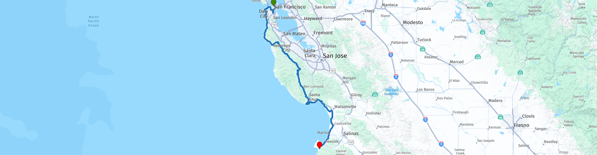
 I have further supplemented the Road Trip with even more special points that you can visit in the USA. Today we drive from San Francisco to Carmel by the Sea.
We drive on beautiful winding roads with sometimes a stretch of highway. Along the way you will enjoy beautiful views, beautiful nature, there are several sights to visit and many beautiful viewpoints. I rate this route 4 stars.
 Share this route


Animation

Verdict


Duration
9h 13m

Mode of travel
Car or motorcycle

Distance
257.05 km

Countries

 RouteXpert Review
 From the starting point “Fisherman's Wharf”, we drive via the Embarcadero to the Presidio of San Francisco (originally El Presidio Real de San Francisco or the Royal Fort of Saint Francis).
Presidio is a park and former U.S. Army post on the northern tip of the San Francisco Peninsula near the Golden Gate Bridge. Part of the Golden Gate National Recreation Area, the Presidio had been a fortress since September 17, 1776, when New Spain established the Presidio to gain a foothold in Alta California and San Francisco Bay. It passed to Mexico in 1820, which in turn passed it to the United States in 1848. As part of a military reduction program under the 1988 Base Realignment and Closure (BRAC) process, Congress voted to end Presidio's status as an active military installation of the U.S. Army. On October 1, 1994, it was transferred to the National Park Service, ending 219 years of military use and beginning the next phase of mixed commercial and public use.
The park has many wooded areas, hills and scenic vistas overlooking the Golden Gate Bridge, San Francisco Bay and the Pacific Ocean. It was recognized as a California Historic Landmark in 1933 and as a National Historic Landmark in 1962.
In the park you can visit the Walt Disney Family Museum, this museum tells the story of the man behind perhaps the largest media company in the world. The complete life story of Walt Disney, the man behind Mickey Mouse and Donald Duck, can be seen in the Walt Disney Family Museum. How did he start drawing, how did he end up working with Mickey, and why did he open an amusement park when you were in your 50s? You will find the answers to those questions here. Especially fun for people who are fans of Disney.
We drive to Lands End via the Legion of Honor. Legion of Honor, formally known as the California Palace of the Legion of Honor, is an art museum in San Francisco, located in Lincoln Park. The park is also home to the statue of Joan of Arc, one of four replicas cast around 1922 from an original 1915 sculpture by Anna Vaughn Hyatt Huntington in New York City's Riverside Park.
At Lands End we visit the Cliff House, Camera Obscura and the Seal Rock. Enjoy views of Seal Rock and visit the Camera Obscura behind the Cliff House, a device based on a design by Leonardo da Vinci that produces 360-degree live spectacular views of the waters around Seal Rock.
We drive on the Great Highway past Ocean Beach, a beautiful long and wide beach on the west coast of San Francisco, located on the Pacific Ocean. The beach is part of the Golden Gate National Recreation Area and is popular with surfers. The beach is adjacent to Golden Gate Park and the Richmond District and Sunset District neighborhoods. The Great Highway runs for approximately 3.5 miles along Ocean Beach.
At the end of the Great Highway, you can visit the San Francisco Zoo, a 40-acre zoo and public institution managed by the nonprofit San Francisco Zoological Society. As of 2016, the zoo housed more than a thousand individual animals, representing more than 250 species. It is known as the birthplace of Koko the gorilla and, from 1974 to 2016, home to Elly, the oldest black rhino in North America.
The Great Highway becomes State Route 35 (SR 35), commonly known as Skyline Boulevard, which is a two-lane state highway for most of its length. This scenic road runs along the ridge of the Santa Cruz Mountains and because of its high elevation it is one of the few places on the southern part of the San Francisco Peninsula where San Francisco Bay and the Pacific Ocean are both visible at the same time. It also offers scenic views of the Silicon Valley metropolitan area.
There are several stops along Skyline Boulevard to enjoy the views, such as at the World War II Devil's Bunker, one of six military structures at Devil's Slide. The station became outdated and was abandoned in 1949. The land was purchased by a private owner in 1983 and all buildings except the bunker were removed. The bunker is located 4.5 meters above the ground on a rock and is covered in graffiti. It is located on private property with limited public access, but is easily accessible. It's a short walk from the parking lot.
Point Montara Lighthouse, founded in February 1875, is also a great stop. The current tower was first built in 1881 in Wellfleet, Massachusetts as the Mayo Beach Lighthouse. In 1925, the cast iron tower was moved to Yerba Buena, and in 1928 moved and rebuilt into the Point Montara Light station, where it stands today. The lighthouse is not open to the public and was added to the National Register of Historic Places in 1991.
There are also many vineyards along the route that you can visit for a tour or tasting, such as the Thomas Fogarty Winery, one of the Santa Cruz Mountain's most respected and historic producers. The winery dates back to 1978 when Dr. Thomas Fogarty, a Stanford Cardiovascular Surgeon and world-renowned inventor, planted the vineyards that are now the Winery Estate. Reservation required.
Skyline Boulevard connects to Highway 9. Enjoy the drive on this amazing highway that winds through the majestic redwood forests of the San Lorenzo Valley along the San Lorenzo River and logging-era railroad tracks. You'll pass the Henry Cowell Redwoods, beautiful towns like Ben Lomond, where bakeries and cafes are tucked next to antique and home goods stores, Felton and finally Santa Cruz.
We deviate briefly from the route to visit the Felton Covered Bridge in Felton. Built in 1892, this covered bridge over the San Lorenzo River in Felton uses a brown truss construction system and is approximately 80 feet long. The bridge became a California Historic Landmark in 1957, was placed on the National Register of Historic Places in 1973, and underwent major restoration in 1987 after being damaged during a storm in the winter of 1982. The bridge is considered the largest covered bridge in the world. The bridge is only accessible to pedestrians.
Lunch is planned in Santa Cruz where you can choose from several good restaurants and fast food chains. After lunch we visit Natural Bridges State Beach in Santa Cruz. The park features a natural bridge over part of the beach and a eucalyptus forest, which provides a habitat for monarch butterflies. During monarch butterfly migration (October to early February), up to 150,000 monarch butterflies can be seen.
At National Bridges State Beach Park, Westcliff Drive starts, enjoy the ride along this three-mile boardwalk with breathtaking views of the Monterey Bay and connecting Santa Cruz's most prominent landmarks. You'll drive past ice plant-covered cliffs and scenic beach coves with plenty of places to stop and take beautiful photos. A good example is the iconic Mark Abbott Lighthouse, which houses the Santa Cruz Surfing Museum. From this scenic point you can marvel at surfers at the legendary Steamer Lane surf spot. Continuing on, you'll pass beautiful Monterey Bay filled with paddleboarders making their way along the Wharf, colorful umbrellas in the sand of Main and Cowell Beaches, and the dazzling attractions of the Santa Cruz Beach Boardwalk.
The Santa Cruz Beach Boardwalk is a classic seaside amusement park, located on a beautiful sandy beach in a friendly seaside town. The Boardwalk features more than 40 attractions, including two National Historic Landmarks: the world-famous 1924 Giant Dipper wooden roller coaster and the beautiful 1911 Looff Carousel, plus many thrill rides, fun kiddie rides, casual dining, gift shops, games, indoor arcades and miniature golf . Definitely a nice stop to consider.
From Santa Cruz it is about an 80 kilometer drive along Monterey Bay to the terminus in Carmel By The Sea, known for its many attractions and beautiful white sandy beach. Carmel Beach is a favorite of visitors and locals alike. There are many hotels and resorts to stay overnight. Enjoy your stay in this beautiful seaside resort.


 Links
Links  Usage
Usage Want to download this route?
You can download the route for free without MyRoute-app account. To do so, open the route and click 'save as'. Want to edit this route?
No problem, start by opening the route. Follow the tutorial and create your personal MyRoute-app account. After registration, your trial starts automatically.  Disclaimer
Use of this GPS route is at your own expense and risk. The route has been carefully composed and checked by a MyRoute-app accredited RouteXpert for use on TomTom, Garmin and MyRoute-app Navigation.
Changes may nevertheless have occurred due to changed circumstances, road diversions or seasonal closures. We therefore recommend checking each route before use.
Preferably use the route track in your navigation system. More information about the use of MyRoute-app can be found on the website under 'Community' or 'Academy'.

California
About this region
California is a state in the Western United States. It shares a border with Oregon to the north, Nevada and Arizona to the east, and the Mexican state of Baja California to the south. With over 39.5 million residents across a total area of approximately 163,696 square miles (423,970 km2), it is the most populous and the third-largest U.S. state by area. It is also the most populated subnational entity in North America and the 34th most populous in the world. The Greater Los Angeles area and the San Francisco Bay Area are the nation's second and fifth most populous urban regions respectively, with the former having more than 18.7 million residents and the latter having over 9.6 million. Sacramento is the state's capital, while Los Angeles is the most populous city in the state and the second most populous city in the country (after New York City). Los Angeles County is the country's most populous, while San Bernardino County is the largest county by area in the country. San Francisco, which is both a city and a county, is the second most densely populated major city in the country (after New York City) and the fifth most densely populated county in the country, behind four of New York City's five boroughs.
The economy of California, with a gross state product of $3.2 trillion as of 2019, is the largest sub-national economy in the world. If it were a country, it would be the 37th most populous country and the fifth largest economy as of 2020. The Greater Los Angeles area and the San Francisco Bay Area are the nation's second- and third-largest urban economies ($1.0 trillion and $0.5 trillion respectively as of 2020), after the New York metropolitan area ($1.8 trillion). The San Francisco Bay Area Combined Statistical Area had the nation's highest gross domestic product per capita ($106,757) among large primary statistical areas in 2018, and is home to five of the world's ten largest companies by market capitalization and four of the world's ten richest people.Prior to European colonization, California was one of the most culturally and linguistically diverse areas in pre-Columbian North America and contained the highest Native American population density north of what is now Mexico. European exploration in the 16th and 17th centuries led to the colonization of California by the Spanish Empire. In 1804, it was included in Alta California province within the Viceroyalty of New Spain. The area became a part of Mexico in 1821, following its successful war for independence, but was ceded to the United States in 1848 after the Mexican–American War. The western portion of Alta California was then organized and admitted as the 31st state on September 9, 1850, following the Compromise of 1850. The California Gold Rush started in 1848 and led to dramatic social and demographic changes, including large-scale immigration into California, a worldwide economic boom, and the California genocide of indigenous people.
Notable contributions to popular culture, for example in entertainment and sports, have their origins in California. The state also has made noteworthy contributions in the fields of communication, information, innovation, environmentalism, economics, and politics. It is the home of Hollywood, the oldest and largest film industry in the world, which has had a profound effect on global entertainment. It is considered the origin of the hippie counterculture, beach and car culture, and the personal computer, among other innovations. The San Francisco Bay Area and the Greater Los Angeles Area are widely seen as centers of the global technology and entertainment industries, respectively. California's economy is very diverse: 58% of it is based on finance, government, real estate services, technology, and professional, scientific, and technical business services. Although it accounts for only 1.5% of the state's economy, California's agriculture industry has the highest output of any U.S. state. California's ports and harbors handle about a third of all U.S. imports, most originating in Pacific Rim international trade.
The state's extremely diverse geography ranges from the Pacific Coast and metropolitan areas in the west to the Sierra Nevada mountains in the east, and from the redwood and Douglas fir forests in the northwest to the Mojave Desert in the southeast. The Central Valley, a major agricultural area, dominates the state's center. Although California is well known for its warm Mediterranean climate and monsoon seasonal weather, the large size of the state results in climates that vary from moist temperate rainforest in the north to arid desert in the interior, as well as snowy alpine in the mountains. All these factors lead to an enormous demand for water. Over time, droughts and wildfires have increased in frequency and become less seasonal and more year-round, further straining California's water security.
Read more on Wikipedia
The economy of California, with a gross state product of $3.2 trillion as of 2019, is the largest sub-national economy in the world. If it were a country, it would be the 37th most populous country and the fifth largest economy as of 2020. The Greater Los Angeles area and the San Francisco Bay Area are the nation's second- and third-largest urban economies ($1.0 trillion and $0.5 trillion respectively as of 2020), after the New York metropolitan area ($1.8 trillion). The San Francisco Bay Area Combined Statistical Area had the nation's highest gross domestic product per capita ($106,757) among large primary statistical areas in 2018, and is home to five of the world's ten largest companies by market capitalization and four of the world's ten richest people.Prior to European colonization, California was one of the most culturally and linguistically diverse areas in pre-Columbian North America and contained the highest Native American population density north of what is now Mexico. European exploration in the 16th and 17th centuries led to the colonization of California by the Spanish Empire. In 1804, it was included in Alta California province within the Viceroyalty of New Spain. The area became a part of Mexico in 1821, following its successful war for independence, but was ceded to the United States in 1848 after the Mexican–American War. The western portion of Alta California was then organized and admitted as the 31st state on September 9, 1850, following the Compromise of 1850. The California Gold Rush started in 1848 and led to dramatic social and demographic changes, including large-scale immigration into California, a worldwide economic boom, and the California genocide of indigenous people.
Notable contributions to popular culture, for example in entertainment and sports, have their origins in California. The state also has made noteworthy contributions in the fields of communication, information, innovation, environmentalism, economics, and politics. It is the home of Hollywood, the oldest and largest film industry in the world, which has had a profound effect on global entertainment. It is considered the origin of the hippie counterculture, beach and car culture, and the personal computer, among other innovations. The San Francisco Bay Area and the Greater Los Angeles Area are widely seen as centers of the global technology and entertainment industries, respectively. California's economy is very diverse: 58% of it is based on finance, government, real estate services, technology, and professional, scientific, and technical business services. Although it accounts for only 1.5% of the state's economy, California's agriculture industry has the highest output of any U.S. state. California's ports and harbors handle about a third of all U.S. imports, most originating in Pacific Rim international trade.
The state's extremely diverse geography ranges from the Pacific Coast and metropolitan areas in the west to the Sierra Nevada mountains in the east, and from the redwood and Douglas fir forests in the northwest to the Mojave Desert in the southeast. The Central Valley, a major agricultural area, dominates the state's center. Although California is well known for its warm Mediterranean climate and monsoon seasonal weather, the large size of the state results in climates that vary from moist temperate rainforest in the north to arid desert in the interior, as well as snowy alpine in the mountains. All these factors lead to an enormous demand for water. Over time, droughts and wildfires have increased in frequency and become less seasonal and more year-round, further straining California's water security.
View region
 Statistics
  43
43Amount of RX reviews (California)
 29619
29619Amount of visitors (California)
 768
768Amount of downloads (California)
 Route Collections in this region
 Car or motorcycle tour through the western US
This collection contains all 15 routes driven by MRA Goldmember André ter Schegget during his three-week tour through the west of America.
The places to visit, the attractions and beautiful photo spots are nicely marked on the routes. The routes have been fully checked and made equal for the Garmin and the TomTom. Enjoy this wonderful trip and let us know how it was! Enjoy and stay safe!
Order of the tour:
Route 01: from Los Angeles and via Pacific Coast Highway to Solvang
Route 02: Solvang to Monterey / Pacific Grove
Route 03A: Monterey to San Francisco
Route 03B: if you are by car instead of the motorcycle, as motorcycles are not allowed on the 17 Mile Drive: from Monterey to the 17 Mile Drive and further to San Francisco
Route 04: from San Francisco via Nappa and Eldorado National Forrest to Topaz Lake
Route 05: from Topaz Lake via Bodie and Yosemite to Oakhurst
Route 06: from Oakhurst via Kings Canyon NP and Sequoia NP and Giant Forest to Exeter
Route 07: Exeter via Isabella Lake and Ridgecrest to Death Valley
Route 08: from Death Valley via Valley Of Fire to Mesquite
Route 09: from Mesquite via Zion NP and Dixie NF to Hatch
Route 10: Hatch via Bryce Canyon to Page
Route 11: from Page via Grand Canyon to Williams
Route 12: from Williams via Seligman and Route 66 to Kingman and via Hoover Dam to Las Vegas
Route 13: from Las Vegas via Oatman and Lake Havasu to Parker
Route 14: from Parker via Joshua Tree to Rancho Mirage
Route 15: Rancho Mirage via Palm Springs to Santa Monica
View Route Collection
The 10 most downloaded routes in the USA from RouteXpert Hans van de Ven
Hello and welcome to this collection of the Top 10 MyRoute app downloaded routes in USA.
There will be a great new event to be announced soon, where all these routes can be driven.
Download them all now and place them in a new "Top 10" folder, so that you always have them at hand.
If you are going to drive one of these routes in the meantime, track them with the MRA Mobile App or with MRA Navigation. Take some photos (moments) along the way as these will come in handy.
Create a travelogue of your Top 10 driven routes and add the recorded track to it.
There will also be some great prizes on offer, so keep an eye on the MRA-RouteXperts page and your mail.
The 10 routes are:
1. D13 Estes Park Denver
2. D03 Chadron Custer
3. D01 Pigeon Forge round trip through the Smokey Mountains
4. D08 Kalispell Sandpoint
5. D10 Colville Wenatchee
6. D09 Sandpoint Colville
7. D04 Custer Wall
8. D11 Wenatchee Seattle
9. D08 Cody Yellowstone NP
10.R13 San Francisco Monterey
View Route Collection