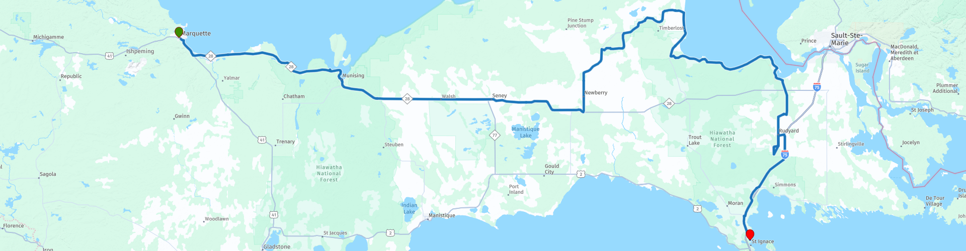
Marquette to St Ignace

This route was brought to you by:
RouteXpert Nick Carthew - (MRA Master)
Last edit: 29-10-2021
 Route Summary
 This route travels along the southerly shore of Lake Superior then through the Hiawatha National Forest. The scenery for the day is lakes and forest with a lunch stop in Paradise!
This route is unhurried, laid back and scenic so it gets 4**** stars from me.
 Share this route


Animation

Verdict


Duration
8h 55m

Mode of travel
Car or motorcycle

Distance
368.96 km

Countries

 RouteXpert Review
 This route starts by following the southern shore of Lake Superior, or Gitche Gumee for those that have read 'The Song of Hiawatha' poem written in 1855 by Henry Wadsworth Longfellow.
By the shores of Gitche Gumee,
By the shining Big-Sea-Water,
Stood the wigwam of Nokomis,
Daughter of the Moon, Nokomis.
Gitche Gumee is also an opening line to one of my favourite songs: Wreck Of The Edmund Fitzgerald - by Gordon Lightfoot
The legend lives on from the Chippewa on down
of the big lake they called Gitche Gumee.
The lake, it is said, never gives up her dead
When the skies of November turn gloomy.
There are many photo opportunities along the shore of Gitche Gumee so make sure your camera is fully charged. Taking into account the photo stops, you'll be in the small town of Christmas in 1 hour.
Situated just 4-1/2 miles from Munising on M-28, this town is in all reality the town of the Christmas season. During the winter, it's a scenic Christmas wonderland. In the summer, the agate beaches of Lake Superior, the roadside santas, stores and signs all welcome you to Christmas, Michigan, a "must" on your Upper Michigan travels.
On the outskirts of town, and before stopping for a coffee you can visit Bay Furnace Park in Christmas, (a National Forest Campground and Picnic Area) that was originally the town of Onota where a huge stone blast fumace was built in 1869 to make iron. Ships carrying iron ore docked at the long pier and the iron was smelted in the forge and melted into "pigs". The "Pig Iron" was then shipped to the lower Great Lakes. In 1877 the town, also known as "Bay Furnace", was destroyed by fire leaving only the iron smelting kiln.
There are more viewpoints worthy of a photo as you leave Christmas and don't miss the Munising Front Range Lighthouse at Munising RP 13.
Leaving Munising takes you away from Gitche Gumee and into the Hiawatha National Forest.
Located in Michigan's wild and scenic Upper Peninsula, the Hiawatha National Forest's dramatic shorelines lie nestled up to Lakes Superior, Huron and Michigan -- three of the five great lakes. There are more than 2000 miles (3200 km) of forest roads and trails designated open for motorised use, this route only uses surfaced roads. The road through the forest is long and arrow straight, kick back, relax and enjoy the trees, and trees, and treeeeees. 90 minutes later and you'll arrive at a crossroad where you'll turn left for Paradise! There are fast food restaurants for coffee and gas stations for fuel here.
Heading in a north east direction through more forested lands, you'll arrive at Tahquamenon Upper Falls. It really is worth stopping here for yet more photos. The Tahquamenon Lower Falls are a few miles further on and then you'll arrive back on the shore of Lake Gitche Gumee in Paradise! What a name.
Founded in 1925, Paradise is surrounded by state and national forests and its main business is tourism. It is considered one of the gateways to the Tahquamenon Falls. You can take the coast road up to Whitefish Point to visit the lighthouse and Great Lakes Shipwreck Museum, the have the bell from the SS Edmund Fitzgerald. It'll take about an hour round trip to visit Whitefish Point. I have suggested Paradise as a lunch stop, there are a selection of eateries allowing you to tell your friends that you dined out in Paradise just after Christmas!
You travel around the coast again with more photo stops until you reach RP 30 Point Iroquois Lighthouse.
From birch bark canoes to giant ore freighters, this unique point of land has influenced travel for centuries. Lake Superior, the deepest and coldest of the Great Lakes, was especially hazardous in this area because of dangerous weather conditions and the high volume of traffic on the water from ships leaving and approaching the Sault Ste. Marie locks. Even with the aid of the light and fog horn at Point Iroquois, ships occasionally foundered in the passage. Sixteen crewmen lost their lives in the freezing lake when the Steamer Myron went down in 1919 during one of the infamous "Storms of November". Finding the bodies as they washed ashore, lightkeeper Elmer Byrnes took them to an undertaker in the nearby town of Brimley. The undertaker would pay $10 apiece for "floaters".
Climb the spiral staircase to the top of the 65-foot light tower. Observe the beauty of Canada just 3 miles away across the lake, and the ocean-going freighters as they come and go through the Soo Locks.
There's a coffee house a couple of miles down the road and then a couple more miles and you'll be heading south and it's time to say goodbye Gitche Gumee.
The road south is through a mixture of forested and agricultural land, and again it has an unhurried feel making it a relaxing ride. In just 1 hour, you'll be arriving at your hotel for the night in Saint Ignace on the shore of your third Great Lake - Lake Huron.


 Links
Links  Usage
Usage Want to download this route?
You can download the route for free without MyRoute-app account. To do so, open the route and click 'save as'. Want to edit this route?
No problem, start by opening the route. Follow the tutorial and create your personal MyRoute-app account. After registration, your trial starts automatically.  Disclaimer
Use of this GPS route is at your own expense and risk. The route has been carefully composed and checked by a MyRoute-app accredited RouteXpert for use on TomTom, Garmin and MyRoute-app Navigation.
Changes may nevertheless have occurred due to changed circumstances, road diversions or seasonal closures. We therefore recommend checking each route before use.
Preferably use the route track in your navigation system. More information about the use of MyRoute-app can be found on the website under 'Community' or 'Academy'.
Michigan
About this region
Michigan is a state in the Great Lakes region of the upper Midwestern United States. Its name derives from a gallicized variant of the original Ojibwe word ᒥᓯᑲᒥ (mishigami), meaning 'large water' or 'large lake'. With a population of nearly 10.1 million and a total area of nearly 97,000 sq mi (250,000 km2), Michigan is the 10th-largest state by population, the 11th-largest by area, and the largest east of the Mississippi River. Its capital is Lansing, and its largest city is Detroit. Metro Detroit is among the nation's most populous and largest metropolitan economies.
Michigan is the only state to consist of two peninsulas. The Lower Peninsula is shaped like a mitten. The Upper Peninsula (often called "the U.P.") is separated from the Lower Peninsula by the Straits of Mackinac, a five-mile (8 km) channel that joins Lake Huron to Lake Michigan. The Mackinac Bridge connects the peninsulas. Michigan has the longest freshwater coastline of any political subdivision in the world, being bordered by four of the five Great Lakes, plus Lake St. Clair. It also has 64,980 inland lakes and ponds.The area was first occupied by a succession of Native American tribes over thousands of years. Inhabited by natives, Métis, and French explorers in the 17th century, it was claimed as part of the New France colony. After France's defeat in the French and Indian War in 1762, the region came under British rule. Britain ceded the territory to the newly independent United States after Britain's defeat in the American Revolutionary War. The area was part of the larger Northwest Territory until 1800, when western Michigan became part of the Indiana Territory. Michigan Territory was formed in 1805, but some of the northern border with Canada was not agreed upon until after the War of 1812. Michigan was admitted into the Union in 1837 as the 26th state, a free one. It soon became an important center of industry and trade in the Great Lakes region and a popular émigré destination in the late 19th and early 20th centuries; immigration from many European countries to Michigan was also the busiest at that time, especially for those who emigrated from Finland, Macedonia and the Netherlands.Although Michigan developed a diverse economy, it is widely known as the center of the U.S. automotive industry, which developed as a major economic force in the early 20th century. It is home to the country's three major automobile companies (whose headquarters are all in Metro Detroit). While sparsely populated, the Upper Peninsula is important for tourism due to its abundance of natural resources, while the Lower Peninsula is a center of manufacturing, forestry, agriculture, services, and high-tech industry.
Read more on Wikipedia
Michigan is the only state to consist of two peninsulas. The Lower Peninsula is shaped like a mitten. The Upper Peninsula (often called "the U.P.") is separated from the Lower Peninsula by the Straits of Mackinac, a five-mile (8 km) channel that joins Lake Huron to Lake Michigan. The Mackinac Bridge connects the peninsulas. Michigan has the longest freshwater coastline of any political subdivision in the world, being bordered by four of the five Great Lakes, plus Lake St. Clair. It also has 64,980 inland lakes and ponds.The area was first occupied by a succession of Native American tribes over thousands of years. Inhabited by natives, Métis, and French explorers in the 17th century, it was claimed as part of the New France colony. After France's defeat in the French and Indian War in 1762, the region came under British rule. Britain ceded the territory to the newly independent United States after Britain's defeat in the American Revolutionary War. The area was part of the larger Northwest Territory until 1800, when western Michigan became part of the Indiana Territory. Michigan Territory was formed in 1805, but some of the northern border with Canada was not agreed upon until after the War of 1812. Michigan was admitted into the Union in 1837 as the 26th state, a free one. It soon became an important center of industry and trade in the Great Lakes region and a popular émigré destination in the late 19th and early 20th centuries; immigration from many European countries to Michigan was also the busiest at that time, especially for those who emigrated from Finland, Macedonia and the Netherlands.Although Michigan developed a diverse economy, it is widely known as the center of the U.S. automotive industry, which developed as a major economic force in the early 20th century. It is home to the country's three major automobile companies (whose headquarters are all in Metro Detroit). While sparsely populated, the Upper Peninsula is important for tourism due to its abundance of natural resources, while the Lower Peninsula is a center of manufacturing, forestry, agriculture, services, and high-tech industry.
View region
 Statistics
  9
9Amount of RX reviews (Michigan)
 11316
11316Amount of visitors (Michigan)
 154
154Amount of downloads (Michigan)
 Route Collections in this region
 The ultimate Great Lakes Tour
This is a tour from Chicago to Staten Island, New York visiting the 5 Great Lakes of North America.
Starting from EagleRider Motorcycle rental at Illinois Harley-Davidson in Chicago and ending at EagleRider Motorcycle rental in Staten Island.
The Ultimate Great Lakes tour is a route through the United States and Canada to scenic destinations along Lakes Michigan, Superior, Huron, Erie and Ontario.
What are the Great Lakes? The Great Lakes are a series of five interconnected freshwater lakes located on the border of the United States and Canada. They are the largest group of freshwater lakes in the world by area and have sea-like characteristics such as rolling waves, strong currents, miles of sandy and rocky beaches, and distant horizons. This tour of 8 routes includes places to stop for coffee, lunch and overnight hotels. It also visits well known historic and scenic sites along the way mostly avoiding major highways. I have suggested 2 nights at Lake Superior and 2 nights at Niagara Falls, making this a 10 day tour, but of course, that is up to you. The scenery and landscapes are breathtaking and each day is different to the next. Please enjoy.
View Route Collection
Trans Canada Highway
The Trans-Canada Highway (TCH) or Trans-Canadian Highway is a system of highways that cover all 10 provinces of Canada.
The Federal and Provincial Highways System that now forms the TCH were authorized by the Trans-Canada Highway Act of 1948 and opened in 1962. It was completed in 1971. The total length of the TCH is 7821 km.
Contrary to the American Interstate Highway System, the TCH does not consist of an unambiguous network of motorways, but forms a network of restricted access highways and other main routes that are more akin to the Dutch provincial roads. The route is indicated by a green shield with a white maple leaf.
The numbering of the roads that are part of the TCH is the domain of the provinces. Only the western provinces have aligned their numbering and the TCH has the designation Highway 1 there.
The main route of the TCH starts in Victoria in British Columbia and runs via Calgary and Regina to Winnipeg. From Winnipeg the route leads to Kenora in Ontario, after which several branches pass through Ontario to Ottawa.
Further east, the route passes through the province of Quebec via Montreal and Quebec, among others, to Moncton, New Brunswick. Then the TCH continues east through Nova Scotia, where a branch (via the Confederation Bridge) leads to Prince Edward Island. Another section runs down to the sea in the port city of Sydney, where a ferry service leaves for Channel-Port aux Basques on the island of Newfoundland. From there the route continues for more than 900 km to the provincial capital of St. John's, in the extreme southeast of the island.
We not only drive the TCH, but will take the rural roads as much as possible, because only Highway driving is too boring and Canada has many beautiful roads through its beautiful landscape. You drive through all provinces and through very varied and scenic landscapes, from the Rockies in the West, the Central Prairies to the Eastern Maritimes and the Northern Forest.
The riding season is generally April through October with longer seasons on the west coast and southern Ontario. Provide good all season clothing or bring rain gear, depending on the province and the season the weather can change and you may be surprised by a rain or even a snow or hail shower, so be prepared.
In Canada the metric system is used, so speeds are indicated in Km / h. A helmet requirement (DOT approved) applies throughout Canada.
You will see many wildlife throughout Canada. This varies from province to province, such as deer, buffalos, moose, caribou, wolves, pumas, bears, mountain goats, sheep, lynx, coyotes, foxes, raccoons, badgers, various rodents and all kinds of birds. Even if it is very tempting to stop for a photo, don't do it, it can be very dangerous.
The routes described in this review sometimes deviate from the Trans Canada Highway, bringing the total length to 9,300 kilometers. The routes are made so that you drive through the beautiful parts of Canada with truly beautiful panoramas and beautiful sights to visit, this differs from museums, parks to historical points. The routes are not too long so there is time to stop for photos and sights along the way. You can also choose to arrange and combine the stages differently or to add other routes to shorten or extend your journey. The routes are marked with a rating in stars, some routes are less challenging or interesting but are necessary to drive to the next point, which is why they often have a lower rating.
In the route description you will find more details about the routes and the points of interest along the way. These points and also hotels, restaurants, petrol stations etc. are indicated with a POI and sometimes also with a Route point. In the description you will also find links to interesting sites and to the routes that connect to that day.
The described routes are;
Day 01 TCH Victory to Nanaimo
Day 02 TCH Nanaimo to Hope
Day 03 TCH Hope to Kamloops
Day 04 TCH Kamloops to Revelstoke
Day 05 TCH Revelstoke to Lake Louise
Day 06 TCH Lake Louise to Calgary
Day 07 TCH Calgary to Medicine Hat
Day 08 TCH Medicine Hat to Moose Jaw
Day 09 TCH Moose Jaw to Regina
Day 10 TCH Regina to Brandon
Day 11 TCH Brandon to Winnipeg
Day 12 TCH Winnipeg to Kenora
Day 13 TCH Kenora to Ignace
Day 14 TCH Ignace to Thunder Bay
Day 15 TCH Thunder Bay to Marathon
Day 16 Thunder Bay to Wawa
Day 17 TCH Wawa to Sault Ste Marie
Day 18 TCH Sault Ste Marie to Espanola
Day 19 TCH Espanola to Mattawa
Day 20 TCH Mattawa to Ottawa
Day 21 TCH Ottawa to Montreal
Day 22 TCH Montreal to Quebec
Day 23 TCH Quebec to Riviere du Loup
Day 24 TCH Riviere du Loup to Grand Falls
Day 25 TCH Grand Falls to Fredericton
Day 26 TCH Fredericton to Moncton
Day 27 TCH Moncton to Charlottetown
Day 28 TCH Charlottetown to Truro
Day 29 TCH Truro to North Sydney
Day 30 TCH North Sydney to Corner Brook
Day 31 TCH Corner Brook to Grand Falls
Day 32 TCH Grand Falls to Clarenville
Day 33 TCH Clarenville to St John.
Have fun reading the reviews and planning your next road trip.
If you have driven this trip, I am very curious about your feedback!
View Route Collection