Day 109 The Ultimate USA road trip St Mary Bonners Ferry

This route was brought to you by:
RouteXpert René Plücken (MRA Master)
Last edit: 25-01-2024
 Route Summary
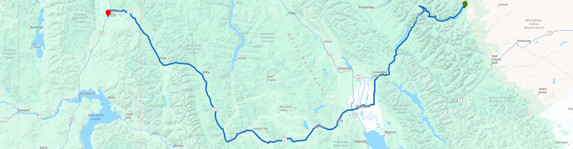
 I have further supplemented the Road Trip with even more special points that you can visit in the USA. Today we drive from St Mary in Montana to Bonners Ferry in Idaho. It is a ride of more than 355 kilometers.
We drive on the “Going to the Sun Highway” through Glacier National Park and we drive through the Kootenai National Forest. Many stops are planned along the route, not at museums or other sights, but at beautiful viewpoints with truly spectacular views. I rate this route 4 stars.
 Share this route


Animation

Verdict


Duration
8h 43m

Mode of travel
Car or motorcycle

Distance
357.50 km

Countries

 RouteXpert Review
 Glacier National Park is a beautiful unspoilt nature reserve with glaciers, rugged mountain peaks, many lakes, waterfalls and forests. There are many animals in the park such as beavers, otters, mountain goats, sheep and elk and Glacier National Park is also one of the last parks in America where grizzly bears can be found. So pay close attention, because the animals also cross the road.
The park is a busy tourist park and tourists are often driven through the park on antique red buses to the most beautiful sightseeing spots. The park has a number of fun and popular hiking trails. One of the most famous places to hike is on the Many Glacier. Here you have beautiful views of snow-capped mountain peaks, clear lakes and rugged mountains within a short distance. This area is also popular because this is where most grizzlies are spotted. Keep a close eye on the warnings from rangers! The Many Glacier is not located along the route, if you still want to visit it it is advisable to plan an extra day in St Mary, the Many Glacier is a 35 kilometer drive from St Mary. At the Many Glacier it is also possible to spend the night in a hotel or campsite. Good planning and timely reservations for accommodation and restaurants are important for a longer stay in Glacier National Park.
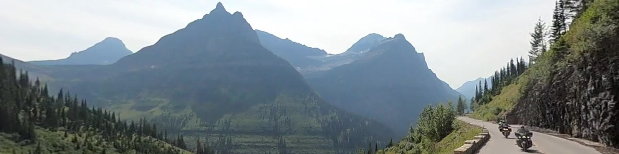
We drive the "Going-to-the-Sun-Road", this is a picturesque mountain road in the Rocky Mountains, which is only open in the summer months (late June to early October). It is a toll road and the cost is $30 for a motorcycle and $20 per person. Also known as the “Sun Road,” this scenic road is the only road that crosses the park, crossing the “Continental Divide” through Logan Pass at an elevation of 7,026 feet, the highest point on the road. Construction of the road began in 1921 and was officially opened to traffic on July 15, 1933. Parts of the road are carved into steep rocks. The route shortened the travel time through the mountains from a few days to a few hours. The road is the first to be registered in the following categories: “National Historic Place”, “National Historic Landmark” and “Historic Civil Engineering Landmark”. The road is approximately 80 km (50 mi) long and spans the width of the park between the eastern and western entrances to the park.
The road is named after the mountain “Going-to-the-Sun,” which dominates the eastern view beyond Logan Pass. A Native American legend tells of the deity “Sour Spirit” who came from the sun to teach the Blackfeet the basics of hunting. While returning to the sun, an image of “Sour Spirit” was placed on the mountain as inspiration for the Blackfeet. Another story suggests that a late 19th century Euro-American explorer provided the mountain's name and legend.
There are several options along the route to stop at viewpoints where you can enjoy spectacular views. We drive from the east, where the prairies and wetlands slowly transition to the mountains. Our first stop is at a viewpoint over the beautiful lake “St Mary Lake”. The second stop at “Rising Sun Picnic Area” is only a 5-minute drive away, this is a beautiful place with great views of the mountains and “St Mary Lake”, if you leave early you can see a beautiful sunrise here.
The next stop is at the “Wild Goose Island” viewpoint, which offers stunning panoramic views of the beautiful peaks surrounding Saint Mary Lake, with “Wild Goose Island” as the centerpiece. The island owes its name to an Indian story of two young lovers who sought refuge there. Their pursuers followed them to the island and were almost upon them. The Great Spirit took pity on them and turned them into geese so that they could fly away and live their lives together in peace. A second viewpoint to see the island from a different perspective is about a 3-minute drive away.
For hiking enthusiasts, it is recommended to stop at the “St. Mary Falls”. It is about a 1½ hour (3.1 miles/5 km) walk to the falls. There is a terrace where you have a nice view and can take some pictures. There are two viewpoints along the route where you have a breathtaking view of the Jackson Glacier.
Before we drive up Logan Pass we stop at the Logan Pass Visitor Center, which is located at the highest point (2025 meters) that you can reach by motorcycle or car. At Logan Pass, “Reynolds Mountain” and “Clements Mountain” tower above the wildflower fields of beautiful color. There are hiking trails here for enthusiasts. Here you can also spot wildlife such as mountain goats, bighorn sheep and the occasional grizzly bear trudging through the meadows.
Driving further west you will pass a number of beautiful points such as;
• The Oberlin Bend Viewpoint. This viewpoint is a great place to see mountain goats and other subalpine wildlife. There is a walking path and a boardwalk,
• The Big Bend lookout offers great views of “Mount Oberlin”,
• The “Weeping Wall,” a geological formation along Going-to-the-Sun Road in Glacier National Park, is a natural waterfall that seeps from the side of Haystack Butte and the Garden Wall and is fed by meltwater runoff. Be careful, the road can be slippery here.
• Haystack Falls and Bird Woman Falls are two large waterfalls that you can see from the lookouts.
• The “Red Rocks” are red rocks in McDonald Creek that are part of the Grinnell Formation, a pile of slightly altered sedimentary rocks up to 2,500 feet thick. Iron oxide (rust) in the rocks provides the red hue.
• The “Trail of the Cedars”, is a 0.6 mile/0.97 km walking trail, it is paved and has a raised boardwalk in some parts. Some of the visible cedars are more than 80 feet tall. The trail splits into two parts: one runs in a loop, while the other continues to Avalanche Lake, which can be reached after a 2 mile/3.2 km hike with an elevation gain of 490 ft/150 meters. In the middle of the half loop there is a beautiful waterfall in colorful rocks.
At the west entrance we stop at Lake McDonald. This is the largest lake in Glacier National Park and you can plan lunch here. This is also a popular point to watch the breathtaking sunset in the evening.
The next part of this beautiful route takes us through the Kootenai National Forest, a national forest located in the far northwestern part of Montana and the most northeastern part of Idaho, along the Canada-US border. Of the 2.2 million acres (8,900 km2), less than 3 percent is in the state of Idaho. It is a beautiful route through a densely forested area, with only a stop planned at the “Kootenai Falls & Swinging Bridge”, the largest undammed waterfall in the state and one of the largest waterfalls in the US. The falls are accessible via a footpath from the car park next to the highway. Historically a sacred site for the local Kootenai tribe, the falls became a popular tourist destination in the 2010s thanks to the “Kootenai Falls Swinging Bridge” downstream. The bridge was built in the 1930s by the Civilian Conservation Corps to assist with the U.S. Forest Service's firefighting efforts.
After crossing the state border, this beautiful day ends in Bonners Ferry. The larger of two cities in and the county seat of Boundary County, Idaho. When gold was discovered in the East Kootenais of British Columbia in 1863, thousands of prospectors from across the West headed north on a route that became known as the Wildhorse Trail. Edwin Bonner, a merchant from Walla Walla, Washington, established a ferry in 1864 where the trail crossed the wide Kootenai River. In 1875, Richard Fry and his Sinixt wife, Justine Su-steel Fry, leased the business, but the location retained the original founder's name and later became the town of Bonners Ferry.


 Links
Links  Usage
Usage Want to download this route?
You can download the route for free without MyRoute-app account. To do so, open the route and click 'save as'. Want to edit this route?
No problem, start by opening the route. Follow the tutorial and create your personal MyRoute-app account. After registration, your trial starts automatically.  Disclaimer
Use of this GPS route is at your own expense and risk. The route has been carefully composed and checked by a MyRoute-app accredited RouteXpert for use on TomTom, Garmin and MyRoute-app Navigation.
Changes may nevertheless have occurred due to changed circumstances, road diversions or seasonal closures. We therefore recommend checking each route before use.
Preferably use the route track in your navigation system. More information about the use of MyRoute-app can be found on the website under 'Community' or 'Academy'.