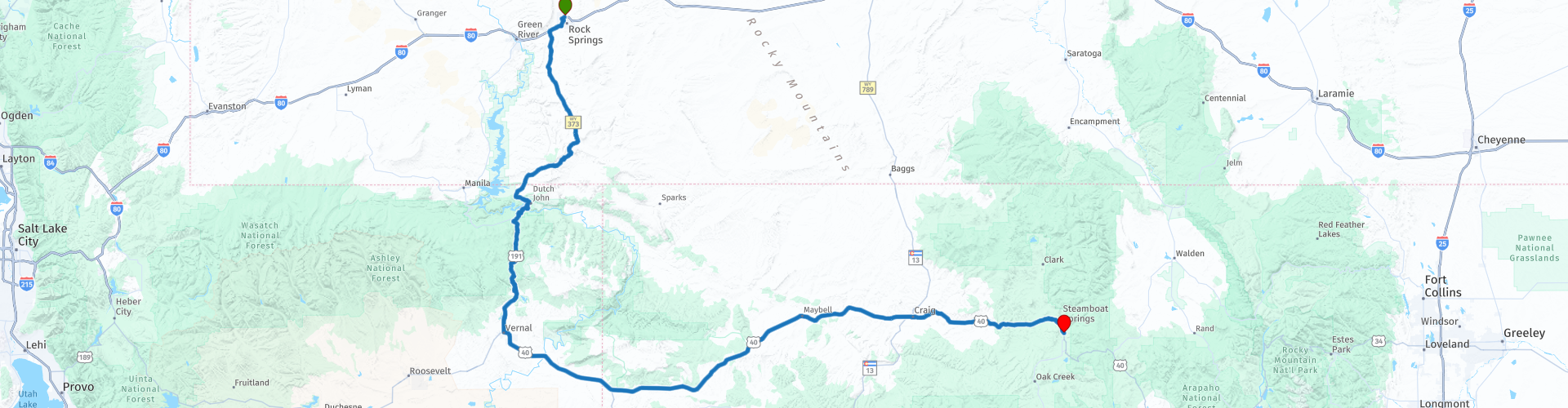
D11 Rock Springs Steamboat Springs

This route was brought to you by:
RouteXpert Hans van de Ven (Mr.MRA)
Last edit: 27-12-2019
 Route Summary
 The roads are good, the mountains high and the views wide and beautiful.
Starting point: Best Western Outlaw Inn.
End point: The Steamboat Hotel.
The route has been made the same for TomTom, Garmin and MyRoute-app Navigation users.
Thanks to Richard & Lisa for the information!
 Share this route


Animation

Verdict


Duration
5h 12m

Mode of travel
Car or motorcycle

Distance
443.47 km

Countries

 RouteXpert Review
 We leave Rock Springs early, we are constantly driving above 1,400 meters today, but first we have to refuel and do some shopping at the Wallmart, so that we have some goodies for on the way at one of the many stops to take photos. As the 1st you come across a viewpoint where you have a nice overview on a 4x4 terrain, if you're lucky they are driving there and you can stop for a few photos.
The next stops are at places where you have a beautiful view over the valley, so take some unforgettable pictures.
After a little less than 95 KM you will leave Wyoming and enter Utah. The history of Utah differs considerably from that of the other states. Before the arrival of Europeans to the New World, the area was populated by Indian tribes such as the Uintah, Ouray and Utes, after whom the state is named. On July 24, 1847, the first Mormon settlers arrived in the area, far removed from other American settlements at that time. The region then belonged to Mexico, which after a war in 1848 had to cede to the United States. The settlers founded hundreds of settlements in an effort to secure land and resources for themselves. In addition, they came into conflict with Indians who traditionally populated these areas.
Only on January 4, 1896, after having been Utah for a long time, did Utah formally become the 45th state of the United States. Local leaders had been arguing for this for more than forty years, but had repeatedly encountered resistance from the federal government, which demanded, among other things, that polygamy be abolished.
One of the beaches during the Normandy Invasion in World War II, called Utah Beach, is named after this state.
The next stop is at the Flaming Gorge Dam, The Flaming Gorge Reservoir is a 146 km long reservoir created by the construction of the Flaming Gorge Dam on the Green River between 1958 and 1964. The water surface reaches a maximum height of 1840 m above sea level. The reservoir contains a maximum of 4.6 km³ of water. A little further at the Flaming Gorge Resort, you have the opportunity to eat, drink or refuel. In the meantime we drive through the Ashley National Forest. This forest with its 1,382,346 hectares of vast forests, lakes and mountains, with heights ranging from 6,000 to 13,500 feet, is wonderful to drive through, enjoying with a capital letter.
We make a short stop in Vernal and then continue to the Dinosaur National Monument, Dinosaurs once roamed here. Their fantastic remains are still visibly embedded in the rocks. Today, the mountains, desert and untamed rivers that flow into deep gorges support a range of life. Petroglyphs point to earlier cultures. Later, among others, outlaws found shelter here. We continue our way and stop again to eat and refuel in Maybell. Between the mountains we finally reach Steamboat Springs where after we have refueled we move into the hotel and let the experiences of this day pass by again.
In this 4-star route you drive on beautiful good roads, a stop at the Dinosaur National Monument is a must.
History:
The Yampa Valley was the hunting ground of the Ute Indians for hundreds of years. The Yampatika Ute and Arapaho tribes also visited the area because of the mineral or 'medicinal' sources that were considered sacred places for physical and spiritual healing.
The name Steamboat Springs probably originated around the beginning of the 19th century, when French furriers thought they heard the squeaking sound of a steamboat's steam engine. The sound turned out to be a natural mineral source, called the Steamboat Spring.
In 1874, James Crawford ventured into the Yampa Valley in search of a living environment. Impressed by the mineral water of the region, he built a hut near the current Iron Spring. Crawford spent a few of his winters in Boulder, Colorado, where he persuaded several prominent businessmen to join him in Steamboat Springs.
By 1885, five other families had settled in the area, including a newspaper man, James Hoyle, who brought his printing press to publish the Steamboat Pilot that same year. The area started to develop slowly, but increased slightly when a sawmill was established in 1883.
In 1900 it became a city, with James Crawford as the first mayor. In 1902 the city had 3 hotels, 3 stables, 3 banks, 4 general stores, 2 meat markets and other businesses, including the Steamboat Springs Service Company. This company was the first electricity company in the community.


 Links
Links  Usage
Usage Want to download this route?
You can download the route for free without MyRoute-app account. To do so, open the route and click 'save as'. Want to edit this route?
No problem, start by opening the route. Follow the tutorial and create your personal MyRoute-app account. After registration, your trial starts automatically.  Disclaimer
Use of this GPS route is at your own expense and risk. The route has been carefully composed and checked by a MyRoute-app accredited RouteXpert for use on TomTom, Garmin and MyRoute-app Navigation.
Changes may nevertheless have occurred due to changed circumstances, road diversions or seasonal closures. We therefore recommend checking each route before use.
Preferably use the route track in your navigation system. More information about the use of MyRoute-app can be found on the website under 'Community' or 'Academy'.

Utah
About this region
Utah ( YOO-tah, YOO-taw) is a state in the Mountain West subregion of the Western United States. It is bordered by Colorado to the east, Wyoming to the northeast, Idaho to the north, Arizona to the south and Nevada to the west. It also touches a corner of New Mexico in the southeast. Of the fifty U.S. states, Utah is the 13th-largest by area; with a population over three million, it is the 30th-most-populous and 11th-least-densely populated. Urban development is mostly concentrated in two areas: the Wasatch Front in the north-central part of the state, which is home to roughly two-thirds of the population and includes the capital city, Salt Lake City; and Washington County in the southwest, with more than 170,000 residents. Most of the western half of Utah lies in the Great Basin.
Utah has been inhabited for thousands of years by various indigenous groups such as the ancient Puebloans, Navajo and Ute. The Spanish were the first Europeans to arrive in the mid-16th century, though the region's difficult geography and harsh climate made it a peripheral part of New Spain and later Mexico. Even while it was Mexican territory, many of Utah's earliest settlers were American, particularly Mormons fleeing marginalization and persecution from the United States. Following the Mexican–American War in 1848, the region was annexed by the U.S., becoming part of the Utah Territory, which included what is now Colorado and Nevada. Disputes between the dominant Mormon community and the federal government delayed Utah's admission as a state; only after the outlawing of polygamy was it admitted in 1896 as the 45th.
Slightly over half of all Utahns are Mormons, the vast majority of whom are members of The Church of Jesus Christ of Latter-day Saints (LDS Church), which has its world headquarters in Salt Lake City; Utah is the only state where a majority of the population belongs to a single church. The LDS Church greatly influences Utahn culture, politics, and daily life, though since the 1990s the state has become more religiously diverse as well as secular.
Utah has a highly diversified economy, with major sectors including transportation, education, information technology and research, government services, mining, and tourism. Utah has been one of the fastest growing states since 2000, with the 2020 U.S. Census confirming the fastest population growth in the nation since 2010. St. George was the fastest-growing metropolitan area in the United States from 2000 to 2005. Utah ranks among the overall best states in metrics such as healthcare, governance, education, and infrastructure. It has the 14th-highest median average income and the least income inequality of any U.S. state. A 2012 Gallup national survey found Utah overall to be the "best state to live in the future" based on 13 forward-looking measurements including various economic, lifestyle, and health-related outlook metrics.
Read more on Wikipedia
Utah has been inhabited for thousands of years by various indigenous groups such as the ancient Puebloans, Navajo and Ute. The Spanish were the first Europeans to arrive in the mid-16th century, though the region's difficult geography and harsh climate made it a peripheral part of New Spain and later Mexico. Even while it was Mexican territory, many of Utah's earliest settlers were American, particularly Mormons fleeing marginalization and persecution from the United States. Following the Mexican–American War in 1848, the region was annexed by the U.S., becoming part of the Utah Territory, which included what is now Colorado and Nevada. Disputes between the dominant Mormon community and the federal government delayed Utah's admission as a state; only after the outlawing of polygamy was it admitted in 1896 as the 45th.
Slightly over half of all Utahns are Mormons, the vast majority of whom are members of The Church of Jesus Christ of Latter-day Saints (LDS Church), which has its world headquarters in Salt Lake City; Utah is the only state where a majority of the population belongs to a single church. The LDS Church greatly influences Utahn culture, politics, and daily life, though since the 1990s the state has become more religiously diverse as well as secular.
Utah has a highly diversified economy, with major sectors including transportation, education, information technology and research, government services, mining, and tourism. Utah has been one of the fastest growing states since 2000, with the 2020 U.S. Census confirming the fastest population growth in the nation since 2010. St. George was the fastest-growing metropolitan area in the United States from 2000 to 2005. Utah ranks among the overall best states in metrics such as healthcare, governance, education, and infrastructure. It has the 14th-highest median average income and the least income inequality of any U.S. state. A 2012 Gallup national survey found Utah overall to be the "best state to live in the future" based on 13 forward-looking measurements including various economic, lifestyle, and health-related outlook metrics.
View region
 Statistics
  19
19Amount of RX reviews (Utah)
 14128
14128Amount of visitors (Utah)
 410
410Amount of downloads (Utah)
 Route Collections in this region
 Car or motorcycle tour through the western US
This collection contains all 15 routes driven by MRA Goldmember André ter Schegget during his three-week tour through the west of America.
The places to visit, the attractions and beautiful photo spots are nicely marked on the routes. The routes have been fully checked and made equal for the Garmin and the TomTom. Enjoy this wonderful trip and let us know how it was! Enjoy and stay safe!
Order of the tour:
Route 01: from Los Angeles and via Pacific Coast Highway to Solvang
Route 02: Solvang to Monterey / Pacific Grove
Route 03A: Monterey to San Francisco
Route 03B: if you are by car instead of the motorcycle, as motorcycles are not allowed on the 17 Mile Drive: from Monterey to the 17 Mile Drive and further to San Francisco
Route 04: from San Francisco via Nappa and Eldorado National Forrest to Topaz Lake
Route 05: from Topaz Lake via Bodie and Yosemite to Oakhurst
Route 06: from Oakhurst via Kings Canyon NP and Sequoia NP and Giant Forest to Exeter
Route 07: Exeter via Isabella Lake and Ridgecrest to Death Valley
Route 08: from Death Valley via Valley Of Fire to Mesquite
Route 09: from Mesquite via Zion NP and Dixie NF to Hatch
Route 10: Hatch via Bryce Canyon to Page
Route 11: from Page via Grand Canyon to Williams
Route 12: from Williams via Seligman and Route 66 to Kingman and via Hoover Dam to Las Vegas
Route 13: from Las Vegas via Oatman and Lake Havasu to Parker
Route 14: from Parker via Joshua Tree to Rancho Mirage
Route 15: Rancho Mirage via Palm Springs to Santa Monica
View Route Collection
Top car and motorcycle tour through the west of the USA
By car or motorcycle through the West of America is a journey that you do not just make, so also not driving 15 days and then back home. No, book a stay of several days in Los Angeles, Las Vegas, San Francisco and again Los Angeles to also visit several places of interest in these cities, so that this tour becomes an unforgettable tour that you can remember with pleasure.
Do not forget to arrange and pack the following items:
*This is only a summary and completely personal and may differ per person.
Take out travel insurance, +31 for numbers in GSM, (partially) take out gas, Health insurance coverage at destination?, Switch off electrical appliances, Lighting (time clock), Check passport validity, Antenna from radio/TV due to lightning, Residence address for those left behind, Remote control house alarm, Book Smart Parking.
Hand luggage:
Liquids in packaging of max. 100 ml, Liquids in hand luggage in transparent plastic bag.
For on the road:
Candy, Book, Earplugs, Country and road map(s), Directions, Maps in your navigation system
Money & Securities:
Bank card / giro card, Credit card (think pin code), Cash, Calculator for Internet banking, Medical insurance card, Travel insurance card.
Travel documents:
Passport, (International) Driver's License, Ticket(s), Reservation Tickets, Hotel Vouchers, Arrival/Departure Time, Check-in & Check-out Times, Valid Visa (ESTA), Travel Guide.
Clothing:
Underwear, Belt, Shirts/ T-shirts, Shorts, Long pants, Shoes, Socks, Swim trunks, Towel, Slippers.
Personal stuff:
Watch, House Keys, Wallet, Sunglasses.
Toiletries:
Deodorant, Shower gel / Soap, Comb / brush, Shaving equipment, Shampoo, Toothbrush, Toothpaste, Sanitary pads
Health & Medicine:
Own medicines, Insect repellent, Cold sore ointment, Ointment for insect bites, Sunscreen, Norit, Paracetamol, Suction cup for insect bites, First aid bag.
Miscellaneous:
Travel bag / waist bag, Leatherman (= checked luggage), Pen or pencil, Headlamp, Lighter, Tools & Electronics, Mobile phone & charger, Photo/video camera & charger, Memory card(s), World plug / adapter, Ipod & charger, Adapter cable Ipod, Headphones, iPad & charger, Navigation & charger/plug, Plug socket, Fuelpack battery.
Engine (accessories):
Helmet, Motorcycle clothing, Motorcycle boots, Chain lock / disc brake lock, Gloves, Bandana, Inner bags (plastic shopping bag), Insulation bag, Tension straps, Tie wraps, Rain suit, Rainaway.
Addresses:
Address list, Embassy telephone number, Telephone number to block (bank) card(s), Telephone number (airline tickets).
View Route Collection