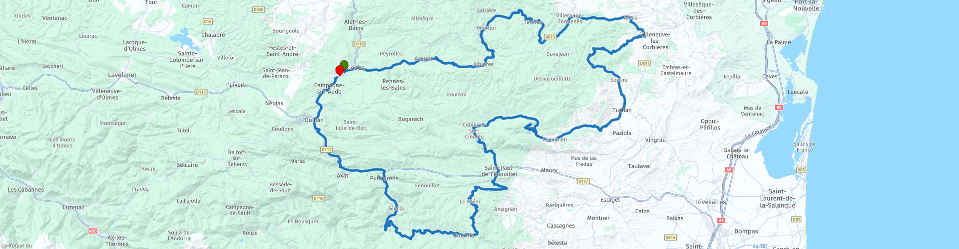
Roundtrip from Esperaza to the Galamus Gorge

This route was brought to you by:
RouteXpert Catherine De Groote RouteXpert
Last edit: 18-11-2023
 Route Summary
 It has a rich history and is named after the Cathars, a religious group active in the south of France in the 12th and 13th centuries.
The Pays des Cathares is dotted with impressive castles and fortifications dating back to the Middle Ages. Many of these castles were used as strongholds by the Cathars during the Crusades. In addition to the historical aspects, the area also has a beautiful landscape with mountains, valleys and vineyards. It also has its own unique culture and traditions. Local festivals, markets and culinary specialties add to the charm of the region.
Today the area is a popular tourist destination, both for its historical significance and its natural beauty.
The Pays des Cathares that you cross from Espéraza is a fascinating region that attracts both history and nature lovers. It embodies the legacy of the Cathars and offers a unique look at the medieval history of southern France.
Some highlights on this ride are the castles of Arques, Peyrepertuse and Puilaurens and the beautiful Gorges de Galamus and Défilé de la Pierre Lys… The highest point is the Col d'Aussières (1020 m). The roads are generally very good and there is little traffic. This tour gets 5 stars without a doubt.
 Share this route


Verdict


Duration
11h 7m

Mode of travel
Car or motorcycle

Distance
230.47 km

Countries

 RouteXpert Review
 After a few kilometers a green valley opens up. In this unexpected softness rises the Château d'Arques. It dates from the 11th century and it has a rich history. The castle is notable for its medieval architecture, with towers, ramparts and defenses that testify to its original defensive function. The castle has undergone several renovations over the centuries.
Today, the Château d'Arques also functions as a visitors center. Visitors can explore the castle and learn about its history through exhibitions and informative displays. It offers a glimpse into medieval life and the castle's role at the time.
The traffic-calmed roads wind through a mainly lushly wooded hilly landscape, in which the mountains in the background are never far away.
The Col de Paradis, surrounded by the Rialsesse national forest, is 626 m high. The climb is 6.6 km long with an average gradient of 4.0%.
After 25 km you leave the D613 and take the road to the Château de Termes. The road is narrow and meanders through a wild and densely vegetated hilly landscape.
Just below the castle of Termes, which forms the natural defense, the Gorges du Termenet or Clue du Terminet form a spectacular nature reserve. The limestone folds and formations are easily seen from the road or trails. The gorge is wild and narrow and you drive through two tunnels.
The Col de Termes is 'only' 520 m high, but at the top you still get beautiful views. After Cascastel-des-Corbières the landscape becomes more open with beautiful views of the surrounding hills. The road continues to wind with some hairpin bends.
There is a restaurant in Tuchan. Anyone who wants to eat can gratefully make use of this because there are not many options. Restaurant Le Relais d'Aguilar offers you a menu prepared on site with a number of fresh and local products. On the terrace, in the shade of olive trees, you can enjoy the beautiful panorama.
Padern Castle is easily accessible and dominates the village of the same name. It consists of a high polygonal enclosure and the remains of a keep and dwelling. The castle was part of the Lagrasse Abbey from the 9th to the 14th century. Padern Castle stands above the Verdouble gorges. The free entry is signposted from the bottom of the village, where you must leave your vehicle. From the keep the view over the Verdouble valley and the village is remarkable.
Not much later we see the castle of Peyrepertuse in the distance. What was once a proud stronghold is now a stately ruin where the separation between the mountain and the walls is very difficult to see. Peyrepertuse has, as it were, sprung from the rock face and adorns the steep rock walls like a grim crown.
The road to Peyrepertuse is very steep and has several vicious hairpin bends. If you don't like that, it is best to park somewhere on the way to the top in one of the spacious parking facilities.
Finds have shown that Peyrepertuse was already inhabited in Roman times. The place was mentioned for the first time in history in the 9th century. Then, during the time of the
Cathars, Peyrepertuse was a heretical stronghold. Despite its majestic location, the fortress eventually fell into the hands of the French king and therefore the Catholics. The French expanded the chateau considerably and it is the ruins of that complex that are now visited by many thousands of tourists every year. The view you get there is beautiful.
The Gorges de Galamus is one of the most beautiful natural phenomena in this region. You can reach the place via a well-constructed road, through tunnels and along overhanging rocks. This winds along the rocks, 100 m above the river. You can often hear the river clearly even though you can't see it. In some places the road is so narrow that only one car can pass at a time. Of course it's no problem with the engine. Once you arrive at the parking lot, you can continue on foot via various routes. There are beautiful views along the way.
The River Agly has created caves in the gorge. These have been used by hermits to live in them since the 7th century. The “patron saint” was Saint Antoine, the patriarch of the monks in the desert. Halfway through the gorges, the hermitage of Saint-Antoine-de-Galamus is built against the rock wall. A certain Limoux Nègre stayed there in the 14th century. He wanted to fast for 40 days and still survive. As a result, he was arrested by the Inquisition and burned at the stake.
The site was further expanded in the 15th century and the current chapel was built in 1782 in gratitude for the remarkable healings of many inhabitants of Saint-Paul-de-Fenouillet. Hermits lived here until 1950. At a specially constructed viewpoint, attached to a cliff, you have a beautiful view of the monastery.
It is still a traditional place for pilgrimages on Easter Monday and Whit Monday. Many Occitan residents visit the place on Easter Monday and mainly Catalans on Whit Monday. What is striking when visiting the rock chapel is the remarkable stone with a 'Sator square' chiseled into it. The text, which can be read identically in all directions, reads as follows: “Sator arepo tenet opera rotas”, which means “the sower keeps the wheel of the world turning”.
After Saint-Paul-de-Fenouillet, the narrow road climbs with hairpin bends to the Col d'Aussières. The col, a wild and natural place, peaks at an altitude of 1,020 meters. A pleasant scent of aromatic herbs perfumes the place. The pass offers beautiful views of the steep ridges of the Espinouse Plateau. From now on it will go steadily downwards.
The Château de Puilaurens is located at an altitude of approximately 700 meters. It sits on a rocky spur and offers panoramic views of the surrounding valleys and mountains.
The castle dates from the 11th century and played a role in the medieval history of the region. The castle has thick stone walls, towers and defenses that testify to its original military function. As a Cathar stronghold, Puilaurens played an important role in the defense of the Cathars against the attacks of the Catholic Church. The castle served as a refuge for the Cathars during the conflicts of the time.
Today, the Château de Puilaurens is a popular tourist attraction. Visitors can climb and explore the castle, and enjoy views of the surrounding landscape.
You enter the “Defilé de Pierre-Lys” via a tunnel cut into the mountainside. It is a beautiful stretch of road that follows the course of the Aude river through a narrow gorge. In some places large sections had to be cut out of the rock wall to accommodate the road, but that makes the route extra spectacular.
In Quillan you drive across the Aude. This river has a total length of approximately 224 kilometers.
You continue to follow the Aude until Espéraza, the end point of this ride.


 Links
Links  Usage
Usage Want to download this route?
You can download the route for free without MyRoute-app account. To do so, open the route and click 'save as'. Want to edit this route?
No problem, start by opening the route. Follow the tutorial and create your personal MyRoute-app account. After registration, your trial starts automatically.  Disclaimer
Use of this GPS route is at your own expense and risk. The route has been carefully composed and checked by a MyRoute-app accredited RouteXpert for use on TomTom, Garmin and MyRoute-app Navigation.
Changes may nevertheless have occurred due to changed circumstances, road diversions or seasonal closures. We therefore recommend checking each route before use.
Preferably use the route track in your navigation system. More information about the use of MyRoute-app can be found on the website under 'Community' or 'Academy'.

Occitanie
About this region
Occitanie (French pronunciation: [ɔksitani] (listen); Occitan: Occitània [utsiˈtanjɔ]; Catalan: Occitània [uksiˈtaniə]), Occitany or Occitania (), is the southernmost administrative region of metropolitan France excluding Corsica, created on 1 January 2016 from the former regions of Languedoc-Roussillon and Midi-Pyrénées. The Council of State approved Occitanie as the new name of the region on 28 September 2016, coming into effect on 30 September 2016.The modern administrative region is named after the larger cultural and historical region of Occitania, which corresponds with the southern third of France. The region Occitanie as it is today covers a territory similar to that ruled by the Counts of Toulouse in the 12th and 13th centuries. The banner of arms of the Counts of Toulouse, known colloquially as the Occitan cross, is used by the modern region and is also a popular cultural symbol. In 2015, Occitanie had a population of 5,839,867.
Read more on Wikipedia
View region
 Statistics
  72
72Amount of RX reviews (Occitanie)
 25956
25956Amount of visitors (Occitanie)
 3641
3641Amount of downloads (Occitanie)
 Route Collections in this region
 25 Magnificent trails in France
This MRA route collection contains 25 beautiful motorcycle routes in different parts of France, such as the Ardennes, the Alsace, Vercors, the Drôme, the Ardèche, Cote d'Azure, Gorges du Verdon, the Ariège, the Dordogne and Brittany.
The routes have been carefully created by Bert Loorbach, who is an enthusiastic motorcyclist himself. He lived in France for a year and a half, during which time he devoted himself to mapping the unknown and beautiful back roads of France especially for motorcyclists.
The routes are bundled in the Motortourgids France part 1 of Kosmos publishing house and now also available in MyRouteApp.
I have taken over the routes in MRA and sometimes adjusted them slightly to make them even more interesting for the motorcyclist.
View Route Collection
24 Magnificent trails in France
It is clear that France is one of the most beautiful and best touring countries. It offers an incredibly varied landscape with good roads and a pleasant climate. It is not for nothing that you see so many motorcyclists there. My previous collection of 25 routes in France (25 Magnificent routes in France) were based on the route descriptions from the Motortourgids France part 1 made by Bert Loorbach.
This collection of 24 routes comes from Motortourgids France part 2. In this collection, a difference has been made between approach routes and motorcycle tours in a certain area. The approach routes can also be used in combination with the routes from Motortourgids France part 1
The routes are sometimes slightly adjusted based on the tips that Bert Loorbach gives in his description, or because of another place to spend the night, or to reach the minimum length of 2 hours for the MRA Library. For each route, the review contains a more detailed description, including options to stay overnight or places of interest along the way, which are also indicated with a POI and if possible with a short description.
Two or more routes have been created for a number of areas, such as for Burgundy, Auvergne, The Alps, Tarn and Cévennes and Nord-Pas de Calais. These routes can be nicely combined in a multi-day trip.
View Route Collection