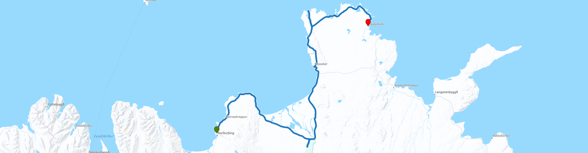
Arctic Coast Way Day 5 Husavik Raufarhofn

This route was brought to you by:
RouteXpert René Plücken (MRA Master)
Last edit: 16-03-2021
 Route Summary
 The Arctic Coast Way starts in Hvammstangi in the North West and ends in Bakkafjörður in the North East. This approximately 900 kilometer long “Off the Beaten track” route passes through rugged North Iceland and follows the beautiful Fjord coast.
Driving the Arctic Coast Way is different from what you might be used to. It is a true off the beaten track route that takes you through beautiful remote landscapes. This means leaving civilization behind in the spirit of adventure and exploration.
We drive large parts on unpaved roads (about 1/3 part), sometimes with large holes, so this route is only suitable for Adventure or Off Road motorcycles or for cars with 4x4 drive. Drive slowly to enjoy the magical surroundings but because of the sheep and birds that can walk on the road.
The route runs close to the Arctic Circle and many stops are planned along the way to visit Iceland's many highlights. A number of examples are the many waterfalls, glaciers, fishing villages and fjords. In some cases you have to take a walk (hike), these can influence the planning of the rides, so keep that in mind. Due to the slower speed on the unpaved roads and the sights en route, the routes have been kept short.
Enjoy the freedom along the way, but respect nature and keep in mind that wild camping is prohibited, you are only allowed to camp on campsites or with the permission of the owner on his private property. All villages along the route have camping options. All campsites have rubbish bins and sanitary facilities. Do not drive off-road, but stay on the designated roads. Off-road driving is prohibited, with heavy fines.
This is the fifth day of the six-day Arctic Coast Way Roadtrip which I rate with 5 ***** Stars for the beautiful nature, beautiful places to visit and the adventurous aspect.
Enjoy!
 Share this route


Animation

Verdict


Duration
11h 44m

Mode of travel
Car or motorcycle

Distance
173.12 km

Countries

 RouteXpert Review
 There are a number of beautiful points along the route for which we have to walk a lot. There is also the possibility to visit a number of museums and we visit Vatnajokull National Park. Make sure you bring plenty of water and food.
We leave Húsavik early and drive North, at RP2 we can visit the museum in Mánárbakki. This museum was opened on June 18, 1995 in the Þórshamri house that was moved from Húsavík to Mánárbakki.
The Manarbakki Farm is the site of a unique private museum and meteorological station. This private museum is small but very nice and houses an interesting collection of household items. The old and funny but fun things in life remind us that time is a wonderful thing. The owners will open the museum to visitors upon request.
The next shorter stop is De Hringsbjarg cliff (RP3), which is a towering 60 meter cliff on the east side of the Tjörnes peninsula in North East Iceland. From the cliff you have a spectacular view of Fjallahöfn and the vast plains of Kelduhverfi province, which divide the Tjörnes peninsula and the Öxarfjörður fjord. During Iceland's puffin season, this is an excellent location to view this delightful bird with its colorful beak and orange legs.
We continue to RP4, where we visit Asbyrgi Gorge and Botnstjörn Pond.
Take a walk through the Ásbyrgi Glacier Gorge and the forest. The horseshoe-shaped gorge is part of the Vatnajökull National Park and is ~ 3.5 km long and over 1 km wide.
Over half its length, the gorge is divided in the middle by a striking 25 meter high rock formation called Eyjan ("the island"), from which a wide landscape can be seen. The steep walls of the gorge are formed by cliffs up to 100 meters high. Inside the gorge is a forest of birch and willow trees.
We briefly leave the Arctic Coast Way to visit The Earthquake Center (RP6) in Kópasker. It mainly commemorates the Kópasker earthquake, which occurred on January 13, 1976 and must have been about 6.3 on the Richter scale. It was the largest earthquake in the seismic cycle that had been continuous since December 20, when the Krafla fires started. In Kópasker we can also take a short break at the grocery shop with café (RP7).
The first hike is planned at Rauðinúpur Cliff (RP11). To do this, turn left at RP10 and drive down to Núpskatla farm. Don't forget to close the gate you have to go through. From the parking lot at the farm you can walk to the cape in about 30-45 minutes.
Keep in mind that you can be attacked by the Arctic tern, you can borrow a stick from the parking lot to protect your head from the attacks, an umbrella works well too.
Rauðinúpur Cliff has a beautiful red color, the color comes from red lapilli. Hike up the slope leading to a lighthouse and two beautiful Sea Stacks called "Karlinn" and "Sölvanöf".
The second hike is planned at the Hraunhafnartangi (RP13). The walk takes 30 minutes. This is the second northernmost point on mainland Iceland and is notable for its beautiful sleek Hraunhafnartangi lighthouse.
After about 10 kilometers we turn right to view a special building; “The Arctic Henge” (RP14) is comparable to its old predecessor “The Stonehenge”. This newly built monument is also a huge sundial, aimed to capture the sun's rays and project the shadows in precise locations. A beautiful building!
We drive to the Coffee Shop Kaupfélagið Raufarhöfn (RP15) where we have a drink.
We fill up our bikes at the gas station for the last ride, which is scheduled for tomorrow, before pitching the tent at Camp Site Raufarhafnar (RP16), today's end point.


 Links
Links  Usage
Usage Want to download this route?
You can download the route for free without MyRoute-app account. To do so, open the route and click 'save as'. Want to edit this route?
No problem, start by opening the route. Follow the tutorial and create your personal MyRoute-app account. After registration, your trial starts automatically.  Disclaimer
Use of this GPS route is at your own expense and risk. The route has been carefully composed and checked by a MyRoute-app accredited RouteXpert for use on TomTom, Garmin and MyRoute-app Navigation.
Changes may nevertheless have occurred due to changed circumstances, road diversions or seasonal closures. We therefore recommend checking each route before use.
Preferably use the route track in your navigation system. More information about the use of MyRoute-app can be found on the website under 'Community' or 'Academy'.

Iceland
About this region
Iceland (Icelandic: Ísland; [ˈistlant] (listen)) is a Nordic island country in the North Atlantic Ocean and the most sparsely populated country in Europe. The capital and largest city is Reykjavík. Reykjavík and the surrounding areas in the southwest of the country are home to over two-thirds of the population. Iceland is the only part of the Mid-Atlantic Ridge that rises above sea-level, and its central volcanic plateau is erupting almost constantly. The interior consists of a plateau characterised by sand and lava fields, mountains, and glaciers, and many glacial rivers flow to the sea through the lowlands. Iceland is warmed by the Gulf Stream and has a temperate climate, despite a high latitude just outside the Arctic Circle. Its high latitude and marine influence keep summers chilly, and most of its islands have a polar climate.
According to the ancient manuscript Landnámabók, the settlement of Iceland began in 874 AD when the Norwegian chieftain Ingólfr Arnarson became the first permanent settler on the island. In the following centuries, Norwegians, and to a lesser extent other Scandinavians, emigrated to Iceland, bringing with them thralls (i.e., slaves or serfs) of Gaelic origin.
The island was governed as an independent commonwealth under the Althing, one of the world's oldest functioning legislative assemblies. Following a period of civil strife, Iceland acceded to Norwegian rule in the 13th century. The establishment of the Kalmar Union in 1397 united the kingdoms of Norway, Denmark, and Sweden. Iceland thus followed Norway's integration into that union, coming under Danish rule after Sweden's secession from the union in 1523. Although the Danish kingdom introduced Lutheranism forcefully in 1550, Iceland remained a distant semi-colonial territory in which Danish institutions and infrastructures were conspicuous by their absence.In the wake of the French Revolution and the Napoleonic Wars, Iceland's struggle for independence took form and culminated in independence in 1918 and the founding of a republic in 1944. Although its parliament (Althing) was suspended from 1799 to 1845, the island republic has been credited with sustaining the world's oldest and longest-running parliament.
Until the 20th century, Iceland relied largely on subsistence fishing and agriculture. Industrialization of the fisheries and Marshall Plan aid following World War II brought prosperity, and Iceland became one of the wealthiest and most developed nations in the world. It became a part of the European Economic Area in 1994; this further diversified the economy into sectors such as finance, biotechnology, and manufacturing.
Iceland has a market economy with relatively low taxes, compared to other OECD countries, as well as the highest trade union membership in the world. It maintains a Nordic social welfare system that provides universal health care and tertiary education for its citizens. Iceland ranks high in economic, democratic, and social stability, as well as equality, ranking third in the world by median wealth per adult. In 2020, it was ranked as the fourth-most developed country in the world by the United Nations' Human Development Index, and it ranks first on the Global Peace Index. Iceland runs almost completely on renewable energy.
Icelandic culture is founded upon the nation's Scandinavian heritage. Most Icelanders are descendants of Norse and Gaelic settlers. Icelandic, a North Germanic language, is descended from Old West Norse and is closely related to Faroese. The country's cultural heritage includes traditional Icelandic cuisine, Icelandic literature, and medieval sagas. Iceland has the smallest population of any NATO member and is the only one with no standing army, with a lightly armed coast guard.
Read more on Wikipedia
According to the ancient manuscript Landnámabók, the settlement of Iceland began in 874 AD when the Norwegian chieftain Ingólfr Arnarson became the first permanent settler on the island. In the following centuries, Norwegians, and to a lesser extent other Scandinavians, emigrated to Iceland, bringing with them thralls (i.e., slaves or serfs) of Gaelic origin.
The island was governed as an independent commonwealth under the Althing, one of the world's oldest functioning legislative assemblies. Following a period of civil strife, Iceland acceded to Norwegian rule in the 13th century. The establishment of the Kalmar Union in 1397 united the kingdoms of Norway, Denmark, and Sweden. Iceland thus followed Norway's integration into that union, coming under Danish rule after Sweden's secession from the union in 1523. Although the Danish kingdom introduced Lutheranism forcefully in 1550, Iceland remained a distant semi-colonial territory in which Danish institutions and infrastructures were conspicuous by their absence.In the wake of the French Revolution and the Napoleonic Wars, Iceland's struggle for independence took form and culminated in independence in 1918 and the founding of a republic in 1944. Although its parliament (Althing) was suspended from 1799 to 1845, the island republic has been credited with sustaining the world's oldest and longest-running parliament.
Until the 20th century, Iceland relied largely on subsistence fishing and agriculture. Industrialization of the fisheries and Marshall Plan aid following World War II brought prosperity, and Iceland became one of the wealthiest and most developed nations in the world. It became a part of the European Economic Area in 1994; this further diversified the economy into sectors such as finance, biotechnology, and manufacturing.
Iceland has a market economy with relatively low taxes, compared to other OECD countries, as well as the highest trade union membership in the world. It maintains a Nordic social welfare system that provides universal health care and tertiary education for its citizens. Iceland ranks high in economic, democratic, and social stability, as well as equality, ranking third in the world by median wealth per adult. In 2020, it was ranked as the fourth-most developed country in the world by the United Nations' Human Development Index, and it ranks first on the Global Peace Index. Iceland runs almost completely on renewable energy.
Icelandic culture is founded upon the nation's Scandinavian heritage. Most Icelanders are descendants of Norse and Gaelic settlers. Icelandic, a North Germanic language, is descended from Old West Norse and is closely related to Faroese. The country's cultural heritage includes traditional Icelandic cuisine, Icelandic literature, and medieval sagas. Iceland has the smallest population of any NATO member and is the only one with no standing army, with a lightly armed coast guard.
View region
 Statistics
  18
18Amount of RX reviews (Iceland)
 13890
13890Amount of visitors (Iceland)
 576
576Amount of downloads (Iceland)
 Route Collections in this region
 On an adventure in Iceland
12 Day Iceland Road Trip
Driving in Iceland is a great experience whether you travel by car or as described in this review by motorcycle.
This route collection is based on information about Iceland that you can find on the Internet, especially from the Guide to Iceland, where you can find a wealth of information to prepare you well for your trip.
You drive through landscapes that are varied and beautiful, you see glacier tongues, volcanic mountains, geothermal areas with active geysers, lava fields, craters, forests, waterfalls and incredibly rugged stretches of coast. You will also see many animals such as seals, killer whales, humpback whales, puffins, gulls, olives and petrels
The main roads are of good quality but you also drive a lot on gravel roads, so not suitable for road motorcycles. Some of these roads are sometimes closed due to the weather.
It is therefore important that you check the weather forecasts and the situation of the roads every day before you leave, this information can be found on the website of "Icelandic Meteorological Office" and for the roads on the website of "The Icelandic Road and Coastal Administration" "
Due to the Icelandic climate this trip can only be made in the summer and is suitable for car and motorcycle. Renting cars (also 4x4) and motorbikes is possible in Reykjavik.
If you want your own car or motorcycle, you can make a ferry crossing from the Netherlands or Denmark via the Faroe Islands. Then take another week off for the crossings, or longer because you can also make beautiful rides on Faroe Islands.
This route collection consists of the following routes
Day 1 from Reykjavik to Vik (350km)
Day 2 from Vik to Kirkjubaejarklaustur (215km)
Day 3 from Kirkjubaejarklaustur to Hoefn (225km)
Day 4 from Hoefn to Seydisfjoerdur (295km)
Day 5 from Seydisfjoerdur to Husavik (300km)
Day 6 from Husavik to Siglufjordur (260km)
Day 7 from Siglufjordur to Blonduos (220km)
Day 8 from Blonduos to Reykholar (325km)
Day 9 from Reykholar to Patreksfjordur (455km)
Day 10 from Patreksfjordur to Grundarfjordur (280km)
Day 11 from Grundarfjordur to Borgarnes (210km)
Day 12 from Borgarnes to Reykjavik (270km)
View Route Collection
Adventure Tour along the Arctic Coast Way in Iceland
Iceland is a pearl on the earth with many natural beauties. In 2019, the Arctic Coast Way was opened to allow travelers to enjoy untouched nature. The Arctic Coast Way is a great opportunity to see wildlife, dive geothermal pools and take part in adventure activities such as hiking, boating and horseback riding, surrounded by sea and mountain views.
The Arctic Coast Way starts in Hvammstangi in the north-west and ends in Bakkafjörður in the north-east. This approximately 900 kilometer long “Off the Beaten track” route passes through rugged North Iceland and follows the beautiful Fjord coast.
Driving the Arctic Coast Way is different from what you might be used to. It is a true off the beaten track route that takes you through beautiful remote landscapes. This means leaving civilization behind in the spirit of adventure and exploration.
We drive large parts on unpaved roads (about 1/3 part), sometimes with large holes, so this route is only suitable for Adventure or Off Road motorcycles or cars with 4x4 drive. Drive slowly to enjoy the magical surroundings but because of the sheep and birds that can walk on the road.
The route runs close to the Arctic Circle and many stops are planned along the way to visit Iceland's many highlights. A number of examples are the many waterfalls, glaciers, fishing villages and fjords. In some cases you have to take a walk (hike), these can influence the planning of the rides, so keep that in mind. Due to the slower speed on the unpaved roads and the sights along the way, the routes have been kept short.
Enjoy the freedom along the way, but respect nature and keep in mind that wild camping is prohibited, you are only allowed to camp on campsites or with the permission of the owner on his private property. All villages along the route have camping options. All campsites have rubbish bins and sanitary facilities. Do not drive off-road, but stay on the designated roads. Off-road driving is prohibited, with heavy fines.
The routes are;
Day 1 from Hvammstangi to Blönduós
Day 2 from Blönduós to Grettislaug
Day 3 from Grettislaug to Siglufjörður
Day 4 from Siglufjörður to Húsavik
Day 5 from Húsavik to Raufarhöfn
Day 6 from Raufarhöfn to Bakkafjörður
View Route Collection