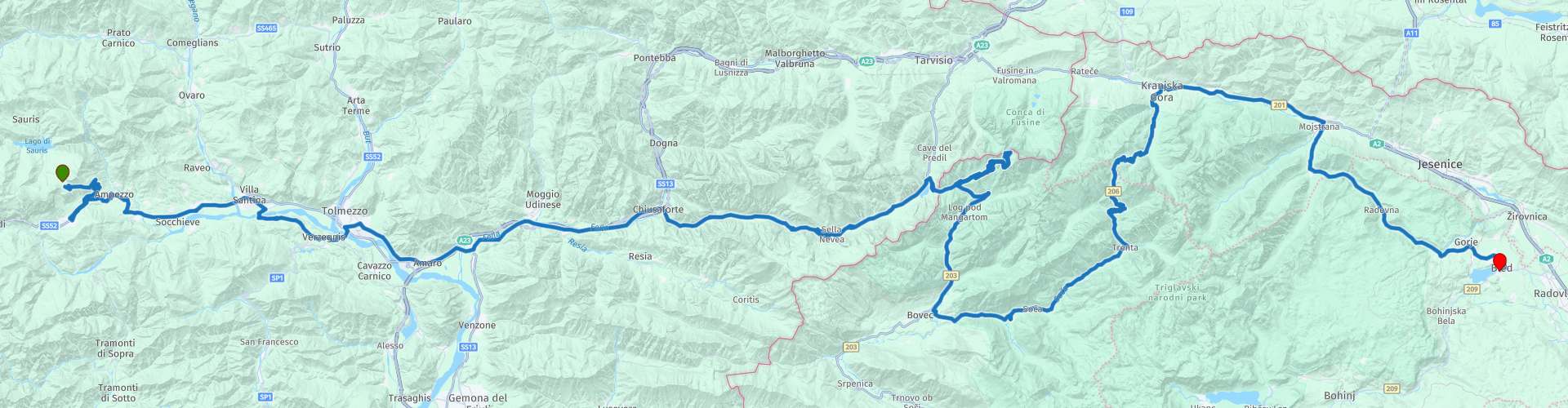
05 From Lago di Sauris to Bled via Triglav National Park

This route was brought to you by:
RouteXpert Leonor Orban - Sr. RouteXpert
Last edit: 29-07-2021
 Route Summary
 This route has two faces. One is clearly visible, let you fully enjoy and continuously look around you with admiration. The other face is heavy and loaded, less visible but always present. The nature reserves that you visit today are truly beautiful. You fall from one beautiful place to the next, even more beautiful place.
But as Wikipedia describes it so well: "No matter how emerald the river is, the area along it is also colored red in a metaphorical sense". The area around the Soča valley and the Triglav mountains is filled with a loaded history. During World War I, heavy battles were fought between the Italian army and soldiers of the Austro-Hungarian Empire along the route you drive today. Traces of this can be found here and there.
Today both faces are discussed. The route runs from Lago di Sauris to the East along the Tagliamento river to cross the border at Lago di Predil to Slovenia. In this border area you can see the first traces of the war. After a “trip” to the Mangart pass, you continue your route along the emerald Soča river and over the Vrsic pass. Here you will also find several monuments, which recall a difficult period in the history of Europe and at the same time show that this river is one of the most beautiful in Europe.
Eventually you drive via a beautiful and easily accessible road to Lake Bled, where you can take a lovely walk at the end of the day. Or of course just enjoy a local Slovenian beer on a terrace overlooking the lake.
 Share this route


Animation

Verdict


Duration
4h 47m

Mode of travel
Car or motorcycle

Distance
215.23 km

Countries


 RouteXpert Review
 Today we drive through a beautiful piece of Italy to Slovenia. In Slovenia we visit the area of the Soča river and valley, the Triglav National Park and finish at Lake Bled.
This route has two faces. One is clearly visible, let you fully enjoy and continuously look around you with admiration. The other face is heavy and loaded, less visible but always present. The nature reserves that you visit today are truly beautiful. You fall from one beautiful place to the next, even more beautiful place.
But as Wikipedia describes it so well: "No matter how emerald the river is, the area along it is also colored red in a metaphorical sense". The area around the Soča valley and the Triglav mountains is filled with a loaded history. During World War I, heavy battles were fought between the Italian army and soldiers of the Austro-Hungarian Empire along the route you drive today. Traces of this can be found here and there.
Today both faces are discussed. The route runs from Lago di Sauris to the East along the Tagliamento river to cross the border at Lago di Predil to Slovenia. In this border area you can see the first traces of the war. After a “trip” to the Mangart pass, you continue your route along the emerald Soča river and over the Vrsic pass. Here you will also find several monuments, which recall a difficult period in the history of Europe and at the same time show that this river is one of the most beautiful in Europe.
Eventually you drive via a beautiful and easily accessible road to Lake Bled, where you can take a lovely walk at the end of the day. Or of course just enjoy a local Slovenian beer on a terrace overlooking the lake.
The day starts peacefully, on the mountain at Rifugio Tita Piaz. If you have spent the night here, you can enjoy the rising sun in peace and the last part of the Passo del Pura. You drive down the mountain and keep your eye on it: turn left at the main road (T-junction) to continue your route. Garmin gives an incorrect instruction (RP 2) here.
After refueling in Ampezzo, follow the route eastwards along the Tagliamento. This river originates near the Passo della Mauria (at 1195m) and flows from the Alps into the Adriatic sea. The special thing about this river is that it is the last river, the current of which is not adapted by man. This gives the river an enormous diversity of flora and fauna. Scientists like to do research on and along the river. As part of this route, the river is especially scenic and offers plenty of moments for nice holiday photos with the river in the background or foreground. Eventually the Tagliamento swings to the South near the city of Amaro to disappear into the Adriatic Sea at the Gulf of Venice.
The route continues eastwards, confidently towards the border with Slovenia. Along the way you will encounter the first traces of the “Great War”: Forte di Col Badin (RP 10). The fortress was built just before World War I in an attempt to defend Italy against Austria-Hungary. There was never a serious battle here too far from the front. The fort was only activated after the defeat and withdrawal of the Italian troops at the 12th battle of Isonzo. These 12 strokes around the Isonzo shape the “red color” of the area you will be driving through later today. Isonzo is the Italian name for the aforementioned Soča river and valley. Forte di Col Badin now houses a museum of mountain warfare during WWI For now, leave the fortress on the left and drive underneath it, as you will come across several places later today that commemorate WWI and are easier to reach and can be visited with your motorcycle gear on.
On the SP76, after about 1.5 hours of driving, you can take a break at the foot of the Sella Nevea (RP 12) at Trattoria al Fontanon (RP 11). This restaurant is about 10 minutes walk from Fontanone di Goriuda. The special thing about this waterfall is that you can walk behind it. Once you are behind the waterfall, you have a magnificent view from the cave of the waterfall falling down and the mountains (don't forget to take a picture here!). Of course, before you start your hike, you can ask the innkeeper to leave your motorbike gear in the trattoria until you return for a well-deserved large glass of drink and a tasty bite to eat.
After this break, you can loosen your hips on the hairpin bends of the Sella Nevea and continue towards Lago del Predil. This area is the first clear example of the two faces of this region. At RP 14 you have a good stop for beautiful photos of the Predil Lake. It is certainly nice to walk to the small island in the lake at low tide. At the same time you clearly see the other face this time. On both the west and east sides of the lake you will find three fortresses (RP 12, RP 14 and RP 15) that played an important role in the success of the Austro-Hungarian army. The first fort (RP 12) was located directly on the shores of the lake and served as a guard for the route to the West (where you just came from). The second fort, or Batteria del Predil (RP 14), is a little further away from the lake and came from WWI almost undamaged. This fortress was used as a weapon storage for a short period by the Austro-Hungarian army. In 1915, all artillery was moved to a storage facility in the mountain. Because the Batteria came out intact WWI, it is now also open for visitors. The third fort (Predel; RP 15) also served as a weapon store, but largely collapsed due to neglect after WWI. Further along the route you will also pass Fort Kluže (RP 18).
If you are interested in visiting a fortress and learning more about the mountain wars in this area, it is interesting to stop at Fort Kluže (RP 18) or Batteria del Predil (RP 14) and have a look around. Especially considering the length of the route, it is difficult to visit all fortresses.
But before you pass Fort Kluže, you first make an impressive climb to the highest point of the Mangart pass. This dead end mountain pass is the highest asphalted mountain pass in the Julian Alps and Slovenia. There is a toll booth at the foot of the pass. Sometimes it is manned, sometimes it is not. In the latter case, you can continue driving, in the former you pay a small amount that absolutely pays for itself.
The road winds along steep mountain sides and a number of tunnels to an altitude of 2060 meters. At the top of the mountain you can drive a lap and follow the same road down again. Before you go down, you can stop at Viewpoint Mangartsko Sedlo (photo stop RP 17). Here you have an exciting photo opportunity. From the parking lot it is a short walk to the Lahnscharte. From this part of the mountain you have a spectacular view of the Italian mountains and valleys, including Lago di Fusine Inferiore (lake). The spectacular thing about this view is the 600m steep drop in the mountain wall under your feet. So it is good to be careful where you walk!
After the Mangart pass you enter the area of the valley of the Soča river. Here you will find the aforementioned Fort Kluže, but also a military cemetery (RP 19) to commemorate the more than 200,000 Austro-Hungarian soldiers who fell on the Isonzo front.
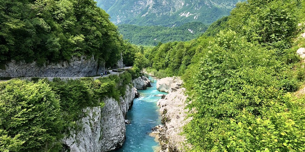
Fortunately, the area also has a lot to offer. Due to the emerald green color and the wild current of the water, many tourists come to this area for hiking, touring and rafting. For example, the Soča Grand Canyon (rp 20) and Soča Gorge (rp 21) are two special points in the river. Here you can see how the river has cut its way through the landscape. At the gorge there are also opportunities to take a break at a local restaurant. You can swim in large parts of the river to cool off. Especially at the Grand Canyon this can be worthwhile, because of the beautiful green natural baths in the river.
The route continues along the Soča River to the North over the Vršič pass. If you have time and interest, you can deviate from the route at rp 22 to visit the origin of the Vršič river. At low tide you can get to the source of the Soča.
With a total of 50 hairpin bends, the Vršič pass is a phenomenal pass in the Eastern Julian Alps. Driving here is a great pleasure. The views are majestic and the curves delightful. Enjoy the good road quality, especially on the South side. The descent on the South side offers a nice challenge as well as insight into the First World War. The pass was built by Russian prisoners of war during WWI as a military road through the Isonzo Valley. More than 400 soldiers died in a severe avalanche in 1916. A beautiful wooden chapel has been built along the route in memory of these soldiers (rp 27). From the parking lot it is a short walk to the chapel.
The pass eventually leads you to Kransjka Gora, the largest ski area in Slovenia. From here it is a respite from the hard work on the pass. A well-deserved break can therefore be taken at Restaurant Rožca (rp 27). You can also discuss here with your motorcycle friends how you want to drive the last part to Bled. This route turns south at rp 28 and continues through the Radovna valley to Bled. This road is (under normal circumstances) very good to drive despite the unpaved nature. It is a well rammed wide gravel road and pleasant to drive. The road is quiet and winds through the woods, past some hills and meadows towards Bled. The main road (201 and 452) to Bled, on the other hand, is busy, straightforward and uninspiring. If it is already late and you want to arrive at the hotel quickly, this is the best alternative. If you still have time, energy and an unpaved gravel road does not deter you, just choose to continue the route.
After a few last unpaved kilometers, the bustle of the city of Bled comes to you. On the way you can refuel and then park your motorbikes at the hotel. Don't forget to stretch your legs and take a walk to Lake Bled.
This route gets 5 stars. Unfortunately, this is the maximum number of stars that can be assigned to a route. It secretly deserves more. The part of the route in Italy is already very beautiful, but as soon as the lake of Predil (Lago del Predil) comes into view, you realize that today is really going to be a very nice day. The nature reserves are impressively beautiful, intact and overwhelming. This area is also so rich in history that it actually deserves more attention than just visits as part of a motorcycle ride.

 Links
Links  Usage
Usage Want to download this route?
You can download the route for free without MyRoute-app account. To do so, open the route and click 'save as'. Want to edit this route?
No problem, start by opening the route. Follow the tutorial and create your personal MyRoute-app account. After registration, your trial starts automatically.  Disclaimer
Use of this GPS route is at your own expense and risk. The route has been carefully composed and checked by a MyRoute-app accredited RouteXpert for use on TomTom, Garmin and MyRoute-app Navigation.
Changes may nevertheless have occurred due to changed circumstances, road diversions or seasonal closures. We therefore recommend checking each route before use.
Preferably use the route track in your navigation system. More information about the use of MyRoute-app can be found on the website under 'Community' or 'Academy'.

Friuli Venezia Giulia
About this region
Friuli Venezia Giulia (pronounced [friˈuːli veˈnɛttsja ˈdʒuːlja]) is one of the 20 regions of Italy, and one of five autonomous regions with special statute. The regional capital is Trieste.
The name used to be hyphenated as Friuli-Venezia Giulia until 2001. The region is called Friûl Vignesie Julie in Friulian, Furlanija Julijska krajina in Slovene and Friaul Julisch Venetien in German, three languages spoken in the region. The city of Venice ("Venezia") is not in this region, despite the name.
Friuli Venezia Giulia has an area of 7,924 km2 and about 1.2 million inhabitants. A natural opening to the sea for many Central European countries, the region is traversed by the major transport routes between the east and west of southern Europe. It encompasses the historical-geographical region of Friuli and a small portion of the historical region of Venezia Giulia – also known in English as the Julian March – each with its own distinct history, traditions and identity.
Read more on Wikipedia
The name used to be hyphenated as Friuli-Venezia Giulia until 2001. The region is called Friûl Vignesie Julie in Friulian, Furlanija Julijska krajina in Slovene and Friaul Julisch Venetien in German, three languages spoken in the region. The city of Venice ("Venezia") is not in this region, despite the name.
Friuli Venezia Giulia has an area of 7,924 km2 and about 1.2 million inhabitants. A natural opening to the sea for many Central European countries, the region is traversed by the major transport routes between the east and west of southern Europe. It encompasses the historical-geographical region of Friuli and a small portion of the historical region of Venezia Giulia – also known in English as the Julian March – each with its own distinct history, traditions and identity.
View region
 Statistics
  18
18Amount of RX reviews (Friuli Venezia Giulia)
 34417
34417Amount of visitors (Friuli Venezia Giulia)
 2483
2483Amount of downloads (Friuli Venezia Giulia)
 Route Collections in this region
 The 24 Most Beautiful Alpine Routes
The Alps, The Alps are a mountain range in Europe, stretching from the French Mediterranean coast in the southwest to the Pannonian Plain in the east. The area of the mountain range is more than 200,000 km².
In other words Passes and Mountain Roads!
Driving through the mountains is great! Especially over the mountain passes with hairpin bends and narrow winding roads. Every bend a different view where you can enjoy. There are many beautiful mountain passes in the Alps.
A selection that has also been incorporated into these routes:
The Stlevio Pass:
The Stelvio Pass, also known as Passo dello Stelvio, is mainly known for the stage in the Giro d'Italia. Due to the length and the difference in height, this pass is seen as one of the toughest tests in cycling. The Stelvio Pass reaches a maximum height of 2758 meters and is therefore one of the highest in the Alps. The pass connects the towns of Bormio and Prato Allo Stelvio. In winter the pass is closed due to heavy snowfall.
The Reschenpass:
The Reschenpass, also known as Passo di Resia, connects the Austrian state of Tyrol with the Italian province of South Tyrol. The pass reaches a maximum height of 1,504 meters and has been one of the most important north-south connections in the Alps in recent centuries. The pass was used long before Roman times. Along the way you will pass several highlights and historical relics. One of the highlights is the Reschensee. This lake was created after the construction of the dam and has completely submerged the village of Graun. The only thing that reminds of that is the clock tower in the middle of the lake.
Col du Galibier:
The French mountain pass Col du Galibier connects the towns of Saint-Michel-de-Maurienne and Briançon via the Col du Lautaret in the south and the Col du Télégraphe in the north. The mountain pass is part of the Tour de France and very much feared, due to the fact that it can only be reached via the other two mountain passes. The pass reaches a maximum height of 2646 meters. From there you can take a walk to the viewpoint at 2704 meters. You can admire the peaks of the Grand Galibier, Mont Blanc and La Meije here.
The Grossglockner High Alpine Road:
With a height of 3798 meters the Grossglockner is the highest mountain in Austria. To fully enjoy this impressive mountain, you can drive over the Grossglockner High Alpine Road and the accompanying pass. The route starts from Bruck am Grossglockner and ends in Heiligenblut. Of course you can drive in two directions. The pass reaches a maximum height of 2504 meters and is closed in winter due to heavy snowfall. Along the way you pass several stops with fun activities, information points, mountain huts and viewpoints. A visit to the Kaiser-Franz-Josefs-Höhe and Pasterzen Glacier is highly recommended.
The Col d'Izoard:
Just like the Col du Galibier, the Col d'Izoard is also part of a stage of the Tour de France. The mountain pass connects Briançon with the valley of the river Guil. The pass is partly located in the Regional Natural Park du Queyras and reaches a maximum height of 2360 meters. What is special about the Col d'Izoard is the barren and rocky landscape. Sometimes it feels like driving a car over the moon! Along the way you can stop at several points to enjoy the beautiful view.
The Bernina Pass:
The Bernina Express is one of the most famous rail trains in Switzerland and the Alps. The route is beautiful and partly included on the UNESCO World Heritage List. Parallel to the railway lies the Bernina pass, which connects the Veltlin valley with the Egandin valley. This beautiful Alpine road has a total length of 56 kilometers and reaches a maximum height of 2328 meters. Along the way you can enjoy views of the Morteratsch Glacier.
The Sella Pass:
The Sella Pass, also known as Passo di Sella, takes you over one of the most impressive mountain ranges in the Dolomites: the Sella massif. The pass connects Valle di Fassa with Val Gardena and reaches a maximum height of 2236 meters. At this height is also the border of the Italian provinces of Trentino and Bolzano. Along the way you can enjoy the view of this spectacular mountain world. Admire, for example, the three peaks of the Sasso Lungo massif, the Sella massif or the peaks of the Marmolada. You can also drive the Sella pass in combination with the Gardena pass, Pordoi pass and Campolongo pass.
The Grimsel Pass:
The Grimsel Pass connects Goms in Wallis with the Halis Valley in the Bernese Oberland. The pass reaches a maximum elevation of 2165 meters and is closed in winter due to snowfall. Over the centuries, the mountain pass has played an important role in trade between Switzerland and Italy. Now it is mainly the reservoirs that have an important function. These are used to generate electricity. The landscape you drive through is rugged, rocky and impressive. On top of the pass is a hotel and a restaurant with a special marmot park. The Dodensee (Totensee) is also located here. This lake owes its name to the many soldiers who died in the time of Napoleon.
The Gotthard Pass:
The Gotthard Pass, also known as Passo del San Gottardo and Saint Gotthard, connects the Swiss towns of Airolo and Andermatt. The mountain pass and associated tunnel are especially known among holidaymakers driving from Switzerland to Italy. But where the majority opt for the tunnel, it is precisely the pass that really completes the holiday. The Gotthard Pass has a length of about 26 kilometers and reaches a maximum height of 2106 meters. The route is beautiful and takes you along old villages and beautiful views.
The Silvretta High Alpine Road and Silvretta Pass:
The Paznaun Valley in Tyrol and the Montafon in Vorarlberg are connected by the Silvretta High Alpine Road. The route has a length of 22.3 kilometers and leads from Galtür to Partenen in 34 hairpin bends, via the 2032 meter high Bielerhöhe. The Silvrettasee is also located at this point, where you can enjoy a lovely walk. The pass is closed in winter due to snowfall.
The Simplon Pass:
Just like the Gotthard Pass, many holidaymakers also travel over the Simplon Pass every year. This mountain pass connects the Rhone Valley in the canton of Valais with the Valle d'Ossola in Piemonte. The pass is open all year round and reaches a maximum height of 2005 meters. Along the way you pass a number of buildings, including the well-known Simplon Hospiz from 1825. The hospiz is managed by the monks of St. Bernard. From the highest point on the pass, all kinds of hiking routes are possible and you will also come across a hotel where you can spend the night.
The Gerlos Pass:
The Gerlos Pass connects the Salzach Valley in the Salzburgerland with the Zillertal Valley in Tyrol. The pass is part of the Gerlos Alpenstraße and runs right through the Hohe Tauern National Park. Along the way you can enjoy beautiful views of the surroundings. The pass has a length of 12 kilometers and reaches a maximum height of 1531 meters. A ride over the Gerlos Pass can be ideally combined with a visit to the Krimmler Wasserfälle.
The Great St. Bernard Pass:
The Great St. Bernard Pass, better known as Col du Grand Saint Bernard, connects the Italian province of Valle d'Aosta with the Swiss canton of Valais. The pass is one of the highest in Switzerland and reaches a maximum height of 2469 meters. Like a number of other mountain passes in this list, the Great St. Bernard Pass has also been used as a connecting road for centuries. The pass is named after the St. Bernard dogs that used to help stranded travelers along with the monks. The pass is closed in winter.
The Timmelsjoch High Alpine Road:
The Timmelsjoch High Alpine Road connects the towns of Sölden in the Ötztal and Meran in South Tyrol. Tolls must be paid on the Hochgurgl - Moos route. Via a mountain road with about 60 hairpin bends you drive through a beautiful mountain world. With the Timmelsjoch Experience you can learn more about the history, the road and the environment via various stations. You can also visit the Top Mountain Crosspoint museum.
Col de l'Iseran:
With a maximum pass height of 2770 meters, the Col l'Iséran is one of the highest mountain passes in the Alps. The pass connects Bourg-Saint-Maurice with Bonneval-sur-Arc. Via a road full of hairpin bends you pass, among other things, Val-d'Isère and a side valley of the Maurienne that lies entirely in the National Park de la Vanoise. You can spot animals such as marmots and chamois and there is also a restaurant with a chapel on top of the pass.
The Gavia Pass:
The Gavia Pass (Italian Passo di Gavia) is a mountain pass in the Italian Alps, in the Lombardy region.
It is one of the highest pass roads in Europe. The road leads through the unspoilt Stelvio National Park. The road was built in the First World War to supply Italian soldiers who fought in the Italian-Austrian border area. The pass height is one of the most beautiful in the Alps. Here is the large Lago Bianco with, to the north, the mountain San Matteo (3684 meters). Lago Nero is slightly lower on the south side of the pass. Here the mountain group of the Adamello determines the view. There are many well-marked walks in the area. During the winter the pass is closed due to the heavy snowfall. The pass is often closed until May and June due to the large amount of snow.
Promoter has made a selection of the 24 Most Beautiful Alpine routes that they have set out in recent years.
The routes go through:
France
Austria
Switzerland
Italy
The most beautiful roads, the most beautiful views, the most beautiful viewpoints. The highest mountains, the fastest descents, hairpin bend after hairpin bend, you name it you can't get enough of it.
If you go on holiday in this region, take advantage of it, ALL routes in this collection have been checked and made equal for TomTom, Garmin and MyRoute-app Navigation by a MyRoute-app RouteXpert.
Have fun with this collection and while driving one of these routes. Enjoy all the beauty that the Alps and the Dolomites have to offer. Click on “View route” to read the review of the chosen route.
I would like to hear your findings about the route(s).
View Route Collection
The 12 most beautiful car and motorcycle routes in Carinthia
“Motorradland Kärnten” where you feel so wonderfully welcome as a motorcyclist!
Own website for motorcyclists, own curated routes, hotels, campsites and guest houses with attention for motorcyclists, a wonderful area where motorcyclists are very popular.
Kärnten or Carinthia, at the crossroads of the Germanic, Slavic and Roman worlds. Three cultures within a few kilometres, southern flair, culinary delights, cross-border tours. Breakfast in Italy, lunch in Slovenia, dinner in Austria - all in one day. Experience the diversity in the borderless Alps-Adriatic region, the area for motorcyclists.
Extensive day trips on winding mountain paths, romantic panoramic routes and beautiful lakes, here the 12 TOP routes Kärnten / Carinthia. Enjoy!
View Route Collection