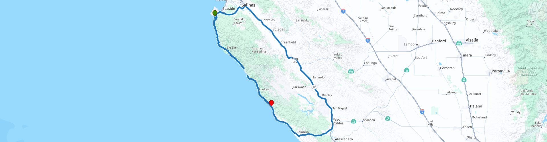
Day 123 The Ultimate USA road trip Carmel Ragged Point

This route was brought to you by:
RouteXpert René Plücken (MRA Master)
Last edit: 31-03-2024
 Route Summary
 I have further supplemented the Road Trip with even more special points that you can visit in the USA. Today we drive from Carmel by the Sea to Ragged Point on the beautiful Big Sur Scenic Byway.
We drive along California's beautiful winding 70 mile (116 km) coastal highway. Along the way you will enjoy beautiful views, beautiful nature, there are several sights to visit and many beautiful viewpoints. I rate this route 5 stars.
 Share this route


Animation

Verdict


Duration
8h 35m

Mode of travel
Car or motorcycle

Distance
124.32 km

Countries

 RouteXpert Review
 The next stop to take a photo is at the end of the beach, at Carmel Point, is the beautiful Mrs. Clinton Walker House, also known as Cabin on the Rocks. The house has the appearance of a ship with a bow cutting through the waves. The house was designed by Frank Lloyd Wright in 1948 and completed in 1952 for Mrs. Clinton "Della" Walker of Pebble Beach. It was listed on the National Register of Historic Places on November 17, 1977.
As we leave Carmel we pass The San Carlos Borromeo de Carmelo Mission, a Roman Catholic mission church and historic monument in Carmel-by-the-Sea, in the Central Coast region of the US state of California. The mission was named after Charles Borromeo, Archbishop of Milan. It was the second Spanish mission of the Franciscans in Alta California. The mission was founded in Monterey on June 3, 1770, and moved to nearby Carmel in December 1771. The Carmel Mission was the favorite mission of missionary Junípero Serra. It was the headquarters of the mission network from 1770. Even after Serra's death in 1784, Carmel remained the headquarters: Serra's successor Padre Fermín Lasuén and his successor Pedro Estévan Tápis also stayed there. Church enthusiasts may consider quitting.
The Big Sur National Scenic Byway begins south of Carmel. Enjoy this amazing ride on this scenic 72-mile route that skirts the California coast and provides access to beautiful parks with cypresses, redwoods, mist-shrouded cliffs, and the surf of the Pacific Ocean. There are many points to enjoy the views of rugged canyons, beautiful arched bridges, towering redwoods, surf, waterfalls, sea lions and other marine life. There are several options for stopping indicated from a Waypoint and POI, but divide your trip according to your own preference. In the links in this review you can find information about the beautiful Scenic Byway
There are several parks that we drive through and where you can stop to walk and enjoy the beautiful nature, such as:
• Point Lobos State Natural Reserve is often called “The Crown Jewel of the California State Park System.” Landscape painter Francis McComas called Point Lobos “the greatest meeting of land and water in the world.” Point Lobos, originally known to the indigenous people as 'Isxhenta', was considered a sacred place to be cherished and nourished. Point Lobos is excellent for sightseeing, photography, painting, nature study, picnicking, SCUBA diving and jogging. The offshore area, part of the Monterey Bay National Marine Sanctuary, forms one of the richest underwater habitats in the world, popular with divers. On land there are rare plant communities, unique geological formations and incredibly rich flora and fauna.
• Garrapata State Park has two miles of beach, with coastal trails and a 50-foot climb to a viewpoint with stunning views of the Monterey Bay National Marine Sanctuary. The park offers diverse coastal vegetation with trails that run from ocean beaches to dense redwood forests. The park also features beautiful coastal headlands at Soberanes Point. Sea lions, harbor seals and sea otters frequent the coastal waters, and California gray whales pass close by during their annual migration.
•Andrew Molera State Park; Still relatively undeveloped, this park offers visitors great hiking and beachcombing, as well as panoramic views of the Monterey Bay National Marine Sanctuary, a federally protected marine area. Miles of trails wind through meadows, cliffs, beaches and hilltops. In the park stands the Cooper Cabin, a 'pioneer cabin', it has long been an object of historical interest and romantic reflection. This three-room structure is built of hand-hewn redwood logs with overlapping and hooked corners and a roof with hand-split redwood shingles.
• Julia Pfeiffer Burns State Park. A major feature of the park is McWay Falls, which falls over an 80-foot cliff into the Pacific Ocean. The park is also home to 300-foot-tall redwoods that are more than 2,500 years old. The park is named after Julia Pfeiffer Burns, a respected resident and rancher in the Big Sur region in the early 20th century who lived in the area for much of her life until her death in 1928. It was established in 1962.
• McWay Falls is a must-stop for anyone taking the scenic drive along Highway One along the Big Sur coast. The waterfall is breathtaking and falls some 25 meters onto a pristine beach in an enchanting bay. It is a short 1-mile round-trip hike to a McWay Falls overlook, which can be reached directly from Highway One or from parking areas at Julia Pfeiffer Burns State Park. McWay Falls Overlook Trail can be reached in two different ways. Option one is to simply park for free along Highway One and follow the trail. You can also drive into Julia Pfeiffer Burns State Park and pay an entrance fee to walk a little further. This is a good option if you plan to spend more time in the park, such as hiking the Canyon Trail, which runs inland along McWay Creek past a picnic area to the smaller Canyon Falls.
The route includes many bridges over canyons, rivers and streams. Special are the seven similar concrete arch bridges known as the “Big Sur Arches”. Known for their thick and heavily curved piers, thin arch rings, and spandrel columns, these beautiful bridges have been hailed as "the most beautiful public works projects in the United States." At some of the bridges it is possible to stop nearby to take beautiful photos;
• Granite Canyon Bridge, a fixed parabolic reinforced concrete arch bridge with open parapet and a single arch span with two 30 meters long ribs.
• Garrapata Creek Bridge, a fixed parabolic reinforced concrete arch bridge with open parapet and a single arch span with two ribs, 45 meters long.
• Rockey Creek Bridge a fixed parabolic reinforced concrete arch bridge with open parapet and a single arch span with two ribs of 151 meters long
• Bixby Creek Bridge is one of the most photographed bridges in California for its aesthetic design, “graceful architecture and beautiful setting.”
There are many places along the route where you can safely stop and park to take photos and walk. Be sure to stop at Hurricane Point, one of the highest points on Highway 1 in the Big Sur region. At an elevation of 550 feet, it is also the toughest climb at the Big Sur International Marathon. You will be treated to spectacular views. Look north, over the Brazil Ranch to Bixby Bridge. Other scenic viewpoints include Big Creek Cove Viewpoint, Gamboa Point, San Martin Rock Scenic Point and Big Sur Lookout
There are several active lighthouses along the coast that you can view, the Point Sur lighthouse is easily accessible. From the parking lot it is a short walk to the Point Sur Lighthouse. It was founded in 1889 and is part of the Point Sur State Historic Park. The lighthouse is 12 meters high and 82 meters above sea level. As of 2016 and for the foreseeable future, the light is still in use as an essential aid to navigation.
The end point of this day is Ragged Point, a small town on the coast on a cliff. Here is the Ragged Point Inn & Resort with beautiful rooms, most of which have beautiful views over the cliff and ocean. There is a good restaurant, shop and gas station.


 Links
Links  Usage
Usage Want to download this route?
You can download the route for free without MyRoute-app account. To do so, open the route and click 'save as'. Want to edit this route?
No problem, start by opening the route. Follow the tutorial and create your personal MyRoute-app account. After registration, your trial starts automatically.  Disclaimer
Use of this GPS route is at your own expense and risk. The route has been carefully composed and checked by a MyRoute-app accredited RouteXpert for use on TomTom, Garmin and MyRoute-app Navigation.
Changes may nevertheless have occurred due to changed circumstances, road diversions or seasonal closures. We therefore recommend checking each route before use.
Preferably use the route track in your navigation system. More information about the use of MyRoute-app can be found on the website under 'Community' or 'Academy'.

California
About this region
California is a state in the Western United States. It shares a border with Oregon to the north, Nevada and Arizona to the east, and the Mexican state of Baja California to the south. With over 39.5 million residents across a total area of approximately 163,696 square miles (423,970 km2), it is the most populous and the third-largest U.S. state by area. It is also the most populated subnational entity in North America and the 34th most populous in the world. The Greater Los Angeles area and the San Francisco Bay Area are the nation's second and fifth most populous urban regions respectively, with the former having more than 18.7 million residents and the latter having over 9.6 million. Sacramento is the state's capital, while Los Angeles is the most populous city in the state and the second most populous city in the country (after New York City). Los Angeles County is the country's most populous, while San Bernardino County is the largest county by area in the country. San Francisco, which is both a city and a county, is the second most densely populated major city in the country (after New York City) and the fifth most densely populated county in the country, behind four of New York City's five boroughs.
The economy of California, with a gross state product of $3.2 trillion as of 2019, is the largest sub-national economy in the world. If it were a country, it would be the 37th most populous country and the fifth largest economy as of 2020. The Greater Los Angeles area and the San Francisco Bay Area are the nation's second- and third-largest urban economies ($1.0 trillion and $0.5 trillion respectively as of 2020), after the New York metropolitan area ($1.8 trillion). The San Francisco Bay Area Combined Statistical Area had the nation's highest gross domestic product per capita ($106,757) among large primary statistical areas in 2018, and is home to five of the world's ten largest companies by market capitalization and four of the world's ten richest people.Prior to European colonization, California was one of the most culturally and linguistically diverse areas in pre-Columbian North America and contained the highest Native American population density north of what is now Mexico. European exploration in the 16th and 17th centuries led to the colonization of California by the Spanish Empire. In 1804, it was included in Alta California province within the Viceroyalty of New Spain. The area became a part of Mexico in 1821, following its successful war for independence, but was ceded to the United States in 1848 after the Mexican–American War. The western portion of Alta California was then organized and admitted as the 31st state on September 9, 1850, following the Compromise of 1850. The California Gold Rush started in 1848 and led to dramatic social and demographic changes, including large-scale immigration into California, a worldwide economic boom, and the California genocide of indigenous people.
Notable contributions to popular culture, for example in entertainment and sports, have their origins in California. The state also has made noteworthy contributions in the fields of communication, information, innovation, environmentalism, economics, and politics. It is the home of Hollywood, the oldest and largest film industry in the world, which has had a profound effect on global entertainment. It is considered the origin of the hippie counterculture, beach and car culture, and the personal computer, among other innovations. The San Francisco Bay Area and the Greater Los Angeles Area are widely seen as centers of the global technology and entertainment industries, respectively. California's economy is very diverse: 58% of it is based on finance, government, real estate services, technology, and professional, scientific, and technical business services. Although it accounts for only 1.5% of the state's economy, California's agriculture industry has the highest output of any U.S. state. California's ports and harbors handle about a third of all U.S. imports, most originating in Pacific Rim international trade.
The state's extremely diverse geography ranges from the Pacific Coast and metropolitan areas in the west to the Sierra Nevada mountains in the east, and from the redwood and Douglas fir forests in the northwest to the Mojave Desert in the southeast. The Central Valley, a major agricultural area, dominates the state's center. Although California is well known for its warm Mediterranean climate and monsoon seasonal weather, the large size of the state results in climates that vary from moist temperate rainforest in the north to arid desert in the interior, as well as snowy alpine in the mountains. All these factors lead to an enormous demand for water. Over time, droughts and wildfires have increased in frequency and become less seasonal and more year-round, further straining California's water security.
Read more on Wikipedia
The economy of California, with a gross state product of $3.2 trillion as of 2019, is the largest sub-national economy in the world. If it were a country, it would be the 37th most populous country and the fifth largest economy as of 2020. The Greater Los Angeles area and the San Francisco Bay Area are the nation's second- and third-largest urban economies ($1.0 trillion and $0.5 trillion respectively as of 2020), after the New York metropolitan area ($1.8 trillion). The San Francisco Bay Area Combined Statistical Area had the nation's highest gross domestic product per capita ($106,757) among large primary statistical areas in 2018, and is home to five of the world's ten largest companies by market capitalization and four of the world's ten richest people.Prior to European colonization, California was one of the most culturally and linguistically diverse areas in pre-Columbian North America and contained the highest Native American population density north of what is now Mexico. European exploration in the 16th and 17th centuries led to the colonization of California by the Spanish Empire. In 1804, it was included in Alta California province within the Viceroyalty of New Spain. The area became a part of Mexico in 1821, following its successful war for independence, but was ceded to the United States in 1848 after the Mexican–American War. The western portion of Alta California was then organized and admitted as the 31st state on September 9, 1850, following the Compromise of 1850. The California Gold Rush started in 1848 and led to dramatic social and demographic changes, including large-scale immigration into California, a worldwide economic boom, and the California genocide of indigenous people.
Notable contributions to popular culture, for example in entertainment and sports, have their origins in California. The state also has made noteworthy contributions in the fields of communication, information, innovation, environmentalism, economics, and politics. It is the home of Hollywood, the oldest and largest film industry in the world, which has had a profound effect on global entertainment. It is considered the origin of the hippie counterculture, beach and car culture, and the personal computer, among other innovations. The San Francisco Bay Area and the Greater Los Angeles Area are widely seen as centers of the global technology and entertainment industries, respectively. California's economy is very diverse: 58% of it is based on finance, government, real estate services, technology, and professional, scientific, and technical business services. Although it accounts for only 1.5% of the state's economy, California's agriculture industry has the highest output of any U.S. state. California's ports and harbors handle about a third of all U.S. imports, most originating in Pacific Rim international trade.
The state's extremely diverse geography ranges from the Pacific Coast and metropolitan areas in the west to the Sierra Nevada mountains in the east, and from the redwood and Douglas fir forests in the northwest to the Mojave Desert in the southeast. The Central Valley, a major agricultural area, dominates the state's center. Although California is well known for its warm Mediterranean climate and monsoon seasonal weather, the large size of the state results in climates that vary from moist temperate rainforest in the north to arid desert in the interior, as well as snowy alpine in the mountains. All these factors lead to an enormous demand for water. Over time, droughts and wildfires have increased in frequency and become less seasonal and more year-round, further straining California's water security.
View region
 Statistics
  43
43Amount of RX reviews (California)
 29737
29737Amount of visitors (California)
 768
768Amount of downloads (California)
 Route Collections in this region
 Car or motorcycle tour through the western US
This collection contains all 15 routes driven by MRA Goldmember André ter Schegget during his three-week tour through the west of America.
The places to visit, the attractions and beautiful photo spots are nicely marked on the routes. The routes have been fully checked and made equal for the Garmin and the TomTom. Enjoy this wonderful trip and let us know how it was! Enjoy and stay safe!
Order of the tour:
Route 01: from Los Angeles and via Pacific Coast Highway to Solvang
Route 02: Solvang to Monterey / Pacific Grove
Route 03A: Monterey to San Francisco
Route 03B: if you are by car instead of the motorcycle, as motorcycles are not allowed on the 17 Mile Drive: from Monterey to the 17 Mile Drive and further to San Francisco
Route 04: from San Francisco via Nappa and Eldorado National Forrest to Topaz Lake
Route 05: from Topaz Lake via Bodie and Yosemite to Oakhurst
Route 06: from Oakhurst via Kings Canyon NP and Sequoia NP and Giant Forest to Exeter
Route 07: Exeter via Isabella Lake and Ridgecrest to Death Valley
Route 08: from Death Valley via Valley Of Fire to Mesquite
Route 09: from Mesquite via Zion NP and Dixie NF to Hatch
Route 10: Hatch via Bryce Canyon to Page
Route 11: from Page via Grand Canyon to Williams
Route 12: from Williams via Seligman and Route 66 to Kingman and via Hoover Dam to Las Vegas
Route 13: from Las Vegas via Oatman and Lake Havasu to Parker
Route 14: from Parker via Joshua Tree to Rancho Mirage
Route 15: Rancho Mirage via Palm Springs to Santa Monica
View Route Collection
The 10 most downloaded routes in the USA from RouteXpert Hans van de Ven
Hello and welcome to this collection of the Top 10 MyRoute app downloaded routes in USA.
There will be a great new event to be announced soon, where all these routes can be driven.
Download them all now and place them in a new "Top 10" folder, so that you always have them at hand.
If you are going to drive one of these routes in the meantime, track them with the MRA Mobile App or with MRA Navigation. Take some photos (moments) along the way as these will come in handy.
Create a travelogue of your Top 10 driven routes and add the recorded track to it.
There will also be some great prizes on offer, so keep an eye on the MRA-RouteXperts page and your mail.
The 10 routes are:
1. D13 Estes Park Denver
2. D03 Chadron Custer
3. D01 Pigeon Forge round trip through the Smokey Mountains
4. D08 Kalispell Sandpoint
5. D10 Colville Wenatchee
6. D09 Sandpoint Colville
7. D04 Custer Wall
8. D11 Wenatchee Seattle
9. D08 Cody Yellowstone NP
10.R13 San Francisco Monterey
View Route Collection