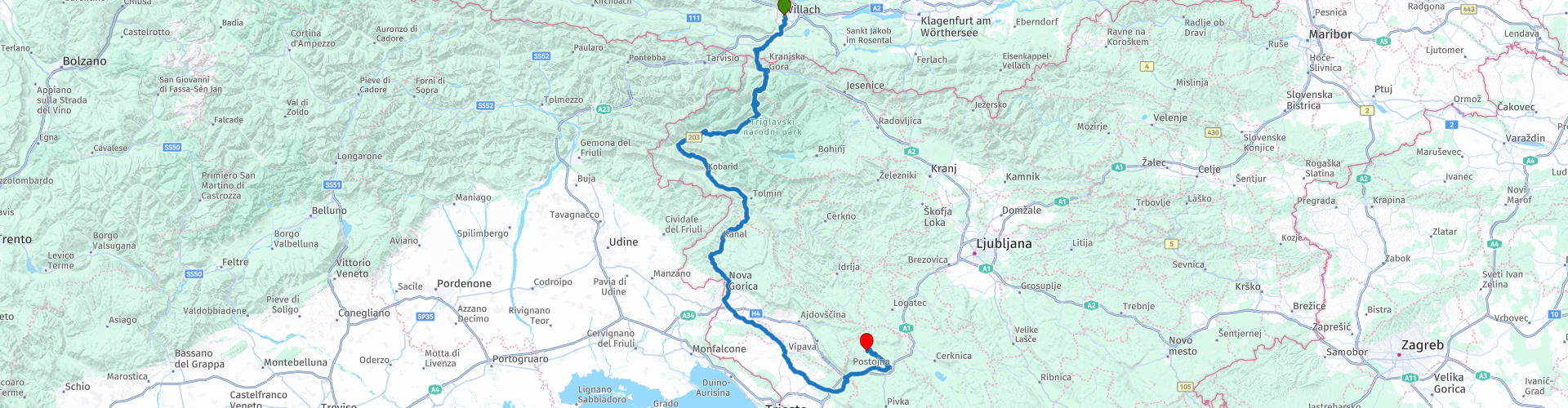
Villach in Austria to Postojna in Slovenia

This route was brought to you by:
RouteXpert Johan Starrenburg
Last edit: 27-12-2021
 Route Summary
  Share this route


Animation

Verdict


Duration
7h 44m

Mode of travel
Car or motorcycle

Distance
213.90 km

Countries


 RouteXpert Review
 The reason we start in Villach is because this is also the terminus of the car train that starts in Düsseldorf.
As mentioned, the journey starts in Villach.
Villach is located on the river Drau at 501 meters above sea level. Beautiful historic center, many sights and shops. The most famous landmark is the 14th century Gothic church of St.Jacob. You will also find many types of dining options here and it is great to go out in the evenings in the streets by the river. Outside the high season it is very quiet. The Ossiacher See is just outside the city. A large mountain lake with many recreational opportunities.
Secret during the cold war, open to the public since 2005, Austria's largest fortress system converted to a museum. From 1055 Austria was neutral and situated between the military alliances of NATO and the Warsaw Pact. This situation changed after the collapse of the Soviet Union in 1991. The purpose of these bunkers was to prevent foreign troops from entering the country. Most bunkers, connecting passages and combat positions are in their original state.
After a possible visit to the bunker museum, we soon approach the Austrian – Slovenian border crossing.
Lake Jasna is definitely worth taking a moment to think about and possibly have a drink or to photograph Lake Jasna. The lake is located in an idyllic alpine valley just before the first bends of the road to the mountain passage Vršič - the highest road passage in the eastern Julijske Alps Mountains (1611m). The water surface measures 2.2 ha.
The Russian street has cobblestones in the bends where the straights are paved with asphalt. The corners are sharp and especially in the rain some caution is in order in these corners.
After a number of beautiful bends we pass the highest Alpine pass in Slovenia. In the descent that follows, we again pass beautiful viewpoints and follow viewpoint Supca after having driven about 35 km.
A good moment to rest before we start the next 6 km with over 21 hairpin bends.
On the way from Vršič pass, follow the river Soča, passing by small gorge (Mala korita), you will come to Velika korita. Nice to walk around.
If you don't consider the Soča river in Slovenia to be the most beautiful river on the planet, you probably haven't seen it yet. She is nicknamed "Emerald Beauty" and the middle name is more than deserved. Many are breathless when they see the color. The colors are really incredible and they change through the seasons. Sometimes emerald green, sometimes aquamarine – and never boring.
The color comes from small particles of rock suspended in the water, also known as "rock flour", which reflect green and blue when struck by the light. As the Soča valley area comes mainly from limestone and marl deposits, the colors remain almost the same along the entire length.
Although mountain lakes and rivers are often seen from the same color, the Soča River is special because it retains its color for a very long time, from its source in the Trenta Valley to its end in the Adriatic Sea in Italy - river Soča Mouth Reserve.
Not far from Bovec, about 11 kilometers away if you drive towards the places Soča and Trenta, lies the gorge Velika Korita. This narrow gorge is 750 meters long and 15 meters deep.
Boka waterfall is Slovenia's most water-rich and mighty waterfall, with a total height of 144 meters and a width of 18 meters, it is also one of the most majestic waterfalls in Europe. The view of the vertical rock walls with the Boka waterfall in the middle is really striking. To view the Boka waterfall, start climbing on a clear path on the left side of the road just after the bridge (the right bank of the river from Boka).
The trail is quite steep but technically undemanding. The path ascends everywhere and comes near a steep wall from time to time, so be careful!
Views towards the waterfall open up and become more beautiful the higher you go. The great 'rocky' atmosphere will certainly captivate you. The round trip takes about 45 minutes and goes through rocky surroundings with beautiful views.
Grad Stanje is an old village that is ideal for a walk. It's really not big and there are signs everywhere with the details. Few tourists and in the courtyard of the castle there is a terrace where you can also eat and where there is a tourist office with a shop.
Almost at the end of the route there are two special places to visit: Postojna Caves and Predjama Castle (order tickets in advance).
First we pass the Postojna caves just outside Postojna. This is the only place where you can see the most precious brilliant in the form of a cave formation and also meet the baby dragons. Like the world above the surface, Postojna Cave has towering mountains, rushing rivers, and vast underground halls. It is a real challenge for explorers and the cradle of caving biology.
The route ends at Predjama Castle, the largest preserved castle in the world located in a cave. The castle hangs against the rock in the middle against a 123 meter high cliff. This is a castle like in fairy tales. The weathered walls, striped shutters next to the windows and the flag in the top make it seem as if the Predjama castle is still inhabited. But no. The infamous knight Erasmus, who carried out raids from here, has been dead for centuries. And all the families that lived here after him have since left as well. And yet it feels like a step back in time.
In the year 1274 is written for the first time about the castle of Predjama. The Patriarch of Van Aquileia had the castle built in Gothic style. In the centuries that followed, the Knights of Adelsberg expanded it further.
In the 15th century, the castle is put to the test. Erasmus van Lueg was at that time lord of the manor and a notorious robber baron. On one of his journeys, he turns the powerful Habsburg family into an enemy.
Erasmus flees and returns to Predjama Castle. It is besieged for a year, but Erasmus, to the surprise of his opponents, does not give up. In fact, he even sends gifts to his enemies. To get food and fresh water, the knight had a secret path built in the cave behind the castle.
But after a year of siege, Erasmus is betrayed by one of his subjects. While he is sitting on the toilet, the room is fired at with a cannonball. The invincible Erasmus does not survive.
In the 16th century, the castle gets a makeover. The Gothic castle will have the Renaissance appearance that it still has today. It remained inhabited until the Second World War. After that, the castle is nationalized and turned into a museum.
The castle is not only beautiful to look at from the outside, it is also fun to look around inside. In the rooms of the castle Predjama, some rooms are furnished with medieval furniture and there are dolls in medieval clothes. In addition, there is a portrait of knight Erasmus. The medieval weapons and armor are impressive.


 Links
Links  Usage
Usage Want to download this route?
You can download the route for free without MyRoute-app account. To do so, open the route and click 'save as'. Want to edit this route?
No problem, start by opening the route. Follow the tutorial and create your personal MyRoute-app account. After registration, your trial starts automatically.  Disclaimer
Use of this GPS route is at your own expense and risk. The route has been carefully composed and checked by a MyRoute-app accredited RouteXpert for use on TomTom, Garmin and MyRoute-app Navigation.
Changes may nevertheless have occurred due to changed circumstances, road diversions or seasonal closures. We therefore recommend checking each route before use.
Preferably use the route track in your navigation system. More information about the use of MyRoute-app can be found on the website under 'Community' or 'Academy'.

Carinthia
About this region
Carinthia (German: Kärnten [ˈkɛʁntn̩] (listen); Slovene: Koroška [kɔˈɾóːʃka] (listen)) is the southernmost Austrian state or Land. Situated within the Eastern Alps, it is noted for its mountains and lakes. The main language is German. Its regional dialects belong to the Southern Bavarian group. Carinthian Slovene dialects, forms of a South Slavic language that predominated in the southeastern part of the region up to the first half of the 20th century, are now spoken by a small minority in the area.
Carinthia's main industries are tourism, electronics, engineering, forestry, and agriculture. The multinational corporations Philips, Infineon Technologies and Siemens have large operations there.
Read more on Wikipedia
Carinthia's main industries are tourism, electronics, engineering, forestry, and agriculture. The multinational corporations Philips, Infineon Technologies and Siemens have large operations there.
View region
 Statistics
  35
35Amount of RX reviews (Carinthia)
 35186
35186Amount of visitors (Carinthia)
 4801
4801Amount of downloads (Carinthia)
 Route Collections in this region
 The 24 Most Beautiful Alpine Routes
The Alps, The Alps are a mountain range in Europe, stretching from the French Mediterranean coast in the southwest to the Pannonian Plain in the east. The area of the mountain range is more than 200,000 km².
In other words Passes and Mountain Roads!
Driving through the mountains is great! Especially over the mountain passes with hairpin bends and narrow winding roads. Every bend a different view where you can enjoy. There are many beautiful mountain passes in the Alps.
A selection that has also been incorporated into these routes:
The Stlevio Pass:
The Stelvio Pass, also known as Passo dello Stelvio, is mainly known for the stage in the Giro d'Italia. Due to the length and the difference in height, this pass is seen as one of the toughest tests in cycling. The Stelvio Pass reaches a maximum height of 2758 meters and is therefore one of the highest in the Alps. The pass connects the towns of Bormio and Prato Allo Stelvio. In winter the pass is closed due to heavy snowfall.
The Reschenpass:
The Reschenpass, also known as Passo di Resia, connects the Austrian state of Tyrol with the Italian province of South Tyrol. The pass reaches a maximum height of 1,504 meters and has been one of the most important north-south connections in the Alps in recent centuries. The pass was used long before Roman times. Along the way you will pass several highlights and historical relics. One of the highlights is the Reschensee. This lake was created after the construction of the dam and has completely submerged the village of Graun. The only thing that reminds of that is the clock tower in the middle of the lake.
Col du Galibier:
The French mountain pass Col du Galibier connects the towns of Saint-Michel-de-Maurienne and Briançon via the Col du Lautaret in the south and the Col du Télégraphe in the north. The mountain pass is part of the Tour de France and very much feared, due to the fact that it can only be reached via the other two mountain passes. The pass reaches a maximum height of 2646 meters. From there you can take a walk to the viewpoint at 2704 meters. You can admire the peaks of the Grand Galibier, Mont Blanc and La Meije here.
The Grossglockner High Alpine Road:
With a height of 3798 meters the Grossglockner is the highest mountain in Austria. To fully enjoy this impressive mountain, you can drive over the Grossglockner High Alpine Road and the accompanying pass. The route starts from Bruck am Grossglockner and ends in Heiligenblut. Of course you can drive in two directions. The pass reaches a maximum height of 2504 meters and is closed in winter due to heavy snowfall. Along the way you pass several stops with fun activities, information points, mountain huts and viewpoints. A visit to the Kaiser-Franz-Josefs-Höhe and Pasterzen Glacier is highly recommended.
The Col d'Izoard:
Just like the Col du Galibier, the Col d'Izoard is also part of a stage of the Tour de France. The mountain pass connects Briançon with the valley of the river Guil. The pass is partly located in the Regional Natural Park du Queyras and reaches a maximum height of 2360 meters. What is special about the Col d'Izoard is the barren and rocky landscape. Sometimes it feels like driving a car over the moon! Along the way you can stop at several points to enjoy the beautiful view.
The Bernina Pass:
The Bernina Express is one of the most famous rail trains in Switzerland and the Alps. The route is beautiful and partly included on the UNESCO World Heritage List. Parallel to the railway lies the Bernina pass, which connects the Veltlin valley with the Egandin valley. This beautiful Alpine road has a total length of 56 kilometers and reaches a maximum height of 2328 meters. Along the way you can enjoy views of the Morteratsch Glacier.
The Sella Pass:
The Sella Pass, also known as Passo di Sella, takes you over one of the most impressive mountain ranges in the Dolomites: the Sella massif. The pass connects Valle di Fassa with Val Gardena and reaches a maximum height of 2236 meters. At this height is also the border of the Italian provinces of Trentino and Bolzano. Along the way you can enjoy the view of this spectacular mountain world. Admire, for example, the three peaks of the Sasso Lungo massif, the Sella massif or the peaks of the Marmolada. You can also drive the Sella pass in combination with the Gardena pass, Pordoi pass and Campolongo pass.
The Grimsel Pass:
The Grimsel Pass connects Goms in Wallis with the Halis Valley in the Bernese Oberland. The pass reaches a maximum elevation of 2165 meters and is closed in winter due to snowfall. Over the centuries, the mountain pass has played an important role in trade between Switzerland and Italy. Now it is mainly the reservoirs that have an important function. These are used to generate electricity. The landscape you drive through is rugged, rocky and impressive. On top of the pass is a hotel and a restaurant with a special marmot park. The Dodensee (Totensee) is also located here. This lake owes its name to the many soldiers who died in the time of Napoleon.
The Gotthard Pass:
The Gotthard Pass, also known as Passo del San Gottardo and Saint Gotthard, connects the Swiss towns of Airolo and Andermatt. The mountain pass and associated tunnel are especially known among holidaymakers driving from Switzerland to Italy. But where the majority opt for the tunnel, it is precisely the pass that really completes the holiday. The Gotthard Pass has a length of about 26 kilometers and reaches a maximum height of 2106 meters. The route is beautiful and takes you along old villages and beautiful views.
The Silvretta High Alpine Road and Silvretta Pass:
The Paznaun Valley in Tyrol and the Montafon in Vorarlberg are connected by the Silvretta High Alpine Road. The route has a length of 22.3 kilometers and leads from Galtür to Partenen in 34 hairpin bends, via the 2032 meter high Bielerhöhe. The Silvrettasee is also located at this point, where you can enjoy a lovely walk. The pass is closed in winter due to snowfall.
The Simplon Pass:
Just like the Gotthard Pass, many holidaymakers also travel over the Simplon Pass every year. This mountain pass connects the Rhone Valley in the canton of Valais with the Valle d'Ossola in Piemonte. The pass is open all year round and reaches a maximum height of 2005 meters. Along the way you pass a number of buildings, including the well-known Simplon Hospiz from 1825. The hospiz is managed by the monks of St. Bernard. From the highest point on the pass, all kinds of hiking routes are possible and you will also come across a hotel where you can spend the night.
The Gerlos Pass:
The Gerlos Pass connects the Salzach Valley in the Salzburgerland with the Zillertal Valley in Tyrol. The pass is part of the Gerlos Alpenstraße and runs right through the Hohe Tauern National Park. Along the way you can enjoy beautiful views of the surroundings. The pass has a length of 12 kilometers and reaches a maximum height of 1531 meters. A ride over the Gerlos Pass can be ideally combined with a visit to the Krimmler Wasserfälle.
The Great St. Bernard Pass:
The Great St. Bernard Pass, better known as Col du Grand Saint Bernard, connects the Italian province of Valle d'Aosta with the Swiss canton of Valais. The pass is one of the highest in Switzerland and reaches a maximum height of 2469 meters. Like a number of other mountain passes in this list, the Great St. Bernard Pass has also been used as a connecting road for centuries. The pass is named after the St. Bernard dogs that used to help stranded travelers along with the monks. The pass is closed in winter.
The Timmelsjoch High Alpine Road:
The Timmelsjoch High Alpine Road connects the towns of Sölden in the Ötztal and Meran in South Tyrol. Tolls must be paid on the Hochgurgl - Moos route. Via a mountain road with about 60 hairpin bends you drive through a beautiful mountain world. With the Timmelsjoch Experience you can learn more about the history, the road and the environment via various stations. You can also visit the Top Mountain Crosspoint museum.
Col de l'Iseran:
With a maximum pass height of 2770 meters, the Col l'Iséran is one of the highest mountain passes in the Alps. The pass connects Bourg-Saint-Maurice with Bonneval-sur-Arc. Via a road full of hairpin bends you pass, among other things, Val-d'Isère and a side valley of the Maurienne that lies entirely in the National Park de la Vanoise. You can spot animals such as marmots and chamois and there is also a restaurant with a chapel on top of the pass.
The Gavia Pass:
The Gavia Pass (Italian Passo di Gavia) is a mountain pass in the Italian Alps, in the Lombardy region.
It is one of the highest pass roads in Europe. The road leads through the unspoilt Stelvio National Park. The road was built in the First World War to supply Italian soldiers who fought in the Italian-Austrian border area. The pass height is one of the most beautiful in the Alps. Here is the large Lago Bianco with, to the north, the mountain San Matteo (3684 meters). Lago Nero is slightly lower on the south side of the pass. Here the mountain group of the Adamello determines the view. There are many well-marked walks in the area. During the winter the pass is closed due to the heavy snowfall. The pass is often closed until May and June due to the large amount of snow.
Promoter has made a selection of the 24 Most Beautiful Alpine routes that they have set out in recent years.
The routes go through:
France
Austria
Switzerland
Italy
The most beautiful roads, the most beautiful views, the most beautiful viewpoints. The highest mountains, the fastest descents, hairpin bend after hairpin bend, you name it you can't get enough of it.
If you go on holiday in this region, take advantage of it, ALL routes in this collection have been checked and made equal for TomTom, Garmin and MyRoute-app Navigation by a MyRoute-app RouteXpert.
Have fun with this collection and while driving one of these routes. Enjoy all the beauty that the Alps and the Dolomites have to offer. Click on “View route” to read the review of the chosen route.
I would like to hear your findings about the route(s).
View Route Collection
The 12 most beautiful car and motorcycle routes in Carinthia
“Motorradland Kärnten” where you feel so wonderfully welcome as a motorcyclist!
Own website for motorcyclists, own curated routes, hotels, campsites and guest houses with attention for motorcyclists, a wonderful area where motorcyclists are very popular.
Kärnten or Carinthia, at the crossroads of the Germanic, Slavic and Roman worlds. Three cultures within a few kilometres, southern flair, culinary delights, cross-border tours. Breakfast in Italy, lunch in Slovenia, dinner in Austria - all in one day. Experience the diversity in the borderless Alps-Adriatic region, the area for motorcyclists.
Extensive day trips on winding mountain paths, romantic panoramic routes and beautiful lakes, here the 12 TOP routes Kärnten / Carinthia. Enjoy!
View Route Collection