R03 NSW Canberra to Jenolan

This route was brought to you by:
RouteXpert Hans van de Ven (Mr.MRA)
Last edit: 21-02-2020
 Route Summary
 Australia is very big; 8 million km2, that is more than 226 times larger than the Netherlands! Has a diversity of flora and fauna; the most diverse types of plants, trees and animals, especially birds and a lot of typical Australian marsupials, that you won't find anywhere else in the world!
Enormous enjoyment of all the beautiful things: From the evergreen tropical rain forests to the vast Outback; from the desert to the countless and tranquil idyllic palm beaches; from the winter sports areas in the southeast to the bustling and impressive millions of cities of Melbourne, Sydney and Perth.
You will see and experience it all in this great tour through Australia, a tour you will never forget!
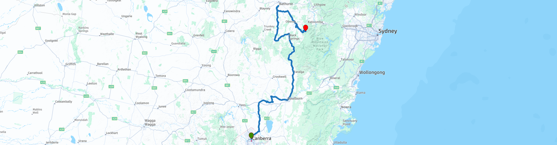
Starting point: Canberra, Peppers Gallery Hotel.
End point: Jenolan, Jenolan Caves House
The route has been made the same for TomTom, Garmin and MyRoute-app Navigation users.
ATTENTION: LEFT DRIVING!
 Share this route


Animation

Verdict


Duration
5h 37m

Mode of travel
Car or motorcycle

Distance
421.92 km

Countries

 RouteXpert Review
 The Jenolan Caves ("Jenolan Caves") are a series of caves in the Blue Mountains. They are the best known of several similar caves in the country's limestone, and the oldest discovered open caves in the world. They do not contain fossils of great interest, but the stalactite formations are sometimes pure white and exceptionally beautiful. Many parts of the cave are easily accessible to tourists.
Jenolan Caves attract more than 250,000 visitors a year, making it one of the most popular tourist locations in New South Wales. Nine of the "dark caves" in the area are open for fixed trips, and many others for special trips. According to scientists, the Jenolan Caves are also the oldest open caves in the world. Large parts of the extensive cave system can only be reached by experienced researchers, especially those along the underground river system. But there are 10 caves in Jenolan that are used for regular tourism.
Lucas Cave: discovered in 1860 and the most popular cave. The cave is named after the local politician John Lucas, who worked to preserve the caves in 1860. The cave contains several large rooms including the Cathedral, more than 50 meters high. This room is actually used from time to time for wedding ceremonies.
River Cave: discovered in 1903. The most extensive show cave of Jenolan. Contains some of the most famous features including the Minaret, the Grand Column and the Queen's Canopy. Until 1923, when a concrete bridge was built, the river had to be crossed by boat.
Chifley Cave: discovered in 1880, after which electrical light was installed almost immediately. Was known until 1952 as the Left Imperial Cave. Two of the rooms in this cave are covered with colored lighting. The Chifley Cave is probably the first of the caves that was illuminated with electric light.
Imperial Cave: discovered in 1879, this is the easiest accessible cave for tourists. One of the few caves in the complex that shows signs of fossils, as well as bones of the Tasmanian devil.
Orient Cave: discovered in 1904. This cave was not open to the public until 1917. The cave contains some of the largest formations of the complex, and was steam cleaned in 1968 to preserve these formations. Until 1954 the cave could only be reached via the River Cave.
Ribbon Cave: discovered at the same time as the Orient Cave. Originally part of the same tour that also visited the Orient Cave, but now part of a separate tour. Is only 60 meters long, but richly decorated.
Pool of Cerberus Cave: discovered in 1903 and originally known as the Skeleton Cave due to the presence of a wallaby skeleton near the entrance. This cave is a forearm of the River Cave. The most important formations here are the Bath of Venus and part of the underground river system.
Jubilee Cave: discovered in 1893. The Jubilee Cave is the longest cave, and therefore takes the most time during a tour. Furthermore, the cave is somewhat isolated from the others.
Temple of Baal Cave: discovered in 1904. The Temple of Baal Cave consists of only two rooms, one of which is dominated by the 9 meter high scarf formation called the Angel's Wing. The cave is also famous by a formation known as Helictites. The cave got its name when a scout saw inside two "altars".
Nettle Cave: this cave lights between the Grand Arch and the Devils Coach House. The cave owes its name to the stinging nettles that grow there. In December 2006, the cave was reopened for the public as for an audio tour.
The entrance to the Nettle Cave, circa 1888.
The caves (with the exception of the Nettle Cave) were created from a "hub" formed by the Grand Arch, a natural tunnel.
In addition to the caves mentioned above, there are a few caves that are only accessible for special tours.
Elder Cave: discovered in 1848. The Elder Cave was the first cave of the Jenolan that was found and opened to tourists. It was later decided that it was too difficult to adapt the cave for mass tourism, and the tours were stopped. In the 90s the cave was reopened for special tours.
Aladdin Cave: was first explored in the hope of finding a shorter path to the Jubilee Cave.
Jersey Cave: an extension of the Elder Cave. One of the features in this cave is a fossil of a marsupial skeleton.
Arch Cave: This cave is above the Nettle Cave, and part of it can be seen from the Devils Coach House. The entrance to this cave is the basis of the Carlotta Arch.
In Canberra you can do some shopping at the supermarket, so that you can stop for a picnic on one of the many picnic areas. You leave Canberra via the Federal Highway, about 20 KM further you leave it again to drive through New South Wales. You pass through several small towns, nice to take a picture of each town for later. Refueling and a stop for coffee are planned in Goulburn. Goulburn is approximately 100 kilometers north of Canberra. It is the capital of the Goulburn Mulwaree Council. Goulburn was founded in 1833 and had 20,127 inhabitants in 2006. The place is the center of an area known for its sheep and wool. The next fuel stop is in Perthville, after a 330 km drive. Perthville is located on the Central Plateaus, about 10 kilometers from the regional city of Bathurst. The city has evolved over time due to road improvements and is a satellite suburb of Bathurst.
After refueling in Perthville it is still about 85 KM to the end point in Jenolan, where you will be amazed by the scenery in the coming days.
This route, rated with 4 stars, is mainly about beautiful roads, through some small towns and beautiful nature reserves.
General info:
New South Wales is a state of Australia with Sydney as its capital, and is often abbreviated to NSW. The three most important cities are, from north to south, Newcastle, Sydney and Wollongong, which are all on the coast. Other cities are Albury, Broken Hill, Dubbo, Tamworth, Armidale, Lismore, Nowra and Coffs Harbor.
The state is located on the east coast of the continent, north of the state of Victoria and south of the state of Queensland. In the west it borders South Australia. The coast borders the Tasman Sea. New South Wales has two federal enclaves: the Australian Capital Territory (ACT) and the Jervis Bay Territory.
New South Wales can be physically divided into four parts:
A narrow coastal strip, with a climate whose temperature varies from temperate on the extreme south coast to subtropical on the Queensland border.
The mountainous areas of the Greater Australian Separation Mountains and the highlands that surround it, such as the Southern Highlands, Central Tablelands and the regions of New England. Even though the mountain walls are not very steep, many mountain tops exceed 1000 meters, of which Mount Kosciuszko reaches 2229 meters as the highest peak.
The agricultural plains, which make up a large part of the area of the state. These areas are much less densely populated than the coast. This part includes the Riverina region.
The dry, desert-like plains in the far north-west of the state, which are unsuitable for settlements of any size.
It is the oldest colony of the former Australian colonies of the United Kingdom. The colony was founded in 1788 and originally included much more of the Australian mainland. At that time, the western half of the colony was called New Holland and the eastern half was New South Wales. New Holland was controlled from Sydney.
During the nineteenth century large areas were separated around the British colonies Van Diemen's Land (Tasmania) (1825), Victoria (1851), Queensland (1859) and South Australia (1836) (which at that time also included the Northern Territory) to shape. These colonies and Western Australia voted in 1901 to continue together as the Commonwealth of Australia.
Tourist attractions in the state include; The Blue Mountains, west of Sydney, a national park including the Three Sisters rock formation; The Hunter Valley, 150 km north of Sydney, the oldest wine region in Australia. The Snowy Mountains, on the border with Victoria, a popular ski resort, and the capital, Sydney.


 Links
Links  Usage
Usage Want to download this route?
You can download the route for free without MyRoute-app account. To do so, open the route and click 'save as'. Want to edit this route?
No problem, start by opening the route. Follow the tutorial and create your personal MyRoute-app account. After registration, your trial starts automatically.  Disclaimer
Use of this GPS route is at your own expense and risk. The route has been carefully composed and checked by a MyRoute-app accredited RouteXpert for use on TomTom, Garmin and MyRoute-app Navigation.
Changes may nevertheless have occurred due to changed circumstances, road diversions or seasonal closures. We therefore recommend checking each route before use.
Preferably use the route track in your navigation system. More information about the use of MyRoute-app can be found on the website under 'Community' or 'Academy'.