R32 WA Kalbarri to Perth

This route was brought to you by:
RouteXpert Hans van de Ven (Mr.MRA)
Last edit: 16-07-2020
 Route Summary
 Australia is very large; 8 million km2, which is more than 226 times larger than the Netherlands! Has a diversity of flora and fauna; the most diverse types of plants, trees and animals, especially birds and many typical Australian marsupials, which you will not find anywhere else in the world!
Enjoy all the beauty: From the evergreen tropical rainforests to the vast Outback; from the desert to the countless and peaceful idyllic palm beaches; from the winter sports areas in the southeast to the bustling and impressive metropolis of Melbourne, Sydney and Perth.
You will see it all and experience it in this amazing tour through Australia, a tour to remember!
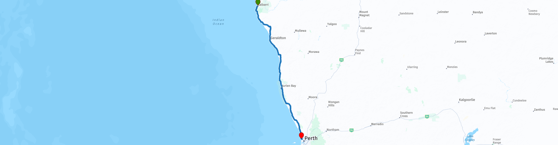
Starting point: Kalbarri, Big River Ranch
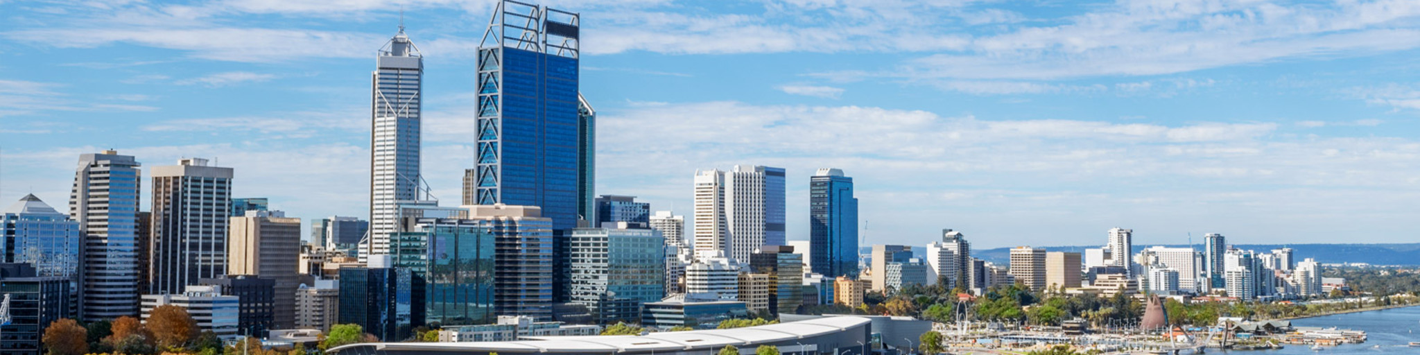
End Point: Perth, Rendezvous Hotel Perth Scarborough
The route has been created for TomTom, Garmin and MyRoute-app Navigation users.
ATTENTION: DRIVE LEFT!
 Share this route


Animation

Verdict


Duration
7h 1m

Mode of travel
Car or motorcycle

Distance
585.49 km

Countries

 RouteXpert Review
 Another beautiful ride with a regular stop to take some pictures, starting just after the start in Kalbarri, no less than 3 viewpoints on the coast, stopping for a while and shooting some nice pictures. Then, after about 60 KM, the Hutt Laggon appears. The Hutt Lagoon is a salt lake in the sea, 2 kilometers north of the mouth of the Hutt River. Sometimes bright bubblegum pink, sometimes lilac, and sometimes even red, the waters of the Hutt Lagoon can be an extraordinary sight of the ride between Kalbarri and Port Gregory. Go before sunset and watch the colors change. It is the extremely high salt content that gives the lagoon its unusual hue and the vibrancy changes with the seasons and time of day. The best time to visit is on a clear day, mid-morning or sunset. There are a number of places to view this natural phenomenon along Port Gregory Road.
After all this beauty, it is time for coffee and petrol, for this you can stop at the Puma 440 Roadhouse along the route. After coffee, the towns start to sign up at a rapid pace, a sign that you are nearing Perth.
In the town of Leeman, refuel again, eat and take some pictures, in the town of Green Head, you have to take a photo. Then the Nambung National Park looms, thousands of huge limestone pillars rise from the shifting yellow sand of the Pinnacles Desert, you imagine yourself on the set of a science fiction film.
Then the final sprint of 100 KM to the end of this route, Perth. Refuel and enjoy the view, pool, beach and of course Perth itself in your hotel.
This route also goes through the outback, these are the regions that are far from civilization. The outback covers nearly three-quarters of Australia and mainly covers the Northern Territory and Western Australia, and parts of the states of Queensland, New South Wales and South Australia.
The term outback includes various landscapes and climatic zones. Large parts of the outback in Western Australia are inaccessible: sometimes there is no rain here in years, while in summer the temperature rises above 50 ° C. The Queensland outback, on the other hand, consists partly of tropical rainforest.
The characteristics of the outback are:
- Only a few paved roads are present. Farms (stations) are usually located along sandy paths that can only be driven with off-road vehicles. It is no exception when a farm is 80 kilometers from the paved road.
- Farms are self-catering. It is no problem if a supermarket cannot be visited for weeks.
- Settlements with a few houses, a gas station, a supermarket, a garage, a bank and restaurants are hundreds of kilometers apart.
- Children receive remote education via radio (School of the Air) and the Internet.
- In the event of serious illness and accident, the Royal Flying Doctor Service (RFDS) is called upon.
Camels were imported from the Middle East in 1870. They live partly on farms, partly in the wild.
- Of the approximately 300,000 Aborigines (approximately 1.5% of Australia's total population), approximately 20% live in the outback, most of them in reservations.
This 4-star rated route is on good through roads, with occasional dirt roads. Watch out for the so-called "Road Trains", a road train is a truck combination consisting of a tractor or tow truck, combined with several trailers or semi-trailers. Off-road, road trains are not subject to vehicle length limits. In mining at open-pit quarries, combinations up to 100 meters in length are used. A beautiful route through the vast West of Australia, again with beautiful views that will certainly provide beautiful photos. And then Perth, the capital of Western Australia, definitely a place where you want to stay for at least 1 week after enjoying the last 10 rides and exploring this metropolis.
General info:
Western Australia (Western Australia) covers the westernmost part of the Australian continent. The first Dutch people who set foot ashore called it New Holland.
At 2,529,875 km², it is Australia's largest state in area and covers roughly one third of the continent. Still, in 2016, only about 2,474,410 inhabitants lived there. Western Australia is surrounded by the Indian Ocean in the south, west and north. To the east, the state borders the Northern Territory and South Australia; Surveyor General's Corner is where the three sub-areas meet.
The northernmost point is Cape Londonderry and the northernmost place is Wyndham. The southernmost point is 'Torbay Head' and the southernmost point is Albany. The westernmost point is Steep Point and the westernmost point is Denham. The entire 1,862 kilometer long eastern border of Western Australia is the easternmost point and Eucla the easternmost point. The highest location at about 750 meters is the mining village of Tom Price and the highest mountain is the 1,249 meters high Mount Meharry in the Hamersley Mountains.
The 865 kilometers long Gascoyne and the 820 kilometers long Murchison are the two longest rivers in Western Australia. The largest lake, of which 80% is located in Western Australia and 20% in the Northern Territory, is 3,494 km² of Mackay Lake. The second largest lake is the 1,980 km² large 'Lake Barlee'. Western Australia is divided into a dozen administrative regions. There is the Perth City Region which is located on the west coast in the south. About three quarters of the total population of the state lives here.
The Aborigines have lived in western Australia for more than 40,000 years. The first Europeans probably arrived by accident, they were shipwrecked on their way to the Dutch East Indies. The Dutch seafarer Dirck Hartog was probably the first European to set foot ashore. In October 1616 he left a pewter plate with the inscription '1616 den october 25 has arrived here', on the island in front of Shark Bay that now bears his name. Australia was then called New Holland. In 1696 Willem de Vlamingh landed on Dirk Harto Island, where he replaced the plate with a new one. He took back the old and this can now be seen in the Rijksmuseum in the Netherlands. However, this did not stop, the barren land was not commercially interesting.
Only in 1826 did the British claim the western part of the continent. They founded Fredrickstown, now Albany, and three years later the Swan River Colony, now Perth. The driving force behind the colonization of western Australia was James Stirling. The country had little to offer and the first settlers had a hard time. Explorations were undertaken in all directions from Perth. The early settlers tried to farm, grow sheep, and sell vegetables to American whalers, or to do whaling themselves. From the 1840s sandalwood was cut to market it in China and horses were bred for the Indies.
From 1850, Western Australia became a prisoner colony due to a lack of labor. They built roads and public buildings or were employed as workers in extensive livestock farming. Around 1870, earnings were also obtained from pearl fishing and from the felling of the huge deciduous forests. The first railways were constructed to carry the wood. But the Western Australian population and economy only really started to grow after gold was found in the 1880s, first near Halls Creek, along the Murchison River, in the Yilgarn and Pilbara, and finally in the eastern goldfields.
Thanks to the gold rush, there was money to invest in public buildings, ports, education and public transport. CY O'Connor designed the port of Fremantle and, at the turn of the century, constructed a more than 500 km long water pipeline to Kalgoorlie. Thanks to this pipeline, the new drought-resistant grain variety 'Federation' and the introduction of superphosphates, agricultural development in the Wheatbelt region was made possible. During the First World War, about 10% of the population moved to the front. After the war, through Soldier Settlement Schemes and similar non-military programs in the southwest of the state, farms were started and a milk industry developed. The 1930s crisis led to innovation and grain was then shipped in bulk. The automobile started to advance and work was carried out on the road network.
Western Australian industrialization did not actually begin until World War II. Refineries and blast furnaces were started and weapons were produced. Returning soldiers after the war caused a boom in construction. However, the railway network was gradually phased out by the rise of the automobile. In the 1950s, agriculture in the south of the Goldfields-Esperance region became possible after it emerged that a shortage of trace elements in the subsoil could be addressed. In the 1960s, oil was found around Barroweiland and the pre-war ban on iron ore exports was lifted. From the 1980s, the Western Australian economy and prosperity started to seriously increase thanks to Asian economic growth and demand for raw materials and agricultural products. Since then, the state has been confronted with environmental problems. Salinization is occurring in agricultural areas and climate change is also being felt. In the dry areas there is more precipitation and in the wetter southwest less precipitation.
Western Australia is largely desert and semi-desert, including the Great Sand Desert in the north, the Little Sand Desert and the Gibson Desert in the center and the Great Victoria Desert in the southeast. A small portion of the Tanami Desert is located in the northeast. There are also the Kimberley, a weathered plateau in the far north and the Pilbara, a rich mineral area in the west. The vast Nullarbor Plain in the southeast is shared with South Australia.
The southwestern part of the state, consisting of the South West and Great Southern regions, consisted mainly of huge deciduous forests cleared for timber production and / or to create farmland in the 19th and 20th centuries. At the beginning of the 21st century, the landscape consists of remains of forest, agricultural land and orchards and vineyards. The landscape of the more northerly and easterly regions of Wheatbelt and the southern part of the Goldfields-Esperance region consists mainly of wide plains with grain fields.
Western Australia is an important mining area. More than 1,000 mines are active and some 50 different minerals are extracted from the ground. In the 12 months to July 1, 2013, AU $ 102 billion in minerals, metals, and oil and gas was produced, and this was the third consecutive year that the value surpassed $ 100 billion. The main product is iron ore, in 2012-13 more than 500 million tons were exported, worth $ 56 billion. Petroleum products, including petroleum, LNG, natural gas condensate and LPG, were valued at $ 24 billion. Gold occupied third place with a value of $ 9 billion. The share of mining products in Western Australia's total exports was nearly 90% and was just under half of Australia's total exports. Almost half of the goods go to China, followed by Japan with a fifth of Western Australian exports.


 Links
Links  Usage
Usage Want to download this route?
You can download the route for free without MyRoute-app account. To do so, open the route and click 'save as'. Want to edit this route?
No problem, start by opening the route. Follow the tutorial and create your personal MyRoute-app account. After registration, your trial starts automatically.  Disclaimer
Use of this GPS route is at your own expense and risk. The route has been carefully composed and checked by a MyRoute-app accredited RouteXpert for use on TomTom, Garmin and MyRoute-app Navigation.
Changes may nevertheless have occurred due to changed circumstances, road diversions or seasonal closures. We therefore recommend checking each route before use.
Preferably use the route track in your navigation system. More information about the use of MyRoute-app can be found on the website under 'Community' or 'Academy'.