Trappisten proeven in de Ardennen

This route was brought to you by:
RouteXpert Stijn Claus
Last edit: 27-06-2021
 Route Summary
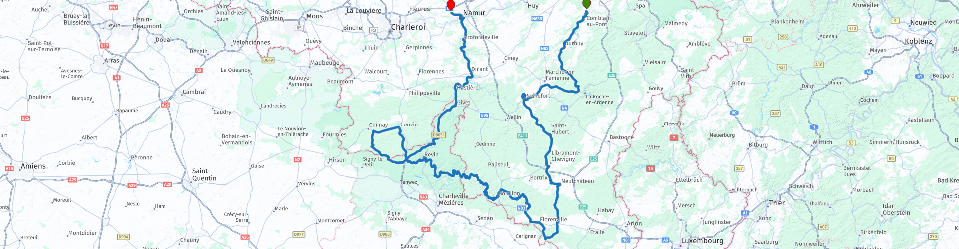
 On the way we also visit the cities of Durbuy, Bouillon and Dinant.
This route can be driven on a day or on several days. However, to fully enjoy the sights on the way, it's best to take two days for this trip.
The route can be split up according to your wishes, there are more than enough accommodation options along the way.
The route mainly follows the banks of the Ourthe and the Meuse. We follow secondary roads, but also much smaller roads. The cornering in this route in more than average. The quality of the road varies, as is often the case in the Ardennes from good to bad.
 Share this route


Animation

Verdict


Duration
7h 52m

Mode of travel
Car or motorcycle

Distance
443.03 km

Countries


 RouteXpert Review
 Along the banks of the Ourthe, Durbuy, La Roche and Marche and Famenne we arrive in Rochefort. Here lies the Abbey Notre-Dame de Saint-Rémy, or the Abbey of Rochefort.
The Notre-Dame de Saint-Rémy Abbey in Rochefort belongs to the Cistercians of the strict observance, better known as the Trappists. The foundation deed was granted in 1230 and the abbey was named Secours de Notre-Dame.
In 1899 they established a small brewery. The brewery became the main source of income for the abbey.
Rochefort is one of the abbeys that can use the name 'Trappist beer'.
From Rochefort the route descends further to the south where we cross the Notre-Dame d'Orval Abbey.
The abbey settled here in 1132. The monastery is known for its history and spiritual life, but also for its Trappist beer and typical Trappist cheese.
The route leaves Orval and meander along the Semois further towards Bouillon.
Bouillon is dominated by the medieval fortress of Godfrey of Bouillon and the old town center.
The origins of Bouillon would date from the 8th century. Its existence is confirmed from 988.
The city lies on a meander of the Semois at an altitude of 383 meters above sea level.
The route follows the banks of the Semois further towards France. We pass a number of spectacular views such as the Tomb of the Giant, the panorama of Frahan in Rochehaut and Les Dames de Meuse to arrive at the Abbey Notre-Dame de Scourmont.
The abbey was founded in the summer of 1850 by a small group of monks on the wild highland of Scourmont near Chimay. A farm, a brewery and a cheese factory will be built around the monastery. The first Chimay beer was brewed in 1862. In 1876 the Trappist monks of Chimay tried an old recipe to make a semi-hard cheese, which they allowed to ripen in the cellars of the abbey.
Via France and the banks of the Meuse, we drive via Dinant towards Namur and the terminus of this route.
The end point of this route is at the entrance of the E42 Liège-Charleroi motorway.
Attention: as a driver, the limit is 0.5 per mille alcohol or 0.22 per mil per liter of exhaled air. In case of violation, you will therefore lose your driver's license.


 Links
Links  Usage
Usage Want to download this route?
You can download the route for free without MyRoute-app account. To do so, open the route and click 'save as'. Want to edit this route?
No problem, start by opening the route. Follow the tutorial and create your personal MyRoute-app account. After registration, your trial starts automatically.  Disclaimer
Use of this GPS route is at your own expense and risk. The route has been carefully composed and checked by a MyRoute-app accredited RouteXpert for use on TomTom, Garmin and MyRoute-app Navigation.
Changes may nevertheless have occurred due to changed circumstances, road diversions or seasonal closures. We therefore recommend checking each route before use.
Preferably use the route track in your navigation system. More information about the use of MyRoute-app can be found on the website under 'Community' or 'Academy'.
;_vue_de_la_partie_occidentale_du_château-fort_(XIIIe–XIX_siècles).jpg/1280px-Bouillon_(Belgique);_vue_de_la_partie_occidentale_du_château-fort_(XIIIe–XIX_siècles).jpg)
Luxembourg
About this region
Luxembourg (French: Luxembourg [lyksɑ̃buʁ] (About this soundlisten); Dutch: Luxemburg [ˈlyksəmˌbʏrx] (About this soundlisten); German: Luxemburg [ˈlʊksəmbʊʁk] (About this soundlisten); Luxembourgish: Lëtzebuerg; Walloon: Lussimbork), also called Belgian Luxembourg, is the southernmost province of Wallonia and of Belgium. It borders on the country of Luxembourg to the east, the French departments of Ardennes, Meuse and Meurthe-et-Moselle to the south and southwest, and the Walloon provinces of Namur and Liège to the north. Its capital and largest city is Arlon (Luxembourgish: Arel, Dutch: Aarlen), in the south-east of the province.
It has an area of 4,459 km2 (1,722 sq mi), making it the largest Belgian province. With around 285,000 residents, it is also the least populated province, with a density of 64/km2 (170/sq mi), making it a relatively sparsely settled part of a very densely populated region.
It is significantly larger (70%), but much less populous than the neighbouring Grand Duchy of Luxembourg. About eighty percent of the province is part of the densely wooded Ardennes region. The southernmost region of the province is called Gaume or Belgian Lorraine (main city: Virton).
The Arelerland or Arlon region (in red on the map of arrondissements, below) bordering the neighbouring Grand-Duchy of Luxembourg has the particularity that many of its residents have historically spoken Luxembourgish, a language closely related to German, rather than the French or Walloon spoken elsewhere in the province.
The province was separated from the neighbouring Luxembourg by the Third Partition of Luxembourg, de jure in 1830–31 by the Conference of London dealing with the consequences of the Belgian Revolution of 1830, de facto in 1839, after William I, King of the Netherlands and Grand-Duke of Luxembourg, agreed to its decisions and thus the province was given to the newly created Kingdom of Belgium.
Read more on Wikipedia
It has an area of 4,459 km2 (1,722 sq mi), making it the largest Belgian province. With around 285,000 residents, it is also the least populated province, with a density of 64/km2 (170/sq mi), making it a relatively sparsely settled part of a very densely populated region.
It is significantly larger (70%), but much less populous than the neighbouring Grand Duchy of Luxembourg. About eighty percent of the province is part of the densely wooded Ardennes region. The southernmost region of the province is called Gaume or Belgian Lorraine (main city: Virton).
The Arelerland or Arlon region (in red on the map of arrondissements, below) bordering the neighbouring Grand-Duchy of Luxembourg has the particularity that many of its residents have historically spoken Luxembourgish, a language closely related to German, rather than the French or Walloon spoken elsewhere in the province.
The province was separated from the neighbouring Luxembourg by the Third Partition of Luxembourg, de jure in 1830–31 by the Conference of London dealing with the consequences of the Belgian Revolution of 1830, de facto in 1839, after William I, King of the Netherlands and Grand-Duke of Luxembourg, agreed to its decisions and thus the province was given to the newly created Kingdom of Belgium.
View region
 Statistics
  39
39Amount of RX reviews (Luxembourg )
 22578
22578Amount of visitors (Luxembourg )
 8235
8235Amount of downloads (Luxembourg )
 Route Collections in this region
 Route collection MRA NAVIGATION GRAND TOUR 2019
MRA NAVIGATION GRAND TOUR 2019 in short:
From 2019, MyRoute-app organizes every year the "MyRoute-app Navigation Grand Tour" exclusively for MyRoute-app Navigation users. During the Grand Tour you drive 4 routes during the calendar year. A few commands are included in each route. Participants who capture all 4 tracks via MyRoute-app Navigation have the chance to win a great prize. In 2019 we had chosen the 2nd World War as the theme for the 4 routes.
The routes and the assignments:
As mentioned, the theme of 2019 was the 2nd World War. A loaded theme, you are confronted with the dual nature of humanity; the willingness to kill for an ideology, we are better than them, cruelty, slaughter, but also heroism and sacrifices, would it ever change? I myself am very interested in world history, I have even studied it for a year at the university and certainly the 1st and 2nd world war have my interest. So it was no task to put together the routes, drive yourself and come up with the assignments.
Have fun driving these beautiful and interesting routes with a loaded theme!
View Route Collection
5 tours in Belgium in flat Flanders the hills of the Pays des Collines and the Ardennes
Those who like a winding and hilly course, along many small lanes with little to no traffic, will certainly find what they are looking for in the Pays des Collines, the region east and south of Ronse.
Between Diksmuide and Ypres there are many commemorative monuments of the First World War. In Vinkt in East Flanders, the monument commemorates the massacre that took place in May 1940.
Along rural quiet roads you can taste the history of World War I and II.
Marche-en-Famenne is an excellent starting point to thoroughly explore this plateau, which is cut by rivers and strewn with coniferous forests. The real Ardennes are the most hilly areas of Belgium behind the Meuse. Nature plays an all-important role on this trip.
In addition to the Ardennes, the route with start and end point in Huy also goes through a part of Condroz and Famenne. The Condroz, where wooded hills and valleys alternate, and the Famenne, which makes the transition to the Ardennes plateaus. In the summer it is wonderful motorcycling in the vast forests. You will not only enjoy the natural beauty, but you will also pass numerous castles, wild flowing Ardennes rivers, quiet villages and authentic tourist towns.
The tour from Namur runs through the Meuse area where you discover that the tributaries of the Meuse are of picturesque beauty. You will pass a large number of castles and fortresses. The roads along the Maas are busy arterial roads. But as soon as you can you will look for the smaller roads that are immediately a lot quieter and take us through forests and meadows.
View Route Collection