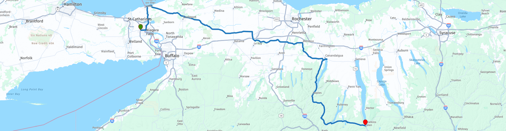
Niagara Falls to Watkins Glen visiting The Finger Lakes

This route was brought to you by:
RouteXpert Nick Carthew - (MRA Master)
Last edit: 23-12-2020
 Route Summary
 This route uses the Rainbow Bridge for which there is a toll: $4.00 US or $5.25 Can.
After crossing back into the US and visiting Fort Niagara and Lake Ontario this route heads into the farmland of upper New York State. The roads all have a good surface and are relatively traffic free as you make your way to The Finger Lakes.
The attractions and lakeside scenery is why I awarded 4**** stars to this route.
 Share this route


Animation

Verdict


Duration
5h 3m

Mode of travel
Car or motorcycle

Distance
312.30 km

Countries


 RouteXpert Review
 After leaving the hotel and filling your tank, the route will take you over the Rainbow Bridge. An early start is advisable to avoid the crowds and enjoy the views as you cross over.
Construction of the Rainbow Bridge started in May of 1940 and opened November 1st 1941. The deck of the bridge is 202 feet (61.5m) above the water and 950 feet (289.5m) in length. The water current under this bridge averages 26-30 miles per hour. The water depth is in excess of 175 feet (53m). In one minute it is estimated that six billion (6,000,000,000) pounds of water cross under the Rainbow Bridge. The bridges abutments are 50 feet (15m) above the water to avoid damage from ice in the river which incidentally destroyed the previous Honeymoon Bridge in January of 1938.
After clearing customs, take the second exit left onto the Niagara Scenic Parkway heading north. This is quite a new road and may not show on your GPS device, stay on the Niagara Scenic Parkway and your device will pick up the route again after 2 miles at RP 7. You then have the chance to take a left turn to visit the Niagara Whirlpool. It is estimated that the whirlpool was formed some 4,200 years ago by erosion. It's quite a spectacle seeing the vast volumes of water turn into a turmoil from this elevated position.
Fort Niagara is next, situated in Fort Niagara State Park means there is a small toll to pay on entry, a visit to the fort is worth this though.
Fort Niagara and the site that it occupies are steeped in history. The French built the first structure in 1678 as a base for the French explorer and fur trader René-Robert Cavelier, Sieur de La Salle.
Over the years the site has been fought over and occupied many times and a visit to the museum at the fort is a must.
You will also be on the shore of Lake Ontario, the fifth and final of the Great Lakes on this tour.
Lake Ontario is the easternmost of the Great Lakes and the smallest in surface area (7,340 sq mi, 18,960 km2).
Lake Ontario’s name comes from the Iroquoian language and means 'Lake of Shining Waters'. The First Nations were the first to live in the watershed, arriving some 7,000 years ago. Today, Lake Ontario is home - and a source of drinking water - to 9 million people living in Ontario, Canada and New York State, USA.
Leaving the Great Lakes behind doesn't mean that it's the end of the tour - far from it! Today we visit 3 of NYs Finger Lakes.
Within minutes of leaving the Great Lakes you'll be in a rural landscape passing clapper-board houses on the way to a coffee and hot-dog stop on the edge of the City of Lockport. Reid's is only a shack at the side of the road but according to many, they serve the best coffee and hot-dogs in NY state and is a favoured stop off for many bikers.
The City of Lockport, grew from the banks of the 19th century engineering marvel, the Erie Canal. Originally, the Erie Canal ran for 363 miles (584 km) from the Hudson River in Albany to Lake Erie in Buffalo. It was built to create a navigable water route from New York City and the Atlantic Ocean to the Great Lakes. When completed in 1825, it was the second longest canal in the world (after the Grand Canal in China) and greatly enhanced the development and economy of New York, New York City, and the United States. You will pass over this historic canal as you leave Lockport and head into open farmland.
15 minutes along the road and you'll enter the Tonawanda Wildlife Management Area and then into the Iroquois National Wildlife Refuge. The wildlife management area is located in a swampy area that has historically been a stopping point for migratory wildfowl. Mammalian species that inhabit this refuge include white-tailed deer, species of squirrel, porcupine, muskrat, raccoon, coyote, skunk, beaver, species of chipmunk, river otter, two species of fox, bobcat, mink, opossum and woodchuck. Keep your eyes open for any of these!
A short while later and you will be following the Oatka Creek into the small village of Scottsville. Here you'll find Dirty Dave's Bar and Grill, another favoured stop off for bikers so I have suggested a coffee stop here.
The route is now entering the Finger Lakes region.
The Finger Lakes region spans roughly 80 miles (130 km) east to west and 50 miles (80 km) north to south. There are 11 Finger Lakes in all, ranging from very small (Canadice at about 4 miles long) to very large (Cayuga at over 38 miles (60 km) long). The first of the 3 Finger Lakes that this route visits is Canandaigua Lake in Canandaigua and at 15.5 miles (24.9 km) long, 1.5 miles (2.4 km) wide it is the fourth largest. I have suggested a lunch stop here at Jose & Willy's at the Lake. This again is a favoured stop for motorcycles and you can enjoy a nice lunch while looking across the glistening lake.
After lunch the route heads south on State Route 21, this is a great road that twists and turns and undulates up and down - enjoy. The village of Hammondsport known as the centre for the New York wine industry is situated on the shore of another of the Finger Lakes, Lake Keuka.
Keuka Lake is unusual because it is Y-shaped, in contrast to the long and narrow shape of the other Finger Lakes. It was here that the first grapes in the region were planted by Reverend Bostwick back in 1829 and where Pleasant Valley Wine Company (the first winery in the region and the first bonded winery in the country) was founded in 1860. I've suggested another coffee stop here and perhaps a walk around the village to stock up the cellar!
Motorcycle and aviation pioneer, Glenn Curtiss put Hammondsport on the map in the early 1900s by becoming the fastest man on earth and later to be known as the "Father of Naval Aviation." There is a really good museum to visit here with motorcycle, car and aeroplanes as exhibits. Glenn Curtiss began his career as a builder of bicycles and then, motorcycles. In 1907 he became the "fastest man on earth" when he attained a speed of 136.4 MPH on his V8 powered motorcycle. An exact reproduction of this bike is one of several Curtiss motorcycles that are on display. On July 4th, 1908, Curtiss gained notoriety of a different kind when he flew his flying machine, named the "June Bug", a distance of over 5000 feet to win the Scientific American Trophy. This was the first pre-announced, public flight in America - a feat that earned him pilot's license # 1. A full-sized reproduction of the "June Bug" is one of several historic aircraft on display.
The end of the route is just 30 minutes away at Watkins Glen.
Watkins Glen is situated on the shore of Seneca Lake, the second longest but largest by volume and the third of the Finger Lakes that this route visits.
Watkins Glen is perhaps more famous for the racing circuit. Commonly nicknamed "The Glen" (but actually called "Watkins" by locals), Watkins Glen hosted the FIA Formula One World Championship from 1961 - 1980. The circuit is just a few minutes away on the outskirts of town.
The end of the route is at the Watkins Glen Harbor Hotel that has great views across the lake, and because of the close proximity of the race circuit, there are plenty of other options available for accommodation.


 Links
Links  Usage
Usage Want to download this route?
You can download the route for free without MyRoute-app account. To do so, open the route and click 'save as'. Want to edit this route?
No problem, start by opening the route. Follow the tutorial and create your personal MyRoute-app account. After registration, your trial starts automatically.  Disclaimer
Use of this GPS route is at your own expense and risk. The route has been carefully composed and checked by a MyRoute-app accredited RouteXpert for use on TomTom, Garmin and MyRoute-app Navigation.
Changes may nevertheless have occurred due to changed circumstances, road diversions or seasonal closures. We therefore recommend checking each route before use.
Preferably use the route track in your navigation system. More information about the use of MyRoute-app can be found on the website under 'Community' or 'Academy'.