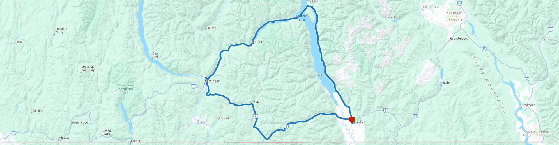
Roundtrip Highway BC3A Kootenay Mountain Creston Crawford Castlegar

This route was brought to you by:
RouteXpert René Plücken (MRA Master)
Last edit: 12-02-2021
 Route Summary
 You can enjoy beautiful nature in both the east and the west. The panoramas are beautiful and seem endless.
The roads are excellent and well maintained. Usually 2 lanes and with the necessary curves. There are several options for motorcycle trips through Canada, individually or organized.
Be surprised by this beautiful country. Plan your trip well and take the climate into account.
 Share this route


Animation

Verdict


Duration
4h 46m

Mode of travel
Car or motorcycle

Distance
292.37 km

Countries

 RouteXpert Review
 Departure and start is in Creston, when you leave Creston the HW BC-3a already starts and you enter the Creston Valley, this area is managed by the Creston Valley Wildlife Management Area to prevent invasive species from settling in the wetlands, with especially on cattails or reed canary. At RP2 Duck Lake is on your left.
The BC-3a winds between the shores of Lake Kootenay and the mountains on your right. Between the trees you regularly have a beautiful view of the beautiful lake and the Kootenay mountains on the other side. Along the route there are several options to stop for a photo, such as at RP4, near Columbia Point.
From RP4 you continue with the Lockhart Creek Provincial Park on your right, the park has small beaches on Kootenay Lake and there are a number of small campsites if you want to plan a longer stay. In the park you can walk, fish (in season) and hunt (in season). Along BC-3a there are a number of possibilities to stop for a drink, these are indicated with a route point and POI.
At RP8 we take the ferry to Balfour, this crossing takes about 35 min and is free. The Kootenay Lake Ferry is the longest free ferry trip in the world and worth the trip for the view alone. You have a beautiful view of the lake and the mountains around it.
After the crossing you can choose to eat something in Balfour. There are a number of small restaurants and snack bars.
At RP9 you can take a break at the Kokanee Creek Provincial Park and Beach. The park has 3 beautiful white beaches and forests with lots of privacy. The area is absolutely beautiful.
We continue on the BC-3a along the banks of the Kootenay River towards Nelsen. At RP10 we come to the Nelson Bridge, which is also known as the Big Orange Bridge or BOB. This is the only bridge at Nelson over the Kootenay River. It is definitely worth stopping across the street to take a nice photo from the beach. For this you have to turn right twice at RP11 and drive back to the beach. There is also a café at the beach for a drink.
We continue the drive along the river and now arrive in an area where there are a number of dams, these are often beautiful and very impressive buildings, so ideal to stop for a photo. The first dam is the Corra Linn Dam (RP12) and was originally built in 1932 to control the upstream storage in Lake Kootenay and generate power through three 19,000 hp turbines. The dam is 16 meters high and the capacity is 51 MW.
The next dam is the Brilliant Dam (RP13), a hydroelectric dam near Castlegar, built during World War II, it is 42.6 meters high and has eight sluice gates.
The next point where we will stop for a photo is RP14, here you can walk over The Brilliant Suspension Bridge, this is a suspension bridge over the Kootenay River near Castlegar. It was built in 1913 by Doukhobors settled in the area to replace a ferry across the river. In 1966, the new Highway 3A bridge replaced it and was abandoned. Restoration started in the early 1990s and the bridge was declared a National Historic Site in 1995. In 2010 the bridge was reopened as a footbridge.
When we have boarded again we drive at RP15 over the new bridge and here you also have a nice view of the old Briljant Suspension Bridge.
Near the airport there are two sights that are definitely worth a little longer stop. At RP16 you can visit the Doukhobor Discovery Center. Here you can relive life in the southern interior of British Columbia (1908-1938). Enjoy indoor and outdoor displays, interactive educational exhibits and historical artifacts. Take a tour with friendly knowledgeable staff.
Within walking distance of the Discovery center is The Kootenay Gallery of Art, History and Science (RP17). This is a public art gallery serving the entire West Kootenay region with a variety of exhibitions and public performances for all ages. It is one of the 28 original exhibition centers built in the 1970s so that rural residents could enjoy the great works of art, regionally, nationally and internationally, as well as provide a professional venue for regional artists to display and sell their work.
After this stop, the return trip to Creston is still about 120 kilometers. This ride is enjoyable, you wind over BC-3a through a beautiful nature reserve, along the way there are several points to stop for a photo. The only option for a short stop to have a drink or refuel is in Salmo (RP19), a small village on the river Salmo with about 1140 inhabitants. The village of Salmo was featured in the historical documentary series Gold Trails and Ghost Towns (season 3, episode 1).
Via the Kootenay pass we drive to the end point in Creston.
I rate this route with 5 ***** Stars because of the beautiful roads, beautiful nature, beautiful panoramas, beautiful ferry crossing, sights and nature parks along the route.


 Links
Links  Usage
Usage Want to download this route?
You can download the route for free without MyRoute-app account. To do so, open the route and click 'save as'. Want to edit this route?
No problem, start by opening the route. Follow the tutorial and create your personal MyRoute-app account. After registration, your trial starts automatically.  Disclaimer
Use of this GPS route is at your own expense and risk. The route has been carefully composed and checked by a MyRoute-app accredited RouteXpert for use on TomTom, Garmin and MyRoute-app Navigation.
Changes may nevertheless have occurred due to changed circumstances, road diversions or seasonal closures. We therefore recommend checking each route before use.
Preferably use the route track in your navigation system. More information about the use of MyRoute-app can be found on the website under 'Community' or 'Academy'.

British Columbia
About this region
British Columbia (BC) is the westernmost province of Canada, situated between the Pacific Ocean and the Rocky Mountains. With an estimated population of 5.2 million as of 2021, it is Canada's third-most populous province. The capital of British Columbia is Victoria, the fifteenth-largest metropolitan region in Canada, named for Queen Victoria, who reigned over the British Empire at the time of Confederation. The largest city is Vancouver, the third-largest metropolitan area in Canada, the largest in Western Canada, and the second-largest in the Pacific Northwest. In October 2013, Greater Vancouver had an estimated population of approximately 2.5 million. Since 2017, the province has been governed by the New Democratic Party, led by John Horgan, first with a minority government elected in 2017 and subsequently with a majority government elected in 2020.
Read more on Wikipedia
View region
 Statistics
  15
15Amount of RX reviews (British Columbia)
 12292
12292Amount of visitors (British Columbia)
 558
558Amount of downloads (British Columbia)
 Route Collections in this region
 Top car and motorcycle tour through Canada USA and the Rockies
Traveling by car or motorcycle through Canada, USA and the Rockies is a journey that you don't just make, so don't drive for 15 days and then return home. No, book a stay of several days in Vancouver, Jasper, Banff, Seattle and Port Alberni and again Vancouver to also visit several places of interest in these cities, so that this tour becomes an unforgettable tour that you can remember with pleasure.
Do not forget to arrange and pack the following items:
*This is only a summary and completely personal and may differ per person.
Take out travel insurance, +31 for numbers in GSM, (partially) take out gas, Health insurance coverage at destination?, Switch off electrical appliances, Lighting (time clock), Check passport validity, Antenna from radio/TV due to lightning, Residence address for those left behind, Remote control house alarm, Book Smart Parking.
Hand luggage:
Liquids in packaging of max. 100 ml, Liquids in hand luggage in transparent plastic bag.
For on the road:
Candy, Book, Earplugs, Country and road map(s), Directions, Maps in your navigation system
Money & Securities:
Bank card / giro card, Credit card (think pin code), Cash, Calculator for Internet banking, Medical insurance card, Travel insurance card.
Travel documents:
Passport, (International) Driver's License, Ticket(s), Reservation Tickets, Hotel Vouchers, Arrival/Departure Time, Check-in & Check-out Times, Valid Visa (ESTA), Travel Guide.
Clothing:
Underwear, Belt, Shirts/ T-shirts, Shorts, Long pants, Shoes, Socks, Swim trunks, Towel, Slippers.
Personal stuff:
Watch, House Keys, Wallet, Sunglasses.
Toiletries:
Deodorant, Shower gel / Soap, Comb / brush, Shaving equipment, Shampoo, Toothbrush, Toothpaste, Sanitary pads
Health & Medicine:
Own medicines, Insect repellent, Cold sore ointment, Ointment for insect bites, Sunscreen, Norit, Paracetamol, Suction cup for insect bites, First aid bag.
Miscellaneous:
Travel bag / waist bag, Leatherman (= checked luggage), Pen or pencil, Headlamp, Lighter, Tools & Electronics, Mobile phone & charger, Photo/video camera & charger, Memory card(s), World plug / adapter, Ipod & charger, Adapter cable Ipod, Headphones, iPad & charger, Navigation & charger/plug, Plug socket, Fuelpack battery.
Engine (accessories):
Helmet, Motorcycle clothing, Motorcycle boots, Chain lock / disc brake lock, Gloves, Bandana, Inner bags (plastic shopping bag), Insulation bag, Tension straps, Tie wraps, Rain suit, Rainaway.
Addresses:
Address list, Embassy telephone number, Telephone number to block (bank) card(s), Telephone number (airline tickets).
View Route Collection
Trans Canada Highway
The Trans-Canada Highway (TCH) or Trans-Canadian Highway is a system of highways that cover all 10 provinces of Canada.
The Federal and Provincial Highways System that now forms the TCH were authorized by the Trans-Canada Highway Act of 1948 and opened in 1962. It was completed in 1971. The total length of the TCH is 7821 km.
Contrary to the American Interstate Highway System, the TCH does not consist of an unambiguous network of motorways, but forms a network of restricted access highways and other main routes that are more akin to the Dutch provincial roads. The route is indicated by a green shield with a white maple leaf.
The numbering of the roads that are part of the TCH is the domain of the provinces. Only the western provinces have aligned their numbering and the TCH has the designation Highway 1 there.
The main route of the TCH starts in Victoria in British Columbia and runs via Calgary and Regina to Winnipeg. From Winnipeg the route leads to Kenora in Ontario, after which several branches pass through Ontario to Ottawa.
Further east, the route passes through the province of Quebec via Montreal and Quebec, among others, to Moncton, New Brunswick. Then the TCH continues east through Nova Scotia, where a branch (via the Confederation Bridge) leads to Prince Edward Island. Another section runs down to the sea in the port city of Sydney, where a ferry service leaves for Channel-Port aux Basques on the island of Newfoundland. From there the route continues for more than 900 km to the provincial capital of St. John's, in the extreme southeast of the island.
We not only drive the TCH, but will take the rural roads as much as possible, because only Highway driving is too boring and Canada has many beautiful roads through its beautiful landscape. You drive through all provinces and through very varied and scenic landscapes, from the Rockies in the West, the Central Prairies to the Eastern Maritimes and the Northern Forest.
The riding season is generally April through October with longer seasons on the west coast and southern Ontario. Provide good all season clothing or bring rain gear, depending on the province and the season the weather can change and you may be surprised by a rain or even a snow or hail shower, so be prepared.
In Canada the metric system is used, so speeds are indicated in Km / h. A helmet requirement (DOT approved) applies throughout Canada.
You will see many wildlife throughout Canada. This varies from province to province, such as deer, buffalos, moose, caribou, wolves, pumas, bears, mountain goats, sheep, lynx, coyotes, foxes, raccoons, badgers, various rodents and all kinds of birds. Even if it is very tempting to stop for a photo, don't do it, it can be very dangerous.
The routes described in this review sometimes deviate from the Trans Canada Highway, bringing the total length to 9,300 kilometers. The routes are made so that you drive through the beautiful parts of Canada with truly beautiful panoramas and beautiful sights to visit, this differs from museums, parks to historical points. The routes are not too long so there is time to stop for photos and sights along the way. You can also choose to arrange and combine the stages differently or to add other routes to shorten or extend your journey. The routes are marked with a rating in stars, some routes are less challenging or interesting but are necessary to drive to the next point, which is why they often have a lower rating.
In the route description you will find more details about the routes and the points of interest along the way. These points and also hotels, restaurants, petrol stations etc. are indicated with a POI and sometimes also with a Route point. In the description you will also find links to interesting sites and to the routes that connect to that day.
The described routes are;
Day 01 TCH Victory to Nanaimo
Day 02 TCH Nanaimo to Hope
Day 03 TCH Hope to Kamloops
Day 04 TCH Kamloops to Revelstoke
Day 05 TCH Revelstoke to Lake Louise
Day 06 TCH Lake Louise to Calgary
Day 07 TCH Calgary to Medicine Hat
Day 08 TCH Medicine Hat to Moose Jaw
Day 09 TCH Moose Jaw to Regina
Day 10 TCH Regina to Brandon
Day 11 TCH Brandon to Winnipeg
Day 12 TCH Winnipeg to Kenora
Day 13 TCH Kenora to Ignace
Day 14 TCH Ignace to Thunder Bay
Day 15 TCH Thunder Bay to Marathon
Day 16 Thunder Bay to Wawa
Day 17 TCH Wawa to Sault Ste Marie
Day 18 TCH Sault Ste Marie to Espanola
Day 19 TCH Espanola to Mattawa
Day 20 TCH Mattawa to Ottawa
Day 21 TCH Ottawa to Montreal
Day 22 TCH Montreal to Quebec
Day 23 TCH Quebec to Riviere du Loup
Day 24 TCH Riviere du Loup to Grand Falls
Day 25 TCH Grand Falls to Fredericton
Day 26 TCH Fredericton to Moncton
Day 27 TCH Moncton to Charlottetown
Day 28 TCH Charlottetown to Truro
Day 29 TCH Truro to North Sydney
Day 30 TCH North Sydney to Corner Brook
Day 31 TCH Corner Brook to Grand Falls
Day 32 TCH Grand Falls to Clarenville
Day 33 TCH Clarenville to St John.
Have fun reading the reviews and planning your next road trip.
If you have driven this trip, I am very curious about your feedback!
View Route Collection