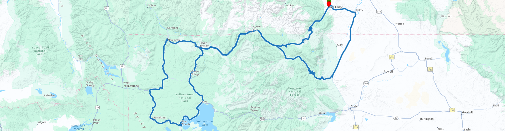
Red Lodge to Old Faithfull Two Day Round trip Beartooth Highway and Yellowstone Park

This route was brought to you by:
RouteXpert René Plücken (MRA Master)
Last edit: 12-02-2021
 Route Summary
  Share this route


Animation

Verdict


Duration
9h 41m

Mode of travel
Car or motorcycle

Distance
540.22 km

Countries

 RouteXpert Review
 It traces a series of steep zigzags and switchbacks, along the Montana-Wyoming border to the 10,947 ft (3,337 m) high Beartooth Pass. The approximate elevation rise is from 5,200 ft (1,600 m) to 8,000 ft (2,400 m) in 12 mi (19 km) in the most daring landscapes.
When driving east to west the highest parts of the Beartooth Highway level off into a wide plateau near the top of the pass, then descend to the junction with Wyoming Highway 296 (Chief Joseph Scenic Byway) near Cooke City, the northeast gateway to Yellowstone National Park. On the way one passes numerous lakes typical of the Absaroka-Beartooth Wilderness Area which borders the highway along much of its route. Take your time to enjoy the ride and stop to at overlooks or parking’s to admire the scenery and take picture. There are a couple of camp sites near the lakes where you can take beautiful pictures.
In Cooke City (RP10) you can plan your lunch and fill up with gas.
Official end of the Beartooth Highway and start of Yellowstone Park is at RP11.
We enter Yellowstone park and ride the beautiful scenic road, at RP12 you can briefly stop to admire the view over Yellowstone River and take a picture.
At RP13 you can park to admire the Mammoth Hot Springs and walk the 3,5 miles trail on boardwalks that also features a waterfall.
At RP14 you can take a right in 100 yards to admire and take pictures of the Terrace Springs, A short trail on boardwalks along some beautiful springs.
At RP18 you can stop to and walk the Fountain Paint Pot Trail where you will see various hydrothermal features that are expressions of Yellowstone’s still active volcano. Within this geologic system, each type of thermal feature is represented. They can be grouped into two general categories—those with a great deal of water (hot springs and geysers) and those with limited water (mudpots and fumaroles). Despite their structural similarities, no two features are exactly alike.
RP19 Bisquit Basin Trail is a beautiful scenic trail that loops through a number of geothermal features on a developed boardwalk.
You’ll stay overnight at the Old Faithfull Inn (RP20); one of the most popular lodging facilities at Yellowstone National Park. Ideally located within view of the world-famous Old Faithful Geyser, this lodge offers many highlights and advantages you won't find anywhere else. The inn has more than 300 rooms available, including newly renovated suites and premium rooms that combine old-fashioned and modern characteristics indicative of Yellowstone's history.
Some worthwhile RPs to stop and take picture of the amazing scenery and waterfalls are;
RP21 Kepler Cascades Waterfall
RP22 West Thumb Geyser Basin and Yellowstone Lake
RP23 to visit The Fishing Bridge Visitor Center and Museum, a wonderful place to make a pit stop when you're out and about in the Lake Area. Inside this old log building you will discover the wide variety of wildlife that lives in and around the largest lake above 7,000 feet in North America. There are several animal displays in the Visitor Center, including: grizzly bears, bald eagle, trumpeter swan and many more
RP24 Le Hardy's Rapids Is part of the Yellowstone River where the river bed drops a little bit, throwing the water against large rocks creating turbulent wild water.
RP27 The Brink of Lower Falls and Lower Lookout Point are incredible places to take in the views of the mighty Lower Falls of the Yellowstone River in Yellowstone. Be careful the road up to the parking is unpaved.
In Canyon Village (RP29) you can stop for lunch and fill up with gas.
RP31 the Tower Falls
You finished the Yellowstone grand loop and will ride back to Red Lodge via the Bear-tooth Highway. Enjoy the ride back it will give you another perspective of the beautiful scenery.
I rate this ride with 5 stars, because of the beautiful twisty roads and scenery.


 Links
Links  Usage
Usage Want to download this route?
You can download the route for free without MyRoute-app account. To do so, open the route and click 'save as'. Want to edit this route?
No problem, start by opening the route. Follow the tutorial and create your personal MyRoute-app account. After registration, your trial starts automatically.  Disclaimer
Use of this GPS route is at your own expense and risk. The route has been carefully composed and checked by a MyRoute-app accredited RouteXpert for use on TomTom, Garmin and MyRoute-app Navigation.
Changes may nevertheless have occurred due to changed circumstances, road diversions or seasonal closures. We therefore recommend checking each route before use.
Preferably use the route track in your navigation system. More information about the use of MyRoute-app can be found on the website under 'Community' or 'Academy'.