Roundtour Le Doubs part 1

This route was brought to you by:
RouteXpert Peter Moerman - RouteXpert
Last edit: 25-02-2021
 Route Summary
 The Doubs department is relatively unknown but has a lot to offer. Not only nature and the nice roads, but also the city of Besançon has a lot to offer.
The routes start and end in Malbuisson where there are several hotels. If you are considering an extensive visit to Besançon, including the Citadelle, then I advise you to leave on time the second day. Then you will be in Besançon on time and you have plenty of time to get back to Malbuisson.
If you skip the Citadelle, the two routes can be driven in one long day.
I rate this route with 4 stars because of the varied roads, the beautiful nature and the culture to be admired.
 Share this route


Animation

Verdict


Duration
7h 4m

Mode of travel
Car or motorcycle

Distance
227.31 km

Countries


 RouteXpert Review
 The Doubs is a partial border river between France and Switzerland. Near Morteau, the Doubs forms the Lac de Chaillexon, after which the river plunges 25 m down into a waterfall, Le Saut du Doubs. Along the border with Switzerland, the Doubs makes its way through a narrow valley, the Gorges du Doubs. Slightly past Goumois, the Doubs makes a loop in Swiss territory.
Before the town of Montbéliard, near Valentigney, the Doubs nods to the southwest. Shortly after, at Voujeaucourt, the Doubs joins the Canal du Rhône au Rhin, which comes from the northeast of the Rhine. This part up to Dole, the Doubs flows through a valley. In some places there are waterfalls of about 1 m over the width of the Doubs. After Dole the area becomes flatter. At Besançon, the Doubs takes a long loop around the old city center.
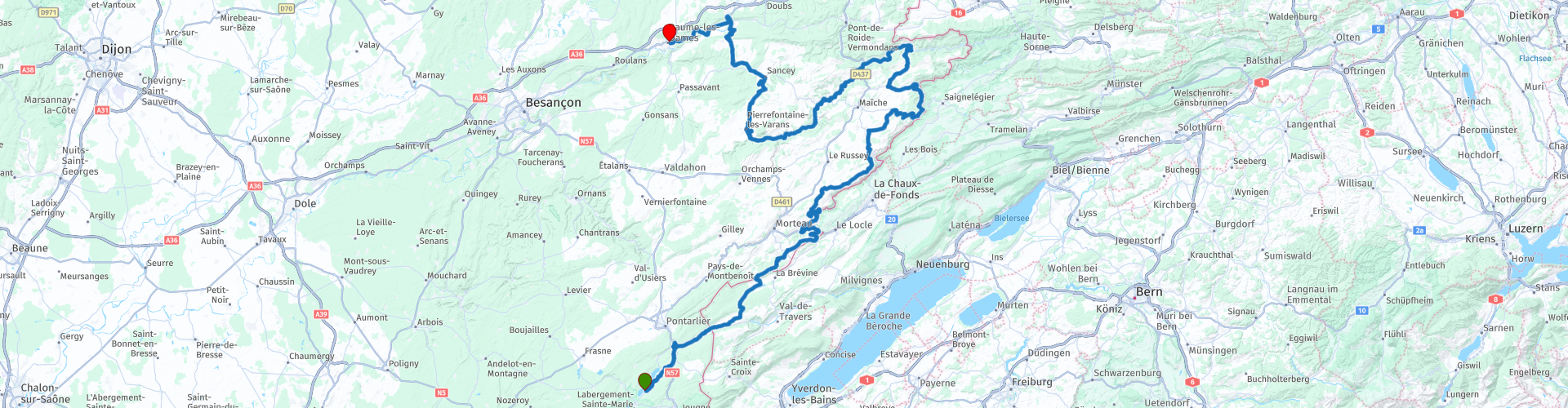
The route starts in Malbuisson at the Lac du Saint Point. This town has a number of hotels and is a great base for this route. Just outside the village you will pass La Source Bleue, a source worth checking out. The source can be reached from the parking lot within 10 minutes. Then it goes uphill towards Montperreux where just outside the village there is a viewpoint over the lake and the surrounding area. Near the village, the route leads to Chateaux de Joux, where there was a wooden fortification since the 11th century. In the 17th century, the old castle was transformed into a fortress with bastions and casemates. During the 19th century the castle served as a prison. After the Second World War, the castle lost its military function and became an open-air museum about the history of fortifications.
Just after the castle you pass the border with Switzerland, but after 15 km you drive out of Switzerland again and the route goes towards Villers le Lac. A few kilometers before this place you can visit Musée de la vie d'antan. A museum with old machinery from this region. The first refueling stop is planned in Villers le Lac, and you will pass the Doubs river for the first time. The route now follows the river, which also serves as a border between France and Switzerland here. At a number of points there are viewpoints for which you sometimes have to walk a few meters. The first coffee stop is planned at Saut du Doubs. You should definitely not miss this wonderfully narrow passage with waterfall. With a short walk you get to the viewpoints with a view of the waterfall. The route continues on beautiful winding roads to the northeast. Near Soulce Cernay you will pass a 15 meter high weir in the Doubs.
The lunch stop is planned in the town of Saint Hyppolyte. There are several terraces here on the water, so in good weather you can sit outside for lunch. After the lunch stop, the route heads southwest on lovely winding roads and then north to Clerval where you cross the Doubs again. You continue to follow the Doubs west to Baume les Dames, where the overnight stay and the second refueling stop are planned.
If you want to visit Besançon extensively and see the Citadelle, it is wise to leave on time on the second day, it is then only an hour to the Citadelle of Besançon and so you have plenty of time to expand this location with various museums. to watch. Places of interest in the city include this citadel, a World Heritage Site, and the cathedral. Other historic churches are the Église Saint-Maurice and the Église Sainte-Madeleine (in the Battant district, from the 18th century). In addition to the citadel, there are also fortifications in the historic city (Tour des Cordeliers, Tour de Chamars, Tour Notre-Dame and Tour Rivotte) and small fortresses around the city (Fort Griffon, Fort du Petit-Chaudanne, Fort de Chaudanne, Fort de Trois-Châtels, Fort Brégille and Fort Beauregard). The city also has several museums.
From Besançon the route continues along the Doubs and Loue a tributary. Another coffee or lunch stop is planned at Ornans. You can choose from various restaurants or terraces here. If you want to have your motorcycle in sight, choose La Table de Gustave, you can park opposite. At Pontarlier we pick up the Doubs again and the route goes towards Lac de Saint Point and the town of Malbuisson where the route ends.


 Links
Links  Usage
Usage Want to download this route?
You can download the route for free without MyRoute-app account. To do so, open the route and click 'save as'. Want to edit this route?
No problem, start by opening the route. Follow the tutorial and create your personal MyRoute-app account. After registration, your trial starts automatically.  Disclaimer
Use of this GPS route is at your own expense and risk. The route has been carefully composed and checked by a MyRoute-app accredited RouteXpert for use on TomTom, Garmin and MyRoute-app Navigation.
Changes may nevertheless have occurred due to changed circumstances, road diversions or seasonal closures. We therefore recommend checking each route before use.
Preferably use the route track in your navigation system. More information about the use of MyRoute-app can be found on the website under 'Community' or 'Academy'.

Neuchâtel
About this region
The Republic and Canton of Neuchâtel (French: République et Canton de Neuchâtel, pronounced [ʁepyblik e kɑ̃tɔ̃ də nøʃɑtɛl]) is a French-speaking canton in western Switzerland. In 2007, its population was 169,782, of whom 39,654 (or 23.4%) were foreigners. The capital is Neuchâtel.
Read more on Wikipedia
View region
 Statistics
  6
6Amount of RX reviews (Neuchâtel)
 12011
12011Amount of visitors (Neuchâtel)
 143
143Amount of downloads (Neuchâtel)
 Route Collections in this region
 From the Eifel via the Alps to the Dordogne in 5 great days
Literally from the start of the Eifel you go to Camping Moto van Hans in 5 crazy rides. You cross 3 countries (Germany, France and Switzerland) several times and the number of motorcycle areas is phenomenal. Eifel, Moselle, Hunsrück, Pfälzerwald, Vosges, Jura, Alps and then along France's most beautiful rivers, the Drome, Tarn, Lot and Dordogne. The number of bends is indescribable. Make sure your phone / camera has enough space, because you will rarely experience so much beauty in such a short time. Note: Driving in mountainous areas requires some experience, the journey as a whole is "spicy"
Day 1 starts in the Eifel and ends in the middle of the Vosges. With MRA it is possible to find the smallest and best roads, which are ideal for this type of route. In the evening of course eating Flammkuchen! However, this route and that of day 2 have to be careful when working on the road in France. Gravel is sprinkled on the road here and that is not always convenient for motorcyclists.
Day 2 goes partly through the Vosges, then the Jura and then you drive a long way through Switzerland. Watch out for your speed here, otherwise it could be very expensive. You don't drive through the highest part of Switzerland, but there is plenty to steer and plenty to see. Your hotel is in Martigny. You can eat in the center, which you reach after 5 minutes.
Day 3 just starts in Switzerland and soon you are on the Route des Grandes Alpes. You tackle a number of very high passes here, such as the Iseran and the Galibier. The height differences are enormous here, you drive here deep valleys and high peaks. Spending the night in Serre Chevalier (where you could theoretically have skied a few months earlier) is a very special experience.
Day 4 still has some big passes in store, after that the route runs via the Drome and the Tarn. The rivers have cut very deep gorges in the relatively soft chalk, resulting in steep mountain formations. A lust for the eye! The old monastery where the hotel is located is not only a feast for the eyes, but also a rich culinary experience.
Day 5 is the last day and takes you through the Cévennes National Park. Simply put, a very large forest, but there is more. The highest peak is 1,900 meters and the roads in the Cévennes are generally very narrow. This has the advantage that they are not used much. Ergo low-traffic and excellent quality. However, on these very narrow roads you have to watch out for the local population and "waste" from the trees. The first don't take it so well with the course of the road and you regularly see it right in front of you on your side of the road, the second occasionally causes broken branches on the road. There is a good chance that at the end you will find Hans with a big grin and a welcome beer waiting for you.
All in all a very impressive ride. All 1,824.75 kilometers (according to MRA) are delightful. The roads are good, the hotels were all excellent, there were certainly culinary delights and the undersigned was very lucky that there were hardly any clouds during all 5 days (August 2023). For the less experienced rider it is advisable to gain some knowledge in advance about riding in mountains and/or to take a rest day after the "queen stage" (day 3).
For those who are going to make the journey: lots of safe kilometers and lots of fun.
View Route Collection
Grand Tour of Switzerland
'The Grand Tour of Switzerland' leads past the most beautiful sights in the country.
Switzerland is a wonderful country to cross by motorcycle. Not only because of the beautiful roads, but also because of the cultural and other sights - and of course the beautiful mountains! The country has enormous diversity. Mountains and water in particular determine the landscape. Lake Constance in the north is one of the most popular holiday regions in Central Europe. With Lake Geneva in the far southwest, the Swiss (along with the French) also have one of the largest lakes on the continent. Don't forget Lake Maggiore in the south, although the red flag with the white cross only flies over a small part of it. There the influence of Italy becomes clear again. It is mainly based on language. This also applies to Lake Lugano, in the far south. This panoramic road, called the Grand Tour of Switzerland, is more than 1600 km long. Fans of mountain passes will be happy in many places. The route takes you to the Schwägalp, the San Bernardino and the Gotthard Pass. Divided into eight rides, it is a unique road trip.
Switzerland is a wonderful country to cross by motorcycle. Not only because of the beautiful roads, but also because of the cultural and other sights - and of course the beautiful mountains! The country has enormous diversity. Mountains and water in particular determine the landscape. Lake Constance in the north is one of the most popular holiday regions in Central Europe. With Lake Geneva in the far southwest, the Swiss (along with the French) also have one of the largest lakes on the continent. Don't forget Lake Maggiore in the south, although the red flag with the white cross only flies over a small part of it. There the influence of Italy becomes clear again. It is mainly based on language. This also applies to Lake Lugano, in the far south. This panoramic road, called the Grand Tour of Switzerland, is more than 1600 km long. Fans of mountain passes will be happy in many places. The route takes you to the Schwägalp, the San Bernardino and the Gotthard Pass. Divided into eight rides, it is a unique road trip.
View Route Collection