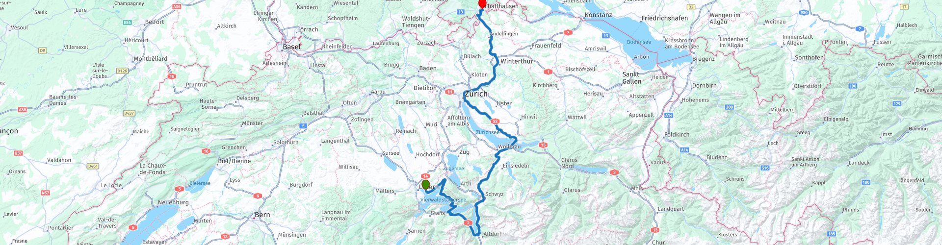
Grand Tour of Switzerland 08 Luzern to Schaffhausen along the Lakes Urn and Zurich

This route was brought to you by:
RouteXpert Catherine De Groote RouteXpert
Last edit: 18-02-2024
 Route Summary
 Switzerland is a wonderful country to cross by motorcycle. Not only because of the beautiful roads, but also because of the cultural and other sights - and of course the beautiful mountains! The country has enormous diversity. Mountains and water in particular determine the landscape. Lake Constance in the north is one of the most popular holiday regions in Central Europe. With Lake Geneva in the far southwest, the Swiss (along with the French) also have one of the largest lakes on the continent. Don't forget Lake Maggiore in the south, although the red flag with the white cross only flies over a small part of it. There the influence of Italy becomes clear again. It is mainly based on language. This also applies to Lake Lugano, in the far south. To discover all this, the Swiss tourist office has developed a special holiday route. This panoramic road, called Grand Tour of Switzerland, is 1643 km long. Fans of mountain passes will be happy in many places. The route takes you to the Schwägalp, the San Bernardino and the Gotthard Pass. You can follow the Grand Tour in either direction, but because most tourists do the journey clockwise, the official signposts have been adjusted accordingly.
Stage 8 of the Grand Tour of Switzerland goes from Lucerne to Schaffhausen. During the ride, a friendly mountain and hilly landscape determines the view, with glittering lakes in between. You will stay in the area of Lake Lucerne and Lake Urner See for a while. The views are sublime with beautiful mountains in the background. Some well-known cities such as Zurich and Winterthur are on the route, but Schwyz is also best known for the 'Swiss army knife'. A stop at Laufen Castle and the impressive Rhine Falls in Schaffhausen should certainly not be missed. Schaffhausen is also the end of this Grand Tour of Switzerland. As everywhere in Switzerland, the roads are of excellent quality. This route undoubtedly deserves 5 stars.
 Share this route


Animation

Verdict


Duration
8h 39m

Mode of travel
Car or motorcycle

Distance
188.59 km

Countries

 RouteXpert Review
 From Weggis you continue driving along Lake Lucerne to the car ferry in Gersau.
The car ferry across Lake Lucerne is the only one that is officially part of the Grand Tour of Switzerland. Since 2016, the ferry has had the first and only 'mobile' Grand Tour photo spot. The background scenes constantly change during the journey, offering endless variations for unforgettable souvenir photos.
There is a ferry from 7 am and it departs every hour on the hour. The crossing takes 20 minutes.
After the crossing, take the Seebergtunnel to Altdorf. The name of the tunnel does not come from the mountain of the same name, but from the famous village of Seelisberg. The mountain massif, which is mainly crossed by the Seelisberg tunnel, is the 1924 m high Niederbauenchulm. The tunnel was built between 1971 and 1980. When put into use, the 9,292 meter long tunnel was the longest two-tube tunnel intended for motor vehicles in the world. That record has now been passed to the Yamate Tunnel in Japan. The Seelisberg Tunnel is still the longest two-tube road tunnel in Switzerland.
You continue to follow the Urner See, which is part of Lake Lucerne.
At Tellsplatte is the spot where, according to legend, William Tell jumped overboard during a storm while being taken by boat to prison. Along an easy walk in beautiful scenery you will go to Tell's chapel, with the largest chimes in Switzerland (38 bells) nearby. The carillon can be operated by anyone free of charge during the day from 9:00 am for the first 10 minutes of every hour on the hour. Currently, 20 melodies (e.g. the overture to Rossini's William Tell, the Wedding March, folk songs from the four Swiss language regions) can be activated via a control panel.
As you continue your ride along Lake Urner, some beautiful views of the lake and the surrounding mountains await you. Here and there there is a parking lot where you can fully enjoy the view.
In Brunnen there is again a photo spot of the Grand Tour over Lake Lucerne. In the distance you can see an alpine meadow, the Rütli. According to legend, this is the historically important place where Switzerland was founded in 1291. Even further back you will see a pyramid-shaped mountain peak, the 2928 meter high Uirotstock. The village of Seelisberg is located on a sun terrace 850 m above sea level below the two mountains Niederbauen and Oberbauen.
The lively town of Schwyz, capital of the canton of the same name in Central Switzerland, is home to the 'Forum der Schweizer Geschichte' (national history museum) and important founding documents of the Swiss Confederation. Schwyz and its surroundings are known for the cherry blossoms and the numerous cherry specialties.
The Schwyzers have not always prospered economically. From the 16th century onwards, many had to serve in foreign military service. They proved to be brave warriors, often returned home as wealthy men and built impressive houses, which the town of Schwyz still bears witness to today.
The world-famous Swiss army knife is at home in Schwyz: more than 25,000 red all-rounders leave the factory here every day. So it is no wonder that a tourist destination around Schwyz now bears the name "Swiss Knife Valley".
Outside Schwyz you have a beautiful view of the Haggenspitz (1762 m) and Kleiner Mythen (1811 m). A little further, a sublime panorama of Lake Lauersersee and the surrounding mighty mountains awaits you.
The cozy and family-friendly restaurant Distel, in the middle of an enchanting landscape at an altitude of 950 m on the edge of the high moor near Rothenthurm, welcomes you for a delicious meal. The seasonal and classic Swiss home-style cuisine offers a wide range of menus freshly prepared every day.
The largest contiguous raised bog in Switzerland is a feast for the eyes with different colors every season. It is a protected habitat for plants and animals.
Peat used to be cut in the raised bog of Rothenthurm. The characteristic peat cutters and huts still bear witness to this once flourishing industry. The Rothenthurm raised bog was the first raised bog in Switzerland to be placed under protection after a referendum in 1987.
Although Rapperswil is located on the right bank of Lake Zurich, this city does not belong to the canton of Zurich, but to St. Gallen. Rapperswil Castle is the landmark of the picturesque 'Rose City', which lies on the shores of Lake Zurich. The castle, which was built towards the end of the 12th century and subsequently renovated several times, can be seen from afar. It towers high above the city, atop a long rocky hill called the Lindenhof.
Ignore the road along Lake Zürich on the left. You choose the quieter route through the interior with wide open views.
Zurich, the largest city in Switzerland, has been voted the most liveable city in the world several times. The city is located at the northern end of Lake Zurich and on the Limmat River. The old town impresses with historic buildings and picturesque streets.
The city on the water offers a combination of city life and nature.
Winterthur is a treasure trove of art, history and nature. The pedestrian zone in the charming Old Town is considered the largest in Switzerland. The city owes its cultural wealth to wealthy patrons from the time when Winterthur was an important industrial center: with the emerging industrialization in the 19th century, Winterthur experienced a rapid rise into an important economic center thanks to engine, locomotive and textile factories. In addition to numerous stages, the cultural city also has the largest "Gastspielhaus" in Switzerland and houses the Swiss center for cabaret and comedy. Despite the tradition of industry, Winterthur is also a 'garden city' with a striking number of parks and gardens.
In Kleinandelfingen take the A4 motorway to Uhwiesen where you turn left to Schloss Laufen at the Rhine Falls.
With a width of 150 meters and a height of 23 meters, the Rheinfall is the largest waterfall in Switzerland and even in Europe. The largest waterfall because of its width! The Rheinfall was created in the last ice age and the largest measured water throughput is 600 cubic meters per second (in summer).
Schloss Laufen is located on a high rock wall, giving you a fantastic view of this impressive natural spectacle.
It is also worth taking a closer look at the castle itself and learning more about its thousand-year history in the 'Historama'. The ancient walls were first mentioned in writing in 858 and have experienced many turbulent events. The canton took over the complex and gradually restored it.
The castle was reopened in 2010. It is a modern tourist beacon in the Schaffhausen region.
You are now a stone's throw from Schaffhausen. There is a motorcycle parking area just over the bridge over the Rhine.
The imposing fortress 'Munot' sits enthroned above the medieval old town. The houses in this city center are richly decorated with bay windows and expensively painted facades.
The Munot Castle was created around 1580 as a defense structure based on designs by Albrecht Dürer about fortifying cities. During its history, the castle had to withstand a siege only once, in 1799, otherwise the residents of Schaffhausen enthusiastically used the complex peacefully. The tower houses the Munot keeper's home, who rings the famous Munot bell every evening at 9 p.m. for five minutes – of course by hand as in 1589.
From the battlements of Munot you get a fantastic view of the old town and the river landscape of the Rhine.
This is the final end of the Grand Tour Switzerland. For eight days you were able to taste a variety of landscapes and culture. Time to look back on the past days... What better way to do this than on the terrace of one of the many cozy cafés in the city center with a drink or a regional or gastronomic delicacy...


 Links
Links  Usage
Usage Want to download this route?
You can download the route for free without MyRoute-app account. To do so, open the route and click 'save as'. Want to edit this route?
No problem, start by opening the route. Follow the tutorial and create your personal MyRoute-app account. After registration, your trial starts automatically.  Disclaimer
Use of this GPS route is at your own expense and risk. The route has been carefully composed and checked by a MyRoute-app accredited RouteXpert for use on TomTom, Garmin and MyRoute-app Navigation.
Changes may nevertheless have occurred due to changed circumstances, road diversions or seasonal closures. We therefore recommend checking each route before use.
Preferably use the route track in your navigation system. More information about the use of MyRoute-app can be found on the website under 'Community' or 'Academy'.

Nidwalden
About this region
Nidwalden, also Nidwald (German: (Kanton) Nidwalden, [ˈnidˌvaldən] (listen)) is one of the 26 cantons forming the Swiss Confederation. It is composed of eleven municipalities and the seat of the government and parliament is in Stans. It is traditionally considered a "half-canton", the other half being Obwalden.
Nidwalden lies in Central Switzerland. It borders the canton of Obwalden to the west, the cantons of Lucerne and Schwyz to the north, the canton of Uri to the east and the canton of Bern to the south. The canton is essentially in the Alps, south of Lake Lucerne.
It is one of the smallest cantons, the population is 40,287 (in 2007). The largest town is Stans, followed by Hergiswil and Buochs.
Together with Obwalden, Nidwalden was part of the forest canton of Unterwalden, one of the three participants in the foundation of the Old Swiss Confederacy, named in the Pact of Brunnen of 1315 with Uri and Schwyz. The division of Unterwalden into two separate territories, Obwalden and Nidwalden, appears to develop over the course of the 14th and 15th centuries.
Read more on Wikipedia
Nidwalden lies in Central Switzerland. It borders the canton of Obwalden to the west, the cantons of Lucerne and Schwyz to the north, the canton of Uri to the east and the canton of Bern to the south. The canton is essentially in the Alps, south of Lake Lucerne.
It is one of the smallest cantons, the population is 40,287 (in 2007). The largest town is Stans, followed by Hergiswil and Buochs.
Together with Obwalden, Nidwalden was part of the forest canton of Unterwalden, one of the three participants in the foundation of the Old Swiss Confederacy, named in the Pact of Brunnen of 1315 with Uri and Schwyz. The division of Unterwalden into two separate territories, Obwalden and Nidwalden, appears to develop over the course of the 14th and 15th centuries.
View region
 Statistics
  5
5Amount of RX reviews (Nidwalden)
 12354
12354Amount of visitors (Nidwalden)
 558
558Amount of downloads (Nidwalden)
 Route Collections in this region
 The 24 Most Beautiful Alpine Routes
The Alps, The Alps are a mountain range in Europe, stretching from the French Mediterranean coast in the southwest to the Pannonian Plain in the east. The area of the mountain range is more than 200,000 km².
In other words Passes and Mountain Roads!
Driving through the mountains is great! Especially over the mountain passes with hairpin bends and narrow winding roads. Every bend a different view where you can enjoy. There are many beautiful mountain passes in the Alps.
A selection that has also been incorporated into these routes:
The Stlevio Pass:
The Stelvio Pass, also known as Passo dello Stelvio, is mainly known for the stage in the Giro d'Italia. Due to the length and the difference in height, this pass is seen as one of the toughest tests in cycling. The Stelvio Pass reaches a maximum height of 2758 meters and is therefore one of the highest in the Alps. The pass connects the towns of Bormio and Prato Allo Stelvio. In winter the pass is closed due to heavy snowfall.
The Reschenpass:
The Reschenpass, also known as Passo di Resia, connects the Austrian state of Tyrol with the Italian province of South Tyrol. The pass reaches a maximum height of 1,504 meters and has been one of the most important north-south connections in the Alps in recent centuries. The pass was used long before Roman times. Along the way you will pass several highlights and historical relics. One of the highlights is the Reschensee. This lake was created after the construction of the dam and has completely submerged the village of Graun. The only thing that reminds of that is the clock tower in the middle of the lake.
Col du Galibier:
The French mountain pass Col du Galibier connects the towns of Saint-Michel-de-Maurienne and Briançon via the Col du Lautaret in the south and the Col du Télégraphe in the north. The mountain pass is part of the Tour de France and very much feared, due to the fact that it can only be reached via the other two mountain passes. The pass reaches a maximum height of 2646 meters. From there you can take a walk to the viewpoint at 2704 meters. You can admire the peaks of the Grand Galibier, Mont Blanc and La Meije here.
The Grossglockner High Alpine Road:
With a height of 3798 meters the Grossglockner is the highest mountain in Austria. To fully enjoy this impressive mountain, you can drive over the Grossglockner High Alpine Road and the accompanying pass. The route starts from Bruck am Grossglockner and ends in Heiligenblut. Of course you can drive in two directions. The pass reaches a maximum height of 2504 meters and is closed in winter due to heavy snowfall. Along the way you pass several stops with fun activities, information points, mountain huts and viewpoints. A visit to the Kaiser-Franz-Josefs-Höhe and Pasterzen Glacier is highly recommended.
The Col d'Izoard:
Just like the Col du Galibier, the Col d'Izoard is also part of a stage of the Tour de France. The mountain pass connects Briançon with the valley of the river Guil. The pass is partly located in the Regional Natural Park du Queyras and reaches a maximum height of 2360 meters. What is special about the Col d'Izoard is the barren and rocky landscape. Sometimes it feels like driving a car over the moon! Along the way you can stop at several points to enjoy the beautiful view.
The Bernina Pass:
The Bernina Express is one of the most famous rail trains in Switzerland and the Alps. The route is beautiful and partly included on the UNESCO World Heritage List. Parallel to the railway lies the Bernina pass, which connects the Veltlin valley with the Egandin valley. This beautiful Alpine road has a total length of 56 kilometers and reaches a maximum height of 2328 meters. Along the way you can enjoy views of the Morteratsch Glacier.
The Sella Pass:
The Sella Pass, also known as Passo di Sella, takes you over one of the most impressive mountain ranges in the Dolomites: the Sella massif. The pass connects Valle di Fassa with Val Gardena and reaches a maximum height of 2236 meters. At this height is also the border of the Italian provinces of Trentino and Bolzano. Along the way you can enjoy the view of this spectacular mountain world. Admire, for example, the three peaks of the Sasso Lungo massif, the Sella massif or the peaks of the Marmolada. You can also drive the Sella pass in combination with the Gardena pass, Pordoi pass and Campolongo pass.
The Grimsel Pass:
The Grimsel Pass connects Goms in Wallis with the Halis Valley in the Bernese Oberland. The pass reaches a maximum elevation of 2165 meters and is closed in winter due to snowfall. Over the centuries, the mountain pass has played an important role in trade between Switzerland and Italy. Now it is mainly the reservoirs that have an important function. These are used to generate electricity. The landscape you drive through is rugged, rocky and impressive. On top of the pass is a hotel and a restaurant with a special marmot park. The Dodensee (Totensee) is also located here. This lake owes its name to the many soldiers who died in the time of Napoleon.
The Gotthard Pass:
The Gotthard Pass, also known as Passo del San Gottardo and Saint Gotthard, connects the Swiss towns of Airolo and Andermatt. The mountain pass and associated tunnel are especially known among holidaymakers driving from Switzerland to Italy. But where the majority opt for the tunnel, it is precisely the pass that really completes the holiday. The Gotthard Pass has a length of about 26 kilometers and reaches a maximum height of 2106 meters. The route is beautiful and takes you along old villages and beautiful views.
The Silvretta High Alpine Road and Silvretta Pass:
The Paznaun Valley in Tyrol and the Montafon in Vorarlberg are connected by the Silvretta High Alpine Road. The route has a length of 22.3 kilometers and leads from Galtür to Partenen in 34 hairpin bends, via the 2032 meter high Bielerhöhe. The Silvrettasee is also located at this point, where you can enjoy a lovely walk. The pass is closed in winter due to snowfall.
The Simplon Pass:
Just like the Gotthard Pass, many holidaymakers also travel over the Simplon Pass every year. This mountain pass connects the Rhone Valley in the canton of Valais with the Valle d'Ossola in Piemonte. The pass is open all year round and reaches a maximum height of 2005 meters. Along the way you pass a number of buildings, including the well-known Simplon Hospiz from 1825. The hospiz is managed by the monks of St. Bernard. From the highest point on the pass, all kinds of hiking routes are possible and you will also come across a hotel where you can spend the night.
The Gerlos Pass:
The Gerlos Pass connects the Salzach Valley in the Salzburgerland with the Zillertal Valley in Tyrol. The pass is part of the Gerlos Alpenstraße and runs right through the Hohe Tauern National Park. Along the way you can enjoy beautiful views of the surroundings. The pass has a length of 12 kilometers and reaches a maximum height of 1531 meters. A ride over the Gerlos Pass can be ideally combined with a visit to the Krimmler Wasserfälle.
The Great St. Bernard Pass:
The Great St. Bernard Pass, better known as Col du Grand Saint Bernard, connects the Italian province of Valle d'Aosta with the Swiss canton of Valais. The pass is one of the highest in Switzerland and reaches a maximum height of 2469 meters. Like a number of other mountain passes in this list, the Great St. Bernard Pass has also been used as a connecting road for centuries. The pass is named after the St. Bernard dogs that used to help stranded travelers along with the monks. The pass is closed in winter.
The Timmelsjoch High Alpine Road:
The Timmelsjoch High Alpine Road connects the towns of Sölden in the Ötztal and Meran in South Tyrol. Tolls must be paid on the Hochgurgl - Moos route. Via a mountain road with about 60 hairpin bends you drive through a beautiful mountain world. With the Timmelsjoch Experience you can learn more about the history, the road and the environment via various stations. You can also visit the Top Mountain Crosspoint museum.
Col de l'Iseran:
With a maximum pass height of 2770 meters, the Col l'Iséran is one of the highest mountain passes in the Alps. The pass connects Bourg-Saint-Maurice with Bonneval-sur-Arc. Via a road full of hairpin bends you pass, among other things, Val-d'Isère and a side valley of the Maurienne that lies entirely in the National Park de la Vanoise. You can spot animals such as marmots and chamois and there is also a restaurant with a chapel on top of the pass.
The Gavia Pass:
The Gavia Pass (Italian Passo di Gavia) is a mountain pass in the Italian Alps, in the Lombardy region.
It is one of the highest pass roads in Europe. The road leads through the unspoilt Stelvio National Park. The road was built in the First World War to supply Italian soldiers who fought in the Italian-Austrian border area. The pass height is one of the most beautiful in the Alps. Here is the large Lago Bianco with, to the north, the mountain San Matteo (3684 meters). Lago Nero is slightly lower on the south side of the pass. Here the mountain group of the Adamello determines the view. There are many well-marked walks in the area. During the winter the pass is closed due to the heavy snowfall. The pass is often closed until May and June due to the large amount of snow.
Promoter has made a selection of the 24 Most Beautiful Alpine routes that they have set out in recent years.
The routes go through:
France
Austria
Switzerland
Italy
The most beautiful roads, the most beautiful views, the most beautiful viewpoints. The highest mountains, the fastest descents, hairpin bend after hairpin bend, you name it you can't get enough of it.
If you go on holiday in this region, take advantage of it, ALL routes in this collection have been checked and made equal for TomTom, Garmin and MyRoute-app Navigation by a MyRoute-app RouteXpert.
Have fun with this collection and while driving one of these routes. Enjoy all the beauty that the Alps and the Dolomites have to offer. Click on “View route” to read the review of the chosen route.
I would like to hear your findings about the route(s).
View Route Collection
6 day tour CH IT AT DE over the most famous and also dreamy small passes and elevated roads
The six-day route leads over many of the most beautiful alpine crossings in Switzerland, Austria, Italy and Germany.
The path leads over well-known passes such as the Susten, Albula, Timmelsjoch, the Sellaronda, Drei Zinnen and the Ploecken as well as over the high roads of the Grossglockner and the Zillertal Panorama Road and much more. Highlights are also the countless unknown, dreamy alpine crossings away from the big traffic.
Most Alpine passes are only passable in summer, so be sure to check before you set off whether the passes are open.
The long daily routes as well as several road sections demand a lot and are only suitable for experienced drivers.
View Route Collection