Roundtrip through historic Berlin

This route was brought to you by:
RouteXpert Catherine De Groote RouteXpert
Last edit: 11-03-2021
 Route Summary
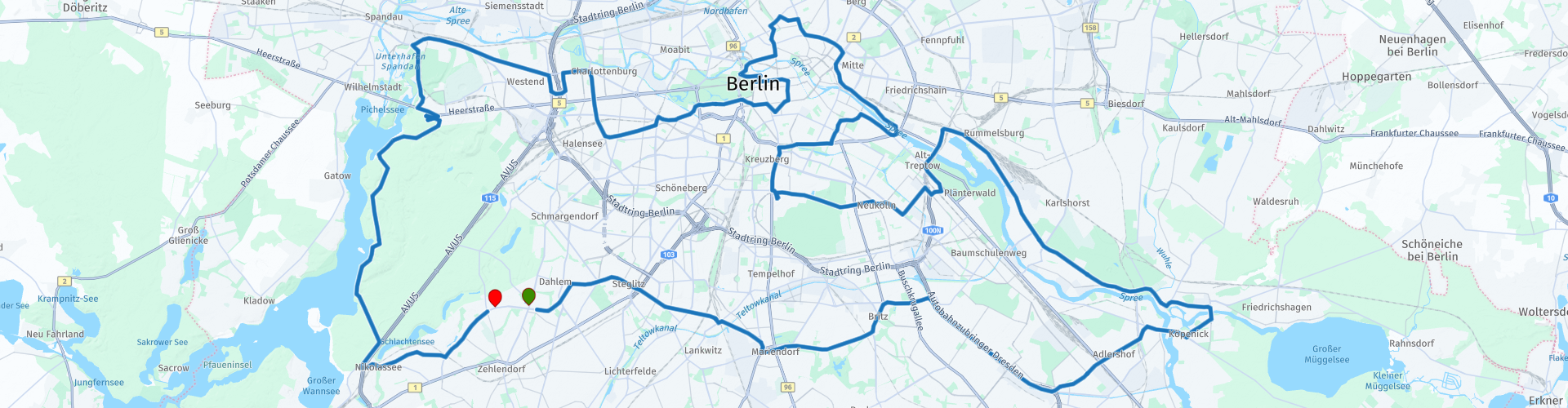
 This tour takes you through the heart of Berlin. The tour starts south along some beautiful parks and then continues through the center with its many sights and testimonies of the Cold War. You leave the city via Charlottenburg and the wooded Grunewald. The roads are - as in any big city - of course busy. But what you get to see fully compensates for this. The ride gets 4 stars.
 Share this route


Animation

Verdict


Duration
8h 41m

Mode of travel
Car or motorcycle

Distance
101.03 km

Countries

 RouteXpert Review
 In the south of Berlin you will cross the following districts: Steglitz-Zehlendorf, Tempelhof-Schöneberg, Neukölln and Treptow-Köpenick. There are many beautiful parks in this part of Berlin.
The Britzer Garten is a unique green oasis in the middle of the big city. It offers visitors ample space for recreation, leisure, sports, health and cultural activities. Hiking, discovering a colorful variety of plants and special horticultural shows, jogging, listening to live concerts in the open air or simply enjoying the fresh air in the countryside on the picnic blanket brought along: the Britzer Garten is a landscape full of possibilities in the urban space. In the center of the park is a lake of nearly 10 hectares, nestled between hills and meadows.
The 26-hectare Adlerhof nature park was proclaimed 'Landschaftspark ehemaliges Flugfeld Johannisthal' in 2003. The airport had been vacant since the late 1940s and nature has drained the area. It is surrounded by an elevated walkway so that it can be experienced without entering it. The landscaped park is designed in the style of classic English landscaping with open meadows and groups of oak and pine.
The Köpenick castle is located where the Dahme flows into the Spree. It is beautifully surrounded by water. Köpenick Castle is a unique witness from the time of the great Elector (1620–1688). It is the most important preserved castle built for the Hohenzollern Dynasty during his reign and which is part of the old town of Köpenick. Unchanged since then, the building in the Dutch Baroque style is also an example of the formative influence of the Netherlands at the end of the 17th century. Inside, valuable showpieces from the Hohenzollern treasure and an elaborately designed display of power are impressive.
Wuhlheide Park was created between 1919 and 1932. The various tree-rich areas and the garden-like aspects of the park were intended for those seeking tranquility. At the same time, areas for more active forms of recreation were also included. In addition to sports and playing fields, a dance floor, a toboggan run and a swimming pool were also constructed. The gradual reconstruction of the public park began in the late 1990s. The park is also placed on the list of historical monuments of Berlin. Also located here is a Berlin-Brandenburg model park where visitors have the chance to observe more than 60 models of famous landmarks from both Berlin and Brandenburg.
After the end of the Second World War, four Soviet memorials were built in Berlin to commemorate the fallen soldiers of the Red Army. The Soviet War Memorial in Treptower Park is the largest monument of its kind in Germany and the most important memorial to Soviet soldiers in Berlin. The monument was erected between 1946 and 1949. The construction required 40,000 cubic meters of granite. The monument is constructed symmetrically. A large triumphal arch marks the entrance. This is followed by the sculpture "Mutter Heimat" in the form of a female statue mourning her fallen sons. Visitors are then guided by two large stylized red granite flags. In the center of the monument is the statue of a Soviet soldier as high as a house, symbolizing the victory over the Nazi regime with a child in his arm and sword in hand. Visitors can descend via stairs to the cemeteries that have a symbolic character: the total of 7,000 dead buried on the site lie in rather inconspicuous graves at the edges of the complex.
The area of the former Berlin-Tempelhof Airport is located in the city center and extends over the Tempelhof district to Neukölln. With an area of 386 hectares, Tempelhofer Feld is the size of Central Park in New York, making it the largest green space in Berlin. Until a few years ago, it was one of the most important airports in the country. The series of buildings that used to house the terminals is now known as a landmark of engineering and, to some extent, also represents Berlin's past. In the meantime, you can also take a look inside Europe's largest architectural monument!
The Oberbaumbrücke over the Spree in Berlin connects the districts of Kreuzberg and Friedrichshain and consists of two levels, one for car traffic and pedestrians and one for the metro. During the division of the city, the Spree formed the sector boundary and there was a border crossing on the Oberbaumbrücke.
The most famous and longest section of the surviving Berlin Wall is the East Side Gallery section. At 1,316 meters, it is also the longest open-air gallery in the world. The part of the wall served as extra security as the Oberbaumbrücke was the border to the East. There is a huge amount of graffiti on display, but only on the west side. The GDR authorities did not allow the Wall to be 'daubed'. In the West this was a different case. The Wall here was already painted with graffiti during the division. After the fall of the wall, it was painted by 118 artists from December 1989. The artists came from 21 different countries. Most paintings deal with political affairs after the Wende and behind most paintings there is also a deeper meaning.
In addition to the Mercedes Center opposite the East Side Gallery, there are many restaurants where you can have lunch.
The Berlin Wall Memorial is the central memorial of the division of Germany. At its historic location on Bernauer Strasse, it stretches 1.4 km over the former border strip. The last part of the Berlin wall is located on the site of the monument, which has been preserved in depth and gives an impression of the construction of the border fortifications in the late 1980s.
The Reichsbahnbunker Friedrichstrasse was built to protect train passengers. It was designed to house 1,500 people. Planning work began in 1941 under the direction of Albert Speer as part of the 'Führer-Sofortprogramms' for the construction of air-raid shelters for the civilian population. After Germany surrendered in May 1945, Soviet forces took over the building to use it as a prison. After the end of the GDR in 1989/90 it was used for several short periods, including as a party location for the techno scene. In 2003 the bunker became an exhibition space for contemporary art. Due to its historical importance, the building has been listed as a monument.
The Reichstagsgebäude (or Reichstag for short, in Dutch: Reichstag) is one of Berlin's most famous landmarks. Since 1999, the German parliament, the Bundestag, has sat here, so that most Berliners are talking about the Bundestag and not the Reichstag. But they mean the same. The Reichstagsgebäude can be found on the Platz der Republik.
The building was opened in 1894. Almost forty years later (in 1933) the large conference room was destroyed by arson. The Dutchman Marinus van der Lubbe was arrested as a suspect and he has also confessed to the act. Many historians think that the Nazis also played a role in it because the attack served them well. The building had already been restored in the 1960s, but it was not thoroughly overhauled until after the reunification of Germany. An underground passageway was discovered between the Reichstag and the President's Palace. It is suspected that through this corridor Nazis could enter the building unseen to start the fire of 1933. The big draw is the new dome on the roof. From that dome you have a magnificent view over Berlin and you can see many of the famous sights.
The Monument to the Sinti and Roma of Europe is a reminder of the Porajmos, the National Socialist genocide of the Sinti and Roma. The monument was unveiled on October 24, 2012 in the presence of Chancellor Angela Merkel and Federal President Joachim Gauck.
Dani Karavan designed a circular water basin (source) with a black - endlessly deep - bottom. He placed a triangular stone in the center of the well, which recalls the triangle on the clothing of the concentration camp inmates. There is always a fresh flower on the stone. Whenever it has withered, the stone sinks into the well, to emerge again with a new flower: at the same time a symbol of life, mourning and memory. According to Karavan, the symbol of the source also reflects that those involved in the memory of the National Socialist crimes should not allow the struggle but reflection to dominate.
The Brandenburg Gate is Berlin's most famous landmark. It is a landmark and symbol in one with more than two hundred years of history. A former symbol of the divided city, it attracted visitors who used to climb an observation platform to glimpse the world behind the Iron Curtain, on the other side of the bare 'death strip' that stretches East from West Berlin. divorced, geographically and politically.
When Germany was reunited after the fall of the Berlin Wall in November 1989, the Brandenburg Gate quickly reinvented itself as the symbol of the unity of the new Berlin. It was officially opened to traffic on December 22, 1989, and 100,000 people came to celebrate the occasion.
The Bebelplatz is a square on the wide boulevard Unter den Linden, near the Staatsoper, in the Mitte district. The square is named after August Bebel (1840–1913), one of the founders of social democracy in Germany in the nineteenth century.
The Bebelplatz was to become the main square of the Forum Fridericianum and to reflect the greatness of ancient Rome. The square is mainly known for the book burning on May 10, 1933 by the Nazis. Some 25,000 books, including books by Heinrich Heine, Karl Marx, Thomas Mann and Erich Maria Remarque, were burned on the then Kaiser-Franz-Joseph-Platz because they were considered reprehensible. Nowadays there is a parking garage under the square, in which a monument in memory of that event is included (can be seen in the square from above).
The Gendarmenmarkt is one of the most famous squares in Berlin, also located in the Mitte district. It is characterized by two identical looking churches on either side of the square. The Französischer Dom (on the right side of the concert hall) was built between 1701 and 1705 for the Huguenots who had fled France. The Deutscher Dom was built in 1708 for the Protestants. The square is named after the Regiment Gens d'Armes that had its barracks here. From 1950 the square was called Platz der Akademie, but after the reunification of Berlin it got back its original name. In front of the entrance of the concert hall is a monument to the poet Friedrich Schiller.
The Berlin Wall had seven official border crossings. By far the best known is Checkpoint Charlie. This checkpoint was located on Friedrichstraße. A white line on the road surface indicated exactly where the Russian border ended and the American sector began. Checkpoint Charlie was the only place in Berlin where foreigners could enter East Berlin by road. The checkpoint was established on September 22, 1961. A large sign was placed at the border, with the text: “You are leaving the American sector”. The checkpoint became one of the symbols of the Cold War and the German division.
Potsdamer Platz is a busy traffic junction. That was the case in old Berlin before World War II, and it is now. After the reunification of the two Germanys, a large entertainment and shopping center was created around Potsdamer Platz in buildings of daring architecture. It is the new, beating heart of Berlin.
During the Cold War, Potsdamer Platz was a desolate square, the Berlin Wall ran right across it. One of the eye-catchers is the Sony Center, so named because the Japanese electronics manufacturer has its European headquarters there. The 103 meter high Kohlhoff Tower has a beautiful panoramic deck. You get there with the fastest lift in Europe. The former course of the Berlin Wall is marked in some places with stones in the road surface.
The Evangelical Kaiser-Wilhelm-Gedächtniskirche, which is actually always called the Gedächtniskirche popularly, consists of several buildings and is a protected monument. You can visit the Gedächtniskirche every day from 9:00 AM to 7:00 PM.
During the Second World War, the church suffered very hard. Much was destroyed and only a small shadow remained of what the beautiful church once was. The remaining 68 meter tower was soon nicknamed 'hollow molars' after the war. About half of the nave had been swept away, the remainder now more like a cave than a church.
The Kurfürstendamm (Keurvorstendam) is the largest shopping boulevard in Berlin. The street has a wide layout with separate lanes and a green strip in the middle (former tram track).
The baroque Schloss Charlottenburg is beautiful, but especially the extensive gardens that lie behind the chic palace. The Schloßpark is a very varied park with beautifully landscaped flowerbeds as well as wildly rampant lawns. The park can be visited publicly and is free of charge. Among all the greenery, next to the palace, you will also find the mausoleum with tombs of members of the Royal Hohenzollern family and the Belvedere, which was used as a holiday home and tea house. Charlottenburg Castle is named after the first Queen of Prussia, Sophie Charlotte, who had it built at the end of the 17th century. The wings were only added later. The palace was badly damaged in the Second World War, but it has now been completely renovated. Large parts are open to the public and the palace houses a large collection of porcelain, a beautiful ballroom, gaudy chandeliers and everything you imagine in a Prussian palace.
Shortly after the hostilities had ceased, graves were brought from the Berlin area and from East Germany to the Berlin War Cemetery 1939-1945. The vast majority of those buried here, about 80 percent of the total, were pilots who died in the air raids over Berlin and the cities of East Germany. The rest were men who died as prisoners of war, some of them during the forced march to Germany from camps in Poland, for the advancing Russians. The cemetery contains 3,595 Commonwealth war graves from World War II, 397 of which are unidentified. There are also 6 non-Commonwealth Foreign National graves as well as 265 post-war graves of men of the British occupation force or their families, or members of the Control Commission.
The cemetery of the Jewish community on Heerstraße is located in a forest of 3.4 hectares on Scholzplatz. The cemetery, geometrically laid out in 1955, contains more than 5,000 burial places. On the boulevard are some medieval tombstones from the so-called Juden-Kiewer, the Jewish cemetery in Spandau, which were found during excavations. A memorial to the Jewish victims of the Nazi regime was built from stones from the destroyed synagogue on Fasanenstrasse.
The chic Grunewald includes a huge forest of the same name and a residential area with elegant villas and hotels. The Teufelsberg is an artificial mound of World War II rubble, topped with a Cold War wiretapping station that you can now take a guided tour. Lake Teufelssee and the interactive nature center Ökowerk are nearby. The Gleis 17 monument in Grunewald station is a memorial to the Jews who were deported from this station.
After crossing the Grunewald you will arrive at the end of your ride. There are not that many kilometers on the clock, but all the more impressions you have gained from the war and post-war period in and around Berlin.


 Links
Links  Usage
Usage Want to download this route?
You can download the route for free without MyRoute-app account. To do so, open the route and click 'save as'. Want to edit this route?
No problem, start by opening the route. Follow the tutorial and create your personal MyRoute-app account. After registration, your trial starts automatically.  Disclaimer
Use of this GPS route is at your own expense and risk. The route has been carefully composed and checked by a MyRoute-app accredited RouteXpert for use on TomTom, Garmin and MyRoute-app Navigation.
Changes may nevertheless have occurred due to changed circumstances, road diversions or seasonal closures. We therefore recommend checking each route before use.
Preferably use the route track in your navigation system. More information about the use of MyRoute-app can be found on the website under 'Community' or 'Academy'.