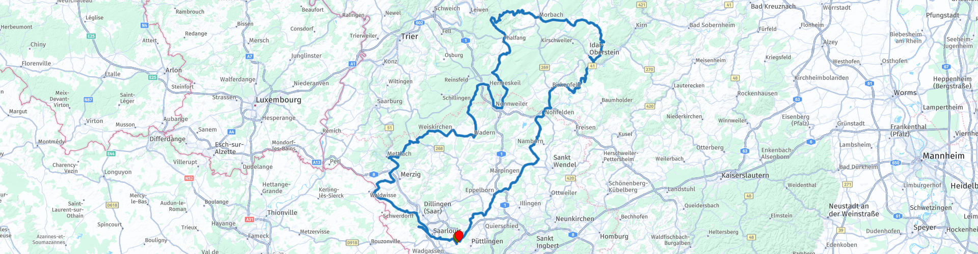
Roundtrip Saarlouis Idar Oberstein

This route was brought to you by:
RouteXpert Evert Kuiken
Last edit: 14-04-2021
 Route Summary
  Share this route


Animation

Verdict


Duration
5h 12m

Mode of travel
Car or motorcycle

Distance
273.39 km

Countries

 RouteXpert Review
 What can you see along this route:
RP 3 Saarlouis. This fortified city was founded in 1680 by King Louis XIV. There are still many remains of the fortress to be seen.
RP 5 Ruins of Siersburg castle
RP 8 Keuchingen has a lot to see. A ceramic museum, a castle and tower and a nice center. Everything on the edge of the river Saar.
RP 9 Viewpoint
RP11 Ruins of Grimburg castle
RP12 Museum about Grimburg castle and witches.
RP13 Museum with steam locomotives
RP14 Museum about the fire brigade
RP16 Nice to visit is the Celtic wall with a recreated Celtic village next to it. There is also a viewpoint over the reservoir of Nonnweiler nearby.
RP17 Just beyond the Celtic wall you can visit a blacksmith's shop: Züscher Hammer. Powered by hydropower.
RP18 An airplane museum with many jet planes, including a Concorde and a De Havilland Comet.
RP20 In Morbach you can stop for coffee or lunch. There you can also visit two museums: a museum about telephones and a museum about woodworking.
RP21 Herrstein is a small old village with a castle, clock tower and many half-timbered houses. Worth walking through.
RP22 The airport of Idar-Oberstein. Small but fun and with gliders. And you can have lunch there. At RP23 is another lunch restaurant.
RP24 Idar-Oberstein with the gemstone museum. This is the gem center of Germany. Lots of shops and restaurants. Enough to experience for a stop.
RP25 Castle ruin Frauenberg.
RP29 An airport with gliders. Or visit the town of Marpingen and have a drink there.
RP30, 33, 34 There are many religious caves in this area, such as the Lourdes Grotto in Dirmingen (RP30), the Espen Grotto (RP33) in Giesenbach and the Marien Grotte (RP34) in Schwarzenholz.
This route gets 4 stars from me. There is a lot to do, the surroundings are beautiful and the roads are good.


 Links
Links  Usage
Usage Want to download this route?
You can download the route for free without MyRoute-app account. To do so, open the route and click 'save as'. Want to edit this route?
No problem, start by opening the route. Follow the tutorial and create your personal MyRoute-app account. After registration, your trial starts automatically.  Disclaimer
Use of this GPS route is at your own expense and risk. The route has been carefully composed and checked by a MyRoute-app accredited RouteXpert for use on TomTom, Garmin and MyRoute-app Navigation.
Changes may nevertheless have occurred due to changed circumstances, road diversions or seasonal closures. We therefore recommend checking each route before use.
Preferably use the route track in your navigation system. More information about the use of MyRoute-app can be found on the website under 'Community' or 'Academy'.

Rheinland Pfalz
About this region
Rhineland-Palatinate (German: Rheinland-Pfalz, [ˈʁaɪ̯nlant ˈp͡falt͡s] (listen)) is a western state of Germany. It covers 19,846 km2 (7,663 sq mi) and has about 4.05 million residents. It is the ninth largest and sixth most populous of the sixteen states. Mainz is the capital and largest city. Other cities are Ludwigshafen am Rhein, Koblenz, Trier, Kaiserslautern and Worms. It is bordered by North Rhine-Westphalia, Saarland, Baden-Württemberg and Hesse and by the countries France, Luxembourg and Belgium.
Rhineland-Palatinate was established in 1946 after World War II, from parts of the former states of Prussia (part of its Rhineland province), Hesse and Bavaria (its former outlying Palatinate kreis or district), by the French military administration in Allied-occupied Germany. Rhineland-Palatinate became part of the Federal Republic of Germany in 1949 and shared the country's only border with the Saar Protectorate until the latter was returned to German control in 1957. Rhineland-Palatinate's natural and cultural heritage includes the extensive Palatinate winegrowing region, picturesque landscapes, and many castles and palaces.
Read more on Wikipedia
Rhineland-Palatinate was established in 1946 after World War II, from parts of the former states of Prussia (part of its Rhineland province), Hesse and Bavaria (its former outlying Palatinate kreis or district), by the French military administration in Allied-occupied Germany. Rhineland-Palatinate became part of the Federal Republic of Germany in 1949 and shared the country's only border with the Saar Protectorate until the latter was returned to German control in 1957. Rhineland-Palatinate's natural and cultural heritage includes the extensive Palatinate winegrowing region, picturesque landscapes, and many castles and palaces.
View region
 Statistics
  132
132Amount of RX reviews (Rheinland Pfalz)
 41231
41231Amount of visitors (Rheinland Pfalz)
 24559
24559Amount of downloads (Rheinland Pfalz)
 Route Collections in this region
 Top 5 Car and Motorcycle Routes in the Eifel
The Eifel is the eastern part of the medium plateau Eifel-Ardennes. It is located north of the Moselle and west of the Rhine. The largest part is in Germany, a small part is in Belgium, in the East Cantons. The German part of Eifel is located in the federal states of North Rhine-Westphalia and Rhineland-Palatinate. The highest point is the Hohe Acht with 747 meters.
Several chains can be distinguished in the Eifel:
The northernmost part is called the Nordeifel, which in Belgium connects to the High Fens;
To the east of this is the Ahrgebirge, this part is located north of the Ahr in the Ahrweiler district;
South of the Ahr is the Hohe Eifel (or Hocheifel), of which the Hohe Acht (747 m) is the highest point, and also the highest point in the entire Eifel region;
To the west, near the Belgian border, the hills are known as Schneifel, part of the wider Snow Eifel area with peaks reaching up to 698 metres;
South and east of the Hohe Eifel is the Volcano-Eifel, a volcanic area with many crater lakes (Maare).
The southern part of the Eifel is less high. The area is bisected by streams and rivers running southwards. These streams flow into the Moselle. The largest of these rivers is the Kyll; the hills around this river are known as the Kyllwald;
In the south, the Eifel ends in the Voreifel.
In the north of the Eifel there are some large reservoirs. The largest of these is the reservoir in the Roer that was created by the construction of the Roerdal dam.
The Nürburgring is also located in the Eifel, a well-known car circuit for Formula 1 races, among other things. Since 2004, part of the north of the Eifel has become the Eifel National Park. This National Park falls entirely within the German-Belgian nature park High Fens-Eifel. Another part of the Eifel falls within the South Eifel Nature Park.
Well-known throughout the Netherlands and Belgium by car and motorcyclists, so reason enough for the MyRoute app RouteXpert to compile a Top 5 of Car and Motorbike routes for you.
All routes in this collection have been checked and made equal for TomTom, Garmin and MyRoute-app Navigation by a MyRoute-app RouteXpert.
If you think, I have a very nice route that should certainly not be missing from this collection, send it to:
email: routeexpert@myrouteapp.com
Subject: New Route for the Top 5 collection Eifel composed by Hans van de Ven.
The route will then be reviewed and then added to the Top 5. To make the Top 5 also the Top 5, 1 route will have to disappear from the Top 5, you can indicate this when submitting the new route.
Have fun with this collection and while driving one of these routes. Enjoy all the beauty that the Eifel has to offer. Click on “View route” to read the review of the chosen route.
I would like to hear your findings about the route(s).
View Route Collection
Route collection hairpins in the Eifel
This collection is composed of the most beautiful and winding roads in the Eifel. Forget Bundesstraßen, forget the road along the Moselle, if you have driven these roads, you can really say that you have been to the Eifel.
No less than 6 routes and 1,800 kilometers are waiting for you!
No less than 6 routes and 1,800 kilometers are waiting for you!
View Route Collection