MTG2 24 Wissant Boulogne sur Mer St Omer Cassel

This route was brought to you by:
RouteXpert René Plücken (MRA Master)
Last edit: 12-02-2021
 Route Summary
 climate. It is not for nothing that you see so many motorcyclists there. My previous series of routes in France were based on the route descriptions from the Motortourgids France part 1 made by Bert Loorbach.
This route comes from Motortourgids France part 2 and the original name is "Nord-Pas de Calais; Route description 2nd route from the Opal Coast to Cassel".
In Motorbike guide France part 2 a difference has been made between approach routes and trips in a certain area. The approach routes can also be used in combination with the routes from Motortourgids France part 1
The routes are sometimes slightly adjusted based on the tips that Bert Loorbach gives in his description, or because of a different place to spend the night, or to achieve the minimum length of 2 hours for the MRA Library. For each route there is a more detailed description in the review, including options to stay overnight or places of interest en route, which are also indicated with a POI and if possible with a short description
The route is made suitable for Garmin, TomTom, Harley-Davidson BoomBox 2019 and Navigation App, can be downloaded for free and without My-Route-app registration. To do this, first click on the 'Use route' button and then on 'Save as'.
 Share this route


Animation

Verdict


Duration
3h 44m

Mode of travel
Car or motorcycle

Distance
154.02 km

Countries

 RouteXpert Review
 This is the second of two surprising trips close to home, both of which can also be used as approach routes, or as part of a trip further south.
The approach route for both routes is via the highway from Ghent if you want to hurry up, but there are also better alternatives on the nicer N and D roads, I have included these in the original routes.
It is a bit of a mixture of Flanders and France, we come across mills and canals, but also rugged coasts and fortified cities. Along these tours you will also find traces and memories from the Second World War everywhere.
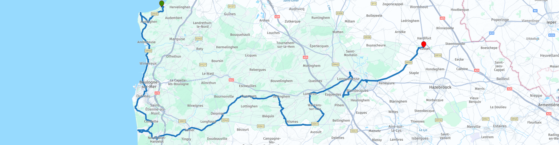
We start where the previous route ended, in Wissant, and continue on a beautiful motorcycle road until the exit for Cap Gris-Nez (Cape Gray Nose). Indeed, the rocks are a lot darker here and are still being helped by the bunkers that are still there. You can imagine that people dare to swim across the Channel. England seems very close. At RP5 you can visit the Cap Gris Nez Fort, the surrounding bunker and enjoy the view.
We continue on the D940 via Audresselles and Wimereux to Boulogne-sur-Mer. Along the way you will pass Pointe aux Oies (RP7), definitely worth a walk to the beach and enjoy the beautiful view. In clear weather you can see white Cliffs from Dover.
The next stop is in Boulogne-sur-Mer, this large town of nearly 100,000 inhabitants is one of the largest fishing ports in Europe and its history dates back to Roman times. Boulogne owns a magnificent 'National Center for Ia mer', the national maritime center at RP8, where no effort has been spared to introduce you to all facets of ocean life. It is the largest public aquarium in Europe. You can also stroll along the city walls, the terraces and along the monuments.
We drive via Equihen and go through the greenery to Hardelot-Plage. This place is spacious and has many beautiful old houses. A lot of chic from Paris used to stay here. Hardelot is as spacious and green as it is today, but Hardelot has certainly retained some grandeur of the past. If you don't want to go through this place, stay on the D119.
The route then dives into the interior. We avoid the new D308 (to the highway) and drive straight through Neufchatel-Hardelot (RP17), you then arrive on a beautiful, fast D215 over hills, through forests and the town of Samer (RP18) and along Desvres. The original route runs from Desvres via the almost straight D341 to Lumbres, so we don't do this! We drive through a detour through the Parc Naturel Régional des Caps et Marais d'Opale, much nicer roads with nice curves and beautiful surroundings.
At RP23 we return to the original route and after about 6 kilometers you take the exit to the left towards Lumbres. This will take you through the valley of the river Aa and you will drive via Lumbres and Longuenesse to St. Omer.
St. Omer (RP28) is a very nice place for a stop, a walk, a pinch of culture and possibly a meal, because it is full of restaurants and cafés along the old cobblestones.
In stark contrast to the tranquility and the old stones of St. Omer is the cold technique of the bunker 'd'Helfaut-wizernes', 3.5 kilometers south of the city at RP31. Here is a museum La Coupole about the early rocket technology of the V1 and V2, which eventually led to the first moon landing in 1969.
Argues is stuck to St. Omer and owns a boat lift called I'ascenseur à bateaux des Fontinettes (RP35). This is a fine example of technology from the last century. Instead of having to use five locks, the ships were able to bridge more than 13 meters of level difference in one go. This lift was in use from 1888 to 1967 and has now been replaced by a giant lock 500 meters away. Pay attention here because Here and Tom Tom do not agree with each other how to drive back to the route through the narrow streets.
We continue to Cassel, the end point of this route. Just before the top of the hill on which it lies, you will be treated to a fantastic series of turns.
Because of its beautiful roads through a beautiful area with a lot of history and the possibilities to visit sights, this ride is worth 5 ***** stars.


 Links
Links  Usage
Usage Want to download this route?
You can download the route for free without MyRoute-app account. To do so, open the route and click 'save as'. Want to edit this route?
No problem, start by opening the route. Follow the tutorial and create your personal MyRoute-app account. After registration, your trial starts automatically.  Disclaimer
Use of this GPS route is at your own expense and risk. The route has been carefully composed and checked by a MyRoute-app accredited RouteXpert for use on TomTom, Garmin and MyRoute-app Navigation.
Changes may nevertheless have occurred due to changed circumstances, road diversions or seasonal closures. We therefore recommend checking each route before use.
Preferably use the route track in your navigation system. More information about the use of MyRoute-app can be found on the website under 'Community' or 'Academy'.

Hauts de France
About this region
Hauts-de-France (French pronunciation: [o də fʁɑ̃s] (listen); Picard: Heuts-d'Franche; lit. 'Heights of France') is the northernmost region of France, created by the territorial reform of French regions in 2014, from a merger of Nord-Pas-de-Calais and Picardy. Its prefecture is Lille. The new region came into existence on 1 January 2016, after regional elections in December 2015. The Conseil d'État approved Hauts-de-France as the name of the region on 28 September 2016, effective the following 30 September.With 6,009,976 inhabitants (as of 1 January 2015) and a population density of 189 inhabitants/km2, it is the third most populous region in France and the second most densely populated in metropolitan France after its southern neighbour Île-de-France. It is bordered by Belgium to the north.
Read more on Wikipedia
View region
 Statistics
  33
33Amount of RX reviews (Hauts de France)
 26483
26483Amount of visitors (Hauts de France)
 2309
2309Amount of downloads (Hauts de France)
 Route Collections in this region
 24 Magnificent trails in France
It is clear that France is one of the most beautiful and best touring countries. It offers an incredibly varied landscape with good roads and a pleasant climate. It is not for nothing that you see so many motorcyclists there. My previous collection of 25 routes in France (25 Magnificent routes in France) were based on the route descriptions from the Motortourgids France part 1 made by Bert Loorbach.
This collection of 24 routes comes from Motortourgids France part 2. In this collection, a difference has been made between approach routes and motorcycle tours in a certain area. The approach routes can also be used in combination with the routes from Motortourgids France part 1
The routes are sometimes slightly adjusted based on the tips that Bert Loorbach gives in his description, or because of another place to spend the night, or to reach the minimum length of 2 hours for the MRA Library. For each route, the review contains a more detailed description, including options to stay overnight or places of interest along the way, which are also indicated with a POI and if possible with a short description.
Two or more routes have been created for a number of areas, such as for Burgundy, Auvergne, The Alps, Tarn and Cévennes and Nord-Pas de Calais. These routes can be nicely combined in a multi-day trip.
View Route Collection
The 10 most downloaded routes in France from RouteXpert Catherine De Groote
Hello and welcome to this collection of the Top 10 MyRoute app downloaded routes in France.
A great new event will be announced soon, where all of these routes can be driven.
Download them all now and place them in a new "Top 10" folder so that you always have them at hand.
If you are going to drive one of these routes in the meantime, track them with the MRA Mobile App or with MRA Navigation. Take some photos (moments) along the way as they will come in handy.
Create a travelogue of your Top 10 driven routes and add the recorded track to it.
There will also be some great prizes on offer, so keep an eye on the MRA-RouteXperts page and your email.
View Route Collection