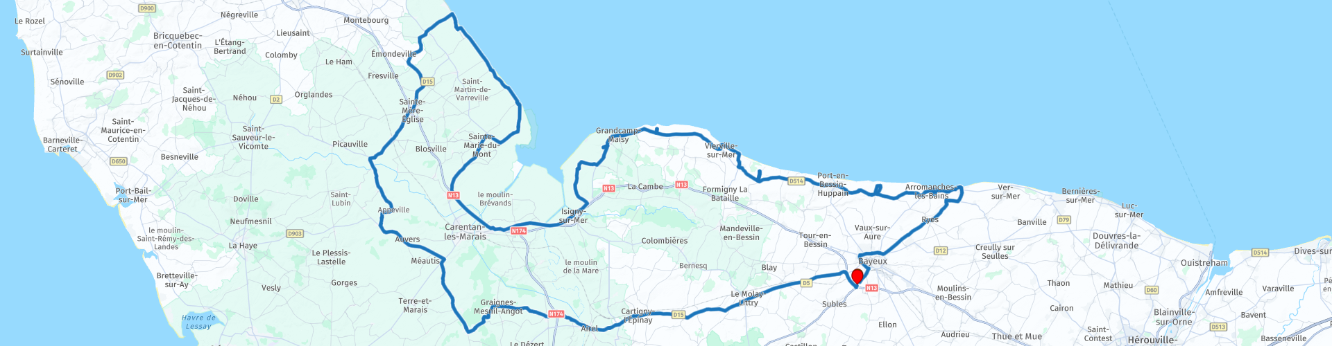
Roundtrip from Bayeux along testimonials and the landing beaches of WWII

This route was brought to you by:
RouteXpert Catherine De Groote RouteXpert
Last edit: 18-12-2023
 Route Summary
 Normandy has a rich and turbulent history. For that reason alone, a tour of this beautiful region is worthwhile. You drive past monuments, museums and the landing beaches of World War II. Too much to visit everything at once. So you will have to make a choice… and come back later or spread the tour over several days.
 Share this route


Animation

Verdict


Duration
10h 16m

Mode of travel
Car or motorcycle

Distance
204.52 km

Countries

 RouteXpert Review
 Le Musée Mémorial de la Bataille de Normandie uses 2,300 m² of exhibition space to present the military operations that took place during the Battle of Normandy in the summer of 1944. Opened in 1981, the museum is located in the heart of one of the strategic sites of the Battle of Normandy - Bayeux, the first town in mainland France to be liberated on June 7, 1944.
Just past the roundabout you come to the Commonwealth War Cemetery of Bayeux. The British Military Cemetery is managed by the Commonwealth War Graves Commission. The site has been forever assigned to the United Kingdom by France and contains more than 4,258 headstones. They show the soldier's name and rank and the weaponry of his unit. Sometimes the families have added personal epitaphs. At the foot of the tombs, a small flower garden invites contemplation.
Continue via the bypass around Bayeux to the coast and the landing beaches.
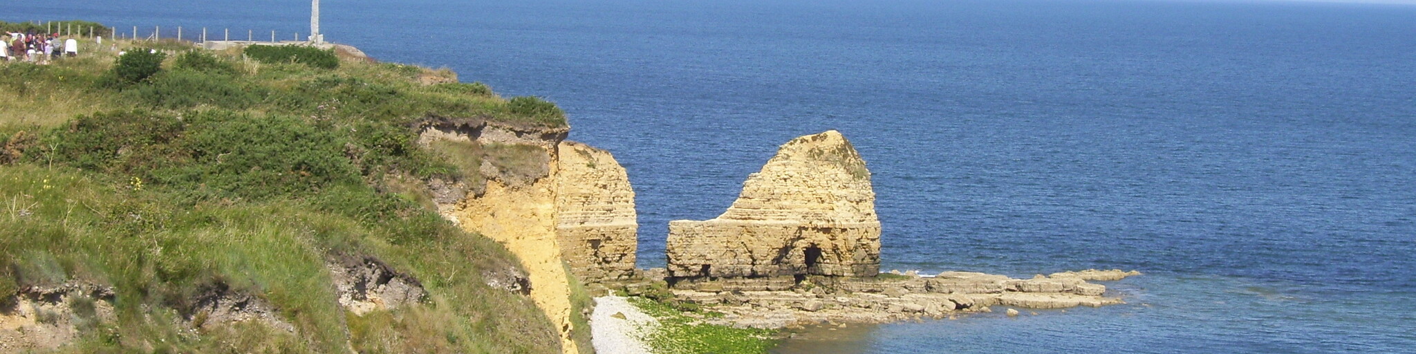
Batterie d'Asnelles - Gold Beach - is one of the works of art of the mur de l'Atlantique. The battery is a building of the organization Todt in 1942. The position of an important role for the armed forces of the Normandy from June 6, 1944.
In preparation for Operation Overlord, Allied strategists decided they needed two artificial, prefabricated ports in Normandy. These were considered essential for bringing reinforcements and equipment to the mainland. The remains of the port of Arromanches are still visible as silent witnesses to this daring gamble and astonishing engineering achievement.
Located on the cliffs of Arromanches, the Arromanches 360 ° cinema dominates the remains of one of the two artificial Mulberry harbors set up by the Allies. This film pays tribute to the men of all nations who fell and the 20,000 civilians who died in the liberation of Western Europe who gave so much hope. A technical and artistic performance that collects archival images, most of which have not been published and come from funds from various countries, such as Canada, the United States, Germany, England and France.
You can stop to take a photo of the M4A2 Sherman tank of General Leclerc 2nd Armored Division, of the free French forces, which is dedicated to the landing at Gold Beach in 1944.
The Musée du Débarquement is located in the town of Arromanches-les-Bains, the geographic center of the D-Day beaches. It is located exactly at the point where, from June 7, 1944, the Allies implanted one of the two artificial ports responsible for supplying the troops involved in the Battle of Normandy.
After or before visiting the museum, also discover the ruins of the artificial harbor and the monuments near the site.
The German artillery battery at Longues-sur-Mer was perfectly located to counter the landings of June 6, 1944. The guns were right between Omaha and Gold Beaches. On D-Day, this battery fought a duel with the Allied fleet before being silenced at sunset. The German artillery battery may not have been the most powerful in Normandy, but it was one of the best locations to withstand the June 6, 1944 landings.
The tour continues via the harbor of Port-en-Bessin-Huppain to Colleville-sur-Mer. At the roundabout, take the 3rd exit to the Overlord Museum car park.
The Overlord Museum describes the period from the Allied landing to the liberation of Paris. The collection was collected by someone who was both a witness to the conflict and involved in the reconstruction of Normandy. Personal items of individual soldiers and armored fighting vehicles of the six armies in Normandy are presented as a series of reconstructions with more than 35 vehicles, tanks and cannons.
After the visit, take the 2nd exit at the roundabout and drive to the Normandy American Cemetery. The cemetery, at the north end of the half-mile access road, covers 172.5 acres and contains the graves of 9,385 of our military dead, most of whom died in the D-Day landings and subsequent operations. On the Walls of the Missing, in a semicircular garden on the east side of the monument, 1,557 names are inscribed. Rosettes mark the names of those who have since been found and identified.
The Omaha Beach Memorial Museum is built on the site of the United States Navy landing of June 6, 1944, 200 meters from Omaha Beach. The museum covers an area of 1,200 m² and presents a large collection of uniforms, personal effects, weapons and military vehicles. All items on display were from WWII soldiers.
There are 2 monuments on the coastline. Les Braves Omaha Beach Memorial consists of three elements: The wings of Hope - Rise, Freedom! - The Wings of Fraternity.
The Omaha Beacht Monument was erected in memory of the fallen Allied soldiers who landed on Omaha Beach. The Americans had many victims (about 2000 Americans died here).
The next stop is at the Pointe du Hoc Ranger Monument. It sits on a cliff eight miles west of the Normandy American Cemetery, which overlooks Omaha Beach. It was founded by the French in honor of the American Second Ranger Battalion under the command of Lieutenant Colonel James E. Rudder. During the American attack on the beaches of Omaha and Utah, these US Army Rangers climbed the 100-foot cliffs and confiscated German artillery pieces that could have fired at US landing troops on the beaches of Omaha and Utah.
Maisy Battery was one of the largest German defensive positions in the US landing area on D-day. It had the role of defending the coast behind the western end of the Omaha Sector and at the southern edge of the Utah Sector. Today it is open to the public after being buried for over 60 years and you can walk through more than 2 miles of original German trenches. You can enter bunker after bunker as you walk around this amazing place.
You are now driving around the Bay of Veys. Just before Carentan you can visit the Normandy Victory Museum. Inside the museum you'll find cabinets of interesting artifacts, including civilian personal items and other items related to life under the occupation, plus military equipment and examples of soldiers' personal belongings. There are also about 17 life-size dioramas that are of a very high standard and of the same quality as those in the Overlord Museum in Colleville-sur-Mer, near Omaha Beach.
The pont-canal (canal bridge) over the Canal de Carentan was designed to take into account the vulnerability of the wetlands. The 20th-century piece of art is unique in France and provides for the passage of the four-lane RN13 under the water basin between the marina and the sea. One of the main problems of this design is withstanding the hydrostatic impact caused by the presence of a body of water lying practically on the surface and the fact that the roadway runs 10 meters below the canal. Pumps provide drainage and there is permanent supervision. For aesthetic reasons, the architect designed the struts to absorb the thrust of the side walls as the skeleton of the hull of a wooden boat.
Vast pastures and pasture land divided by moats and dotted with peat, where horses and cattle graze, where the waters of the Douve, the Taute and the Sève flow into the cove of the bay les Veys, where a colony of seals live, traditional hedges on elevated areas and polders near the sea: you are in the area of the marshes of Carentan.
This same area was also the scene of a life-and-death battle of the 101è Airborn Division in 1944, which was parachuted over the marshes between Angoville-au Plain and Carentan.
Built on the beach where the first US troops landed on June 6, 1944, the Utah Beach D-Day Museum tells the story of D-Day in 10 sequences, from landing preparation to final result and success. This comprehensive chronological journey immerses you in the history of the landing through a rich collection of objects, vehicles, materials and oral histories.
You will now drive along the bay of the Seine for about 10 km, the ideal opportunity to take some nice photos. When you leave the coastline, you will encounter two batteries in a short time.
The Saint-Marcouf (or Crisbecq) artillery battery was instrumental in the D-Day landings, as it challenged the Allied fleet off Utah Beach and resisted the advancement of US forces. The museum lets you discover how the defense of the German army along the 'Atlantic Wall' was organized.
The Azeville Battery is located six miles from Utah's beach in the Cotentin. It is one of the first defensive installations of the Atlantic Wall in France. The Azeville battery consists of four casemates: two Regelbau H650 type and two other Regelbau H671 type, each protecting a French-made 105mm Schneider gun.
Located in the heart of the Cotentin peninsula in Normandy, Sainte Mere Eglise was the first village in Western Europe to be liberated in WWII. The events of June 6 when American airborne troops jumped from their planes above the village make the village the most famous French village in America. In Sainte Mere Eglise they have not forgotten these heroes, quite the contrary. In addition to an interesting museum, the village and the entire area are full of monuments so that the visitor cannot miss the history of the village during D-Day. Everything in the village revolves around the airborne landing, which is actually a lot of fun. Even the church cannot escape it. It was badly damaged during the fighting and had to be restored after the war. In the church you can find a monument and a number of special stained-glass windows that visualize the events.
The Airborne Museum is located in the heart of Sainte-Mère-Eglise, a few kilometers from the landing beaches, opposite the bell tower on which parachutist John Steele has hung. Through a spectacular and realistic museography, the Airborne Museum introduces you to D-Day alongside the American paratroopers of the 82nd and 101st Airborne. From the preparation of the D-Day landings in England to the battles leading to Freedom, you will accompany the WWII airborne troops on their way to Victory, which ended the war of 1939-1945.
The way back to Bayeux goes through various wetlands. You drive through a part of the Natural Park Marais du Cotentin et du Bessin with an area of 140,000 ha (of which 27,000 ha of marshes and polders). Covering much of what used to be called the 'Marsh of Carentan', the park stretches across the southern part of the Cotentin peninsula, from Valonges in the north to Saint-Lô in the south and from Bayeux in the east. to Lessay in the west. Here you can take some nice pictures. The bocage landscape with its swamps and countless canals is rich in special plant and animal species. The relatively high vegetation in the otherwise bare wetland forms an ideal breeding and wintering place for migratory birds. In addition to the management of water levels, the transfer of information about the plant and animal world in the area is the main objective of this nature park.
This route receives 4.5 stars. This ride takes you to monuments, museums and the landing beaches of World War II that follow each other very quickly. The trip is perhaps best spread over 2 or 3 days. There is busy tourism along the coastline. Once inland it is a quiet drive along beautiful roads.


 Links
Links  Usage
Usage Want to download this route?
You can download the route for free without MyRoute-app account. To do so, open the route and click 'save as'. Want to edit this route?
No problem, start by opening the route. Follow the tutorial and create your personal MyRoute-app account. After registration, your trial starts automatically.  Disclaimer
Use of this GPS route is at your own expense and risk. The route has been carefully composed and checked by a MyRoute-app accredited RouteXpert for use on TomTom, Garmin and MyRoute-app Navigation.
Changes may nevertheless have occurred due to changed circumstances, road diversions or seasonal closures. We therefore recommend checking each route before use.
Preferably use the route track in your navigation system. More information about the use of MyRoute-app can be found on the website under 'Community' or 'Academy'.

Normandy
About this region
Normandy (/ˈnɔːrməndi/; French: Normandie [nɔʁmɑ̃di] (About this soundlisten); Norman: Normaundie; from Old French Normanz, plural of Normant, originally from the word for "northman" in several Scandinavian languages)[2] is a geographical and cultural region in Northwestern Europe, roughly coextensive with the historical Duchy of Normandy.
Normandy comprises mainland Normandy (a part of France) and the Channel Islands (mostly the British Crown Dependencies). It covers 30,627 square kilometres (11,825 sq mi).[3] Its population is 3,499,280. The inhabitants of Normandy are known as Normans,[1] and the region is the historic homeland of the Norman language. Large settlements include Rouen, Le Havre and Cherbourg.
The cultural region of Normandy is roughly similar to the historical Duchy of Normandy, which includes small areas now part of the departments of Mayenne and Sarthe. The Channel Islands (French: Îles Anglo-Normandes) are also historically part of Normandy; they cover 194 square kilometres (75 sq mi)[4] and comprise two bailiwicks: Guernsey and Jersey, which are British Crown Dependencies.
Normandy's name comes from the settlement of the territory by Vikings ("Northmen") starting in the 9th century, and confirmed by treaty in the 10th century between King Charles III of France and the Viking jarl Rollo. For four hundred years following the Norman conquest of England in 1066, Normandy and England were linked by having the same person reign as both Duke of Normandy and King of England.
Read more on Wikipedia
Normandy comprises mainland Normandy (a part of France) and the Channel Islands (mostly the British Crown Dependencies). It covers 30,627 square kilometres (11,825 sq mi).[3] Its population is 3,499,280. The inhabitants of Normandy are known as Normans,[1] and the region is the historic homeland of the Norman language. Large settlements include Rouen, Le Havre and Cherbourg.
The cultural region of Normandy is roughly similar to the historical Duchy of Normandy, which includes small areas now part of the departments of Mayenne and Sarthe. The Channel Islands (French: Îles Anglo-Normandes) are also historically part of Normandy; they cover 194 square kilometres (75 sq mi)[4] and comprise two bailiwicks: Guernsey and Jersey, which are British Crown Dependencies.
Normandy's name comes from the settlement of the territory by Vikings ("Northmen") starting in the 9th century, and confirmed by treaty in the 10th century between King Charles III of France and the Viking jarl Rollo. For four hundred years following the Norman conquest of England in 1066, Normandy and England were linked by having the same person reign as both Duke of Normandy and King of England.
View region
 Statistics
  15
15Amount of RX reviews (Normandy)
 18670
18670Amount of visitors (Normandy)
 1528
1528Amount of downloads (Normandy)
 Route Collections in this region
 3 day mini break through Brittany and Normandy
The overnight ferry crossing from Plymouth to Roscoff is a relaxing way to begin your 3 days of sightseeing in North West France. Touring the coasts and countryside of Brittany and Normandy, you'll discover beautiful sandy beaches, tiny fishing ports, bustling market towns and iconic and historical sites. Don't forget to sample Brittany's renowned seafood and delicious sweet and savoury pancakes, or Normandy cider and of course their 'hard to say no to' apple brandy, Calvados .
Day 1 takes you along the beautiful and rugged coast to Mont St Michel, a World Heritage site, visible for miles around. This is a wonderful place at any time of year, although be prepared for it to be very busy in summer. Your first hotel is just 30 minutes further along the coast at Hôtel Ibis Avranches Baie du Mont Saint-Michel. Other hotels are nearby and links for this hotel and your second night at Port en Bessin are in the individual route reviews.
Day 2 takes you first to Bayeux, world famous for its astonishing tapestry depicting the Norman Conquest of England in 1066, remarkable as a work of art and important as a source for 11th-century history. Bayeux also has a picturesque old quarter, WW2 museum and cathedral worth visiting (park motorcycles next to cathedral).
Then you can take in the sobering atmosphere at Pegasus Bridge, liberated by the British 6th Airborne Division glider unit, a full size replica of a Horsa glider shown in the picture above is on display, and the tale of the men it transported gives you a remarkable insight into the scale, ferocity and poignancy of Operation Overlord. Arromanches' Mulberry Harbour (Port Winston) and the gun emplacements dotted along the coast that you'll visit are reminders of the combats that took place here over 70 years ago. A great night is guaranteed at your second hotel in the fishing port of Port en Bessin where you can sample local cider (cidre) some of the freshest seafood available, fine wine, and finish off with some local calvados.
Day 3 tells the American story of D-Day with visits to Omaha and Utah beaches, various museums and the first town in France to be liberated during operation Overlord - Sainte-Mère-Eglise where an effigy of private John Steele dangles by his parachute from the church steeple.
Your return to the UK is via Cherbourg, to either Poole or Plymouth depending on the time of year, most sailings are around 17:00 hrs. Details from Brittany Ferries can be found in the link in the first review.
This is a great mini tour that'll give you a good glimpse of what this part of northern France has to offer and will leave you wanting to return.
View Route Collection
The 10 most downloaded routes in France from RouteXpert Catherine De Groote
Hello and welcome to this collection of the Top 10 MyRoute app downloaded routes in France.
A great new event will be announced soon, where all of these routes can be driven.
Download them all now and place them in a new "Top 10" folder so that you always have them at hand.
If you are going to drive one of these routes in the meantime, track them with the MRA Mobile App or with MRA Navigation. Take some photos (moments) along the way as they will come in handy.
Create a travelogue of your Top 10 driven routes and add the recorded track to it.
There will also be some great prizes on offer, so keep an eye on the MRA-RouteXperts page and your email.
View Route Collection