The Lake District Passes Clockwise

This route was brought to you by:
RouteXpert Nick Carthew - (MRA Master)
Last edit: 12-03-2025
 Route Summary
 I rode this route in June 2015, The landscapes alone make this a 5***** star route.
 Share this route


Animation

Verdict


Duration
6h 46m

Mode of travel
Car or motorcycle

Distance
182.59 km

Countries

 RouteXpert Review
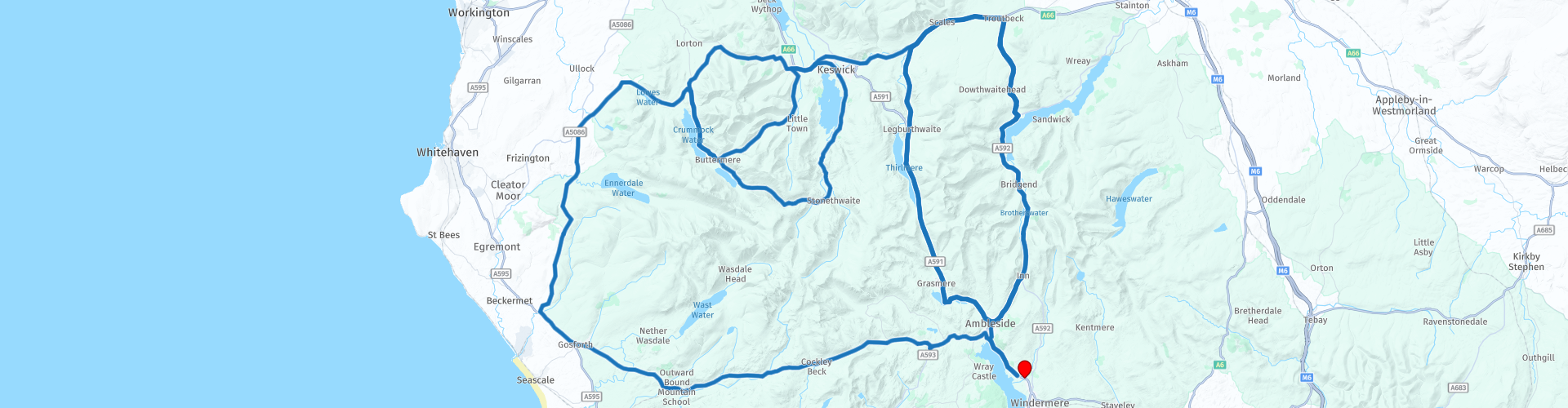
 In order, the passes are:
Wrynose Pass.
Hardknott Pass.
Newlands Pass.
Honister Pass.
Whinlatter Pass.
Kirkstone Pass.
Bonus: The Struggle
The Wrynose Pass is a mountain pass between the Duddon Valley and Little Langdale. The unusual name, Wrynose, comes from ‘pass of the stallion’ and referred to the fact that the steep gradients (up to 1 in 3) needed a well-muscled horse to attain the top. At the top of the Wrynose Pass is the Three Shire Stone, marking the meeting point of the historic counties of Cumberland, Lancashire and Westmorland.
The Hardknott Pass is the trickiest with tight bends on a bumpy surface all at a 30% gradient, the views from the top are well worth the effort though. The pass is described as one of the most challenging roads in Britain and shares the title of steepest road in England with Rosedale Chimney Bank in Yorkshire. There are some good remains of a Roman fort towards the end of the pass.
Newlands Pass is a three-mile-long road running along a ledge above the Newlands valley, from Buttermere to the village of Braithwaite, near Keswick. The highest point is Newlands Hause, 333 metres (1093 ft), where there is a car park, and a short walk to the Moss Force waterfalls. Newlands valley is thinly populated, consisting mainly of farms and tourist accommodation. Stair is the main settlement in the valley, and includes the Newlands Adventure Centre and the Swinside Inn, which is the only pub in the valley and is situated one kilometre to the north of Stair.
Lunch stop is at Keswick. There is a secure motorcycle park at the back of Oddfellows Arms where we had a superb lunch the but you are surrounded with other places to eat and drink if you prefer.
Honister Pass connects the eastern end of Borrowdale valley to Buttermere valley. Rising to 356 m (1167 ft) in height at the summit, it is one of Cumbria’s highest passes, with a gradient of 1 in 4. Flowing through the pass from the summit to Buttermere is Gatesgarthdale Beck. Slate mining has taken place in the Lake District for 100s of years and the last remaining mine in England is seen here on the Honister Pass. It's a great place to visit and I have included a link to their website below this review.
Whinlatter Pass winds its way through the Thornthwaite Forest, to a height of 318 m (1,043 ft) above sea level, with views over Bassenthwaite Lake. Because it travels through a forest, this pass has a different feel to the other passes. The Whinlatter Pass is a far less severe and the scenery is beautiful.
Kirkstone Pass with an altitude of 454 m (1,489 ft) is the Lake District’s highest pass that is open to motor traffic. The Kirkstone Pass Inn stands close to the summit of the pass. Formerly an important coaching inn, it now caters primarily for tourists. It is the third highest public house in England and makes a great stop for refreshments and a photo.
Now comes a bonus: The Struggle. The Struggle is so called because of the steepness of the climb, you will see this as you travel down it towards Ambleside.
The Lake District Passes has to be on everyone's list of places to visit and each pass is completely different if ridden in the opposite direction. There is a link below to a reverse of this route that is also in the MRA RouteXpert Library. The whole of the Lake District is full of beautiful roads to ride and around every corner is another fantastic view.
A video of Wrynose and Hardknott Passes that I took when I rode in June 2015 can be seen in a link below.


 Links
Links  Usage
Usage Want to download this route?
You can download the route for free without MyRoute-app account. To do so, open the route and click 'save as'. Want to edit this route?
No problem, start by opening the route. Follow the tutorial and create your personal MyRoute-app account. After registration, your trial starts automatically.  Disclaimer
Use of this GPS route is at your own expense and risk. The route has been carefully composed and checked by a MyRoute-app accredited RouteXpert for use on TomTom, Garmin and MyRoute-app Navigation.
Changes may nevertheless have occurred due to changed circumstances, road diversions or seasonal closures. We therefore recommend checking each route before use.
Preferably use the route track in your navigation system. More information about the use of MyRoute-app can be found on the website under 'Community' or 'Academy'.