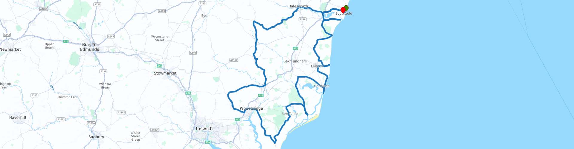
Round tour from Southwold Via Orford Aldeburgh Thorpeness and Walberswick

This route was brought to you by:
RouteXpert Paul Taylor
Last edit: 19-09-2023
 Route Summary
 This route in my opinion deserves 5***** stars because the scenery is excellent , roads and attractions are all very good.
 Share this route


Animation

Verdict


Duration
9h 6m

Mode of travel
Car or motorcycle

Distance
175.00 km

Countries

 RouteXpert Review
 The county of Suffolk (Sudfole, Suthfolc, meaning 'southern folk'), formed from the south part of the kingdom of East Anglia along with two other counties that make up this, which are Norfolk and Cambridgeshire. Settled by the Angles in the latter half of the 5th century, the Size of Suffolk 2362mile² (3,801km²) compared to Norfolk at nearly twice its size at 3337mile² (5371km²). Orford, Aldebourgh, Thorpeness, Sizewell, Walberswick and Southwold are all in the Suffolk coast and heaths area of outstanding natural beauty (AONB). This special designation covers 274 miles² (441km²) of tranquil and unspoilt landscape including wildlife-rich estuaries, ancient heaths, windswept shingle beaches and historic towns and villages. If you love nothing more than a long walk beside the sea or a brisk stroll before lunch, cycling along quiet lanes, sailing iconic estuaries, or even spending hours quietly watching some of the UK's rarest wildlife, in its natural habitat surrounded by beautiful landscape, rich in history but largely spared from modern development then Suffolk is the place to visit.
From Southwold, we head out towards Halesworth. Just after crossing over the river Blyth there is a scheduled fuel stop before moving on to Framlingham; a current day market town and civil parish in Suffolk of anglo-Saxon origin. Framlingham appears in the 1086 Domesday Book, with its 12th century medieval castle that through the centuries once belonged to the Earls and Dukes of Norfolk. Initially built out of wood by the Bigods, a powerful Norman family, the building work took place sometime between 1066 and 1107. The first stone buildings at the site were probably the work of Hugh Bigod, 1st Earl of Norfolk (d.1177), it was later confiscated from the powerful Bigod family by King Henry II. It was said that ‘to evade capture’, Mary Queen of Scots fled to Framlingham Castle in 1553, where she rallied her catholic supporters and gathered a military force, who proclaimed her Queen of England. The site is now owned and run by English Heritage and is open to the public. There is an entrance fee of £12.80pp, with a free carpark available to English Heritage members and a small fee for non-members.
Leaving Framlingham behind you and just before Wicken Market you cross over the river Debden. Here you enjoy an 11-mile ride before reaching the A12; the main arterial road from Ipswich to Lowestoft. There will be a very short ride on this road before joining the B1083, where just outside of Woodbridge once again you cross back over the river Debden. Continue on this road, crossing over the river Butley prior to reaching the village of Orford which was rated 11th in the top 20 most beautiful villages in the UK. Here stands a medieval castle built by Henry II between 1165-1173. Orford Castle is a 90ft (27m) high structure, built of septaria, limestone, mudstone, and Coralline Crag and sits dominating the river Ore. It was said that there is ‘something mesmerising’ about this coastal village with its 10 mile (16km) long shingle spit of Orfordness. In the 1930’s, it was famously known as the site of the first purpose-built experiments on the defence system that was later be know as ‘radar’. Orfordness was also home to the lighthouse. Built in 1792 and standing at 98ft (29.9m), this iconic landmark was sadly demolished in 2020 due to high tides and harsh weather. Like so many other Suffolk coastal towns, Orford was of high importance as a port and fishing village in the Middle Ages. A great stop for some well deserved lunch as there are a few places to choose from, to suit most taste.
From here you head towards Aldeburgh where there is a route option to visit Snape Maltings; said to be Suffolk's international destination for music, culture, shopping, food, drink and beautiful days out. Just after leaving the Malting, you will cross the river Alde and continue on to Aldeburgh where there is a route option to visit The Red House, another important building as this is where the iconic Suffolk composer Benjamin Britten and his partner, singer Peter Pears, once lived and worked. Today “The Red House” is the home of the Britten - Pears Foundation, where you are invited to discover where the musical magic happened. The Studio where Britten composed is open to visitors all year-round, as is the Gallery, the historic Library, and the Gardens. The House itself is open during the summer months with free admission. However, there is a small charge for the carpark. , rated 1st in the top 10 best beaches in Suffolk. Once an important Tudor port where its shipbuilders were responsible for Francis Drake's 'Golden Hind'. But over time the river Alde silted up taking its toll on the town's fortunes, and coastal erosion swept away the heart of its old town. Just outside the town you can explore the Martello Towers. Owned and run by the Landmark Trust, these are the largest and most northerly of the Towers built to keep Napoleon out. These were round structures about forty feet high with thick walls and wide roofs. A total of eighteen towers were built along the Suffolk coastline. Why not take some time to wander along the coast and take in the fascinating architecture and history behind these magnificent buildings . Just along from here is the grade 1 listed building Moot Hall designed in the Tudor style, was built using timber frame construction techniques with wattle and daub and brick nog infilling, it was completed around 1520 where it was used for the borough council to meet. In 1645 it was the location for the trial, under the direction of the witchfinder general, Matthew Hopkins, of seven alleged witches who were subsequently hanged.
Just outside of Aldeburgh on your right-hand side on the beach is where you can see the Scallop artwork, it is a 13ft (4m) high monument, created by local-born artist Maggi Hambling, to the late Benjamin Britten, composer and past Aldeburgh resident, who used to take his afternoon walks along the beach. From here follow the road for about 1.3 miles (2.1km) that brings you nicely into Thorpeness, rated 8th in the top 10 of the most beautiful village in Suffolk . The story of Thorpeness goes back to 1859, when a Scottish railway engineer named Alexander Ogilvie purchased the land. In 1910 severe storms flooded the area, and during a eureka moment, Ogilvie decided that the flooded land should became a boating lake! The lake now called the ‘The Mere’ was dug out by hand at a depth of 3ft and consisted of 64 acres. Ogilvie changed its name from Thorpe to Thorpeness to distinguish it from other villages and created a holiday village based around the lake. With its mock Tudor and Jacobean houses, it was often described as Neverland from Peter Pan because Thorpeness was promoted as “The Home of Peter Pan”. JM Barrie, author of The Boy Who Wouldn’t Grow Up (Peter Pan), was a close friend of the Ogilvies and regularly visited the village. His characters inspired the magical little islands in the centre of the famous Meare. The landings are still marked with names from the storybook, and you can find locations such as the pirates lair and Wendy’s home, to play on.
As you leave Thorpeness in front of you is the Margaret Ogilvie Almshouses that was erected in 1926, (also known as a bede-house, poorhouse, or hospital) originally for the workmen of the Ogilvie that helped form part of his fantasy holiday village. Applicants had to be over 55 of good character and resided in the county of Suffolk, further on from here if you take a sideward glance to your left you will see in the distance “The House in the Clouds” it is one of the most striking features of Thorpeness, one that can be seen sitting atop the horizon from the nearby beaches at Aldeburgh, it is the 70ft house on stilts, commonly known as ‘The House in the Clouds’. When Ogilvie set about making his quaint, ornate village, the huge and unsightly water tower to the North of the Meare proved a problematic blemish in his idealistic vision. Originally intended to provide an adequate storage capacity for the village’s basic water supply of 50,000 gallons and was capable of pumping 1800 gallons of water an hour from a well in the re-erected Aldringham Mill, the tank at the top of the water tower was designed to look like a fairytale cottage, with accommodation in the stalk below.
It is a short ride from here of approx. 4.5 miles (7.2km) to Sizewell, once a small fishing hamlet but now the site of two nuclear power stations with one that is still active. Its marshes form a 260-acre biological Site of Special Scientific Interest on the edge of Sizewell. It is noted for its rare invertebrates and bird species, and as one of the main wetlands in East Anglia for wildflowers. The beach was the landing site of Henri Peteri and his brother Willem, were in September 1941 it took 56hrs in a foldable canoe to make the 100 miles treacherous crossing of the North Sea to escape from the German occupation of holland and were known as Engelandvaarders. There is ample free parking for motorbikes, a café to take on some refreshments and toilet facilities or why not take a gentle stroll on the large open pebble beach.
After leaving Sizewell there is a route option to turn left and follow for 0.2 miles (0.3km) to visit Leiston Abbey a 14th-century remains of an abbey of Premonstratensian canons. Now run and owned by English Heritage, open at reasonable times during daylight hours, with free entry and parking (On gravel), further on from here on your right you can also see from the road the ruined base is all that remains of a tower mill which was moved to Theberton from Little Glemham in about 1730. It worked until about 1920 and was demolished by 1930.
Once through Westleton we branch of to Dunwich to visit Greyfriars monastery, established by Franciscan monks, who first came to Dunwich in the 1250s and set up a monastic house near the harbour. A massive storm, on New Year's Eve in 1286, destroyed their building, along with much of the harbour facilities and many homes in the lower part of the town. The monks were then given land just outside the old town boundary to the west, half a mile from the sea, and started building the monastery whose remains you see today. Next it is onto Walbeswick, once ranked 13th of the best coastal hotspots to live in Great Britain. A Georgian village that lies on the south bank of the river Blyth once a busy port trading in fish, cheese, corn, bacon and timber from as early as the 13th century right up to the First World War. With its long wide sand and shingle beaches popular with surfers and kite surfers alike, backed by grassy dunes and surrounded by marsh and heathland. The nature reserve, which follows the river Blyth estuary, covers over 1,000 acres, combining mudflats, meadows and marsh and is home to otters, deer and a wide range of bird species so both wild and a pretty wonderful place to visit.
Taking the same road back out of Walbeswick’s that you took in, you will pass the magnificent Blyth estuary on your right, before shortly finishing the route in Southwold and where in the distance you can see Southwold’s old water tower. Southwold was mentioned in the great Domesday Book (1086) as a fishing port, and after the "capricious River Blyth withdrew from Dunwich in 1328, bringing trade to Southwold in the 15th century", it received its town charter from Henry VII in 1489. Surprisingly only rated 3rd in the top 10 best beaches in Suffolk. On the green just above the beach, it is descriptively named Gun Hill, where six 18-pounder cannons that commemorate the Battle of Sole Bay, fought in 1672 between English and French fleets on one side and the Dutch (under Michiel de Ruyter) on the other. The battle was bloody but indecisive and many bodies were washed ashore. Southwold Museum has a collection of mementos of the event. Also, the famous Adnams brewery is located here, where the earliest record of beer being brewed at the site, is from 1345. "Ale wife" Johanna de Corby and 17 others were charged by the manorial court for serving illegal measures. George and Ernest Adnams purchased the Sole Bay Brewery from William Crisp where two years later, the partnership was formally dissolved. It wasn’t until 1890 that the now well-known Adnams and Co. was established and has remained independently run ever since. The brand is now sold in 33 countries around the world, and it all came from humble origins of a horse drawn cart deliveries just to the local pubs, a tradition that was kept alive for hundreds of years, but that sadly ended in 2006. Just situated near the centre of this seaside resort; conveniently midway between Lowestoft and Orford is Southwold lighthouse, built in 1887, this conical shaped tower is constructed of masonry and sits 121ft (37m) above sea level. Fully automated and electrified in 1938, its main led light reaches 17 to 24 Nautical Miles out to sea, still in used today as a coastal mark for passing shipping and as a guide for vessels sailing into Southwold Harbour. It featured in the BBC children's television series Grandpa in My Pocket. A little way from here situated at the northern end of the town lays Southwold Pier, it was built at the end of the Victorian era in 1900, with its breath-taking sea views and eccentric British seaside fun. It was originally 810ft (247m) long but now only 623ft (190m) long that reaches out into the North Sea. Originally used as a landing stage for the Belle steamships that travelled from London Bridge, Clacton, and Great Yarmouth until the 1930s. The pier is now home to several shops, attractions including traditional souvenir shops, Restaurants, cafés, and amusement arcades.


 Links
Links  Usage
Usage Want to download this route?
You can download the route for free without MyRoute-app account. To do so, open the route and click 'save as'. Want to edit this route?
No problem, start by opening the route. Follow the tutorial and create your personal MyRoute-app account. After registration, your trial starts automatically.  Disclaimer
Use of this GPS route is at your own expense and risk. The route has been carefully composed and checked by a MyRoute-app accredited RouteXpert for use on TomTom, Garmin and MyRoute-app Navigation.
Changes may nevertheless have occurred due to changed circumstances, road diversions or seasonal closures. We therefore recommend checking each route before use.
Preferably use the route track in your navigation system. More information about the use of MyRoute-app can be found on the website under 'Community' or 'Academy'.

East of England
About this region
The East of England is one of the nine official regions of England. This region was created in 1994 and was adopted for statistics purposes from 1999. It includes the ceremonial counties of Bedfordshire, Cambridgeshire, Essex, Hertfordshire, Norfolk and Suffolk. Essex has the highest population in the region.The population of the East of England region in 2018 was 6.24 million.Bedford, Luton, Basildon, Peterborough, Southend-on-Sea, Norwich, Ipswich, Colchester, Chelmsford and Cambridge are the region's most populous towns. The southern part of the region lies in the London commuter belt.
Read more on Wikipedia
View region
 Statistics
  19
19Amount of RX reviews (East of England)
 18921
18921Amount of visitors (East of England)
 941
941Amount of downloads (East of England)
 Route Collections in this region
 The Ultimate 10 Day (North) UK Tour
Starting from and returning to Harwich ferry port, this tour follows the east coast of England up to the Highlands of Scotland and returns via the Lake District. It visits 6 of the UK's national parks and explores 2 islands and visits 2 James Bond 007 film locations.
Daily highlights.
Day 1, Harwich to Wells Next the Sea:
Southwold lighthouse, Cromer Crab lunch and sleeping on a Dutch barge.
Day 2, Wells Next the Sea to Middlesbrough:
Royal Sandringham Estate, Humber Bridge, a lap of Oliver's Mount, North York Moors National Park, Whitby Abbey the inspiration for Dracula.
Day 3, Middlesbrough to Dundee:
Tees Transporter Bridge, Angel of the North, Bamburgh Castle, Holy Island of Lindisfarne.
Day 4, Dundee to Inverness:
Cairngorms National Park, Balmoral Castle, Whisky Distilleries.
Day 5, Inverness to Ullapool:
Exceptional Landscapes, Falls of Shin, Loch Drumbeg Viewpoint, Kylesku Bridge.
Day 6, Ullapool to Dornie:
Kinlochewe viewpoint, Applecross Pass, Isle of Skye.
Day 7, Dornie to Keswick:
Eilean Donan Castle (007), Glencoe Pass, Glen Etive (007), Loch Lomond and Trossachs National Park.
Day 8, Keswick to Kendal:
A tour of the Lake District National Park visiting 6 of the best passes including Wrynose Pass and Hardknott Pass and 7 of the great lakes including Ullswater and Windermere.
Day 9, Kendal to Matlock:
Yorkshire Dales National Park, Ribblehead Viaduct, Peak District National Park, Snake Pass, Matlock Bath (motorcycle Mecca).
Day 10, Matlock to Harwich:
Heckington Windmill, Moulton Windmill, Dutch Quarter in Colchester.
By starting from Harwich, this tour avoids the traffic congestion of the south east and London making it perfect for European visitors wanting to see some of the best landscapes and sights that the north of the UK has to offer.
The cost of the ferry from Hoek Van Holland to Harwich return for motorcycle and rider costs £139.00 (163.51 Euro) (in 2019) which includes a cabin on the outward leg.
Where possible, motorways have been avoided and scenic routes are used every day.
Enjoy.
View Route Collection
8 beautiful routes through England
"8 beautiful routes through England"
You may have seen one of these routes pass by. Eight routes have been driven and made in 2018.The routes are part of a 9-day trip through England. You drive through landscapes that are varied and beautiful. You can see beautiful rolling hilly vistas.
The main roads are of reasonable to good quality, but you also drive on roads that are less maintained and there may be some gravel on the roads here and there.
In general, they are beautiful routes through a beautiful country. The routes are connecting and turn left around London. The start and end points of the routes are Hull.
The collection contains the following routes;
Day 1 from Hull to Ashbourne (224 km)
Day 2 from Ashbourne to Birdlip (245 km)
Day 3 from Birdlip to Feldbridge (295 km)
Day 4 from Feldbridge to Whitstable (250 km)
Day 5 from Whitstable to Colchester (227 km)
Day 6 from Colchester to Hinckley (233 km)
Day 7 Tour and visit Triumph Factory and National Motorcycle Museum (77 km)
Day 8 from Hinckley to Hull (262 km)
All routes have been checked and leveled for Tomtom, Garmin and MyRoute-App Navigation. The routes follow the original route as they were made at the time.
Have fun driving one of these routes. Enjoy all the beauty that England has to offer, such as; The Clumberpark, Bolsover Castle, The Seven Sisters, The White Ciffs of Dover. Of course, a visit to the Triuph factory and the National Motorcycle Museum is also highly recommended.
View Route Collection