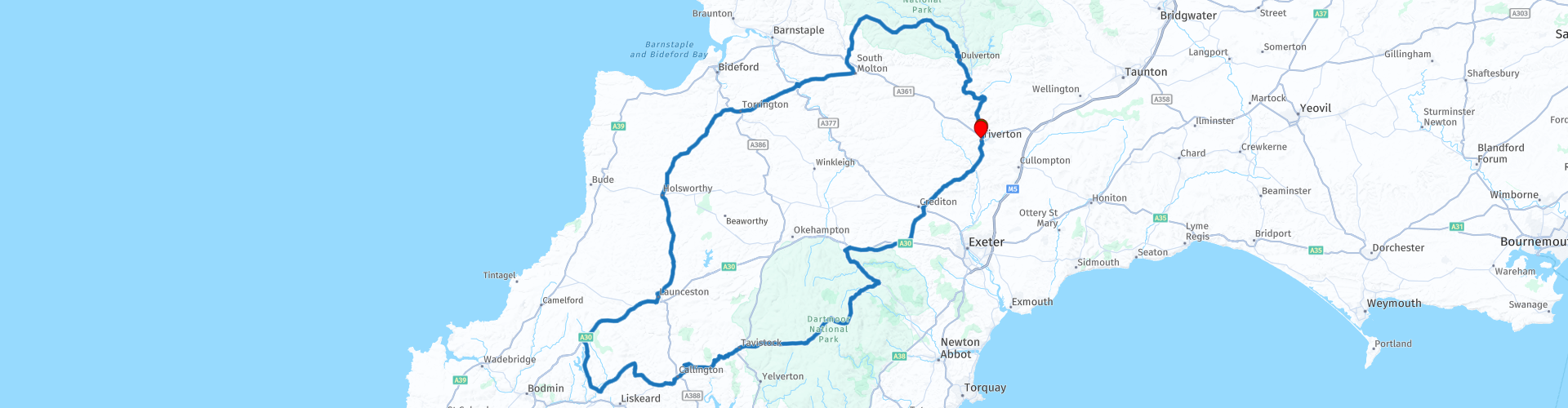
Roundtour from Tiverton visiting the 3 West Country moors Exmoor Bodmin Moor Dartmoor

This route was brought to you by:
RouteXpert Nick Carthew - (MRA Master)
Last edit: 08-10-2021
 Route Summary
 The roads are mainly very good but there are a couple of short sections of narrow single track roads. The landscape is beautiful and there are a number of great attractions to see along the way. For these reasons I have awarded this route with 4 **** stars.
 Share this route


Animation

Verdict


Duration
10h 8m

Mode of travel
Car or motorcycle

Distance
291.39 km

Countries

 RouteXpert Review
 The 3 moors ride is a favourite with many bikers living in the West Country, experience it for yourself when you are down this way. 'Tis a great day out.
Exmoor:
Exmoor was designated as a National Park in 1954. Exmoor is a unique place shaped by people and nature over thousands of years and is recognized as one of the UK's finest landscapes. Large areas of open moorland provide a sense of remoteness and tranquillity rare in southern Britain. Spectacular coastal views, deep wooded valleys, high sea cliffs and fast flowing streams all combine to form a rich and distinct mosaic. It is a landscape that has inspired poets writers and artists for hundreds of years and continues to inspire people today. It's 267 square miles is also a great landscape to travel through.
Bodmin Moor:
Bodmin Moor, at 77 square miles is the smallest of the 3 West Country moors and does not have National Park status but it is one of Cornwall's designated Areas of Outstanding Natural Beauty (AONB). Bodmin Moor is a expanse of grassland and heather punctuated by granite outcrops and strewn with boulders. Evidence of many prehistoric settlements abounds. In marshy hollows rivers such as the Fowey rise and in hidden valleys ancient oak trees remain. Most of the land lies at the comparatively low height of 200 metres and it is one of the warmest and wettest uplands in Britain though you might not think so in the snowy depths of winter.
Dartmoor:
Dartmoor, the largest of the 3 moorland areas was designated as a National Park in 1951, a vast tract of largely untamed countryside of huge richness and diversity stretching across 368 square miles. It's a landscape quite unlike any other, populated by lofty granite tors, mysterious hut circles and standing stones, ancient woodlands, sturdy clapper bridges, rushing streams, Dartmoor ponies, bustling stannary (tin mining) towns and secluded villages.
Starting from the market town of Tiverton in Devon, you follow the path of the River Exe towards Exmoor and the pretty town of Dulverton, known as the southern gateway to Exmoor National Park. You will have crossed into Somerset at Exebridge where the rivers Barle and Exe converge. Dulverton is a jewel in the far west of Somerset, where streets are lined with cosy cottages and charming restaurants. It’s tucked into a spectacular and steeply-wooded valley where the River Barle runs through. The Barle leads you to a steeply and heavily wooded road that climbs and climbs up onto the open moorland. Crossing cattle grids gives you an indication that livestock are loose and could be on the road. The views from the top of Winsford Hill are breathtaking and from here you'll have a good chance to spot some wild Exmoor ponies. They are one of a number of British native ponies and a common sight on Exmoor, where a number of managed herds graze the rough pasture. The ponies are only ‘wild’ in the sense that the herds roam freely on the moor, for all the ponies belong to someone. There are around twenty different herds that run on the various commons of Exmoor, two of which are owned by the National Park. From the times of Woolly Mammoths and Sabre Tooth Tigers, ponies existed in the UK. Exmoor has remained well off the beaten path until relatively recent times (to this day we would say Exmoor is well tucked away). This preserved their ancient lineage, hence reference to the Exmoor Pony as one of the oldest known horse breeds.
Drop down from the high moor to Withypool Tea Room that sits next to the River Barle and it's as picturesque a place to stop for a coffee as you'll ever find. Many bikers and car enthusiasts stop here for some of their delicious homemade snacks and fresh coffee. The bridge over the Barle is a great place for some photos.
After your coffee break, head out from Withypool and climb high again up onto Withypool Common another large area of open moorland offering great views behind you. More great views can be had a few miles further on at a spot known as Two Barrows. Here you'll see a grassy mound known as a barrow. This and others in the area are Bronze Age burial mounds and date back 3000 years or more. This is the highest point of the route at 483 m above sea level. On a clear day you can see The coast at Hartland Point, Dartmoor to the south and on a very clear day Brown Willy on Bodmin Moor, Cornwall's highest hill at 420 m.
Slowly descending from the high moorland the route now travels back into Devon. Beautiful Devon countryside takes you to Umberleigh where a bridge crosses over the River Taw. The River Taw is perhaps most famous as the setting for Henry Williamson's very popular book; Tarka the Otter. Stop and take some photos in this idyllic spot.
The next section of road is known locally by bikers as 'The Big Dipper' road, this will become clear to you as it resembles the track of a roller coaster. The Big Dipper takes you to the market town of Great Torrington and on the edge of town is Torrington Commons a local meeting point for bikers so I have suggested another coffee stop here.
There's more beautiful Devon countryside to enjoy now on some great roads that will see you cross the River Tamar into Cornwall.
The River Tamar forms most of the border between Devon and Cornwall. The Tamar's source is less than 3.7 miles from the North Cornish coast, it flows southeastward and its course runs across the peninsula to the south coast. The total length of the Tamar is 61 miles. If it wasn't for the 3.7 miles at the Tamar's head, Cornwall would be an island!
You'll join the A30 major trunk road at Launceston but you're only on it for 10 miles, take the exit for Bolventor and The Jamaica Inn.
I have suggested another coffee stop at The Jamaica Inn. Cornwall's most famous smugglers inn made world-famous by Daphne du Maurier's Jamaica Inn novel. You are now on Bodmin Moor the smallest of the 3 West Country moors.
After your coffee break you'll soon see Dozmary Pool.
The mysterious Dozmary Pool on Bodmin Moor. There are many myths and legends attached to this small lake just south of Bolventor, not least its name; this is reputedly derived from 'Dozy Mary', an unfortunate girl who was murdered here.
Among the other legends are that this is the resting place of King Arthur's sword, 'Excalibur' - this is the lake of 'Lady of the Lake' fame.
Dozmary Pool is also the location of one of Jan Tregeagle's trials. It is said he was set the task of emptying the pool equipped only with a holed limpet shell. I'll include a link below to allow you to read about Jan Tregeagle.
Dozmary Pool drains into Colliford Lake, just a little further on. Colliford is Cornwall’s largest inland water, with a vast surface area of 900 acres – that’s about 682 football pitches! The Nature Reserve here is an important site for birdlife. In winter, you might spot pochard, wigeon, goldeneye, golden plover, lapwing and snipe.
Coming down off the moor the route heads east towards the Tamar Valley, designated as an Area of Outstanding Natural Beauty (AONB). I have suggested a lunch stop at Louis Tea Rooms, another popular spot for bikers that has stunning views across the Tamar Valley. The views from the summit of Kit Hill are even better. The top of Kit Hill is topped with the chimney stack of South Kit Hill Mine (now covered with an assortment of aerials). The mine was worked from 1856 to 1884 mining deposits of tin, copper, arsenic and wolfram. From here you can use the information boards to identify places like Dartmoor, Bodmin Moor and Plymouth Sound.
A short 12 mile ride from Kit Hill takes you over the River Tamar again and back into Devon. The route travels through the beautiful town of Tavistock enroute to Dartmoor. This stannary town was a hub for Devon’s tin trade and is is famous for its pannier market, which draws tourists from up and down the country. For around 150 years, The Market has been a top trading spot, where local folk would come for their local shopping every Friday. Now, it is thriving 5 days a week with variety, vibrance and excitement from stall owners, locals and visitors. It is so popular now that there are themed markets for each day it is open, from crafts to antiques to fresh produce.
Dartmoor is just a 5 minute ride away and crossing the cattle grid indicates that you are now in Dartmoor National Park and the third and final West Country area of moorland.
Dartmoor not only has a breathtakingly beautiful landscape, it is also home to an array of folklore & legends. For centuries the Dartmoor folklore and legends have encompassed tales of pixies, ghosts, witchcraft, weird happenings and a host of deep seated beliefs. These have been passed down through the generations via fireside stories, books, and local tradition all of which have played their part in keeping the tales alive today. I'll post a link for more spooky information below.
I have highlighted some of the things to see with coloured route points:
Dartmoor Prison, today a category C prison but it was originally built to house French prisoners during the Napoleonic wars.
Hairy Hands Bridge across Cherry Brook. The Hairy Hands legend is set between Postbridge and Two Bridges on the B3212. According to the stories, the Hands appear suddenly, seize the steering wheel of a car or the handlebars of a motorcycle, and then force the victim off the road. In these early cases, the Hands are described as being invisible.
The clapper bridge at Postbridge is one of the finest in the country. It is believed to date back to medieval times and would probably have replaced stepping stones to help packhorses cross the river. The bridge has two central piers spanned by three large granite slabs, or clappers.
Soussons Cairn Circle, this is the most accessible Bronze Age relic on Dartmoor, literally 20 yards from the road. In the summer the small stone circle becomes a favourite picnic spot but in winter it is a magical place to visit.
The small town of Moretonhampstead is on the eastern edge of the National park and is home to the Moretonhampstead Motor Museum. Housed in an old bus depot this award winning museum has plenty to offer from cars, motorcycles and memorabilia. I'll include a link below.
The route leaves the national park at Whiddon Down, here there are services to refuel both man and machine Esso fuel for the machine and the Hog and Hedge for a final coffee break.
The final leg of this route travels through more of Devon's lush, green, rolling countryside as it takes you back to the start point in Tiverton. The section from Crediton to Bickleigh on the A3072 is particularly good with many twists and turns to keep a smile on your face.
Enjoy.


 Links
Links  Usage
Usage Want to download this route?
You can download the route for free without MyRoute-app account. To do so, open the route and click 'save as'. Want to edit this route?
No problem, start by opening the route. Follow the tutorial and create your personal MyRoute-app account. After registration, your trial starts automatically.  Disclaimer
Use of this GPS route is at your own expense and risk. The route has been carefully composed and checked by a MyRoute-app accredited RouteXpert for use on TomTom, Garmin and MyRoute-app Navigation.
Changes may nevertheless have occurred due to changed circumstances, road diversions or seasonal closures. We therefore recommend checking each route before use.
Preferably use the route track in your navigation system. More information about the use of MyRoute-app can be found on the website under 'Community' or 'Academy'.

South West
About this region
The points of the compass are an evenly spaced set of horizontal directions (or azimuths) used in navigation and geography. A compass rose is primarily composed of four cardinal directions—north, east, south, and west—each separated by 90 degrees, and secondarily divided by four ordinal (intercardinal) directions—northeast, southeast, southwest, and northwest—each located halfway between two cardinal directions. Some disciplines such as meteorology and navigation further divide the compass with additional azimuths. Within European tradition, a fully defined compass has 32 'points' (and any finer subdivisions are described in fractions of points).Compass points are valuable in that they allow a user to refer to a specific azimuth in a colloquial fashion, without having to compute or remember degrees.
Read more on Wikipedia
View region
 Statistics
  42
42Amount of RX reviews (South West)
 24467
24467Amount of visitors (South West)
 3729
3729Amount of downloads (South West)
 Route Collections in this region
 Great 6 day tour of Wales
This collection of 6 routes all pass through at least 1 of the 3 spectacular national parks of Wales'. Each park is unique and individual and the landscapes vary from the vast, remote and wide open moorland of the Brecon Beacons to the rugged mountains and glistening lakes of Snowdonia and the spectacular coastline of the Pembrokeshire coast. Each is a delight to travel through and these routes will take you to some of the best beauty spots.
There are some great attractions to visit too, as well as having more than it's fair share of fantastic castles and historic buildings, there is the worlds fastest zip line, a balcony road used for world rally stages, mysterious caves and magical waterfalls and a museum of land speed records. All of these can be seen on the routes in this collection.
Although each route in this collection is a separate stand alone route, they will all link up seamlessly to make a 6 day tour that you will remember. The tour starts and ends in Gloucester which can be easily reached in a day from any of the Channel ports.
Enjoy Wales.
View Route Collection
Top 10 Downloaded UK routes by RouteXpert Nick Carthew
Hello and welcome to this collection of the Top 10 MyRoute app downloaded routes in the UK.
There will be a great new event to be announced soon, where all these routes can be ridden.
Download them all now and place them in a new "Top 10" folder, so that you always have them at hand.
If you are going to drive one of these routes in the meantime, track them with the MRA Mobile App or with MRA Navigation. Take some photos (moments) along the way as these will come in handy.
Create a travelstory of your Top 10 driven routes and add the recorded track to it.
There will also be some great prizes on offer, so keep an eye on the MRA-RouteXperts page and your email.
View Route Collection