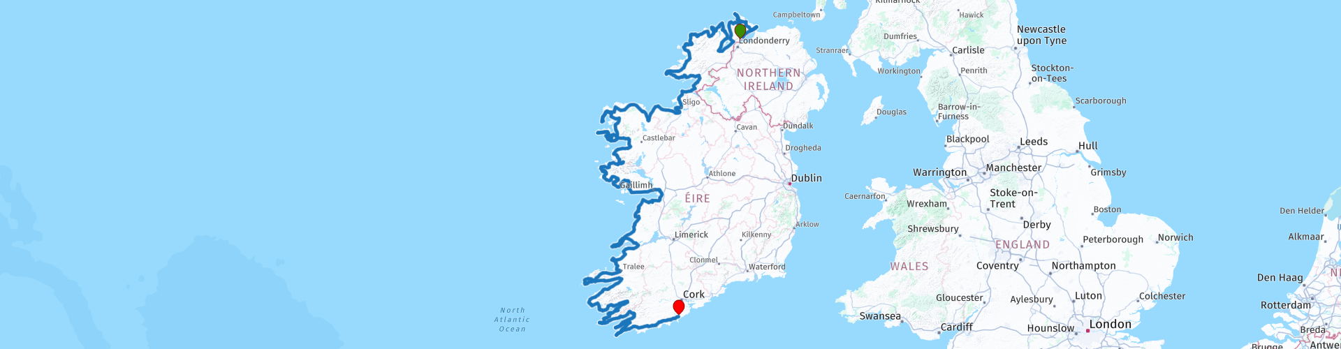
Wild Atlantic Way Muff to Kinsale North to South

This route was brought to you by:
RouteXpert René Plücken (MRA Master)
Last edit: 07-02-2025
 Route Summary
 I have added fuel stops at approximately 245 km or 150 mile intervals. You can choose how many days you want to take and where you want to stay. Below this review you will find links to websites that will provide you with more information about the Wild Atlantic Way, ferry services and general tourist information.
This is Ireland's most iconic route and deserves a 5 star rating. Enjoy.
 Share this route


Animation

Verdict


Duration
49h 24m

Mode of travel
Car or motorcycle

Distance
2,177.83 km

Countries

 RouteXpert Review
 Ireland has many villages and towns with cozy pubs and good restaurants, the inhabitants are very friendly. The route has many winding roads, beautiful hills and mountains, this route is worth 5 stars.
So whether you do the whole route or ride parts of it, exactly as you want, it will be an unforgettable experience. This route runs from North to South but can also be ridden from South to North.
There are many small Irish villages and towns along the way to stop for lunch, dinner or an overnight stay.
Combine the trip with big tours like Ring of Kerry and Ring of Beare. Combine the route with passes like Healy Pass, Conner Pass and Molls Gap.
We used parts of this route for our Ireland trip in 2015. Routes for this route are also on MyRouteXperts (they start with IRL and a number).

 Links
Links  Usage
Usage Want to download this route?
You can download the route for free without MyRoute-app account. To do so, open the route and click 'save as'. Want to edit this route?
No problem, start by opening the route. Follow the tutorial and create your personal MyRoute-app account. After registration, your trial starts automatically.  Disclaimer
Use of this GPS route is at your own expense and risk. The route has been carefully composed and checked by a MyRoute-app accredited RouteXpert for use on TomTom, Garmin and MyRoute-app Navigation.
Changes may nevertheless have occurred due to changed circumstances, road diversions or seasonal closures. We therefore recommend checking each route before use.
Preferably use the route track in your navigation system. More information about the use of MyRoute-app can be found on the website under 'Community' or 'Academy'.

Connacht
About this region
Connacht ( KON-awt, KON-ə(kh)t; Irish: Connacht [ˈkɔn̪ˠəxt̪ˠə] or Cúige Chonnacht [ˌkuːɟə ˈxɔn̪ˠəxt̪ˠ]), or Connaught, is one of the provinces of Ireland, in the west of Ireland. Until the ninth century it consisted of several independent major Gaelic kingdoms (Lúighne, Uí Maine, and Iar Connacht).
Between the reigns of Conchobar mac Taidg Mór (died 882) and his descendant, Aedh mac Ruaidri Ó Conchobair (reigned 1228–33), it became a kingdom under the rule of the Uí Briúin Aí dynasty, whose ruling sept adopted the surname Ua Conchobair. At its greatest extent, it incorporated the often independent Kingdom of Breifne, as well as vassalage from the lordships of western Mide and west Leinster. Two of its greatest kings, Tairrdelbach Ua Conchobair (1088–1156) and his son Ruaidri Ua Conchobair (c. 1115–1198) greatly expanded the kingdom's dominance, so much so that both became Kings of Ireland.
The Kingdom of Connacht collapsed in the 1230s because of civil war within the royal dynasty, which enabled widespread Hiberno-Norman settlement under Richard Mór de Burgh, 1st Baron of Connaught, and his successors. The Norman colony in Connacht shrank from c. 1300 to c. 1360, with events such as the 1307 battle of Ahascragh (see Donnchad Muimnech Ó Cellaigh), the 1316 Second Battle of Athenry and the murder in June 1333 of William Donn de Burgh, 3rd Earl of Ulster, all leading to Gaelic resurgence and colonial withdrawal to towns such as Ballinrobe, Loughrea, Athenry, and Galway. Well into the 16th century, kingdoms such as Uí Maine and Tír Fhíacrach Múaidhe remained beyond English control, while many Norman families such as de Burgh, de Bermingham, de Exeter, de Staunton, became entirely Gaelicised. Only in the late 1500s, during the Tudor conquest of Ireland, was Connacht shired into its present counties.
Connacht's population was 1.4 million before the Great Famine of the 1840s, which began a 120-year decline to under 400,000. The province had a population of 550,000 at the 2016 census.
British cultural imperialism was weaker in the west of Ireland, and Connacht today has the highest number of Irish language speakers among the four Irish provinces. Currently, the total percentage of people who consider themselves as Irish speakers in Connacht is 39.8% (more than 202,000 persons). There are Gaeltacht areas in Counties Galway and Mayo.
The province of Connacht has no official function for local government purposes, but it is an officially recognised subdivision of the Irish state. It is listed on ISO-3166-2 as one of the four provinces of Ireland and "IE-C" is attributed to Connacht as its country sub-division code. Along with counties from other provinces, Connacht lies in the Midlands–North-West constituency for elections to the European Parliament.
Read more on Wikipedia
Between the reigns of Conchobar mac Taidg Mór (died 882) and his descendant, Aedh mac Ruaidri Ó Conchobair (reigned 1228–33), it became a kingdom under the rule of the Uí Briúin Aí dynasty, whose ruling sept adopted the surname Ua Conchobair. At its greatest extent, it incorporated the often independent Kingdom of Breifne, as well as vassalage from the lordships of western Mide and west Leinster. Two of its greatest kings, Tairrdelbach Ua Conchobair (1088–1156) and his son Ruaidri Ua Conchobair (c. 1115–1198) greatly expanded the kingdom's dominance, so much so that both became Kings of Ireland.
The Kingdom of Connacht collapsed in the 1230s because of civil war within the royal dynasty, which enabled widespread Hiberno-Norman settlement under Richard Mór de Burgh, 1st Baron of Connaught, and his successors. The Norman colony in Connacht shrank from c. 1300 to c. 1360, with events such as the 1307 battle of Ahascragh (see Donnchad Muimnech Ó Cellaigh), the 1316 Second Battle of Athenry and the murder in June 1333 of William Donn de Burgh, 3rd Earl of Ulster, all leading to Gaelic resurgence and colonial withdrawal to towns such as Ballinrobe, Loughrea, Athenry, and Galway. Well into the 16th century, kingdoms such as Uí Maine and Tír Fhíacrach Múaidhe remained beyond English control, while many Norman families such as de Burgh, de Bermingham, de Exeter, de Staunton, became entirely Gaelicised. Only in the late 1500s, during the Tudor conquest of Ireland, was Connacht shired into its present counties.
Connacht's population was 1.4 million before the Great Famine of the 1840s, which began a 120-year decline to under 400,000. The province had a population of 550,000 at the 2016 census.
British cultural imperialism was weaker in the west of Ireland, and Connacht today has the highest number of Irish language speakers among the four Irish provinces. Currently, the total percentage of people who consider themselves as Irish speakers in Connacht is 39.8% (more than 202,000 persons). There are Gaeltacht areas in Counties Galway and Mayo.
The province of Connacht has no official function for local government purposes, but it is an officially recognised subdivision of the Irish state. It is listed on ISO-3166-2 as one of the four provinces of Ireland and "IE-C" is attributed to Connacht as its country sub-division code. Along with counties from other provinces, Connacht lies in the Midlands–North-West constituency for elections to the European Parliament.
View region
 Statistics
  10
10Amount of RX reviews (Connacht)
 15099
15099Amount of visitors (Connacht)
 1157
1157Amount of downloads (Connacht)
 Route Collections in this region
 Complete tour of Ireland
Ireland is a beautiful country to drive. This collection contains 10 connecting routes that take you past the most beautiful, cities, villages, sights and wonders of nature.
All routes include reviews, route points for hotels, restaurants and POI.
The Irish population is very friendly and hospitable, in every village there are several pubs and restaurants where you can enjoy Irish cuisine.
There are several (historical) sights included in the routes, here is a summary overview per route, in the reviews of the routes you will find more details.
IRL1; Belvedere House & Garden Parks, Charleville Castle and the Ruins of Clonmacnoise
IRL2; Sky Road, Connemara Natural Park and Kylemoore Abbey.
IRL3; The Burren, the peninsulas Lettermore, Tiermee and Teach Mor, Blackhead and the Cliffs of Moher.
IRL4; Bunratty Castle, Folk Park and King Johns Castle.
IRL5; Ring of Kerry and Skellig Ring, this is without a doubt the most beautiful part of the Ring of Kerry. With a beautiful view of Little Skellig and Skellig Michael, the islands where the latest Star Wars film was shot.
IRL6; Ring of Beare, Glenngariff Woods Nature Reserve and one of the most beautiful panoramas in Ireland: "Ladies View".
IRL7; Killarney National Park with Molls Gap, Ladies View, the Healy Pass and Priest's Leap (very narrow winding route with partly very bad road surface) and Mizen Head.
IRL8; Blarney Castle, Cahir Castle, Killkenny Castle and Saint Canice's Cathedral.
IRL9; Dunmore Caves, SS Dunbrody Irish Emigrants ship, the ruins of Dunbrody Abbey and Garden and Kilkenny Castle.
IRL10; the ruins of the Black Castle, The Altamont Gardens, Powerscourt Gardens and Waterfall and St. Patricks Cathedral.
The routes are mainly country roads, often with beautiful curves, but sometimes very narrow or of poor quality. Driving experience is required, partly because of driving on the left side of the road.
You drive through nature parks and pass such as the Healy Pass, Conner Pass, Priest's Leap and Molls Gap. Two beautiful routes are the famous Ring of Kerry (IRL5) and Ring of Beare (IRL6). These are long journeys with many beautiful things along the way, so staying overnight while on the road is highly recommended. It can also be very busy on these routes in the weekends.
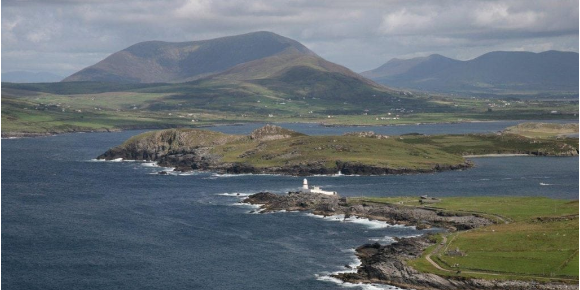
The other two routes in this collection is The Wild Atlantic Way from North-South and from South to North. This route is a sensational journey past towering cliffs and lively villages and towns, past hidden beaches and beautiful bays. This route follows the West Coast and you do multiple places from the other routes. The review of the route contains more details and for even more information I refer to https://www.wildatlanticway.com/home
All routes in this collection are all beautiful and challenging and can be driven by car or motorcycle.
Have fun with these routes.
All routes include reviews, route points for hotels, restaurants and POI.
The Irish population is very friendly and hospitable, in every village there are several pubs and restaurants where you can enjoy Irish cuisine.
There are several (historical) sights included in the routes, here is a summary overview per route, in the reviews of the routes you will find more details.
IRL1; Belvedere House & Garden Parks, Charleville Castle and the Ruins of Clonmacnoise
IRL2; Sky Road, Connemara Natural Park and Kylemoore Abbey.
IRL3; The Burren, the peninsulas Lettermore, Tiermee and Teach Mor, Blackhead and the Cliffs of Moher.
IRL4; Bunratty Castle, Folk Park and King Johns Castle.
IRL5; Ring of Kerry and Skellig Ring, this is without a doubt the most beautiful part of the Ring of Kerry. With a beautiful view of Little Skellig and Skellig Michael, the islands where the latest Star Wars film was shot.
IRL6; Ring of Beare, Glenngariff Woods Nature Reserve and one of the most beautiful panoramas in Ireland: "Ladies View".
IRL7; Killarney National Park with Molls Gap, Ladies View, the Healy Pass and Priest's Leap (very narrow winding route with partly very bad road surface) and Mizen Head.
IRL8; Blarney Castle, Cahir Castle, Killkenny Castle and Saint Canice's Cathedral.
IRL9; Dunmore Caves, SS Dunbrody Irish Emigrants ship, the ruins of Dunbrody Abbey and Garden and Kilkenny Castle.
IRL10; the ruins of the Black Castle, The Altamont Gardens, Powerscourt Gardens and Waterfall and St. Patricks Cathedral.
The routes are mainly country roads, often with beautiful curves, but sometimes very narrow or of poor quality. Driving experience is required, partly because of driving on the left side of the road.
You drive through nature parks and pass such as the Healy Pass, Conner Pass, Priest's Leap and Molls Gap. Two beautiful routes are the famous Ring of Kerry (IRL5) and Ring of Beare (IRL6). These are long journeys with many beautiful things along the way, so staying overnight while on the road is highly recommended. It can also be very busy on these routes in the weekends.
The other two routes in this collection is The Wild Atlantic Way from North-South and from South to North. This route is a sensational journey past towering cliffs and lively villages and towns, past hidden beaches and beautiful bays. This route follows the West Coast and you do multiple places from the other routes. The review of the route contains more details and for even more information I refer to https://www.wildatlanticway.com/home
All routes in this collection are all beautiful and challenging and can be driven by car or motorcycle.
Have fun with these routes.
View Route Collection
7 Beautiful Routes Through Ireland
"7 beautiful routes through Ireland"
You may have seen one of these routes before. There are seven routes driven and created in 2024. The routes are part of a 7-day trip through Ireland. You drive through landscapes that are very diverse. Especially the roads along the coast are breathtaking.
The roads are from reasonable to good, but you also drive on roads that are less maintained and there can be some gravel on the roads here and there. Also, grass often grows in the middle of the roads, so caution is required.
These are generally beautiful routes through a beautiful country. The routes are connecting and go along the west coast. The route starts in Belfast and ends in Rosslare.
The collection contains the following routes:
Day 1 Belfast to Carrick on Shannon via Enniskillen Castle (265 Km)
Day 2 from Carrick on Shannon to Cleggan towards the Wild Atlantic Way (216 Km)
Day 3 from Cleggan to Shannon via The Cliffs of Moher (254 Km)
Day 4 from Shannon to Waterville via the Kerry Cliffs (304 Km)
Day 5 Waterville to Inchigeelagh via Dursey Island Cableway (256 Km)
Day 6 of Inchigeelagh via Mizen Head Tour (214 Km)
Day 7 Inchigeelagh to Rosslare via Hookhead Lighthouse (307 Km)
All routes have been checked and made equal for Tomtom, Garmin, open streetmaps and MyRoute-App Navigation. The routes follow the original route as it was made at the time.
Have fun driving one of these routes. Enjoy all the beauty that Ireland has to offer.
View Route Collection