04 From Carezza al Lago to Lago di Sauris via the Dolomites

This route was brought to you by:
RouteXpert Leonor Orban - Sr. RouteXpert
Last edit: 11-04-2021
 Route Summary
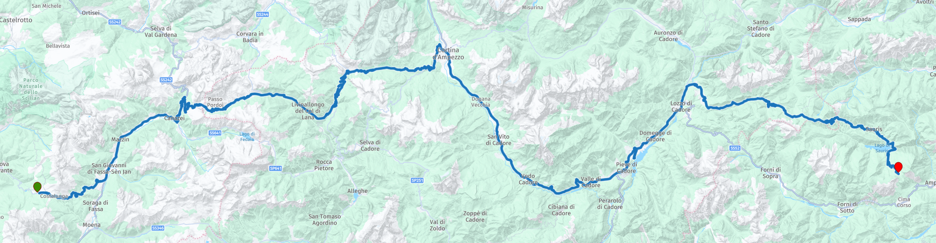
 Today you drive from Carezzo to Lago di Sauris. It is a wonderful ride through one of the most beautiful areas in Northern Italy. It seems a short route with 170 km, but it will definitely be a full-day program with (sometimes narrow) mountain passes and hairpin bends. There is no straight road to be seen today.
The high mountain passes are interspersed with a number of beautiful mountain lakes along the route, where you can take a break and recover from all the bends.
You end the route at Rifugio Alpino Tita Piaz. An attractive mountain hotel, located along the Passo del Pura. In the evening, the view is breathtaking, when the sun sets behind the mountains and it gets really dark.
 Share this route


Animation

Verdict


Duration
4h 14m

Mode of travel
Car or motorcycle

Distance
170.59 km

Countries

 RouteXpert Review
 Hopefully you slept well last night, because the day starts immediately with a wonderfully winding road that demands your full attention: the Karerpass. As soon as you drive out of the village towards the East you can immediately start work. The road winds towards the valley of San Giovanni, where you can refuel if necessary (RP 3).
After a short 45 minute drive, you arrive in the area of the Sella Ronda. Today you only drive the southern part of this famous round: the Passo Pordoi (RP 5). Keep a close eye on which day you want to drive over this mountain pass. In recent years, the Sella Ronda has been closed to motorized traffic on Wednesdays. Before leaving at Hotel Alpenrose, first ask what the status is and whether you can use the pass. If the pass is closed, you can follow the SP641 from RP 4 to Lago / Passo di Fedaia, Col di Rocca and finally Cernadoi. From here you can continue the route.
If the pass is open, it is an absolute must to get off the bike a little earlier than usual. At the highest point of the Passo Pordoi (RP 5) you can park and take the funivia to Sasso Pordoi at 2,950 meters. On top of this mountain top is a Rifugio. It is not without reason that the terrace of this break point is called “the terrace of the Dolomites”: you can enjoy a spectacular view of the Sella Ronda and the surrounding mountains in the Dolomites.
As soon as you pick up the route again, the road winds further to the Northeast. The Passo Pordoi gives you a number of hairpin bends to play and to further sharpen your driving technique. You will catch your breath as you drive through the valley, but from Cernadoi the route shows you again how beautiful driving is in the Dolomites. The area you are in now used to be a busy route for through traffic. Castello Andraz (RP 6) symbolizes this. The castle already existed in the Middle Ages and, together with a number of other castles, controlled and controlled the flow of traffic between Agordina and Val Pusteria. Nowadays your journey is much smoother and the castle can be visited without consequences: at most a small contribution for access to the castle. Keep in mind that in principle you can drive up to the castle and park there (briefly), but the last part of the road is unpaved.
It is time again to conquer some beautiful mountain passes. First you come across the Passo Falzarego. This mountain pass offers stunning views of surrounding mountains such as the Marmolada and Cinque Torri along the way. Don't forget to stop every now and then and take a picture (for example RP 9)! Of course you can take a break on this route. The Locanda Del Cantoniere (RP 8) is a great coffee stop. It is less touristy and less crowded here than at the break points at the highest point of the pass (RP 7).
The Passo Falzarego eventually leads you to Cortina d'Ampezzo, the largest town in the Dolomites and a popular ski resort.
About 50 minutes drive, from Cortina d'Ampezzo, the route leads you to Chalet Lagole at Lago di Cadore (Lake Cadore). Pay attention to this as TomTom and Garmin do not give equal instructions. After you enter the village of Calalzo di Cadore, the route asks you to turn right. Look carefully at the road in front of you and any signs that indicate Lago di Cadore / Chalet Lagole. It is best to follow these signs. Especially if you drive with a TomTom: it indicates a route that will eventually get you stuck. Tip for TomTom: keep left after RP 13 and make sure that all train tracks remain to your right. Eventually you will arrive at the lake and you can enjoy a walk, a swim or a break at Chalet Lagole. It's definitely worth the search!
Eventually you will get to the last part of the route. It is true that you are not a kilometer-eater as a route today, but the roads also make it challenging to cover a great distance. This certainly applies to the last part. At RP 17 (Agip) you can refuel for a while, after which a number of spicy and challenging mountain passes follow. The Sella Ciampigotto, Sella Razzo and Sella Rioda are a quiet alternative to the heavy traffic on the SS52 between Lorenzago di Cadore and Ampezzo. This is because the SS52 is a lot easier to ride than the 3 previously mentioned Sella's. You can enjoy the (hairpin) bends in peace and on the way you can also stop at Lago di Sauris for some photos. The dam at this reservoir was built in World War II by captured New Zealand soldiers. The reservoir behind the dam was finally filled in 1948, after the inhabitants and the church of the village of La Maina moved to higher-lying villages in the area. The remains of the village have been visible twice more in recent decades, after the reservoir was emptied to carry out maintenance work on the dam.
After this photo stop, you will enter a number of narrow tunnels along the reservoir. If all goes well, lighting has been installed in the tunnel in recent years, so that you have (slightly) more visibility. Keep in mind that the road surface in the tunnels can be slippery due to condensation!
Before you arrive at your end point today (Rifugio Alpino Tita Piaz) you drive a part of the Passo del Pura to finish off hopefully a beautiful day. If you really haven't had enough and / or if you arrived early at the end point, you can still drive around in the Sauris region. Val Lumiei is worth it and for the endurists among us: this area is known for a number of beautiful unpaved and accessible mountain passes. For the various options you can visit the website of Alpenrouten. This gives an overview of the various passes (including difficulty, quality road surface, etc.)
Please note that today's route has a number of mountain passes, which may be experienced by some as technically challenging. The three Sella's at the end of the route, including the Passo de l Pura, can be particularly tough. If you have any doubts about your own skills, consider deviating from the route at Lozzo di Cadore and following the SS52 to Ampezzo. There are plenty of accommodation options in this area. From here you can also easily pick up the next day trip and continue the route of the holiday.
This route gets 5 stars from me. It is a beautiful Domolite ride, with not the least of passes. The Karer Pass, Passo Pordoi, Passo Falzarego all pass by (to name a few). From start to finish, enjoy one hairpin after the other. You meander through beautiful valleys, over high peaks. And along the way you can enjoy beautiful break places, such as Chalet Lagole. The views are enchanting and the roads meander endlessly.
Have Fun (with a capital P)!
Note:
Between RP 13 and RP 14 the routes on TomTom and Garmin are not the same. Follow the Garmin instructions on this part. If you only use TomTom navigation: keep left at the y-junction after RP13 and follow the directions for Lago di Cadore. After RP 14 the routes are the same again.


 Links
Links  Usage
Usage Want to download this route?
You can download the route for free without MyRoute-app account. To do so, open the route and click 'save as'. Want to edit this route?
No problem, start by opening the route. Follow the tutorial and create your personal MyRoute-app account. After registration, your trial starts automatically.  Disclaimer
Use of this GPS route is at your own expense and risk. The route has been carefully composed and checked by a MyRoute-app accredited RouteXpert for use on TomTom, Garmin and MyRoute-app Navigation.
Changes may nevertheless have occurred due to changed circumstances, road diversions or seasonal closures. We therefore recommend checking each route before use.
Preferably use the route track in your navigation system. More information about the use of MyRoute-app can be found on the website under 'Community' or 'Academy'.

Trentino-Alto Adige/Südtirol
About this region
Trentino-Alto Adige/Südtirol (US: , UK: ; Italian: Trentino-Alto Adige [trenˈtiːno ˈalto ˈaːdidʒe]; German: Trentino-Südtirol; Ladin: Trentin-Südtirol) is an autonomous region of Italy, located in the northern part of the country. The region has a population of 1.1 million, of whom 62% speak Italian as their mother tongue, 30% speak German dialects and several foreign languages are spoken by immigrant communities. Since the 1970s, most legislative and administrative powers have been transferred to the two self-governing provinces that make up the region: the Province of Trento, commonly known as Trentino, and the Province of Bolzano, commonly known as South Tyrol (Alto Adige in Italian).
From the 9th century until 1801, the region was part of the Holy Roman Empire. After being part of the short-lived Napoleonic Republic of Italy and Napoleonic Kingdom of Italy, the region was part of the Austrian Empire and its successor Austria-Hungary from 1815 until its 1919 transfer to Italy in the Treaty of Saint-Germain-en-Laye at the end of World War I. Together with the Austrian state of Tyrol it is represented by the Euroregion Tyrol-South Tyrol-Trentino.
In English, the region is known as Trentino-South Tyrol or by its Italian name Trentino-Alto Adige.
Read more on Wikipedia
From the 9th century until 1801, the region was part of the Holy Roman Empire. After being part of the short-lived Napoleonic Republic of Italy and Napoleonic Kingdom of Italy, the region was part of the Austrian Empire and its successor Austria-Hungary from 1815 until its 1919 transfer to Italy in the Treaty of Saint-Germain-en-Laye at the end of World War I. Together with the Austrian state of Tyrol it is represented by the Euroregion Tyrol-South Tyrol-Trentino.
In English, the region is known as Trentino-South Tyrol or by its Italian name Trentino-Alto Adige.
View region
 Statistics
  53
53Amount of RX reviews (Trentino-Alto Adige/Südtirol)
 37836
37836Amount of visitors (Trentino-Alto Adige/Südtirol)
 7759
7759Amount of downloads (Trentino-Alto Adige/Südtirol)
 Route Collections in this region
 The 24 Most Beautiful Alpine Routes
The Alps, The Alps are a mountain range in Europe, stretching from the French Mediterranean coast in the southwest to the Pannonian Plain in the east. The area of the mountain range is more than 200,000 km².
In other words Passes and Mountain Roads!
Driving through the mountains is great! Especially over the mountain passes with hairpin bends and narrow winding roads. Every bend a different view where you can enjoy. There are many beautiful mountain passes in the Alps.
A selection that has also been incorporated into these routes:
The Stlevio Pass:
The Stelvio Pass, also known as Passo dello Stelvio, is mainly known for the stage in the Giro d'Italia. Due to the length and the difference in height, this pass is seen as one of the toughest tests in cycling. The Stelvio Pass reaches a maximum height of 2758 meters and is therefore one of the highest in the Alps. The pass connects the towns of Bormio and Prato Allo Stelvio. In winter the pass is closed due to heavy snowfall.
The Reschenpass:
The Reschenpass, also known as Passo di Resia, connects the Austrian state of Tyrol with the Italian province of South Tyrol. The pass reaches a maximum height of 1,504 meters and has been one of the most important north-south connections in the Alps in recent centuries. The pass was used long before Roman times. Along the way you will pass several highlights and historical relics. One of the highlights is the Reschensee. This lake was created after the construction of the dam and has completely submerged the village of Graun. The only thing that reminds of that is the clock tower in the middle of the lake.
Col du Galibier:
The French mountain pass Col du Galibier connects the towns of Saint-Michel-de-Maurienne and Briançon via the Col du Lautaret in the south and the Col du Télégraphe in the north. The mountain pass is part of the Tour de France and very much feared, due to the fact that it can only be reached via the other two mountain passes. The pass reaches a maximum height of 2646 meters. From there you can take a walk to the viewpoint at 2704 meters. You can admire the peaks of the Grand Galibier, Mont Blanc and La Meije here.
The Grossglockner High Alpine Road:
With a height of 3798 meters the Grossglockner is the highest mountain in Austria. To fully enjoy this impressive mountain, you can drive over the Grossglockner High Alpine Road and the accompanying pass. The route starts from Bruck am Grossglockner and ends in Heiligenblut. Of course you can drive in two directions. The pass reaches a maximum height of 2504 meters and is closed in winter due to heavy snowfall. Along the way you pass several stops with fun activities, information points, mountain huts and viewpoints. A visit to the Kaiser-Franz-Josefs-Höhe and Pasterzen Glacier is highly recommended.
The Col d'Izoard:
Just like the Col du Galibier, the Col d'Izoard is also part of a stage of the Tour de France. The mountain pass connects Briançon with the valley of the river Guil. The pass is partly located in the Regional Natural Park du Queyras and reaches a maximum height of 2360 meters. What is special about the Col d'Izoard is the barren and rocky landscape. Sometimes it feels like driving a car over the moon! Along the way you can stop at several points to enjoy the beautiful view.
The Bernina Pass:
The Bernina Express is one of the most famous rail trains in Switzerland and the Alps. The route is beautiful and partly included on the UNESCO World Heritage List. Parallel to the railway lies the Bernina pass, which connects the Veltlin valley with the Egandin valley. This beautiful Alpine road has a total length of 56 kilometers and reaches a maximum height of 2328 meters. Along the way you can enjoy views of the Morteratsch Glacier.
The Sella Pass:
The Sella Pass, also known as Passo di Sella, takes you over one of the most impressive mountain ranges in the Dolomites: the Sella massif. The pass connects Valle di Fassa with Val Gardena and reaches a maximum height of 2236 meters. At this height is also the border of the Italian provinces of Trentino and Bolzano. Along the way you can enjoy the view of this spectacular mountain world. Admire, for example, the three peaks of the Sasso Lungo massif, the Sella massif or the peaks of the Marmolada. You can also drive the Sella pass in combination with the Gardena pass, Pordoi pass and Campolongo pass.
The Grimsel Pass:
The Grimsel Pass connects Goms in Wallis with the Halis Valley in the Bernese Oberland. The pass reaches a maximum elevation of 2165 meters and is closed in winter due to snowfall. Over the centuries, the mountain pass has played an important role in trade between Switzerland and Italy. Now it is mainly the reservoirs that have an important function. These are used to generate electricity. The landscape you drive through is rugged, rocky and impressive. On top of the pass is a hotel and a restaurant with a special marmot park. The Dodensee (Totensee) is also located here. This lake owes its name to the many soldiers who died in the time of Napoleon.
The Gotthard Pass:
The Gotthard Pass, also known as Passo del San Gottardo and Saint Gotthard, connects the Swiss towns of Airolo and Andermatt. The mountain pass and associated tunnel are especially known among holidaymakers driving from Switzerland to Italy. But where the majority opt for the tunnel, it is precisely the pass that really completes the holiday. The Gotthard Pass has a length of about 26 kilometers and reaches a maximum height of 2106 meters. The route is beautiful and takes you along old villages and beautiful views.
The Silvretta High Alpine Road and Silvretta Pass:
The Paznaun Valley in Tyrol and the Montafon in Vorarlberg are connected by the Silvretta High Alpine Road. The route has a length of 22.3 kilometers and leads from Galtür to Partenen in 34 hairpin bends, via the 2032 meter high Bielerhöhe. The Silvrettasee is also located at this point, where you can enjoy a lovely walk. The pass is closed in winter due to snowfall.
The Simplon Pass:
Just like the Gotthard Pass, many holidaymakers also travel over the Simplon Pass every year. This mountain pass connects the Rhone Valley in the canton of Valais with the Valle d'Ossola in Piemonte. The pass is open all year round and reaches a maximum height of 2005 meters. Along the way you pass a number of buildings, including the well-known Simplon Hospiz from 1825. The hospiz is managed by the monks of St. Bernard. From the highest point on the pass, all kinds of hiking routes are possible and you will also come across a hotel where you can spend the night.
The Gerlos Pass:
The Gerlos Pass connects the Salzach Valley in the Salzburgerland with the Zillertal Valley in Tyrol. The pass is part of the Gerlos Alpenstraße and runs right through the Hohe Tauern National Park. Along the way you can enjoy beautiful views of the surroundings. The pass has a length of 12 kilometers and reaches a maximum height of 1531 meters. A ride over the Gerlos Pass can be ideally combined with a visit to the Krimmler Wasserfälle.
The Great St. Bernard Pass:
The Great St. Bernard Pass, better known as Col du Grand Saint Bernard, connects the Italian province of Valle d'Aosta with the Swiss canton of Valais. The pass is one of the highest in Switzerland and reaches a maximum height of 2469 meters. Like a number of other mountain passes in this list, the Great St. Bernard Pass has also been used as a connecting road for centuries. The pass is named after the St. Bernard dogs that used to help stranded travelers along with the monks. The pass is closed in winter.
The Timmelsjoch High Alpine Road:
The Timmelsjoch High Alpine Road connects the towns of Sölden in the Ötztal and Meran in South Tyrol. Tolls must be paid on the Hochgurgl - Moos route. Via a mountain road with about 60 hairpin bends you drive through a beautiful mountain world. With the Timmelsjoch Experience you can learn more about the history, the road and the environment via various stations. You can also visit the Top Mountain Crosspoint museum.
Col de l'Iseran:
With a maximum pass height of 2770 meters, the Col l'Iséran is one of the highest mountain passes in the Alps. The pass connects Bourg-Saint-Maurice with Bonneval-sur-Arc. Via a road full of hairpin bends you pass, among other things, Val-d'Isère and a side valley of the Maurienne that lies entirely in the National Park de la Vanoise. You can spot animals such as marmots and chamois and there is also a restaurant with a chapel on top of the pass.
The Gavia Pass:
The Gavia Pass (Italian Passo di Gavia) is a mountain pass in the Italian Alps, in the Lombardy region.
It is one of the highest pass roads in Europe. The road leads through the unspoilt Stelvio National Park. The road was built in the First World War to supply Italian soldiers who fought in the Italian-Austrian border area. The pass height is one of the most beautiful in the Alps. Here is the large Lago Bianco with, to the north, the mountain San Matteo (3684 meters). Lago Nero is slightly lower on the south side of the pass. Here the mountain group of the Adamello determines the view. There are many well-marked walks in the area. During the winter the pass is closed due to the heavy snowfall. The pass is often closed until May and June due to the large amount of snow.
Promoter has made a selection of the 24 Most Beautiful Alpine routes that they have set out in recent years.
The routes go through:
France
Austria
Switzerland
Italy
The most beautiful roads, the most beautiful views, the most beautiful viewpoints. The highest mountains, the fastest descents, hairpin bend after hairpin bend, you name it you can't get enough of it.
If you go on holiday in this region, take advantage of it, ALL routes in this collection have been checked and made equal for TomTom, Garmin and MyRoute-app Navigation by a MyRoute-app RouteXpert.
Have fun with this collection and while driving one of these routes. Enjoy all the beauty that the Alps and the Dolomites have to offer. Click on “View route” to read the review of the chosen route.
I would like to hear your findings about the route(s).
View Route Collection
The 8 most beautiful routes of the Dolomites
The Dolomites are a mountain range in Italy that is part of the Southern Limestone Alps. Typical for the Dolomites are the steep rock walls and peaks, which were created by erosion and weathering. The mountain range is split into two parts: the eastern and the western. The highest peak of the Dolomites, the Marmolada, is 3343 meters high.
Enjoy the beautiful routes in the vicinity of the Marmolada. Whichever way you drive in the Dolomites, it is always fantastically beautiful. You get one (toll-free) pass after the other for your wheels and it is pure enjoyment every time. A wonderful playground that changes depending on the hour, depending on the direction, depending on the weather and which completely enchants you!
The routes have been checked and made equal for Garmin, TomTom and MyRoute-app Navigation users. Do you have a fantastic route in the Dolomites that belongs in this list? Send us the route via routeexpert@myrouteapp.com.
Enjoy!
View Route Collection