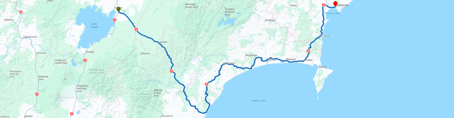
12 Taupo to Gisborne

This route was brought to you by:
RouteXpert Nick Carthew - (MRA Master)
Last edit: 26-03-2021
 Route Summary
  Share this route


Animation

Verdict


Duration
6h 12m

Mode of travel
Car or motorcycle

Distance
323.65 km

Countries

 RouteXpert Review
 The landscape is quite flat and heavily forested until you reach the regional border from Bay of Plenty to Hawk's Bay at RP 4. The road becomes more twisty and you are surrounded by hills. The magnificent Waiarua Falls and Waipunga Falls can be viewed from a car park at RP 5 and are well worth a short stop for a photo. Next stop is at RP 6 for a coffee break at Tarawera Cafe. This is a popular spot with travellers stopping in for refreshments or comfort stop.
The Thermal Explorer Highway is shown on the Michelin map with a green with a green line running alongside it. For the uninitiated, the green line represents a scenic route and this road doesn't disappoint. As you approach the South Pacific Ocean and follow the River Esk to Eskdale you will see many vineyards, wineries and orchards alongside the road. Chardonnay and red wine grapes are grown in the Esk River valley.
Now the route joins the Pacific Coast Highway and travels in a north-easterly direction briefly running directly alongside the ocean before heading back inland through wooded valleys on an undulating and twisty road. RP 12 offers you the chance to relax for a while on the shores of Lake Tutira, a wildlife refuge that's popular for camping and picnics. Memorable for its weeping willows and prolific bird life, the lake was declared a bird sanctuary in 1929 at the instigation of Scottish farmer/author/ornithologist William Herbert Guthrie-Smith.
At RP 14 you will pass under the Mohaka Viaduct, a railway viaduct spanning the Mohaka River. It was built between 1930 and 1937 by the Public Works Department for the New Zealand Railways Department. It is 276.8 metres in length, and at 95 m it is the tallest viaduct in the whole of Australasia. It carries the Palmerston North - Gisborne line that stays near to the this route.
I've suggested a lunch stop at RP 16, at the 2ate7 Cafe. They serve a good selection of food all freshly cooked. Alternatively, you can carry on to the town of Wairoa just 3 kms further along the route. I have suggested a fuel stop at Wairoa. Lookout for the old wooden lighthouse on the right just before you cross the Wairoa River. The Wairoa Lighthouse was originally built on Portland Island off the Mahia Peninsula, and was one of the earliest lighthouse sites in New Zealand.
Built from solid Kauri wood, it was in use from 1878 to 1960. It was moved to its current site beside the Wairoa river in 1960, following the introduction of an automated lighting system at Portland Island.
In 2016, local resident Richard Lynch embarked on a project to repaint the top of the lighthouse, and was amazed to find that beneath the coats of paint that had been applied over the years was a pristine copper dome.
You can see the Mahia Peninsula just after passing the Whakaki Lagoon at RP 19.
There are some hot springs 3 kms after you cross the Nuhaka River at RP 20. The Morere Springs are clearly signposted and worth visiting if you have time, the end of the route at Gisborne is just 45 minutes away.
The Morere Springs are a treat not to be missed – gorgeous hot and cold springs set amid 364 hectares of rainforest. Rare in the world of hot springs, the Morere Springs produce 250,000 litres a day of hot ancient sea water. Known for its therapeutic values, the water is piped to a series of public and private hot pools. It is definitely worth taking a walk on any of the various walks in the Morere Scenic Reserve, from 10-minute walks up to three hours. Especially famous for its nikau palms, the dense virgin rainforest is home to a wide range of native birds.
Cross over the regional border from Hawk's Bay to Gisborne, and before you know it you will have arrived at your destination.
Gisborne:
Gisborne is the first city in the world to greet the sun each morning, and it has a reputation for great food, wine and surf beaches. As the unofficial ‘Chardonnay Capital of New Zealand’, Gisborne has a comprehensive wine trail leading to boutique wineries.
Kaiti Beach is the site of Captain Cook’s first landing in New Zealand (9 October 1769); nearby is the historic Te Poho O Rawiri Marae, located on the corner of Ranfurly Street and Queens Drive. A Marae is a communal or sacred place that serves religious and social purposes in Polynesian societies. This was the first marae in this area and was established in 1852, near the site of the Gisborne wharf and later the harbour basin. If you’re interested in Māori culture, Gisborne is an essential port of call on your itinerary – old traditions are still evident in many parts of the city. Oral history records Titirangi (Kaiti) Hill as the point of arrival for the migratory waka (canoe), Horouta, which brought the first Māori to the area.
There is a statue of Captain Cook and Young Nick standing by the entrance to the harbour.
Nicholas Young (born c. 1757) was a British cabin boy aboard the Endeavor during Captain James Cook's first voyage of discovery. In 1769, Cook named the headland Young Nick's Head in Poverty Bay, New Zealand after him.
Young was eleven years old when the Endeavor departed Plymouth, England on 26 August 1768. He was the personal servant of the Endeavor’s surgeon, William Brougham Monkhouse. In early October 1769, Cook offered a reward of rum to the man who first sighted land, and promised that 'that part of the coast of the said land should be named after him'. This was awarded to Young who first sighted land from the masthead at about 2pm on 6 October 1769.
I have ended this route at the McDonald's in Gisborne to give you a chance to unwind before finding you accomodation. I have suggest several differing types of accommodation below in the links, but as is with all popular towns and cities the choice is vast.
The next route of this tour gives you a choice: Route 13a Gisborne to Opotiki Coastal Route. This travels around the coast of the Raukumara Peninsula offering stunning coastal views and is about 323 kms.
Or Route 13 b Gisborne to Opotiki through the Waioeka Gorge Scenic Reserve. This is a much shorter route at only 140 kms but the inland scenery through the gorge is beautiful, the choice is yours, A or B they both finish at Opotiki.
Enjoy.


 Links
Links  Usage
Usage Want to download this route?
You can download the route for free without MyRoute-app account. To do so, open the route and click 'save as'. Want to edit this route?
No problem, start by opening the route. Follow the tutorial and create your personal MyRoute-app account. After registration, your trial starts automatically.  Disclaimer
Use of this GPS route is at your own expense and risk. The route has been carefully composed and checked by a MyRoute-app accredited RouteXpert for use on TomTom, Garmin and MyRoute-app Navigation.
Changes may nevertheless have occurred due to changed circumstances, road diversions or seasonal closures. We therefore recommend checking each route before use.
Preferably use the route track in your navigation system. More information about the use of MyRoute-app can be found on the website under 'Community' or 'Academy'.