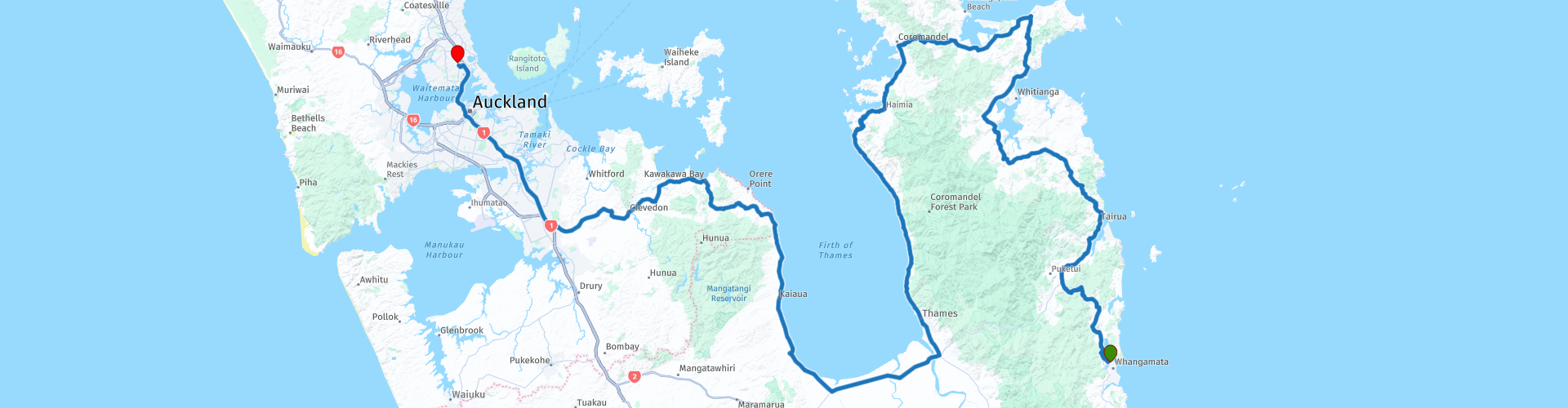
15 Whangamata to Auckland

This route was brought to you by:
RouteXpert Nick Carthew - (MRA Master)
Last edit: 26-02-2021
 Route Summary
 The route travels through natural forests and follows the shore of the Firth of Thames. Excellent landscapes, very good roads and good attractions earn this route 4**** stars.
 Share this route


Animation

Verdict


Duration
8h 4m

Mode of travel
Car or motorcycle

Distance
307.80 km

Countries

 RouteXpert Review
 The Coromandel is renowned for its pristine beaches, misty forests and laid-back vibe and is one of New Zealand's most popular holiday destinations for Kiwis.
Talking about Kiwis, this time the flightless, endemic bird that New Zealanders take their loving nickname from.
At RP 5, the Whenuakite Kiwi Recovery Area, you can visit a viewpoint and read about the work going on to help these cute birds and have a great view out to sea at the same time. Since 2000, the Whenuakite Kiwi Care Group has looked after the Whenuakite Kiwi Recovery Area, a patch of regenerating coastal broadleaf and kauri forest lying between Tairua and Hot Water Beach.
You can visit Hot Water Beach by turning off at RP 6, it's a 10 minute ride. Within two hours either side of low tide visitors flock to the usually deserted Hot Water Beach to find hot water bubbling through the golden sand. Families, kids and couples can be seen digging their own spa pool in the sand and relaxing in the natural springs. Often rated as one of the world's most renowned beaches - this is one experience that should be on your bucket list.
First coffee stop of the day is at RP 9 on the banks of the Kuaotunu River. Enjoy the laid back vibes that Kuaotunu has to offer.
From here the route heads west, cutting off the top of the peninsular and heading towards the Firth of Thames.
The Firth of Thames is a large shallow bay that is an important wildlife habitat. At it's southern end the mudflats host many different species of migratory birds, but more of that later.
The road that hugs the shoreline of the firth is known locally as the Thames Coast road (firth is a word in the English language used to denote various coastal waters in the United Kingdom). The road is 34 kms long from where you join it to the coastal town of Thames. The town was initially built during a gold rush, with the first major discovery of gold being made on 10 August 1867 by William Hunt, in the Kuranui Stream at the north end of Thames. The subsequent mine produced more than 102,353oz (2900 kg) of bullion and was known as the Shotover.
At RP 17, you can visit the Goldmine Experience. The Goldmine Experience is a unique and hands-on way to discover a whole lot of mining history, chemistry, mineralogy, power generation and all the other skills and knowledge used by early pioneers in the search of fortune. Allow at least 40 minutes for your visit. The tour underground can be muddy, especially during the wetter months. Bring closed-toe footwear and a waterproof jacket just in case, your own torch if you have one, and plenty of luck in your quest for gold, you may leave with a nugget that you panned!
Thames is also where I have suggested a lunch stop and refuel, There is a fuel station with a Kentucky Fried Chicken outlet opposite, or venture into town for a good selection of cafes and restaurants.
You are now at the southern end of the firth where thousands of wading birds visit annually. The mudflats, shell banks, grass flats, saltmarsh and mangrove forest form one of the three most important coastal areas for shorebirds in New Zealand. The skies above the shallow estuarine waters of the firth are often flecked with flocks of migratory birds on the wing.
The route now travels up the eastern shore of the firth to Kawakawa Bay, you can either stop here for a coffee or spend the last night of the tour here. There is a very welcoming motel on the seafront in this laid back small town. Auckland is just a one hour ride away. 30 minutes through farmland and 30 minutes of motorway. Interestingly, when viewed on the Michelin Map this entire route uses roads that have a green line running alongside them, even the motorway. For the uninitiated, the green line represents a scenic route.
Although there are 15 routes in this tour, routes 13a and 13b offer you an alternative route so the number of days traveling is 14. I would allow 3 weeks for this tour allowing you to spend 2 or maybe 3 nights at different locations, these might include:
Paihia. An excellent base from which to explore the Bay of Islands.
Raglan. Both a surfing mecca and a dramatically scenic area of black sandy coastline.
City of Wellington. Recently named "the coolest little capital in the world" by Lonely Planet.
Napier. Beautifully preserved 1930s architecture is Napier's special point of difference.
Rotorua. Known for bubbling mud pools, shooting geysers and natural hot springs, and Māori culture.
Enjoy.


 Links
Links  Usage
Usage Want to download this route?
You can download the route for free without MyRoute-app account. To do so, open the route and click 'save as'. Want to edit this route?
No problem, start by opening the route. Follow the tutorial and create your personal MyRoute-app account. After registration, your trial starts automatically.  Disclaimer
Use of this GPS route is at your own expense and risk. The route has been carefully composed and checked by a MyRoute-app accredited RouteXpert for use on TomTom, Garmin and MyRoute-app Navigation.
Changes may nevertheless have occurred due to changed circumstances, road diversions or seasonal closures. We therefore recommend checking each route before use.
Preferably use the route track in your navigation system. More information about the use of MyRoute-app can be found on the website under 'Community' or 'Academy'.