D06 Indianola Natchez

This route was brought to you by:
RouteXpert Hans van de Ven (Mr.MRA)
Last edit: 17-11-2019
 Route Summary
 The roads are good and the views are beautiful, although you sometimes have to search for them along the Mississippi.
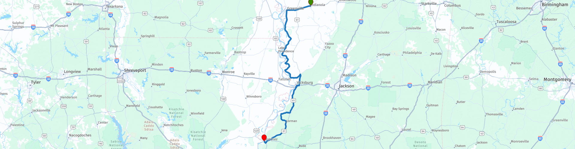
Starting point: Quality Inn Indianola.
End point: Hotel Vue, Natchez
The route has been made the same for TomTom, Garmin and MyRoute-app Navigation users.
Thanks to Richard & Lisa for the information!
 Share this route


Animation

Verdict


Duration
5h 8m

Mode of travel
Car or motorcycle

Distance
355.54 km

Countries

 RouteXpert Review
 We continue on Route 1 South, in the direction of Vicksburg. The road follows the Mississippi, although you do not always see it, but just search, and you will find a beautiful landscape. About 30 kilometers before that city, you will return to Route 61. Vicksburg is situated on a high, steep cliff in a bend of the Mississippi, strategically located because you control both the northern and southern river courses from there. You will get a grip on the very unique character of the city,
especially as you learn more about Vicksburg's role in the Civil War. Sometimes it seems as if the war ended yesterday instead of 130 years ago. Vicksburg was called the Gibraltar of the Confederacy (of the Southern States) before the city had to surrender to the Northern in 1863, after a long and bitter siege.
So long and so bitter that Vicksburg has a bit of a symbolic function in the South. The battlefield near the city is a collection of monuments on well-kept green meadows, but as always the park service has set up excellent exhibitions that explain how the battle went about.
In Vicksburg itself the small local museum is recommended. It tells a lot about daily life in the besieged city and the misery after the surrender. Despite the bombing, there are also large pre-war country houses, such as Balfour House and Martha Vick House. Let a guide guide you through Vicksburg National Military Park by booking a tour.
Another way to take a look at the city is by taking a boat tour with the Spirit of Vicksburg, a somewhat smaller paddle boat. He leaves at the foot of Clay Street, at the bottom of the cliff. Vicksburg National Military Park, 3201 Clay Street, on Route 20, open from 8-5.
From Vicksburg you follow Route 61 South or the smaller roads that lead to the Mississippi. Via Port Gibson, where there are already eight churches on Church Street alone! The Windsor Ruins are also located in Port Gibson, this was a large plantation house from 1861 of which only the massive pillars are still standing. The route to Natchez is picturesque on the Mississippi, or rather on the high banks of the river with a wealth of memories of the long-lost and romanticized glory times of the Old South. Natchez is the oldest settlement on the Mississippi and still shows the prosperity in which the plantation owners and other wealthy people lived before the Civil War. Natchez is also the end (or the beginning!) Of the Natchez Trace Parkway.
The city has no fewer than five hundred so-called ante-bellum (as is mentioned here before the Civil War) buildings, including many homes of rich southerners in particular. Before the Civil War, it is said, half of all American millionaires lived in Natchez, and they built huge houses. During the Civil War the city was spared, so that most of the houses are still there as in their heyday. A number of houses can be visited and regularly there are costumes in which people pretend that the Civil War never took place, the so-called Natchez Pilgrimage. A special case is Longwood, according to many one of the most fascinating houses in America - all the more since it was never finished after construction was stopped during the Civil War. The gigantic house has an octagonal shape, with Moorish columns and arches on all sides. On top of the tower structure is an onion-shaped roof. The beautiful house is now owned by the Pelgrimage Garden Club and worth a detour.
Natchez-Under-the-Hill is where the boats that sailed the Mississippi moored. It was a famous gathering place for thieves, scammers, gamblers and prostitutes. Many shipmen who returned from New Orleans to go home, to the North, lost their hard-earned money here. Her nickname was Sodom-of-the-Mississippi. Now it is a tourist spot, where the luxury paddle boats, the Mississippi Queen and the Delta Queen are still mooring. One can also make a short tour with the Jubilee, a tour boat.
In this 4-star route you will drive along beautiful good roads, where you definitely have to make a longer stop in Vicksburg, and you will also stop regularly to take some pictures in this route.
History:
Before the construction of a French settlement called 'Fort Rosalie' in 1716, the Natchezindians lived in this area. Because the soil of Mississippi turned out to be very fertile, Natchez quickly became a major producer of cotton. Fortunes were earned because they benefited from slave labor. The cotton was transported to Europe by ship. After a number of small rebellions, the Natchezindians, together with the tribes of the Chickasaw and Yazoo, organized a war against the French rulers. The 'Natchez War' or 'Natchez Massacre' took place in November 1729. The entire French settlement in Natchez was destroyed, as well as other settlements in the area. At the end of the month, more than two hundred French were killed. In the two years that followed, the French and their Indian allies struck back: the majority of Natchezindians in the region lost their lives. When the Indian leader surrendered, the living Indians were transported by order of the French Prime Minister to New Orleans and sold as a slave.
The village that originated around Fort Rosalie, retained the name of the Indians (Natchez) and it remained inhabited. From 1763, Natchez was under British rule, but from 1779 to 1798 the Spaniards took over temporarily. After that, Natchez became the capital of the new Mississippi Territory. In 1817, Mississippi became a state of which Natchez did not remain the capital: in 1822, Jackson became the new capital. The state attracted many new residents, who centered in the north and east. The west, in which Natchez lay, was no longer the central part and therefore not a good place for a capital.
That Natchez used to be a thriving center can be seen on the Natchez Trace Parkway, the historic trade route that once ran from New Orleans to Nashville. This route was used by the Indians and later also by the traders. For the latter group, the road was not always without danger because the Natchez Trace ran across the land of the Choctaw and Chickasawindians. With the introduction of the steamboat at the start of the nineteenth century, the path lost its function. Today you will find beautiful hiking trails, sights (burial mounds, battlefields from the Civil War, etc.) and campsites.


 Links
Links  Usage
Usage Want to download this route?
You can download the route for free without MyRoute-app account. To do so, open the route and click 'save as'. Want to edit this route?
No problem, start by opening the route. Follow the tutorial and create your personal MyRoute-app account. After registration, your trial starts automatically.  Disclaimer
Use of this GPS route is at your own expense and risk. The route has been carefully composed and checked by a MyRoute-app accredited RouteXpert for use on TomTom, Garmin and MyRoute-app Navigation.
Changes may nevertheless have occurred due to changed circumstances, road diversions or seasonal closures. We therefore recommend checking each route before use.
Preferably use the route track in your navigation system. More information about the use of MyRoute-app can be found on the website under 'Community' or 'Academy'.


1 / 1

