Mid Tennessee Roundtrip from Crossville to Devils Triangle to Byrdstown

This route was brought to you by:
RouteXpert Brian Liechty
Last edit: 20-05-2020
 Route Summary
 A caution: There is significant distance between gas and food in some parts of this drive. Service needs of both people and machines should be monitored and addressed closely.
 Share this route


Animation

Verdict


Duration
8h 30m

Mode of travel
Car or motorcycle

Distance
449.74 km

Countries

 RouteXpert Review
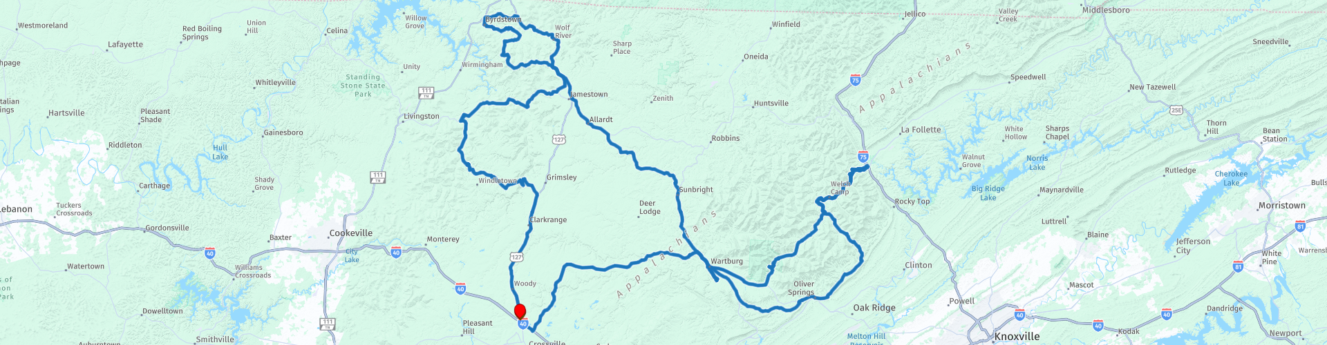
 We’ll start in the parking lot of the Baymont by Wyndham motel and head southeast down to the next exit to take TN298 over to Wartburg. From there continue east through the winding hills and rejoin TN62 just west of Oliver Springs where there are couple of nice places to stop if you’re inclined.
Oliver Springs is the southernmost point on a great ride known as the Devil’s Triangle. We’ll continue NE on TN330 to Dutch Valley where we’ll join TN116 and head NW. At Stainville there’s a decision: Stay on the planned route and head down to Caryville and back on one of the best one-lane set of switchbacks you’ll find in the area . . . or skip that part and continue on TN116. Note that the Caryville choice does have a couple miles of gravel which some travelers wish to avoid.
Back on TN116 we’ll go SW through some awesome hoopties and switchbacks. Be careful as there are no guardrails along much of this road and the drop-offs are breathtaking! The last few miles before WP22 are particularly noteworthy, and lead up to lunchtime at the site of the historic Brushy Mountain State Penitentiary. This facility was a maximum security prison for about 110 years, notably famous for being the site from which James Earl Ray escaped briefly and is home to the superhuman Barkley Marathon that is run in the area. It’s now a museum and has the Warden’s Table restaurant on-site—a good place for lunch.
Continuing on, we’ll rejoin TN62 and head west on a relaxing drive north before again going NW through some great countryside—the hills and valleys north of Crossville and just south of the Big South Fork Recreation Area. We’ll wind our way through several mountain loops and end up back at the Baymont.
I've rated this a "4" as an average. There is substantial 5-star fun here, but some of the great points require mundane highway travel between them. There are challenging curves and switchbacks which do require attention paid for safety.


 Links
Links  Usage
Usage Want to download this route?
You can download the route for free without MyRoute-app account. To do so, open the route and click 'save as'. Want to edit this route?
No problem, start by opening the route. Follow the tutorial and create your personal MyRoute-app account. After registration, your trial starts automatically.  Disclaimer
Use of this GPS route is at your own expense and risk. The route has been carefully composed and checked by a MyRoute-app accredited RouteXpert for use on TomTom, Garmin and MyRoute-app Navigation.
Changes may nevertheless have occurred due to changed circumstances, road diversions or seasonal closures. We therefore recommend checking each route before use.
Preferably use the route track in your navigation system. More information about the use of MyRoute-app can be found on the website under 'Community' or 'Academy'.