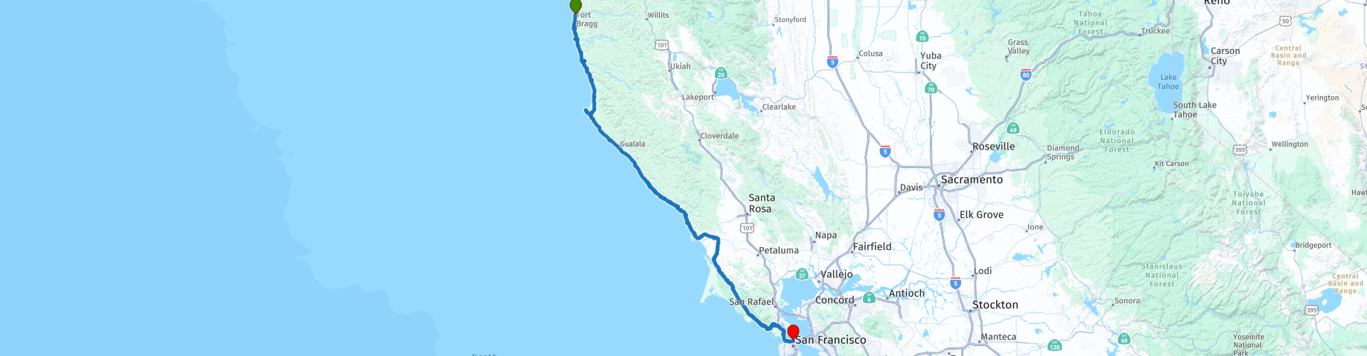
Day 120 The Ultimate USA road trip Fort Bragg San Francisco

This route was brought to you by:
RouteXpert René Plücken (MRA Master)
Last edit: 08-04-2024
 Route Summary
 I have further supplemented the Road Trip with even more special points that you can visit in the USA. Today we drive from Fort Bragg along the Pacific Coast and along Shoreline Highway 1 to San Francisco. It is a journey of more than 300 kilometers.
We drive on the beautiful Shoreline Highway 1 in California, this is part of the Pacific Coast Scenic Byway. This is the major north-south US highway that starts in Washington and runs along the western coastline of Oregon to the California border. Along the way you will enjoy beautiful views and there are several sights to visit and very beautiful viewpoints. I rate this route 5 stars.
 Share this route


Animation

Verdict


Duration
10h 10m

Mode of travel
Car or motorcycle

Distance
301.56 km

Countries

 RouteXpert Review
 If you want to enjoy a few hours at the beach, there are several options along this route, such as "Jug handle Beach" on the rugged coast of Mendocino. This beach beckons visitors with its spectacular ocean views, peaceful forests, and a walk through half a million years of ecological history. This beach is part of the Jug Handle Reserve State Park, which, with its 2.5-mile Ecological Staircase Trail, is one of the few places on Earth that provides a more complete picture of how the geology, soils and plants changed over time. Near the beach are three wave-carved terraces formed by the continental glaciers, rising seas and tectonic plates that built the Coast Range.
We visit “Point Cabrillo State Historic Park”, which covers a spectacular headland that extends into the Pacific Ocean. There is a parking lot inside the Point Cabrillo Drive gate, adjacent to the restored Kearn farm. Enjoy the half-mile downhill walk to the Light Station buildings. There are two routes to the station. The dirt trail starts at the north end of the parking lot and takes you through introduced grassland and coastal prairie. The paved access road to the south is an easier walk.
We stop to take a photo at the “Russian Gulch Bridge”, for this we have to take a short walk to the viewpoint where you have a nice view of the “Russian Gulch Bridge” which is officially called “Frederick W. Panhorst Bridge”. It is an arch bridge with open parapet of reinforced concrete on California State Highway 1, spanning Russian Gulch Creek. It is named after Frederick W. Panhorst, who served as bridge section chief of the California Division of Highways from 1931 to 1960.
Mendocino is a cozy, picturesque coastal town in Northern California. It is known for its natural beauty and beautiful coastline. There are several attractions near Mendocino, including state parks with tall redwoods and the famous 'Glass Beach'. Despite Mendocino's small size, it is extremely popular among vacationers and artists. There are many attractive accommodations such as B&Bs and small-scale hotels. This is an excellent place to take a break to take a walk and have a coffee in one of the many cafes.
We visit “Point Arena-Lighthouse”, built of brick and mortar in 1869. The tower housed a Fresnel lens of the first order. The tower was 30 meters high. The great earthquake of 1906 damaged the lighthouse beyond repair and destroyed the lens. It is speculated that the spiral staircase prevented the tower from collapsing. The original staircase is still in use in the second tower. You can also plan a lunch stop in Point Arena.
After lunch we visit Fort Ross, a former Russian establishment on the west coast of North America in what is now Sonoma County, California. It was the center of the southernmost Russian settlements in North America from 1812 to 1841. Notably, it was the first multi-ethnic community in Northern California, with a combination of native Californians, native Alaskans, Russians, Finns, and Swedes. It is a California Historic Landmark, a National Historic Landmark and listed on the National Register of Historic Places.
There are many beautiful viewpoints along the route, some of which are indicated with a RP and POI, which are highly recommended;
• Sentinel Rock Viewing Platform and enjoy views of the rugged Pacific coastline. It's a short walk to the platform.
• Duncan Landing Overlook with extraordinary views of the breathtaking scenery of the Sonoma Coast. The point also offers views of Wright's Beach, where you can see large waves rolling in and thundering against the rocks. Seagulls circle overhead and seals bask in the sun beneath the cliffs.
• Stop at Arch Rock Vista Point. North of Arched Rock Beach you will see the large rock with a hole in it.
• Coleman Beach Overlook is another good place to admire views of the Pacific coast.
• Enjoy the view at Muir Beach Overlook. It's a short walk to the platform.
As mentioned earlier, there are many beautiful beaches, one of my personal favorites is Stinson Beach, a great town with a nice large clean beach, ample parking spaces and in the village there are a number of nice restaurants and bars. Enjoy the sunset on this beautiful beach.
We drive to San Francisco via Sausalito. Sausalito is a very charming town on Richardson Bay, with colorful buildings, shops, a boardwalk and exceptionally good restaurants. Located on the other side of the Golden Gate Bridge from San Francisco, it offers views of Richardson Bay, San Francisco Bay, Angel Island and “The Rock” with Alcatraz, but only when there is no fog. Sausalito is definitely recommended to visit, so we plan an extra day in San Francisco to visit this town and some other sights, more about that in the itinerary of day 121.
We cross the world famous Golden Gate Bridge to our final destination San Francisco. Stop at the Golden Gate Bridge toll booth to pay the toll. This can be done with a FasTrak account, a vehicle registration bill, a toll bill or a one-time payment using a credit card, cash, check or money order. These can be paid online, by telephone or in person at a cash payment location in the city. Costs range between $8.75 and $9.75 for a motorcycle.
As we leave the bridge we drive through San Francisco Presidio, which was originally a Spanish fort from 1776. In the current park there are several wooded areas, hills and tourist viewpoints over the Golden Gate Bridge, San Francisco Bay and the Pacific Ocean . Since 1962, the park has been recognized as a National Historic Landmark.
We drive into San Francisco and already feel at home in the many American films, with its steep streets and beautiful stately mansions. We drive up the steep Lombard Street and then descend again via the winding part of this famous road, with its 8 sharp hairpin bends a true attraction. Drive slowly and enjoy the ride. Find a parking lot at the bottom of the road to take photos.
The end point is “Fisherman's Wharf”, a beautiful location with many hotels, good restaurants and cozy cafes. San Francisco has a lot to offer its visitors, visit the cozy piers at Fisherman's Wharf, with cozy restaurants and of course the sea lions (it stinks), Alcatraz on “The Rock” will give you goosebumps, enjoy delicious chocolate on Ghirardelli Square and of course a ride with the Cable Car to the center is a must.


 Links
Links  Usage
Usage Want to download this route?
You can download the route for free without MyRoute-app account. To do so, open the route and click 'save as'. Want to edit this route?
No problem, start by opening the route. Follow the tutorial and create your personal MyRoute-app account. After registration, your trial starts automatically.  Disclaimer
Use of this GPS route is at your own expense and risk. The route has been carefully composed and checked by a MyRoute-app accredited RouteXpert for use on TomTom, Garmin and MyRoute-app Navigation.
Changes may nevertheless have occurred due to changed circumstances, road diversions or seasonal closures. We therefore recommend checking each route before use.
Preferably use the route track in your navigation system. More information about the use of MyRoute-app can be found on the website under 'Community' or 'Academy'.

California
About this region
California is a state in the Western United States. It shares a border with Oregon to the north, Nevada and Arizona to the east, and the Mexican state of Baja California to the south. With over 39.5 million residents across a total area of approximately 163,696 square miles (423,970 km2), it is the most populous and the third-largest U.S. state by area. It is also the most populated subnational entity in North America and the 34th most populous in the world. The Greater Los Angeles area and the San Francisco Bay Area are the nation's second and fifth most populous urban regions respectively, with the former having more than 18.7 million residents and the latter having over 9.6 million. Sacramento is the state's capital, while Los Angeles is the most populous city in the state and the second most populous city in the country (after New York City). Los Angeles County is the country's most populous, while San Bernardino County is the largest county by area in the country. San Francisco, which is both a city and a county, is the second most densely populated major city in the country (after New York City) and the fifth most densely populated county in the country, behind four of New York City's five boroughs.
The economy of California, with a gross state product of $3.2 trillion as of 2019, is the largest sub-national economy in the world. If it were a country, it would be the 37th most populous country and the fifth largest economy as of 2020. The Greater Los Angeles area and the San Francisco Bay Area are the nation's second- and third-largest urban economies ($1.0 trillion and $0.5 trillion respectively as of 2020), after the New York metropolitan area ($1.8 trillion). The San Francisco Bay Area Combined Statistical Area had the nation's highest gross domestic product per capita ($106,757) among large primary statistical areas in 2018, and is home to five of the world's ten largest companies by market capitalization and four of the world's ten richest people.Prior to European colonization, California was one of the most culturally and linguistically diverse areas in pre-Columbian North America and contained the highest Native American population density north of what is now Mexico. European exploration in the 16th and 17th centuries led to the colonization of California by the Spanish Empire. In 1804, it was included in Alta California province within the Viceroyalty of New Spain. The area became a part of Mexico in 1821, following its successful war for independence, but was ceded to the United States in 1848 after the Mexican–American War. The western portion of Alta California was then organized and admitted as the 31st state on September 9, 1850, following the Compromise of 1850. The California Gold Rush started in 1848 and led to dramatic social and demographic changes, including large-scale immigration into California, a worldwide economic boom, and the California genocide of indigenous people.
Notable contributions to popular culture, for example in entertainment and sports, have their origins in California. The state also has made noteworthy contributions in the fields of communication, information, innovation, environmentalism, economics, and politics. It is the home of Hollywood, the oldest and largest film industry in the world, which has had a profound effect on global entertainment. It is considered the origin of the hippie counterculture, beach and car culture, and the personal computer, among other innovations. The San Francisco Bay Area and the Greater Los Angeles Area are widely seen as centers of the global technology and entertainment industries, respectively. California's economy is very diverse: 58% of it is based on finance, government, real estate services, technology, and professional, scientific, and technical business services. Although it accounts for only 1.5% of the state's economy, California's agriculture industry has the highest output of any U.S. state. California's ports and harbors handle about a third of all U.S. imports, most originating in Pacific Rim international trade.
The state's extremely diverse geography ranges from the Pacific Coast and metropolitan areas in the west to the Sierra Nevada mountains in the east, and from the redwood and Douglas fir forests in the northwest to the Mojave Desert in the southeast. The Central Valley, a major agricultural area, dominates the state's center. Although California is well known for its warm Mediterranean climate and monsoon seasonal weather, the large size of the state results in climates that vary from moist temperate rainforest in the north to arid desert in the interior, as well as snowy alpine in the mountains. All these factors lead to an enormous demand for water. Over time, droughts and wildfires have increased in frequency and become less seasonal and more year-round, further straining California's water security.
Read more on Wikipedia
The economy of California, with a gross state product of $3.2 trillion as of 2019, is the largest sub-national economy in the world. If it were a country, it would be the 37th most populous country and the fifth largest economy as of 2020. The Greater Los Angeles area and the San Francisco Bay Area are the nation's second- and third-largest urban economies ($1.0 trillion and $0.5 trillion respectively as of 2020), after the New York metropolitan area ($1.8 trillion). The San Francisco Bay Area Combined Statistical Area had the nation's highest gross domestic product per capita ($106,757) among large primary statistical areas in 2018, and is home to five of the world's ten largest companies by market capitalization and four of the world's ten richest people.Prior to European colonization, California was one of the most culturally and linguistically diverse areas in pre-Columbian North America and contained the highest Native American population density north of what is now Mexico. European exploration in the 16th and 17th centuries led to the colonization of California by the Spanish Empire. In 1804, it was included in Alta California province within the Viceroyalty of New Spain. The area became a part of Mexico in 1821, following its successful war for independence, but was ceded to the United States in 1848 after the Mexican–American War. The western portion of Alta California was then organized and admitted as the 31st state on September 9, 1850, following the Compromise of 1850. The California Gold Rush started in 1848 and led to dramatic social and demographic changes, including large-scale immigration into California, a worldwide economic boom, and the California genocide of indigenous people.
Notable contributions to popular culture, for example in entertainment and sports, have their origins in California. The state also has made noteworthy contributions in the fields of communication, information, innovation, environmentalism, economics, and politics. It is the home of Hollywood, the oldest and largest film industry in the world, which has had a profound effect on global entertainment. It is considered the origin of the hippie counterculture, beach and car culture, and the personal computer, among other innovations. The San Francisco Bay Area and the Greater Los Angeles Area are widely seen as centers of the global technology and entertainment industries, respectively. California's economy is very diverse: 58% of it is based on finance, government, real estate services, technology, and professional, scientific, and technical business services. Although it accounts for only 1.5% of the state's economy, California's agriculture industry has the highest output of any U.S. state. California's ports and harbors handle about a third of all U.S. imports, most originating in Pacific Rim international trade.
The state's extremely diverse geography ranges from the Pacific Coast and metropolitan areas in the west to the Sierra Nevada mountains in the east, and from the redwood and Douglas fir forests in the northwest to the Mojave Desert in the southeast. The Central Valley, a major agricultural area, dominates the state's center. Although California is well known for its warm Mediterranean climate and monsoon seasonal weather, the large size of the state results in climates that vary from moist temperate rainforest in the north to arid desert in the interior, as well as snowy alpine in the mountains. All these factors lead to an enormous demand for water. Over time, droughts and wildfires have increased in frequency and become less seasonal and more year-round, further straining California's water security.
View region
 Statistics
  43
43Amount of RX reviews (California)
 29614
29614Amount of visitors (California)
 768
768Amount of downloads (California)
 Route Collections in this region
 Car or motorcycle tour through the western US
This collection contains all 15 routes driven by MRA Goldmember André ter Schegget during his three-week tour through the west of America.
The places to visit, the attractions and beautiful photo spots are nicely marked on the routes. The routes have been fully checked and made equal for the Garmin and the TomTom. Enjoy this wonderful trip and let us know how it was! Enjoy and stay safe!
Order of the tour:
Route 01: from Los Angeles and via Pacific Coast Highway to Solvang
Route 02: Solvang to Monterey / Pacific Grove
Route 03A: Monterey to San Francisco
Route 03B: if you are by car instead of the motorcycle, as motorcycles are not allowed on the 17 Mile Drive: from Monterey to the 17 Mile Drive and further to San Francisco
Route 04: from San Francisco via Nappa and Eldorado National Forrest to Topaz Lake
Route 05: from Topaz Lake via Bodie and Yosemite to Oakhurst
Route 06: from Oakhurst via Kings Canyon NP and Sequoia NP and Giant Forest to Exeter
Route 07: Exeter via Isabella Lake and Ridgecrest to Death Valley
Route 08: from Death Valley via Valley Of Fire to Mesquite
Route 09: from Mesquite via Zion NP and Dixie NF to Hatch
Route 10: Hatch via Bryce Canyon to Page
Route 11: from Page via Grand Canyon to Williams
Route 12: from Williams via Seligman and Route 66 to Kingman and via Hoover Dam to Las Vegas
Route 13: from Las Vegas via Oatman and Lake Havasu to Parker
Route 14: from Parker via Joshua Tree to Rancho Mirage
Route 15: Rancho Mirage via Palm Springs to Santa Monica
View Route Collection
The 10 most downloaded routes in the USA from RouteXpert Hans van de Ven
Hello and welcome to this collection of the Top 10 MyRoute app downloaded routes in USA.
There will be a great new event to be announced soon, where all these routes can be driven.
Download them all now and place them in a new "Top 10" folder, so that you always have them at hand.
If you are going to drive one of these routes in the meantime, track them with the MRA Mobile App or with MRA Navigation. Take some photos (moments) along the way as these will come in handy.
Create a travelogue of your Top 10 driven routes and add the recorded track to it.
There will also be some great prizes on offer, so keep an eye on the MRA-RouteXperts page and your mail.
The 10 routes are:
1. D13 Estes Park Denver
2. D03 Chadron Custer
3. D01 Pigeon Forge round trip through the Smokey Mountains
4. D08 Kalispell Sandpoint
5. D10 Colville Wenatchee
6. D09 Sandpoint Colville
7. D04 Custer Wall
8. D11 Wenatchee Seattle
9. D08 Cody Yellowstone NP
10.R13 San Francisco Monterey
View Route Collection