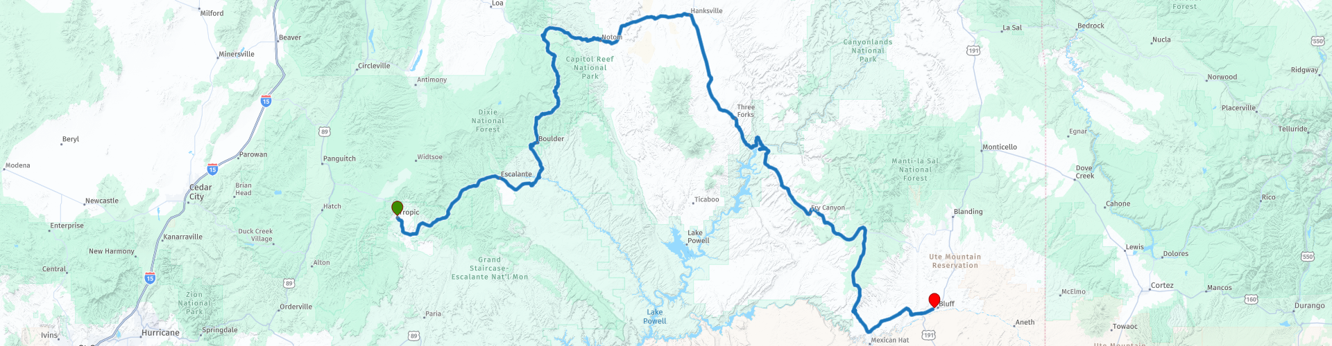
Day 06 Tropic to Bluff through Capitol Reef National Park

This route was brought to you by:
RouteXpert Paul Hedges - Adv RouteXpert
Last edit: 28-01-2022
 Route Summary
 Rocks in every formation and every colour. A trip that can be done in a day or a week, or even longer. It just depends on how many of of the turns along the road can tempt you.
Enjoy this 4 Star day of ever changing colours in the scenic byways of Utah
 Share this route


Animation

Verdict


Duration
9h 50m

Mode of travel
Car or motorcycle

Distance
481.57 km

Countries

 RouteXpert Review
 As ever start the day with a full fuel tank.
Today we will experience 100 miles of pure driving bliss along Utah RT12. We have already done 21 miles of the road as you travelled through Red Canyon yesterday so today just continues the good stuff.
So time to head out and experience some more of Utah’s Scenic Byway 12, also known as “A Journey Through Time Scenic Byway.” This trip can be done in 3 hours, or could take 3 days. It really depends on the purpose of the visit.
Stunning vistas will dazzle and amaze. Along the way you’ll travel through some of the most diverse and ruggedly beautiful landscapes in the country. This is one pretty epic road as it plays host to two national parks, three state parks, a national monument, and a national forest.
From Escalante, geographically located near the midpoint of the byway, the road turns north winding through vast expanses of slickrock country. Along the way travellers are rewarded with views of the Escalante River (RP8), Calf Creek Canyon (RP9), and the Hogsback (RP10) and Boulder Mountain. At Boulder visitors can get a first-hand look at life in a prehistoric Native American village at the Anasazi Indian Village Park (RP13).
Continuing north from Boulder, still on SR-12, the road crosses the eastern flank of Boulder Mountain with spectacular views across Capitol Reef National Park from Homestead Overlook (RP14) and Steep Creek Overlook (RP15). On a clear day travellers can see more than 100 miles into Colorado and Arizona.
As Scenic Byway 12 comes to an end at Torrey we traverse to Scenic Route 24 as we aim towards Hanksville. This road will navigate us through Capitol Reef National Park with it's steep sides of orange rock. After a few miles, especially once you get to Caineville and beyond, the landscape around UT-24 transforms and suddenly becomes an arid and inhospitable alien territory with a variety of colours, including grey, pale yellow, purple and above all blue.
Hanksville, a small remote town with a hippie soul that serves as an important crossroads is where we will stop for liquid and head south along UT-95, The Bicentennial Scenic Highway, is every road in Utah a scenic byway?
The name comes from the fact the road wasn't fully paved until 1976, in time for the United States Bicentennial celebrations. There is a gas station at Hite Marina (RP35)that is usually open in the summer. Other than that, this is pretty wide open, unpopulated countryside.
The next 130 miles have very little in the way of civilisation, but instead you might feel yourself transported to another planet with the harsh and alien scenery. This is stark red rocks country, vegetated mostly by junipers, chamisa, cacti, sagebrush and creosote bush. The ancient sandstone landscape has been heavily carved by the forces of wind and water since the Colorado Plateau was uplifted about 65 million years ago.
Take time to stop and view the Colorado River and Lake Powell from the Hite Overlook (RP31). Upon completion of Glen Canyon Dam on September 13, 1963, the Colorado River began to back up, no longer being diverted through the tunnels. The newly flooded Glen Canyon formed Lake Powell. Although not as full now as it has been it is still one of the largest fresh water reservoirs in the USA.
The road forks when it meets UT261 we head south towards Mexican Hat until we arrive at the Moki Dugway. The road was constructed in 1958 to provide a way to haul ore from the Happy Jack Mine on Cedar Mesa to the mill in Halchita, near Mexican Hat. The term "mokee" is derived from the Spanish word moqui, which was a general term used by the 18th century Spanish explorers and settlers in this region to describe the Pueblo Indians they encountered and the vanished culture which had left behind the numerous ruins they discovered during their travels. This term continued to be used by the Anglo pioneers, who moved into southern Utah during the 1800's, and their descendants.
As well as his section is three miles of unpaved, but well graded, switchbacks descending 335m (1100 ft). The switchbacks not only giving amazing views of the road but also into the neighbouring Valley of The Gods (RP39).
Normality is soon resumed and all wheels are back on tarmac and we are turning and heading towards the small town of Bluff to bed down for the night


 Links
Links  Usage
Usage Want to download this route?
You can download the route for free without MyRoute-app account. To do so, open the route and click 'save as'. Want to edit this route?
No problem, start by opening the route. Follow the tutorial and create your personal MyRoute-app account. After registration, your trial starts automatically.  Disclaimer
Use of this GPS route is at your own expense and risk. The route has been carefully composed and checked by a MyRoute-app accredited RouteXpert for use on TomTom, Garmin and MyRoute-app Navigation.
Changes may nevertheless have occurred due to changed circumstances, road diversions or seasonal closures. We therefore recommend checking each route before use.
Preferably use the route track in your navigation system. More information about the use of MyRoute-app can be found on the website under 'Community' or 'Academy'.

Utah
About this region
Utah ( YOO-tah, YOO-taw) is a state in the Mountain West subregion of the Western United States. It is bordered by Colorado to the east, Wyoming to the northeast, Idaho to the north, Arizona to the south and Nevada to the west. It also touches a corner of New Mexico in the southeast. Of the fifty U.S. states, Utah is the 13th-largest by area; with a population over three million, it is the 30th-most-populous and 11th-least-densely populated. Urban development is mostly concentrated in two areas: the Wasatch Front in the north-central part of the state, which is home to roughly two-thirds of the population and includes the capital city, Salt Lake City; and Washington County in the southwest, with more than 170,000 residents. Most of the western half of Utah lies in the Great Basin.
Utah has been inhabited for thousands of years by various indigenous groups such as the ancient Puebloans, Navajo and Ute. The Spanish were the first Europeans to arrive in the mid-16th century, though the region's difficult geography and harsh climate made it a peripheral part of New Spain and later Mexico. Even while it was Mexican territory, many of Utah's earliest settlers were American, particularly Mormons fleeing marginalization and persecution from the United States. Following the Mexican–American War in 1848, the region was annexed by the U.S., becoming part of the Utah Territory, which included what is now Colorado and Nevada. Disputes between the dominant Mormon community and the federal government delayed Utah's admission as a state; only after the outlawing of polygamy was it admitted in 1896 as the 45th.
Slightly over half of all Utahns are Mormons, the vast majority of whom are members of The Church of Jesus Christ of Latter-day Saints (LDS Church), which has its world headquarters in Salt Lake City; Utah is the only state where a majority of the population belongs to a single church. The LDS Church greatly influences Utahn culture, politics, and daily life, though since the 1990s the state has become more religiously diverse as well as secular.
Utah has a highly diversified economy, with major sectors including transportation, education, information technology and research, government services, mining, and tourism. Utah has been one of the fastest growing states since 2000, with the 2020 U.S. Census confirming the fastest population growth in the nation since 2010. St. George was the fastest-growing metropolitan area in the United States from 2000 to 2005. Utah ranks among the overall best states in metrics such as healthcare, governance, education, and infrastructure. It has the 14th-highest median average income and the least income inequality of any U.S. state. A 2012 Gallup national survey found Utah overall to be the "best state to live in the future" based on 13 forward-looking measurements including various economic, lifestyle, and health-related outlook metrics.
Read more on Wikipedia
Utah has been inhabited for thousands of years by various indigenous groups such as the ancient Puebloans, Navajo and Ute. The Spanish were the first Europeans to arrive in the mid-16th century, though the region's difficult geography and harsh climate made it a peripheral part of New Spain and later Mexico. Even while it was Mexican territory, many of Utah's earliest settlers were American, particularly Mormons fleeing marginalization and persecution from the United States. Following the Mexican–American War in 1848, the region was annexed by the U.S., becoming part of the Utah Territory, which included what is now Colorado and Nevada. Disputes between the dominant Mormon community and the federal government delayed Utah's admission as a state; only after the outlawing of polygamy was it admitted in 1896 as the 45th.
Slightly over half of all Utahns are Mormons, the vast majority of whom are members of The Church of Jesus Christ of Latter-day Saints (LDS Church), which has its world headquarters in Salt Lake City; Utah is the only state where a majority of the population belongs to a single church. The LDS Church greatly influences Utahn culture, politics, and daily life, though since the 1990s the state has become more religiously diverse as well as secular.
Utah has a highly diversified economy, with major sectors including transportation, education, information technology and research, government services, mining, and tourism. Utah has been one of the fastest growing states since 2000, with the 2020 U.S. Census confirming the fastest population growth in the nation since 2010. St. George was the fastest-growing metropolitan area in the United States from 2000 to 2005. Utah ranks among the overall best states in metrics such as healthcare, governance, education, and infrastructure. It has the 14th-highest median average income and the least income inequality of any U.S. state. A 2012 Gallup national survey found Utah overall to be the "best state to live in the future" based on 13 forward-looking measurements including various economic, lifestyle, and health-related outlook metrics.
View region
 Statistics
  19
19Amount of RX reviews (Utah)
 14140
14140Amount of visitors (Utah)
 410
410Amount of downloads (Utah)
 Route Collections in this region
 Car or motorcycle tour through the western US
This collection contains all 15 routes driven by MRA Goldmember André ter Schegget during his three-week tour through the west of America.
The places to visit, the attractions and beautiful photo spots are nicely marked on the routes. The routes have been fully checked and made equal for the Garmin and the TomTom. Enjoy this wonderful trip and let us know how it was! Enjoy and stay safe!
Order of the tour:
Route 01: from Los Angeles and via Pacific Coast Highway to Solvang
Route 02: Solvang to Monterey / Pacific Grove
Route 03A: Monterey to San Francisco
Route 03B: if you are by car instead of the motorcycle, as motorcycles are not allowed on the 17 Mile Drive: from Monterey to the 17 Mile Drive and further to San Francisco
Route 04: from San Francisco via Nappa and Eldorado National Forrest to Topaz Lake
Route 05: from Topaz Lake via Bodie and Yosemite to Oakhurst
Route 06: from Oakhurst via Kings Canyon NP and Sequoia NP and Giant Forest to Exeter
Route 07: Exeter via Isabella Lake and Ridgecrest to Death Valley
Route 08: from Death Valley via Valley Of Fire to Mesquite
Route 09: from Mesquite via Zion NP and Dixie NF to Hatch
Route 10: Hatch via Bryce Canyon to Page
Route 11: from Page via Grand Canyon to Williams
Route 12: from Williams via Seligman and Route 66 to Kingman and via Hoover Dam to Las Vegas
Route 13: from Las Vegas via Oatman and Lake Havasu to Parker
Route 14: from Parker via Joshua Tree to Rancho Mirage
Route 15: Rancho Mirage via Palm Springs to Santa Monica
View Route Collection
Top car and motorcycle tour through the west of the USA
By car or motorcycle through the West of America is a journey that you do not just make, so also not driving 15 days and then back home. No, book a stay of several days in Los Angeles, Las Vegas, San Francisco and again Los Angeles to also visit several places of interest in these cities, so that this tour becomes an unforgettable tour that you can remember with pleasure.
Do not forget to arrange and pack the following items:
*This is only a summary and completely personal and may differ per person.
Take out travel insurance, +31 for numbers in GSM, (partially) take out gas, Health insurance coverage at destination?, Switch off electrical appliances, Lighting (time clock), Check passport validity, Antenna from radio/TV due to lightning, Residence address for those left behind, Remote control house alarm, Book Smart Parking.
Hand luggage:
Liquids in packaging of max. 100 ml, Liquids in hand luggage in transparent plastic bag.
For on the road:
Candy, Book, Earplugs, Country and road map(s), Directions, Maps in your navigation system
Money & Securities:
Bank card / giro card, Credit card (think pin code), Cash, Calculator for Internet banking, Medical insurance card, Travel insurance card.
Travel documents:
Passport, (International) Driver's License, Ticket(s), Reservation Tickets, Hotel Vouchers, Arrival/Departure Time, Check-in & Check-out Times, Valid Visa (ESTA), Travel Guide.
Clothing:
Underwear, Belt, Shirts/ T-shirts, Shorts, Long pants, Shoes, Socks, Swim trunks, Towel, Slippers.
Personal stuff:
Watch, House Keys, Wallet, Sunglasses.
Toiletries:
Deodorant, Shower gel / Soap, Comb / brush, Shaving equipment, Shampoo, Toothbrush, Toothpaste, Sanitary pads
Health & Medicine:
Own medicines, Insect repellent, Cold sore ointment, Ointment for insect bites, Sunscreen, Norit, Paracetamol, Suction cup for insect bites, First aid bag.
Miscellaneous:
Travel bag / waist bag, Leatherman (= checked luggage), Pen or pencil, Headlamp, Lighter, Tools & Electronics, Mobile phone & charger, Photo/video camera & charger, Memory card(s), World plug / adapter, Ipod & charger, Adapter cable Ipod, Headphones, iPad & charger, Navigation & charger/plug, Plug socket, Fuelpack battery.
Engine (accessories):
Helmet, Motorcycle clothing, Motorcycle boots, Chain lock / disc brake lock, Gloves, Bandana, Inner bags (plastic shopping bag), Insulation bag, Tension straps, Tie wraps, Rain suit, Rainaway.
Addresses:
Address list, Embassy telephone number, Telephone number to block (bank) card(s), Telephone number (airline tickets).
View Route Collection