R47 SA Roundtrip Adelaide South

This route was brought to you by:
RouteXpert Hans van de Ven (Mr.MRA)
Last edit: 15-04-2021
 Route Summary
 Australia is very big; 8 million km2, that is more than 226 times larger than the Netherlands! Has a diversity of flora and fauna; the most diverse types of plants, trees and animals, especially birds and a lot of typical Australian marsupials, which you will not find anywhere else in the world!
Enjoy all the beauty enormously: From the evergreen tropical rainforests, to the vast Outback; from the desert to the countless and quiet idyllic palm beaches; from the winter sports areas in the south-east to the vibrant and impressive metropolis of Melbourne, Sydney and Perth.
You will see and experience it all in this great tour of Australia, a tour to remember!
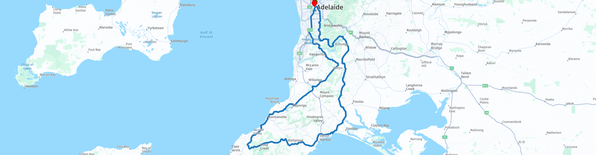
Start & End Point: Adelaide, Adelaide Inn
The route is made equal for TomTom, Garmin and MyRoute-app Navigation users.
NOTE: DRIVE LEFT!
 Share this route


Animation

Verdict


Duration
7h 8m

Mode of travel
Car or motorcycle

Distance
290.55 km

Countries

 RouteXpert Review
 Built in 1902 for Joseph Gamble, an orchardist who worked in the (then) nearby Government Experimental Orchard, the Cottage and Garden with his family name were bequeathed in 1982 by two of his daughters, Clara and Edith, to the town of Mitcham for use by the local community. Then you set course for the Scott Creek Conversation Park. You go again via the Adelaide Hills through Dorset Vale. Winding through the beautiful landscape you will arrive in the town of Ashbourne, where the 1st stop is also planned at The Greenman Inn. Stop after the break to capture an Aboriginal Canoe Tree in the photo, a scarred tree or scar tree, also known as a canoe tree and shield tree, is a tree whose bark has been removed by Aboriginal Australians to make bark canoes, hideouts, weapons such as shields, tools, traps, containers, or other artifacts.
Once you arrive in Port Eliot, you will try to spot a whale on the pre-existing plateau on the coast. After whale watching, head west to enjoy the views from the Hobart Memorial Lookout, and to pause to reflect on one of Australia's greatest naval hunters, including the Royal Australian Navy's first battleship to become deployed to fight in the Vietnam War and was part of the Royal Australian Navy's disaster response after Cyclone Tracy in Darwin in 1974, before decommissioning in 2000. In Normanville, you can refuel if necessary and here is also the 2nd stop planned for something to eat. After lunch, swing on to stop again at the Myponga Reservoir Lookout to take some photos. The Myponga Reservoir, when full, covers an area of about 280 hectares. The Myponga Reservoir is fed by the Myponga River.
When you have crossed the Onkaparinga River for the 2nd time, the contours of Adelaide start to become visible again, another hour's drive, refuel opposite the hotel and then take another dip in the pool.
This route also goes through the outback, these are regions that are far from civilization. The outback covers almost three quarters of Australia and mainly extends across the Northern Territory and Western Australia, and parts of the states of Queensland, New South Wales and South Australia.
The term outback includes different landscapes and climatic zones. Large parts of the outback in Western Australia are inaccessible: sometimes there is no rain here for years, while in summer the temperature rises above 50 ° C. The Queensland outback, on the other hand, consists partly of tropical rainforest.
The characteristics of the outback are:
- Only a few asphalt roads are present. Farms (stations) are often located on sandy paths that can only be used by off-road vehicles. It is no exception when a farm is located 80 kilometers from the asphalt road.
- Farms are designed for self-catering. It is not a problem if a supermarket cannot be visited for weeks.
- Settlements with a few houses, a gas station, a supermarket, a garage, a bank and catering establishments are hundreds of kilometers apart.
- Children receive distance education via the radio (School of the Air) and the Internet.
- The Royal Flying Doctor Service (RFDS) is called upon for serious illnesses and accidents.
Camels were imported from the Middle East in 1870. They live partly on farms, partly in the wild.
- Of the approximately 300,000 Aborigines (approximately 1.5% of the total population of Australia), approximately 20% live in the outback, most of them in reserves.
This 4-star rated route has mostly very good roads, through hills, and some nice little places where you can meet the locals. Definitely try if you can spot a whale.
General info:
South Australia (English: South Australia) is a state with an area of 983,482 km² it is the third largest state in the country. About one eighth of South Australia is occupied by the Woomera Prohibited Area military test site.
Many names in and around this state refer to Matthew Flinders and Nicolas Baudin. These explorers had been sent out from England and France respectively to explore the south coast of Australia and claim the land. South Australia is Australia's driest state and much of it is arid and desert-like. The eastern portion of the Great Victoria Desert is in this state. In the northeast are the infamous Simpson Desert and the Tirari Desert. About 50% of the national wine production takes place in this state. Most winegrowers can be found in the southeast of the state on the border with Victoria.
The first recorded European sighting of the South Australian coast was in 1627 when the Dutch ship Gulden Zeepaert, commanded by François Thijssen, surveyed and mapped part of the coastline as far as the Nuyts archipelago. The land that now forms the state of South Australia was claimed for Great Britain in 1788 as part of the New South Wales colony. Unlike the rest of Australia, terra nullius did not apply to the new province. The Letters Patent, which used the enabling provisions of the South Australia Act 1834 to establish the boundaries of the province of South Australia, provided that "nothing in our Letters Patent affects or can be construed as a influence on the rights of an Aboriginal. Despite a strong reference to the rights of the indigenous people in the first proclamation by the governor, there was much conflict and deaths in the Australian border wars in South Australia. The beginning of the colonial government was proclaimed on December 28, 1836, now known as Proclamation Day.
South Australia is the only Australian state that has never received British convicts. In early 1838, settlers began to worry after it was reported that convicts who had escaped from the eastern states could go to South Australia. The South Australia Police was formed in April 1838 to protect the community and enforce government regulations. Their main role was to run the first temporary prison, a two-room cabin.
The current flag of South Australia was adopted on January 13, 1904 and is a British blue flag that is illegible with the state badge. The emblem is described as a piping shrike with wings outstretched on a yellow disk. The state badge is believed to have been designed by Robert Craig of Adelaide's School of Design.


 Links
Links  Usage
Usage Want to download this route?
You can download the route for free without MyRoute-app account. To do so, open the route and click 'save as'. Want to edit this route?
No problem, start by opening the route. Follow the tutorial and create your personal MyRoute-app account. After registration, your trial starts automatically.  Disclaimer
Use of this GPS route is at your own expense and risk. The route has been carefully composed and checked by a MyRoute-app accredited RouteXpert for use on TomTom, Garmin and MyRoute-app Navigation.
Changes may nevertheless have occurred due to changed circumstances, road diversions or seasonal closures. We therefore recommend checking each route before use.
Preferably use the route track in your navigation system. More information about the use of MyRoute-app can be found on the website under 'Community' or 'Academy'.