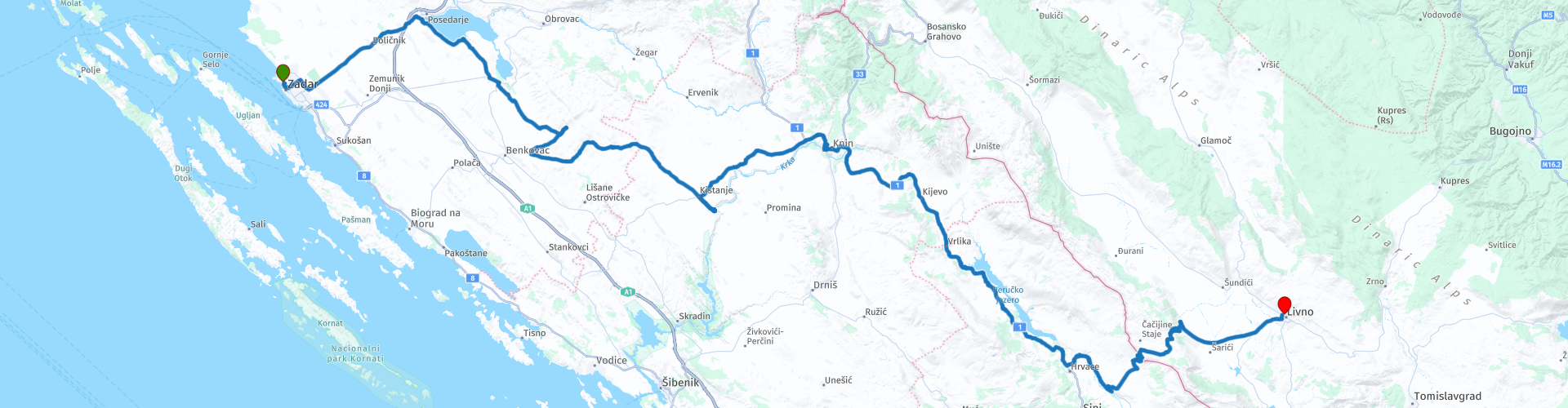
08 From Zadar to Livno via the Dinaric Alps and Krka Monastery

This route was brought to you by:
RouteXpert Leonor Orban - Sr. RouteXpert
Last edit: 28-04-2021
 Route Summary
 Today is mainly a day to move. The route is simple and offers little to no technical challenge. The scenery of the Dinaric Alps will keep your attention all day long, interspersed with interesting sights along the way.
You will be able to stop at Novigrad and enjoy delicious fresh fish, admire the monastery of Krka and fantasize about the Roman legion in Burnum.
 Share this route


Animation

Verdict


Duration
4h 57m

Mode of travel
Car or motorcycle

Distance
228.99 km

Countries


 RouteXpert Review
 Today you drive through a number of beautiful nature reserves in the interior of Croatia. We leave the sea and go deeper into the land, further east, to Bosnia and Herzegovina. Via a number of beautiful inland lakes and cultural heritage sites you meander along gently sloping wide roads to Livno, just across the border. Before you reach today's end point, you will be challenged a little bit by the mountain Trovrsi (1645m) which forces you to ascend about 850 meters over a stretch of 20 kilometers. This means some wonderfully swinging hairpin bends for dessert after an otherwise peaceful day.
Today you leave the coast. So enjoy your breakfast (with a view) and maybe you want to stretch your legs along the beach. The route is not too long with about 5 driving hours, so you can start slowly.
Just before you leave Zadar you can refuel at Adia Oil (rp 4). Today it is certainly also true that it is wise to refuel when a petrol station presents itself. There are not many of them on the road and running out of gasoline in the warm expanses of the interior is not recommended.
As indicated earlier, the route is quiet. You will notice this as soon as you leave the city. It is a long straight road, with few curves and, above all, great views. From time to time the road offers a gentle winding, but soon you can enjoy the views around you at your leisure. In good weather you can also see the highest mountains of the Dinaric Alps in the distance. Later today you will drive over this; for a long part of the route you will see it mainly from a distance.
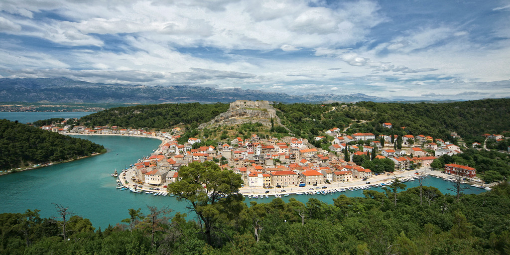
Your navigation system could almost make you insecure. The kilometers will certainly continue to slide under your wheels and there is no instruction. Only after about 30 minutes does the navigation wake up and ask you to leave the D8 and turn on the 6019. Here you immediately have a pleasant surprise: the sea of Novigrad.
The breeze from the sea immediately offers you some cooling. Because the Novigrad Sea is directly connected to the Adriatic Sea (via the Novsko ždrilo) and is supplied with fresh water via the Zrmanja River, the sea is rich in shellfish and fish. If you fancy an early break and like fresh fish and shellfish, you can turn right after route point 6 towards the city of Novigrad. This port town is located in a beautiful bay on the sea. The city is built on the remains of a fortress that in the past (together with the city walls) ran from the hill to the sea. There are several places to take a break in the city itself.
For a large part of the day the route goes along and through the Dinaric Alps. This mountain range is about 645 km long and stretches in the West from Italy to Albania in the East. You will notice that the vegetation here is minimal and often low growing. This is because the Dinaric Alps consist largely of the little fertile karts and limestone.
Once arrived in the small town of Kistanje, the route leads you into a dead end. Via this road you drive straight onto the Krka river.
The river is a total of 73 kilometers long and originates in the Dinaric Alps, close to the border with Bosnia and Herzegovina. Then she follows a route towards the Adriatic Sea where she slowly descends to sea level via many waterfalls. Further along the route you follow part of the river and if you are interested you can hike to a number of waterfalls in this river (route point 14).
For now you have arrived at the Serbian Orthodox Monastery of Krka (route point 11). The first mentions of this monastery date back to 1345. Due to the popularity of the monastery and its location in the middle of the Krka National Park, it has been given a protected status. If you are interested in visiting the monastery and learning more about the monks and the Krka river, it is best to visit their website and schedule an appointment for a tour. Part of the tour is done by boat and gives you the opportunity to admire the Roški waterfall up close.
Unfortunately, there are no opportunities to take a break at the monastery. Fortunately, you can “moor” a little further on the route at Restaurant Burnum (route point 12). This restaurant is named after a Roman legion camp located further up the route. The camp probably dates from 33 BC and served as a post to control traffic along the Krka River, especially at the time of Claudius. At the archaeological site (route point 13) you will now find the remains of an amphitheater, an underground aqueduct (to keep water cool in the summer) and a ruin with a number of arches. Because the location is right along the route, you can park and view the remains with ease.
Near Burnum you can also visit a number of impressive waterfalls, which make the Krka river so beautiful. You can walk (or drive) to a number of viewpoints and admire the waterfalls from a distance. Because the river flows into a canyon here, it is a tough walk if you want to see the waterfalls up close.
After this outing, the route continues through the rugged Dinaric Alps. You follow (in the distance) the Krka river upstream. When you drive down two hairpin bends you see a city looming in the distance: Knin. This town has an eventful recent history. This can be seen in particular from the composition of the population. Before the ethnic conflicts (around 2001), about a quarter of Croats and three-quarters of Serbs lived here. After the conflicts, the relationship was completely reversed: only a quarter of the Serbs had continued to live in the city.
Today Knin is mainly a busy traffic junction between Zagreb and Split. This makes it lively and the city offers plenty of opportunities for a short break; or possibly a visit to the fortress of Knin (route points 15 and 16). The fortress dates back to the 9th century and was the seat of the Croatian Kingdom. When visiting the fort you have a beautiful view of the bustling city and the Dinara mountain in the distance. At 1831m, the Dinara is the highest mountain in the Dinaric Alps (named after her).
After leaving the city you start a climb again. This time towards Lake Peruća (route point 18). This lake was created in the 1950s after the construction of a dam was completed and the area was flooded by water from the Cetina River. Despite the missing stopping places (nice restaurants or bars) the lake is still a popular place for fishermen, kayakers, swimmers and divers. The last group mainly comes to the lake through the three villages and a monastery, which are under water. At low tide you can sometimes see parts of the monastery sticking out above the water.
After you have followed part of the Cetina river, start the last climb and descent before the end of the route. The Paul and Trovrsi mountain forces you to the highest point (1156m) of the route today. Do not forget to also keep your passport within reach: at about 800 meters you cross the border to Bosnia and Herzegovina and leave Croatia.
After a wonderfully winding road you will leave the mountains and enter the Livno fields. This area is relatively flat and, with an average altitude of 200m, takes you to the city of Livno. Before you exchange your motorcycle saddle for a terrace seat, you can refuel at TiOil (route point 27).
On the terrace of Hotel Dinara you can look back on a relaxed driving day and consider what you want to do tomorrow. The next route is a tour with a visit to Mostar. The other option is to continue your route the next day and drive to the Plitvice lakes.
Do not forget to take a short walk during the evening to the origin of the Bistrica (near the Dumanu bridge and mill). This small river is sinking, which almost means that it loses water during its flow through the karst soil.
The route receives a total of 3.5 stars. This is not a special score, which is also explained by a not too special route. The route is simple and easy to drive. The asphalt on the way is fine. Unfortunately, the route does not offer much of a challenge and there are few stops along the way. The reason why the route does not receive 3 but 3.5 stars is due to a number of special POIs along the way. Novigrad, the monastery and the river Krka, and Burnum offer a number of nice excursions to alternate with a little varied landscape and route.

 Links
Links  Usage
Usage Want to download this route?
You can download the route for free without MyRoute-app account. To do so, open the route and click 'save as'. Want to edit this route?
No problem, start by opening the route. Follow the tutorial and create your personal MyRoute-app account. After registration, your trial starts automatically.  Disclaimer
Use of this GPS route is at your own expense and risk. The route has been carefully composed and checked by a MyRoute-app accredited RouteXpert for use on TomTom, Garmin and MyRoute-app Navigation.
Changes may nevertheless have occurred due to changed circumstances, road diversions or seasonal closures. We therefore recommend checking each route before use.
Preferably use the route track in your navigation system. More information about the use of MyRoute-app can be found on the website under 'Community' or 'Academy'.

Federation of Bosnia and Herzegovina
About this region
The Federation of Bosnia and Herzegovina is one of the two entities that compose the State of Bosnia and Herzegovina, the other being Republika Srpska. The Federation of Bosnia and Herzegovina consists of 10 autonomous cantons with their own governments and legislatures.
The Federation was created by the 1994 Washington Agreement, which ended the Croat–Bosniak war within the Bosnian war, and established a constituent assembly that continued its work until October 1996.
The Federation has a capital, government, president, parliament, customs and police departments and two postal systems. From 1996 until 2005 it had its own army, the Army of the Federation of Bosnia and Herzegovina, later merged in the Armed Forces of Bosnia and Herzegovina. The capital and largest city is Sarajevo with 438,443 inhabitants, out of a total population of 688,354 in its metropolitan area.
Read more on Wikipedia
The Federation was created by the 1994 Washington Agreement, which ended the Croat–Bosniak war within the Bosnian war, and established a constituent assembly that continued its work until October 1996.
The Federation has a capital, government, president, parliament, customs and police departments and two postal systems. From 1996 until 2005 it had its own army, the Army of the Federation of Bosnia and Herzegovina, later merged in the Armed Forces of Bosnia and Herzegovina. The capital and largest city is Sarajevo with 438,443 inhabitants, out of a total population of 688,354 in its metropolitan area.
View region
 Statistics
  4
4Amount of RX reviews (Federation of Bosnia and Herzegovina)
 5051
5051Amount of visitors (Federation of Bosnia and Herzegovina)
 406
406Amount of downloads (Federation of Bosnia and Herzegovina)
 Route Collections in this region
 Roundtrip Eastern Europe via Slovenia Croatia and Bosnia Herzegovina
This route collection builds up to one great adventure in Eastern Europe. All routes combined make a 19 day roundtrip through Germany, Austria, Italy, Slovenia, Croatia, and Bosnia Herzegovina. It aims to show the beauty of Eastern Europe, displaying how relaxed it can be to ride here. Quiet roads, friendly people, good food and impressive nature and culture will be your host throughout the trip.
As there’s so much to see and experience along the route, you might want to plan a longer trip than the 19 days. What about staying an extra day at Lake Bled (Slovenia)? Or taking some time in Zadar (Croatia) to marvel at the old city and its beautiful sea view. Or what about the idea to stay an extra day in Mostar (Bosnia and Herzegovina) to soak up the coffee culture and the city’s atmosphere? Or go hiking at the Plitvice Lakes (Croatia)? Or do a via Ferrata in Logarska Dolina (Slovenia)? Or … The options are too numerous to mention them all.
And off course, travelling through the Black Forest, the Alps and Dolomites is always a beautiful experience. Along your way you’ll have plenty opportunities to enjoy impressive sights, both natural and cultural.
The length of the routes are long enough so you can cover distances, as well as spend time to stop and enjoy natural and cultural highlights. Please do note that the routes may demand solid riding skills and a good condition. The main roads in Eastern Europe are definitely improving, but for this collection a large number of smaller scenic roads have been selected to make the riding more adventurous. Please be aware that these smaller roads can be in poor condition as they are not so frequently used and maintained.
View Route Collection