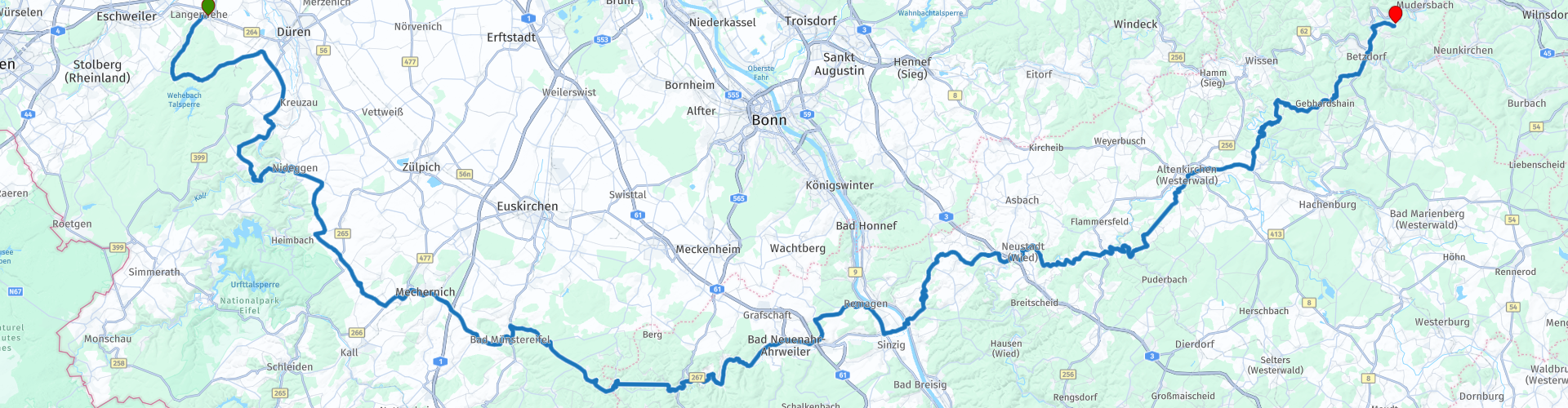
01 From Langerwehe to Kirchen via the Eifel and Westerwald

This route was brought to you by:
RouteXpert Leonor Orban - Sr. RouteXpert
Last edit: 03-11-2023
 Route Summary
 This ride is the 1st of 5 wonderful days of riding. On the first day (this ride) you travel straight through the Eifel to the Moselle and end in the Westerwald. Your day will be filled with a continuous stream of bends, views and of course the necessary terraces to enjoy a snack and a drink.
The route gets 5 stars: the beautiful steering roads combined with a wide range of cultural and historical sights (e.g. Bad Münstereifel, Radioteleskop Effelsberg, Burg Are, Museum Römervilla, Burgruine Ehrenstein) make this ride a real pleasure.
 Share this route


Animation

Verdict


Duration
7h 19m

Mode of travel
Car or motorcycle

Distance
212.27 km

Countries

 RouteXpert Review
 The starting point of the route is at the Karduck bakery in Langerwehe. This is a perfect starting point for travelers coming from far away: you can have a delicious (savory and sweet) breakfast here and drink a good cup of coffee. You can also quench your motorcycle's thirst: there is a gas station right next to the bakery.
You can start the route with a full belly and full of energy. And it starts well right away. You drive into the Meroder Wald, where you can relax your hips with a few first gentle bends. Not much later you can catch your breath by enjoying the view at the Obermaubach reservoir. The reservoir was built in the 1950s to manage water levels for the surrounding region. Today it is also a popular summer recreation area.
After this visit to the lake, a slow climb begins. You avoid the crowds at the Rursee by crossing the area on the east side. This part is quieter, perhaps less spectacular in bends, but the view of the Hahnenberg is all the more beautiful. At an altitude of 350 meters you have a wide panorama.
You continue the route via wooded areas towards Bad Münstereifel. Do you like shopping in a pleasant city center? Then it is worth taking a break here and looking around the many small boutiques. Of course there are also plenty of places to have a drink.
Travelers with other interests will also get their money's worth during this route. A little further along the route is Radioteleskop Effelsberg. Radio Teleskop Effelsberg was built in the period between 1968 and 1971. It has since been an important instrument for astronomical research (including the Milky Way, active galactic nuclei, and the study of cosmic magnetic fields) and has contributed to numerous discoveries in the radio astronomy. With its impressive satellite dish measuring 100 meters in diameter, it is one of the largest and most advanced radio telescopes in the world. From the parking lot you can walk to the telescope in a few minutes. There is also a small Imbiss near the parking lot where you can also take a break.
From the stars back to the earth and the forests. The route continues to wind its way through the forests until it reaches the Ahr river and the valley of the same name. Here the area is open and spacious again, partly because of the water. A devastating natural disaster occurred here in 2021: the river (and tributaries) overflowed its banks due to heavy rainfall over a prolonged period. The floods destroyed the entire area. Houses and roads were swept away. Here and there you see places where the local population is still busy with restoration work.
And yet it is good and worthwhile to visit this area. It has always been famous for its wine routes. There were – and still are – several wineries, cozy restaurants and hotels along the route. In addition, the nature here remains spectacular. Your route winds along the once terrifying river, past steep rocks and cliffs. And on those steep cliffs you occasionally find buildings from a different period. Burg Are, Saffenburg and Museum Römervilla to name a few.
Museum Römervilla is also easy to visit as a motorcyclist. You can park in an asphalted parking field across the road. From there you can walk to the entrance of the building in just a few minutes. The museum offers you a fascinating look at the region's Roman past. Located on the site of an ancient Roman villa, the museum displays an impressive collection of archaeological finds, including mosaics and utensils. It offers insight into the daily life of the Roman settlement in the Ahr Valley.
From here it is not far to the next impressive river. Where you could cross the Ahr river with bridges, you have to conquer the Rhine in this region via a ferry service. The crossing immediately gives you the opportunity to take some beautiful photos of the river. You can also briefly discuss with your fellow travelers whether you want to take a trip to Lienz am Rhein, on the other side of the river. The village dates back to Roman times and has a charming, traditional atmosphere. You can visit the old city wall and watchtowers, or the old toll house.
If you stay on the route (and skip a visit to the old center of Lienz), you can have lunch at Bakkerij Gilgen. This is still located in Lienz directly on the route. There are plenty of parking spaces right in front of the door and on hot days it is wonderful to relax in the bakery with air conditioning.
Once you leave Lienz you drive into the Westerwald. The first part is a lovely meander over smooth asphalt through the woods. Gradually the bends and roads become more gentle again: the day comes to an end... and a cooling beer or a refreshing drink awaits you at Hotel Zum Weissen Stein in Kirchen.
Time to end the day on the hotel terrace, looking back on a relaxing day of touring.


 Links
Links  Usage
Usage Want to download this route?
You can download the route for free without MyRoute-app account. To do so, open the route and click 'save as'. Want to edit this route?
No problem, start by opening the route. Follow the tutorial and create your personal MyRoute-app account. After registration, your trial starts automatically.  Disclaimer
Use of this GPS route is at your own expense and risk. The route has been carefully composed and checked by a MyRoute-app accredited RouteXpert for use on TomTom, Garmin and MyRoute-app Navigation.
Changes may nevertheless have occurred due to changed circumstances, road diversions or seasonal closures. We therefore recommend checking each route before use.
Preferably use the route track in your navigation system. More information about the use of MyRoute-app can be found on the website under 'Community' or 'Academy'.

North Rhine-Westphalia
About this region
North Rhine-Westphalia (German: Nordrhein-Westfalen, pronounced [ˌnɔʁtʁaɪn vɛstˈfaːlən] (listen); Low Franconian: Noordrien-Wesfale; Low German: Noordrhien-Westfalen; Colognian: Noodrhing-Wäßßfaale), commonly shortened to NRW (German: [ɛnʔɛʁˈveː] (listen)), is a German state (Land) in Western Germany. With more than 17.9 million inhabitants, it is the most populous state of Germany. Covering an area of 34,084 square kilometres (13,160 sq mi), it is the fourth-largest German state by size. Apart from the city-states, it is also the most densely populated state in Germany.
North Rhine-Westphalia features 30 of the 81 German municipalities with over 100,000 inhabitants, including Cologne (over 1 million), the state capital Düsseldorf, Dortmund and Essen (all about 600,000 inhabitants) and other cities predominantly located in the Rhine-Ruhr metropolitan area, the largest urban area in Germany and the third-largest on the European continent. The location of the Rhine-Ruhr at the heart of the European Blue Banana makes it well connected to other major European cities and metropolitan areas like the Randstad, the Flemish Diamond and the Frankfurt Rhine-Main Region.
North Rhine-Westphalia was established in 1946 after World War II from the Prussian provinces of Westphalia and the northern part of Rhine Province (North Rhine), and the Free State of Lippe by the British military administration in Allied-occupied Germany and became a state of the Federal Republic of Germany in 1949. The city of Bonn served as the federal capital until the reunification of Germany in 1990 and as the seat of government until 1999.
Culturally, North Rhine-Westphalia is not a uniform area; there are significant differences, especially in traditional customs, between the Rhineland region on the one hand and the regions of Westphalia and Lippe on the other. The state has always been Germany's powerhouse with the largest economy among the German states by GDP figures.
Read more on Wikipedia
North Rhine-Westphalia features 30 of the 81 German municipalities with over 100,000 inhabitants, including Cologne (over 1 million), the state capital Düsseldorf, Dortmund and Essen (all about 600,000 inhabitants) and other cities predominantly located in the Rhine-Ruhr metropolitan area, the largest urban area in Germany and the third-largest on the European continent. The location of the Rhine-Ruhr at the heart of the European Blue Banana makes it well connected to other major European cities and metropolitan areas like the Randstad, the Flemish Diamond and the Frankfurt Rhine-Main Region.
North Rhine-Westphalia was established in 1946 after World War II from the Prussian provinces of Westphalia and the northern part of Rhine Province (North Rhine), and the Free State of Lippe by the British military administration in Allied-occupied Germany and became a state of the Federal Republic of Germany in 1949. The city of Bonn served as the federal capital until the reunification of Germany in 1990 and as the seat of government until 1999.
Culturally, North Rhine-Westphalia is not a uniform area; there are significant differences, especially in traditional customs, between the Rhineland region on the one hand and the regions of Westphalia and Lippe on the other. The state has always been Germany's powerhouse with the largest economy among the German states by GDP figures.
View region
 Statistics
  136
136Amount of RX reviews (North Rhine-Westphalia)
 61487
61487Amount of visitors (North Rhine-Westphalia)
 27709
27709Amount of downloads (North Rhine-Westphalia)
 Route Collections in this region
 The 10 most beautiful car and motorcycle routes in Limburg
Limburg, who thinks of Limburg, thinks of flan, coal mines, marl and the hill country. The coal mines have been closed for almost 40 years, the last load of coal was brought up from the Oranje-Nassau coal mine in Heerlen on 31 December and, as they say, South Limburg was transformed from Black to Green and unfortunately there is still little left. view of this period.
But not only pie, marl and coal in Limburg, but also a very beautiful province to tour by car or motorcycle and enjoy all the beauty that the province of Limburg has to offer. For this, the MyRoute app RouteXpert has put together a Top 10 of Car and Motorcycle routes for you.
All routes in this collection have been checked and made equal for TomTom, Garmin and MyRoute-app Navigation by a MyRoute-app RouteXpert.
If you think, I have a very nice route that should certainly not be missing from this collection, send it to:
email: routeexpert@myrouteapp.com
Subject: New Route for the Top 10 collection Province of Limburg composed by Hans van de Ven.
The route will then be reviewed and then added to the Top 10.
To make the Top 10 also the Top 10, 1 route will have to disappear from the Top 10, you can indicate this when submitting the new route.
Have fun with this collection and while driving one of these routes. Enjoy all the beauty that the Netherlands and in particular the province of Limburg has to offer. Click on “View route” to read the review of the chosen route.
I would like to hear your findings about the route(s).
View Route Collection
Top 5 Car and Motorcycle Routes in the Eifel
The Eifel is the eastern part of the medium plateau Eifel-Ardennes. It is located north of the Moselle and west of the Rhine. The largest part is in Germany, a small part is in Belgium, in the East Cantons. The German part of Eifel is located in the federal states of North Rhine-Westphalia and Rhineland-Palatinate. The highest point is the Hohe Acht with 747 meters.
Several chains can be distinguished in the Eifel:
The northernmost part is called the Nordeifel, which in Belgium connects to the High Fens;
To the east of this is the Ahrgebirge, this part is located north of the Ahr in the Ahrweiler district;
South of the Ahr is the Hohe Eifel (or Hocheifel), of which the Hohe Acht (747 m) is the highest point, and also the highest point in the entire Eifel region;
To the west, near the Belgian border, the hills are known as Schneifel, part of the wider Snow Eifel area with peaks reaching up to 698 metres;
South and east of the Hohe Eifel is the Volcano-Eifel, a volcanic area with many crater lakes (Maare).
The southern part of the Eifel is less high. The area is bisected by streams and rivers running southwards. These streams flow into the Moselle. The largest of these rivers is the Kyll; the hills around this river are known as the Kyllwald;
In the south, the Eifel ends in the Voreifel.
In the north of the Eifel there are some large reservoirs. The largest of these is the reservoir in the Roer that was created by the construction of the Roerdal dam.
The Nürburgring is also located in the Eifel, a well-known car circuit for Formula 1 races, among other things. Since 2004, part of the north of the Eifel has become the Eifel National Park. This National Park falls entirely within the German-Belgian nature park High Fens-Eifel. Another part of the Eifel falls within the South Eifel Nature Park.
Well-known throughout the Netherlands and Belgium by car and motorcyclists, so reason enough for the MyRoute app RouteXpert to compile a Top 5 of Car and Motorbike routes for you.
All routes in this collection have been checked and made equal for TomTom, Garmin and MyRoute-app Navigation by a MyRoute-app RouteXpert.
If you think, I have a very nice route that should certainly not be missing from this collection, send it to:
email: routeexpert@myrouteapp.com
Subject: New Route for the Top 5 collection Eifel composed by Hans van de Ven.
The route will then be reviewed and then added to the Top 5. To make the Top 5 also the Top 5, 1 route will have to disappear from the Top 5, you can indicate this when submitting the new route.
Have fun with this collection and while driving one of these routes. Enjoy all the beauty that the Eifel has to offer. Click on “View route” to read the review of the chosen route.
I would like to hear your findings about the route(s).
View Route Collection