Defence Line of Amsterdam

This route was brought to you by:
RouteXpert René Plücken (MRA Master)
Last edit: 16-04-2025
 Route Summary
 The route is definitely worth 5 stars because of the beautiful winding dikes and Dutch heritage!
 Share this route


Animation

Verdict


Duration
9h 30m

Mode of travel
Car or motorcycle

Distance
166.24 km

Countries

 RouteXpert Review
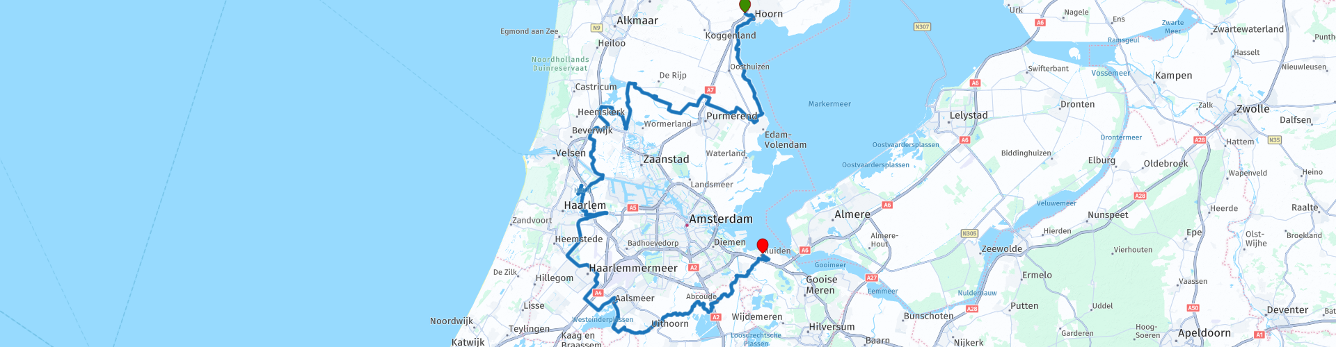
 The Defence Line of Amsterdam was a defence line, located 15 to 20 kilometres around the centre of the Dutch city of Amsterdam. The Defence Line is 135 kilometres long, contains 45 forts and was built from 1880 to 1920.
On 26 September 1995, the Defence Line of Amsterdam, together with the New Dutch Waterline, was submitted to UNESCO for inclusion on the World Heritage List, where it was placed in its entirety in 1996. In 2021, the New Dutch Waterline was added to the existing World Heritage. Both components have since been on the list under the name Dutch Water Defence Line.
The Defence Line of Amsterdam was primarily a waterline. In the event of hostilities, large parts of the area around Amsterdam would be flooded. The enemy would then not be able to advance. Amsterdam would function as the last bastion of the Netherlands. The construction of the Defence Line of Amsterdam was regulated in the Fortifications Act of 1874.
The forts were situated at places where the waterline was crossed by dikes, roads or railways. Places where the water was deep enough for boats were vulnerable, because the advancing enemy would not be stopped by the water at those places, so that he had to be able to come under fire at these places too. In military jargon, these roads etc. were known as accesses.
Enjoy this great ride of almost 170 kilometers, but because of the many sights you will be on the road all day, maybe even two days if you plan a lot of stops. You will ride on beautiful country roads, dikes and through beautiful villages in the provinces of North Holland and Utrecht. Along the route there are several options to stop for a drink or something to eat, there are some suggestions included in the route.
Not all forts are clearly visible from the road, so if you want to visit the forts, prepare your trip well and adjust the route to your liking. The links in this review provide more information about the sights along the route and which forts are open to the public, or whether there are guided tours. The highlight of this trip is the beautiful Muiderslot.
List of sights;
Fort Edam
Fort Kwadijk
Fort on the Nekkerweg
Fort on the Middenweg
Fort on the Jisperweg
Fort at Spijkerboor
Fort at Markenbinnen
Fort Krommeniedijk
Fort aan den Ham
Secondary battery at Fort aan den Ham
Fort at Veldhuis
Secondary battery at Fort near Veldhuis
Fort north of Spaarndam
Fort south of Spaarndam
Fort at the Liebrug
Fort near Vijfhuizen
Battery on the Sloterweg
Crash Air War and Resistance Museum
Aalsmeer Station and an Old Locomotive
Water tower near Aalsmeer
Fort at Kudelstaart
Fort Uithoorn and Pancake House
Fort Wavers Amstel
Fort in the Botshol
Fort at the Shop
Batteries on the Gein (on both sides of the road near the mill
Mouse Fort
Muiderslot
Pampus
Some suggestions of where to stop are;
1. The Fort at Edam, this is small and atmospheric.
2. Fort at Spijkerboor, this is a large one where guided tours are also given
3. Fort at Marken-Binnen, this is a beautifully situated fort in a quiet area.
4. Fort aan den Ham, here is also an educational centre
5. The town of Weesp with its fortifications and old centre is a nice option for a bite to eat towards the end of the ride or at the end of the ride in Muiderberg.
6. Muiderslot and the fortress island Pampus in Muiderberg. Definitely worth a visit to end this beautiful day.


 Links
Links  Usage
Usage Want to download this route?
You can download the route for free without MyRoute-app account. To do so, open the route and click 'save as'. Want to edit this route?
No problem, start by opening the route. Follow the tutorial and create your personal MyRoute-app account. After registration, your trial starts automatically.  Disclaimer
Use of this GPS route is at your own expense and risk. The route has been carefully composed and checked by a MyRoute-app accredited RouteXpert for use on TomTom, Garmin and MyRoute-app Navigation.
Changes may nevertheless have occurred due to changed circumstances, road diversions or seasonal closures. We therefore recommend checking each route before use.
Preferably use the route track in your navigation system. More information about the use of MyRoute-app can be found on the website under 'Community' or 'Academy'.