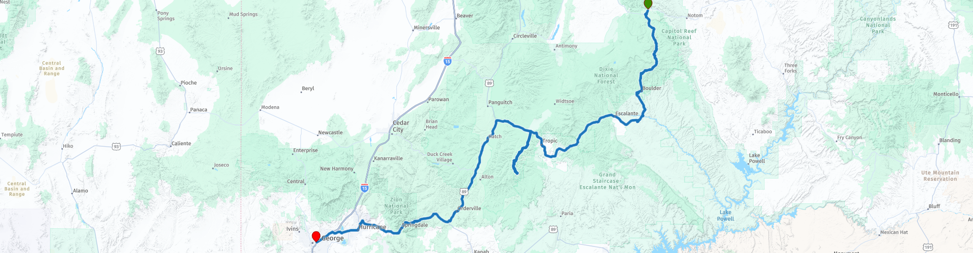
R07 Torrey St George

This route was brought to you by:
RouteXpert Hans van de Ven (Mr.MRA)
Last edit: 11-01-2020
 Route Summary
 This route is similar to the previous route, you go all the way through two well-known parks, Zion National Park and Bryce National Park, so that again guarantees the necessary stops to take photos.
During this journey you will travel through the following states: California, Arizona, Utah & Nevada.
The roads are good, the views amazing. Another day to leave early, so much to see. Don't forget your camera and your water!
Starting point: Capitol Reef Resort.
End point: Ramada Inn.
The route has been made the same for TomTom, Garmin and MyRoute-app Navigation users.
Thanks to Richard & Lisa for the information!
 Share this route


Animation

Verdict


Duration
6h 38m

Mode of travel
Car or motorcycle

Distance
442.33 km

Countries

 RouteXpert Review
 In this 4-star route you mainly drive on good roads, a long drive, but a stop in Bryce National Park and Zion National Park you should definitely do, so many endless views. Also bring enough water again!
General information:
Bryce canyon
Bryce Canyon became a National Park in 1928 and covers approximately 145 km2. It is named after the Mormon family Bryce, who lived there between 1875 and 1880. Ebenezer Bryce worked on the accessibility of the area, among other things by constructing a road. Local people called the strange area near Bryce's house "Bryce's Canyon", a name that exists until today. The area that is now a National Park in Utah was formed between 144 and 63 million years ago. The rocks were formed by the constantly attacking and receding seawater (!) That then still reached this area. The red rocks, called "hoodoos", were formed between 66 and 40 million years ago when the highest parts of the area eroded and various sediments were deposited on the bottom of rivers and lakes. Bryce Canyon is more a large series of strange, naturally formed amphitheaters consisting of rocks than a ravine. Thousands of bizarre rock formations can be found in these amphitheaters, carved out over millions of years by the water. Columns, towers, raised points in many different colors characterize this area. The limestone formations in which they originated are the famous Pink Cliffs of the state of Utah. The beautiful and colorful shapes of this area are a feast for the eyes. The colors change constantly under the weather conditions. Visitors can reach almost the entire park by car and only have to walk to a viewpoint to admire this wonderful event. You can also make guided tours on foot or by horse in the park. Where one is guided by an experienced guide. You can also make the choice to enter the park on your own. The climate of Bryce Canyon in Utah is very varied. There may be snow from October to April (average snowfall is 2.5 meters per year); In the summer, the temperature during the day is around 30 C, but at night it can drop to around 7 degrees. Thunder storms often take place. It is advised to always wear a headgear and sunscreen in Bryce Canyon because of the sun.
Zion National Park
This beautiful park owes much of its appearance to the Virgin River. A large canyon, side gorges, rich vegetation, steep rock walls and deep canyons are the ingredients of this area. The park got its status in 1919 and it covers an area of 592 square kilometers. The most important feature, and also the main attraction, is Zion Canyon. A 24 km long and 800 meter deep colorful canyon. Zion, which has been a National Park since 1919, consists of nearly 600 km2 of rocks and canyons. The name comes from the Mormons, the first whites who discovered the park; "Zion" refers to a safe place. In Zion NP there are more than 800 plant species as well as 380 different animal species (including 271 bird species). The area that now includes Zion NP is more than 250 million years old, when huge volcanic eruptions began to form the area. There were also dinosaurs at the time, of which fossils can still be found today. The rocks in the area were formed from compressed sand about 150 million years ago; the gorges that can be found in Zion were carved out of the sandstone after the Virgin River flooded about 4 million years ago. The water has since slowly but surely worn away the rocks, creating the well-known gorges. The first indications of human habitation date from around 7,000 years ago. The Anasazi Pueblo Indians then inhabited the area from about 2,500 years ago to 1150 AD. Chr., Followed by the Paiutes, who inhabited the area when the first whites visited him around 1860. Although illnesses reduce their numbers drastically, they can still be found in the Zion NP area to this day. The vast majority of the rock formations can be seen from the road, but it is certainly not unwise to make a trip so that you can see more of the park. Taking walks assures the walker of beautiful views of some of the park's more hidden beauties. It is wise to follow the Zion Scenic Drive if you are going to see the park by car. A beautiful ride through Zion canyon is then a fact.
Lower, Middle and Upper Emerald Pools Trail
At the Zion Lodge you can cross the Virgin River via a bridge. Immediately after the bridge, the path divides, right into the Lower Emerald Pools, and left into the Middle Emerald Pools. Length Lower Emerald Pool Trail: 1.9 kilometers (round trip) Height difference Lower Emerald Pool Trail: 21 meters The walk to the Lower Emerald Pool is very easy. The path is paved and runs through a shady area with many plants and trees. After a little less than 1 kilometer there is a small waterfall; the water falls down here from the top of an overhanging rock. It ends up in the small pond of the Lower Emerald Pool, just below the path. You can walk behind the waterfall; the path here is a bit slippery because of the drifting water. If you only want to see the Lower Emerald Pool, return from here via the same path. Length Middle Emerald Pool Trail: 2.7 or 3.2 kilometers (round trip) Height difference Middle Emerald Pool Trail: 46 meters The Middle Emerald Pool is 25 meters higher than the Lower Emerald Pool. There are two different paths to this small pond. You can first go to the Lower Emerald Pool, and - after walking under the waterfall - climb up a 400 meter long rocky path. Steps have been carved into the rocks at various places. The area here is much less green than around the Lower Emerald Pool Trail. You can also skip the Lower Emerald Pool. Then at the start of the walk - immediately past the Virgin River - take the left turn. This Middle Emerald Pool Trail is 1.6 kilometers long, and much steeper than the Lower Emerald Pool Trail. You climb 46 meters up here over a mainly sandy surface. As you get closer to the water hole, the path becomes a bit more rocky. From the Middle Emerald Pool you have a very nice view over the southern half of Zion Canyon. Length of the Upper Emerald Pool Trail: 1.6 kilometers (round trip) Height difference Upper Emerald Pool Trail: 61 meters The trail starts at the Middle Emerald Pool; for the total length and the total height difference you must therefore add the data from the Middle Emerald Pool Trail. Upper Emerald Pool is the largest of the three ponds. The mountain lake is sandwiched between a rock face and a small sandy beach with many boulders and plants around it. A small veil-like waterfall can be seen during the winter and spring months; the water falls down from the top of the rock face and ends up in the Upper Emerald Pool. The Upper Emerald Pool Trail is an 800-meter long trail that is dotted with boulders. You climb 61 meters up through those boulders. You can only return via the same path.


 Links
Links  Usage
Usage Want to download this route?
You can download the route for free without MyRoute-app account. To do so, open the route and click 'save as'. Want to edit this route?
No problem, start by opening the route. Follow the tutorial and create your personal MyRoute-app account. After registration, your trial starts automatically.  Disclaimer
Use of this GPS route is at your own expense and risk. The route has been carefully composed and checked by a MyRoute-app accredited RouteXpert for use on TomTom, Garmin and MyRoute-app Navigation.
Changes may nevertheless have occurred due to changed circumstances, road diversions or seasonal closures. We therefore recommend checking each route before use.
Preferably use the route track in your navigation system. More information about the use of MyRoute-app can be found on the website under 'Community' or 'Academy'.