van Oberried naar Rotttach Egern via Deutsche Alpenstrasse

This route was brought to you by:
RouteXpert Eric Wilderbeek
Last edit: 02-09-2021
 Route Summary
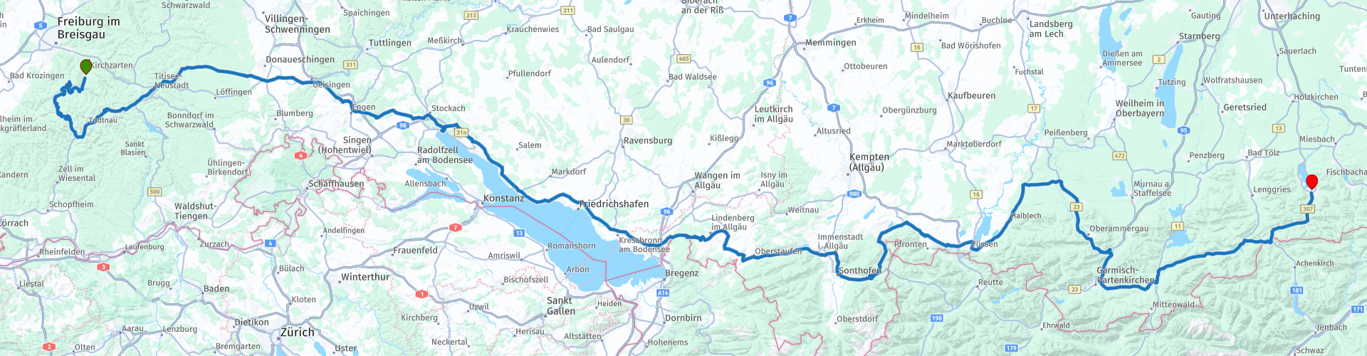
 The day starts with lovely curves in the Black Forest, so you can start steering right after the start.
Then we drive inland to Lake Constance, which you pass on the north side.
After Lake Constance you clearly arrive in a more mountainous area and you also get a number of passes under the wheels. This part is part of the Deutsche Alpenstrasse.
This route gets 5 stars from me because of:
The wonderful mountain roads that you continue to encounter during the entire route. The roads are very easy to drive and well maintained. The crowds on the road are, apart from a number of cities you drive through, fairly quiet to quiet even.
The views are beautiful and the landscape changes from hilly to mountainous.
 Share this route


Animation

Verdict


Duration
11h 8m

Mode of travel
Car or motorcycle

Distance
464.57 km

Countries


 RouteXpert Review
 This route takes you along the southern border of Germany from the Black Forest via much of the Deutsche Alpenstrasse to the foot of the Alps.
The day starts with lovely curves in the Black Forest, so you can start steering right after the start. We take a part of the well-known Schauinsland route. Please note that the Schauinsland route is closed to motorcyclists on weekends and public holidays between April 1 and November 1. We still take the Wiedener Eck and Feldberpass before we leave the Black Forest via Titisee.
Lake Titisee extends over an area of 1.3 km² and has an average depth of 20 meters. The lake was created by the Feldberg Glacier, whose moraines formed in the Pleistocene now border the present shore. The outflow of the lake, at 840 meters above sea level, is the Wutach River. On the north bank is the spa of the same name, today part of the town of Titisee-Neustadt
We drive inland to Lake Constance. This runs fairly smoothly and the landscape is undulating and you can drive on nicely. We drive the entire route along / on the watershed border of the Rhine and Danube. The watershed runs through the foothills of the Alps north of the Schussen basin to the sources of the Brigach and Breg (sources of the Danube) in the Black Forest. It is expected that in the distant future the watershed between Rhine and Danube will shift eastwards due to stream decapitation, whereby areas that previously drained to the Danube will drain to the Rhine. This is due to the steeper profile of the Rhine compared to the Danube.
After the Black Forest, the European watershed follows the main ridge of the Swabian Alb and the Fränkische Alb. The height of the European watershed crosses the Rhine-Main-Danube Canal at Hilpoltstein at an elevation of about 400 meters, after which the watershed continues through the Fichtel Mountains and south-east along the Bohemian Forest, where the watershed forms the border between Germany and Austria on the one hand and the Czech Republic on the other hand.
As soon as you arrive at Lake Constance you can get a delicious coffee in Ludwigshafen on the edge of the lake. There is a parking lot right on the lake. The view over the lake is a taste of the rest of the day, which includes lakes, rivers and mountain peaks.
We pass the Bodensee on the north side and you clearly arrive in a more mountainous area and you also get a number of passes under the wheels. This part is part of the Deutsche Alpenstrasse. The Deutsche Alpenstrasse runs through the popular holiday regions of Allgäu and Oberbayern. If you drive the Alpenstrasse in several days, take the time for a rest with panoramic mountain views, for a swim in one of the invigorating, clear lakes, a hike on an alm and a stopover with tasty sandwiches. Get to know the towns and cities where there is always something to do. Visit one of the many traditional festivals or relax in the silence of the Baroque monasteries.
At Oberjoch you can take the Oberjoch pass to Austria to the right and pick up the route again via Tannheim, Pfronten and Fussen.
You will notice that on the right you have the foothills of the Alps where you can already see considerable mountain peaks that, depending on the season in which you drive the route, can be snowy.
We stop the route in Rottach Egern on the Tegernsee. The municipality of Rottach-Egern has 5,779 inhabitants and is known as a luxurious holiday resort. There are several hotels along the lake.


 Links
Links  Usage
Usage Want to download this route?
You can download the route for free without MyRoute-app account. To do so, open the route and click 'save as'. Want to edit this route?
No problem, start by opening the route. Follow the tutorial and create your personal MyRoute-app account. After registration, your trial starts automatically.  Disclaimer
Use of this GPS route is at your own expense and risk. The route has been carefully composed and checked by a MyRoute-app accredited RouteXpert for use on TomTom, Garmin and MyRoute-app Navigation.
Changes may nevertheless have occurred due to changed circumstances, road diversions or seasonal closures. We therefore recommend checking each route before use.
Preferably use the route track in your navigation system. More information about the use of MyRoute-app can be found on the website under 'Community' or 'Academy'.