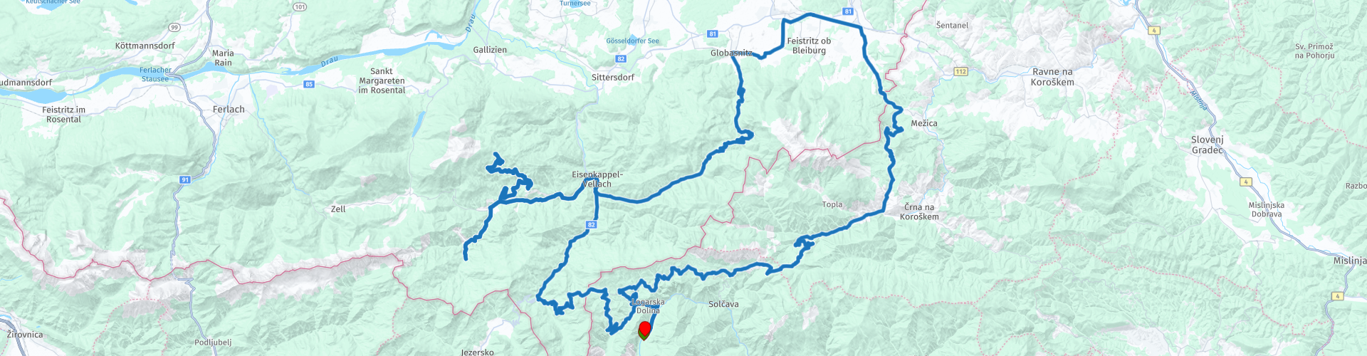
Rondrit Logarska Dolina via Trogerner Klamm en de Luschasattel

This route was brought to you by:
RouteXpert Leonor Orban - Sr. RouteXpert
Last edit: 16-04-2023
 Route Summary
 The list includes Logarska Dolina, Trögerner Klamm, Hochobir, Luschasattel and Spodnje Sleme. Even if these names don't sound familiar to you, they promise a wonderful ride.
The breaks and sights along the route are mainly small local family businesses this time. On the small mountain roads you will come across picturesque mountain huts with tasty local dishes. And the sights are also local: a modest pilgrim museum and an exuberant work of art by a local artist.
The route gets 4 stars. The landscape is fantastic, the bends countless. And with a bit of luck you will have little traffic. A number of roads have bad road surfaces; sometimes asphalt is missing. Hence not the full 5 stars.
 Share this route


Animation

Verdict


Duration
8h 24m

Mode of travel
Car or motorcycle

Distance
163.01 km

Countries


 RouteXpert Review
 Because the route is not that long, you can start the morning quietly at your overnight stay in Logarska Dolina. Enjoy the peace in the valley for a while, because – as soon as you start the route – it is over.
Immediately after you leave Logarska Dolina you take the main road towards the Paulitschsattel and the border crossing from Slovenia to Austria. Before you start the steep climb, you can first drive a nice loop on a gravel road. This hidden piece of road leads you through the dense forest and a number of farms. Eventually you will reach the main road again and wind into Austria. The old customs house is still there, as a reminder of the border.
The route then goes downhill towards Bad Eisenkappel, where you can refuel if necessary. Keep in mind that there are not many gas stations along the route. You can possibly refuel when you return to this village: You will return here in about 50 kilometers.
From the village you drive west. First you drive into the Trögerner Klamm. This narrow gorge was created because the Trögernbach river has carved a path into the limestone over the years. If you look closely, there could even be traces of an ancient sea.
Check the sign at the beginning of the canyon. If all goes well, there will still be a friendly request to visit the gorge preferably on foot or by bicycle, but it will not be a prohibition sign. In that case you can safely drive into the gorge. Take your time to look around and enjoy the views. At the end of the gorge you will find a small mountain hut. As the name of the restaurant promises (for body and soul) you can enjoy delicious food and drinks here. With renewed energy you can start the rest of the route.
Once out of the gorge, you can drive the Hochobir Panorama Road. This narrow mountain pass ends at the Eisenkappler Hütte, where you have a reasonable view of the valley where you started the climb. Keep in mind that you have to pay a toll for this road. The road surface is poor and can present a tough challenge for inexperienced riders.
After the two dead ends, you continue the tour. After Bad Eisenkappel, the ascent to the Luschasattel begins. This modest mountain pass takes you to an altitude of about 1,300 meters. The height is not spectacular, the road all the more so. It is a beautiful little Alpine mountain road. It slopes up the mountain. Tight hairpin bends are interspersed with beautiful views. Farms are scattered along the route. Some of these farms are now guesthouses, so you can take a break here and enjoy lunch if you haven't already had one.
You can also visit the farm of the Peršman family on the Luschasattel. This place is now a museum. At the end of WWII (April 25, 1945) SS troops killed 11 people (including children) here and set fire to all buildings. Although the cases went to trial after the war, no one was ever convicted.
At the bottom of the Luschasattel in Globasnitz you have Elberstein Castle and the Pilgrim Museum. You can hardly miss the castle, with all its splendor. A local artist started building the castle in 1976 and has not stopped since. Everything you see (inside and outside) comes from his hand. In the summer months you can visit his life's work. Entrance is at your own discretion. At the entrance there is a scale where you can make a donation. You will also find the pilgrim museum here in the village. Traces from 400 AD of an early Christian church complex with mosaic floors have been found on the nearby Hemmaberg. Excavations clearly show that large groups of pilgrims came here.
From Globasnitz you have a less exciting part of the route. The border to Slovenia must be crossed again via a through road. Fortunately, once you cross the border, you can quickly find the winding roads again.
Via hairpin bends you descend to the valley of Podpeca and Koprivna, where you can have another break at a local restaurant. Here you can drink a cool drink in the shade of the trees.
A little later you make the climb to Spodnje Sleme. The road leads you to an altitude of 1254 meters. The route winds along the mountain ridge, back towards Logarska Dolina. Take a moment to stop at the viewpoints along the route. At the second marked spot, you can see your hotel in a clear view in the valley of Logarska Dolina.
Finally, you descend back to the valley and hopefully end a beautiful sunny day on the terrace at your hotel.


 Links
Links  Usage
Usage Want to download this route?
You can download the route for free without MyRoute-app account. To do so, open the route and click 'save as'. Want to edit this route?
No problem, start by opening the route. Follow the tutorial and create your personal MyRoute-app account. After registration, your trial starts automatically.  Disclaimer
Use of this GPS route is at your own expense and risk. The route has been carefully composed and checked by a MyRoute-app accredited RouteXpert for use on TomTom, Garmin and MyRoute-app Navigation.
Changes may nevertheless have occurred due to changed circumstances, road diversions or seasonal closures. We therefore recommend checking each route before use.
Preferably use the route track in your navigation system. More information about the use of MyRoute-app can be found on the website under 'Community' or 'Academy'.

Carinthia
About this region
Carinthia (German: Kärnten [ˈkɛʁntn̩] (listen); Slovene: Koroška [kɔˈɾóːʃka] (listen)) is the southernmost Austrian state or Land. Situated within the Eastern Alps, it is noted for its mountains and lakes. The main language is German. Its regional dialects belong to the Southern Bavarian group. Carinthian Slovene dialects, forms of a South Slavic language that predominated in the southeastern part of the region up to the first half of the 20th century, are now spoken by a small minority in the area.
Carinthia's main industries are tourism, electronics, engineering, forestry, and agriculture. The multinational corporations Philips, Infineon Technologies and Siemens have large operations there.
Read more on Wikipedia
Carinthia's main industries are tourism, electronics, engineering, forestry, and agriculture. The multinational corporations Philips, Infineon Technologies and Siemens have large operations there.
View region
 Statistics
  35
35Amount of RX reviews (Carinthia)
 35223
35223Amount of visitors (Carinthia)
 4801
4801Amount of downloads (Carinthia)
 Route Collections in this region
 The 24 Most Beautiful Alpine Routes
The Alps, The Alps are a mountain range in Europe, stretching from the French Mediterranean coast in the southwest to the Pannonian Plain in the east. The area of the mountain range is more than 200,000 km².
In other words Passes and Mountain Roads!
Driving through the mountains is great! Especially over the mountain passes with hairpin bends and narrow winding roads. Every bend a different view where you can enjoy. There are many beautiful mountain passes in the Alps.
A selection that has also been incorporated into these routes:
The Stlevio Pass:
The Stelvio Pass, also known as Passo dello Stelvio, is mainly known for the stage in the Giro d'Italia. Due to the length and the difference in height, this pass is seen as one of the toughest tests in cycling. The Stelvio Pass reaches a maximum height of 2758 meters and is therefore one of the highest in the Alps. The pass connects the towns of Bormio and Prato Allo Stelvio. In winter the pass is closed due to heavy snowfall.
The Reschenpass:
The Reschenpass, also known as Passo di Resia, connects the Austrian state of Tyrol with the Italian province of South Tyrol. The pass reaches a maximum height of 1,504 meters and has been one of the most important north-south connections in the Alps in recent centuries. The pass was used long before Roman times. Along the way you will pass several highlights and historical relics. One of the highlights is the Reschensee. This lake was created after the construction of the dam and has completely submerged the village of Graun. The only thing that reminds of that is the clock tower in the middle of the lake.
Col du Galibier:
The French mountain pass Col du Galibier connects the towns of Saint-Michel-de-Maurienne and Briançon via the Col du Lautaret in the south and the Col du Télégraphe in the north. The mountain pass is part of the Tour de France and very much feared, due to the fact that it can only be reached via the other two mountain passes. The pass reaches a maximum height of 2646 meters. From there you can take a walk to the viewpoint at 2704 meters. You can admire the peaks of the Grand Galibier, Mont Blanc and La Meije here.
The Grossglockner High Alpine Road:
With a height of 3798 meters the Grossglockner is the highest mountain in Austria. To fully enjoy this impressive mountain, you can drive over the Grossglockner High Alpine Road and the accompanying pass. The route starts from Bruck am Grossglockner and ends in Heiligenblut. Of course you can drive in two directions. The pass reaches a maximum height of 2504 meters and is closed in winter due to heavy snowfall. Along the way you pass several stops with fun activities, information points, mountain huts and viewpoints. A visit to the Kaiser-Franz-Josefs-Höhe and Pasterzen Glacier is highly recommended.
The Col d'Izoard:
Just like the Col du Galibier, the Col d'Izoard is also part of a stage of the Tour de France. The mountain pass connects Briançon with the valley of the river Guil. The pass is partly located in the Regional Natural Park du Queyras and reaches a maximum height of 2360 meters. What is special about the Col d'Izoard is the barren and rocky landscape. Sometimes it feels like driving a car over the moon! Along the way you can stop at several points to enjoy the beautiful view.
The Bernina Pass:
The Bernina Express is one of the most famous rail trains in Switzerland and the Alps. The route is beautiful and partly included on the UNESCO World Heritage List. Parallel to the railway lies the Bernina pass, which connects the Veltlin valley with the Egandin valley. This beautiful Alpine road has a total length of 56 kilometers and reaches a maximum height of 2328 meters. Along the way you can enjoy views of the Morteratsch Glacier.
The Sella Pass:
The Sella Pass, also known as Passo di Sella, takes you over one of the most impressive mountain ranges in the Dolomites: the Sella massif. The pass connects Valle di Fassa with Val Gardena and reaches a maximum height of 2236 meters. At this height is also the border of the Italian provinces of Trentino and Bolzano. Along the way you can enjoy the view of this spectacular mountain world. Admire, for example, the three peaks of the Sasso Lungo massif, the Sella massif or the peaks of the Marmolada. You can also drive the Sella pass in combination with the Gardena pass, Pordoi pass and Campolongo pass.
The Grimsel Pass:
The Grimsel Pass connects Goms in Wallis with the Halis Valley in the Bernese Oberland. The pass reaches a maximum elevation of 2165 meters and is closed in winter due to snowfall. Over the centuries, the mountain pass has played an important role in trade between Switzerland and Italy. Now it is mainly the reservoirs that have an important function. These are used to generate electricity. The landscape you drive through is rugged, rocky and impressive. On top of the pass is a hotel and a restaurant with a special marmot park. The Dodensee (Totensee) is also located here. This lake owes its name to the many soldiers who died in the time of Napoleon.
The Gotthard Pass:
The Gotthard Pass, also known as Passo del San Gottardo and Saint Gotthard, connects the Swiss towns of Airolo and Andermatt. The mountain pass and associated tunnel are especially known among holidaymakers driving from Switzerland to Italy. But where the majority opt for the tunnel, it is precisely the pass that really completes the holiday. The Gotthard Pass has a length of about 26 kilometers and reaches a maximum height of 2106 meters. The route is beautiful and takes you along old villages and beautiful views.
The Silvretta High Alpine Road and Silvretta Pass:
The Paznaun Valley in Tyrol and the Montafon in Vorarlberg are connected by the Silvretta High Alpine Road. The route has a length of 22.3 kilometers and leads from Galtür to Partenen in 34 hairpin bends, via the 2032 meter high Bielerhöhe. The Silvrettasee is also located at this point, where you can enjoy a lovely walk. The pass is closed in winter due to snowfall.
The Simplon Pass:
Just like the Gotthard Pass, many holidaymakers also travel over the Simplon Pass every year. This mountain pass connects the Rhone Valley in the canton of Valais with the Valle d'Ossola in Piemonte. The pass is open all year round and reaches a maximum height of 2005 meters. Along the way you pass a number of buildings, including the well-known Simplon Hospiz from 1825. The hospiz is managed by the monks of St. Bernard. From the highest point on the pass, all kinds of hiking routes are possible and you will also come across a hotel where you can spend the night.
The Gerlos Pass:
The Gerlos Pass connects the Salzach Valley in the Salzburgerland with the Zillertal Valley in Tyrol. The pass is part of the Gerlos Alpenstraße and runs right through the Hohe Tauern National Park. Along the way you can enjoy beautiful views of the surroundings. The pass has a length of 12 kilometers and reaches a maximum height of 1531 meters. A ride over the Gerlos Pass can be ideally combined with a visit to the Krimmler Wasserfälle.
The Great St. Bernard Pass:
The Great St. Bernard Pass, better known as Col du Grand Saint Bernard, connects the Italian province of Valle d'Aosta with the Swiss canton of Valais. The pass is one of the highest in Switzerland and reaches a maximum height of 2469 meters. Like a number of other mountain passes in this list, the Great St. Bernard Pass has also been used as a connecting road for centuries. The pass is named after the St. Bernard dogs that used to help stranded travelers along with the monks. The pass is closed in winter.
The Timmelsjoch High Alpine Road:
The Timmelsjoch High Alpine Road connects the towns of Sölden in the Ötztal and Meran in South Tyrol. Tolls must be paid on the Hochgurgl - Moos route. Via a mountain road with about 60 hairpin bends you drive through a beautiful mountain world. With the Timmelsjoch Experience you can learn more about the history, the road and the environment via various stations. You can also visit the Top Mountain Crosspoint museum.
Col de l'Iseran:
With a maximum pass height of 2770 meters, the Col l'Iséran is one of the highest mountain passes in the Alps. The pass connects Bourg-Saint-Maurice with Bonneval-sur-Arc. Via a road full of hairpin bends you pass, among other things, Val-d'Isère and a side valley of the Maurienne that lies entirely in the National Park de la Vanoise. You can spot animals such as marmots and chamois and there is also a restaurant with a chapel on top of the pass.
The Gavia Pass:
The Gavia Pass (Italian Passo di Gavia) is a mountain pass in the Italian Alps, in the Lombardy region.
It is one of the highest pass roads in Europe. The road leads through the unspoilt Stelvio National Park. The road was built in the First World War to supply Italian soldiers who fought in the Italian-Austrian border area. The pass height is one of the most beautiful in the Alps. Here is the large Lago Bianco with, to the north, the mountain San Matteo (3684 meters). Lago Nero is slightly lower on the south side of the pass. Here the mountain group of the Adamello determines the view. There are many well-marked walks in the area. During the winter the pass is closed due to the heavy snowfall. The pass is often closed until May and June due to the large amount of snow.
Promoter has made a selection of the 24 Most Beautiful Alpine routes that they have set out in recent years.
The routes go through:
France
Austria
Switzerland
Italy
The most beautiful roads, the most beautiful views, the most beautiful viewpoints. The highest mountains, the fastest descents, hairpin bend after hairpin bend, you name it you can't get enough of it.
If you go on holiday in this region, take advantage of it, ALL routes in this collection have been checked and made equal for TomTom, Garmin and MyRoute-app Navigation by a MyRoute-app RouteXpert.
Have fun with this collection and while driving one of these routes. Enjoy all the beauty that the Alps and the Dolomites have to offer. Click on “View route” to read the review of the chosen route.
I would like to hear your findings about the route(s).
View Route Collection
The 12 most beautiful car and motorcycle routes in Carinthia
“Motorradland Kärnten” where you feel so wonderfully welcome as a motorcyclist!
Own website for motorcyclists, own curated routes, hotels, campsites and guest houses with attention for motorcyclists, a wonderful area where motorcyclists are very popular.
Kärnten or Carinthia, at the crossroads of the Germanic, Slavic and Roman worlds. Three cultures within a few kilometres, southern flair, culinary delights, cross-border tours. Breakfast in Italy, lunch in Slovenia, dinner in Austria - all in one day. Experience the diversity in the borderless Alps-Adriatic region, the area for motorcyclists.
Extensive day trips on winding mountain paths, romantic panoramic routes and beautiful lakes, here the 12 TOP routes Kärnten / Carinthia. Enjoy!
View Route Collection