Bern Schwarzsee Gurnigel Schallenberg Thun

This route was brought to you by:
RouteXpert Aendu (Andreas) Lenz
Last edit: 04-11-2023
 Route Summary
 Highlights:
-Lots and lots of curves, hill climbs
-Fantastic view of the Bernese mountains and Lake Thun, west to the Jura (border mountains between Switzerland and France) and the 3 lakes (Murten-Biel-Neuchâtel).
-Vehicle/Driver:
Motorcycle, only drivers with experience (comfortable and/or sporty driving) The requirements for the driver: - high. What is required on the mountain is driving technique and concentration. (car possible)
-Roads: Quality good to very good. Mostly 2 lanes. Around 30 kilometers are slightly narrower roads.
Since not every good route can receive 5 stars, I give this route 4 stars. Since depending on the time of day there can be traffic congestion when driving through Thun, 5 stars are too much.
 Share this route


Animation

Verdict


Duration
7h 0m

Mode of travel
Car or motorcycle

Distance
233.78 km

Countries

 RouteXpert Review
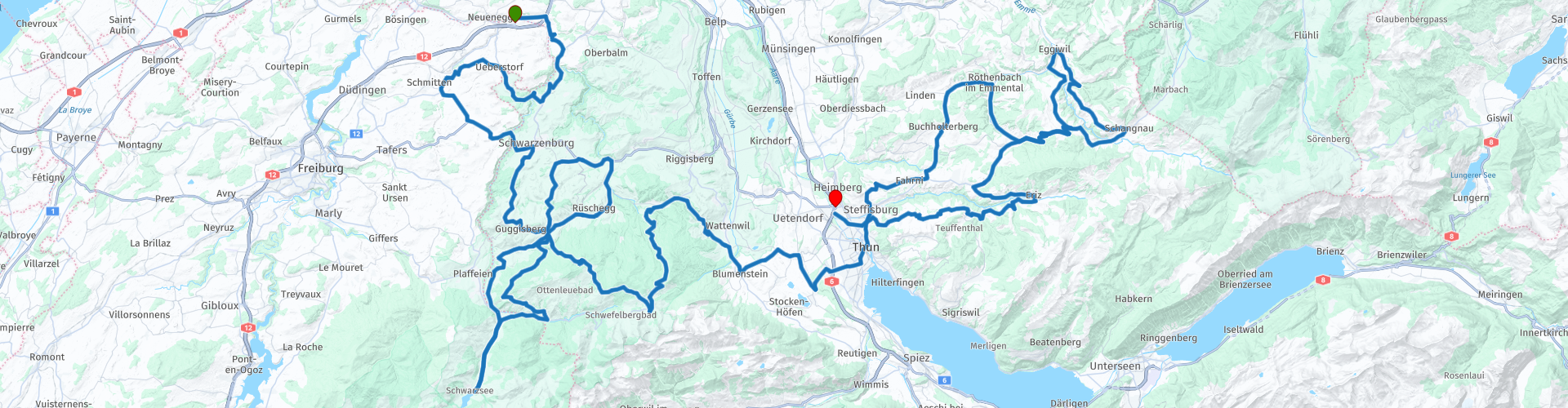
 -First we drive towards “Schwarzenburg”. You can already benefit from my insider knowledge. We don't drive directly to “Schwarzenburg”, but rather cross the small river “Sense” 3 times and enjoy a few extra curves. Afterwards we drive towards “Schwarzsee”, again enjoying extra curves that I built into the route.
BLACK LAKE:
“Schwarzsee”, which is a child-friendly recreation and sports area in the city of “Freiburg”. In summer: summer tobogganing, scooter riding, paragliding, hiking... In winter: skiing, ski touring, night skiing, tobogganing (tobogganing). In the evening, eat a fondue in the mountain restaurant and then go sledding. As a rule, it is very cold in the “Schwarzssee” in winter, so the snow remains even at lower altitudes and does not melt away immediately. (See link)
-Here we take a short break. We enjoy a coffee in a restaurant by the lake (with a lake view). If you like it simple: in the Gybsera restaurant with self-service, or in the part with service. (or there are other options a few meters further on the right side of the street) Then we continue on our way to Gurnigel. After a short drive you will find the “Ice Palaces” on the right (of course only in winter). Shortly before “ Zollhaus ” we turn right and drive to “Sangerenboden”, here we turn left, the road becomes a bit bumpy. We pass the photo point, stop briefly and enjoy the view towards the “Jura”. Now follows a forest section that becomes even bumpier. Of course, an Enduro is an advantage.
-At “Riffenmatt” we turn right and begin the actual climb to Gurnigel.
RIFFENMAT:
The “Schafscheid” has taken place here on the first Thursday in September for 350 years. The sheep come back from the Alps and are returned to the owners. There are also around 200 market stalls.
GURNIGEL:
Swiss racing history. The oldest motorsport race in Europe takes place here; the first race was held in 1910. The race has taken place every year (in September) since 1968. Part of the pass road is closed this weekend. (See link)
There is also a motorcycle meeting on the “Gurnigel”. Every Tuesday from 5:30 p.m., from May to September, at the “unteren Gantrischhütte”. This is where people make contacts and talk shop over bratwurst and something liquid.
-After we have driven down the “Gurnigel”, we turn right onto a narrow street. On the way to “Blumenstein” we have a beautiful view towards “Thun” of the lake and the mountains. Shortly afterwards we turn sharp right. Steep narrow road to “Blumenstein”. Now we traverse via Thun to the “Schallenberg”.
THUN:
“Thun”, the gateway to the Bernese Oberland, has a lot to ask for. Thun Castle was built in the 12th century. From up here you have a wonderful view of the 3 well-known mountains. Eiger, Mönch, Jungfrau (Top of Europe)
“Thun” with the lake and the mountains, a great constellation. This is probably why Thun feels so pleasant (human). The residents are friendly and easy to get along with. The old town is perfect for strolling and shopping. A sidewalk that is partly 2 meters above the street. (I've never seen that before) In any case, “Tun” is worth a trip. “Thun” is virtually free of traffic lights; occasionally traffic cadets are on site and regulate the traffic.
-In “Steffisburg” we turn left. Again we take a different route than most would take. In “Jassbach” we turn right. Interim information: on the left is “Linden”, from here comes **Thomas Lüthi** the Swiss motorcycle racer (2005 world championship title with 125ccm)
-We now reach the Schallenberg, high time for a break. Lunch????? Restaurant “Gabelsspitz” Warm food on Sundays 11:30 a.m. to 7:30 p.m. (as of 2023)
SCHALLENBERG:
Töfftreff, every Friday from 5:00 p.m., from the end of April to the end of September. (See link)
-We continue, downhill.
-------(ATTENTION when we are in the colder season, there is a place that quickly forms black ice. This point is marked on the route, left curve at the edge of the forest. )------
-we now drive until just before “Schangnau” and then turn left. Now it becomes narrow again and the driver is also challenged with confusing curves. So it's a comfortable ride here. In “Eggiwil” we turn left and find ourselves on a 2-lane road for a short Monet.
-We turn right and drive over the “Kapf” (cars can still barely cross). After around 12 kilometers we turn right towards “Aeschau”. We drive quickly on the 2-lane road to “Eggiwil”. The road looks familiar to us.
-A short while later, turn left again. Aha! Things are going uphill again. We quickly drive up the next curves. We now approach the “Schallenberg” from the other side. (It was so beautiful, so now also from this side) After the best section, we turn right at “Oberei bei Süderen”. We drive via “Steffisburg” towards “Sehaften” and then on towards “Thun”. Our goal.
The route can also be easily driven from the destination to the start.


 Links
Links  Usage
Usage Want to download this route?
You can download the route for free without MyRoute-app account. To do so, open the route and click 'save as'. Want to edit this route?
No problem, start by opening the route. Follow the tutorial and create your personal MyRoute-app account. After registration, your trial starts automatically.  Disclaimer
Use of this GPS route is at your own expense and risk. The route has been carefully composed and checked by a MyRoute-app accredited RouteXpert for use on TomTom, Garmin and MyRoute-app Navigation.
Changes may nevertheless have occurred due to changed circumstances, road diversions or seasonal closures. We therefore recommend checking each route before use.
Preferably use the route track in your navigation system. More information about the use of MyRoute-app can be found on the website under 'Community' or 'Academy'.

Bern
About this region
Bern (German: [bɛrn] (listen); Alemannic German: Bärn [b̥æːrn]) or Berne (French: [bɛʁn] (listen); Arpitan: Bèrna [ˈbɛʁna] (listen); Italian: Berna [ˈbɛrna]; Romansh: Berna [ˈbɛrnɐ] (listen)) is the de facto capital of Switzerland, referred to by the Swiss as their "federal city" (in German: Bundesstadt, French: ville fédérale, and Italian: città federale). With a population of about 144,000 (as of 2020), Bern is the fifth-most populous city in Switzerland. The Bern agglomeration, which includes 36 municipalities, had a population of 406,900 in 2014. The metropolitan area had a population of 660,000 in 2000.Bern is also the capital of the canton of Bern, the second-most populous of Switzerland's cantons. The official language is German, but the main spoken language is the local variant of the Alemannic Swiss German dialect, Bernese German. In 1983, the historic old town (in German: Altstadt) in the centre of Bern became a UNESCO World Heritage Site.
Read more on Wikipedia
View region
 Statistics
  24
24Amount of RX reviews (Bern)
 16505
16505Amount of visitors (Bern)
 1759
1759Amount of downloads (Bern)
 Route Collections in this region
 The 24 Most Beautiful Alpine Routes
The Alps, The Alps are a mountain range in Europe, stretching from the French Mediterranean coast in the southwest to the Pannonian Plain in the east. The area of the mountain range is more than 200,000 km².
In other words Passes and Mountain Roads!
Driving through the mountains is great! Especially over the mountain passes with hairpin bends and narrow winding roads. Every bend a different view where you can enjoy. There are many beautiful mountain passes in the Alps.
A selection that has also been incorporated into these routes:
The Stlevio Pass:
The Stelvio Pass, also known as Passo dello Stelvio, is mainly known for the stage in the Giro d'Italia. Due to the length and the difference in height, this pass is seen as one of the toughest tests in cycling. The Stelvio Pass reaches a maximum height of 2758 meters and is therefore one of the highest in the Alps. The pass connects the towns of Bormio and Prato Allo Stelvio. In winter the pass is closed due to heavy snowfall.
The Reschenpass:
The Reschenpass, also known as Passo di Resia, connects the Austrian state of Tyrol with the Italian province of South Tyrol. The pass reaches a maximum height of 1,504 meters and has been one of the most important north-south connections in the Alps in recent centuries. The pass was used long before Roman times. Along the way you will pass several highlights and historical relics. One of the highlights is the Reschensee. This lake was created after the construction of the dam and has completely submerged the village of Graun. The only thing that reminds of that is the clock tower in the middle of the lake.
Col du Galibier:
The French mountain pass Col du Galibier connects the towns of Saint-Michel-de-Maurienne and Briançon via the Col du Lautaret in the south and the Col du Télégraphe in the north. The mountain pass is part of the Tour de France and very much feared, due to the fact that it can only be reached via the other two mountain passes. The pass reaches a maximum height of 2646 meters. From there you can take a walk to the viewpoint at 2704 meters. You can admire the peaks of the Grand Galibier, Mont Blanc and La Meije here.
The Grossglockner High Alpine Road:
With a height of 3798 meters the Grossglockner is the highest mountain in Austria. To fully enjoy this impressive mountain, you can drive over the Grossglockner High Alpine Road and the accompanying pass. The route starts from Bruck am Grossglockner and ends in Heiligenblut. Of course you can drive in two directions. The pass reaches a maximum height of 2504 meters and is closed in winter due to heavy snowfall. Along the way you pass several stops with fun activities, information points, mountain huts and viewpoints. A visit to the Kaiser-Franz-Josefs-Höhe and Pasterzen Glacier is highly recommended.
The Col d'Izoard:
Just like the Col du Galibier, the Col d'Izoard is also part of a stage of the Tour de France. The mountain pass connects Briançon with the valley of the river Guil. The pass is partly located in the Regional Natural Park du Queyras and reaches a maximum height of 2360 meters. What is special about the Col d'Izoard is the barren and rocky landscape. Sometimes it feels like driving a car over the moon! Along the way you can stop at several points to enjoy the beautiful view.
The Bernina Pass:
The Bernina Express is one of the most famous rail trains in Switzerland and the Alps. The route is beautiful and partly included on the UNESCO World Heritage List. Parallel to the railway lies the Bernina pass, which connects the Veltlin valley with the Egandin valley. This beautiful Alpine road has a total length of 56 kilometers and reaches a maximum height of 2328 meters. Along the way you can enjoy views of the Morteratsch Glacier.
The Sella Pass:
The Sella Pass, also known as Passo di Sella, takes you over one of the most impressive mountain ranges in the Dolomites: the Sella massif. The pass connects Valle di Fassa with Val Gardena and reaches a maximum height of 2236 meters. At this height is also the border of the Italian provinces of Trentino and Bolzano. Along the way you can enjoy the view of this spectacular mountain world. Admire, for example, the three peaks of the Sasso Lungo massif, the Sella massif or the peaks of the Marmolada. You can also drive the Sella pass in combination with the Gardena pass, Pordoi pass and Campolongo pass.
The Grimsel Pass:
The Grimsel Pass connects Goms in Wallis with the Halis Valley in the Bernese Oberland. The pass reaches a maximum elevation of 2165 meters and is closed in winter due to snowfall. Over the centuries, the mountain pass has played an important role in trade between Switzerland and Italy. Now it is mainly the reservoirs that have an important function. These are used to generate electricity. The landscape you drive through is rugged, rocky and impressive. On top of the pass is a hotel and a restaurant with a special marmot park. The Dodensee (Totensee) is also located here. This lake owes its name to the many soldiers who died in the time of Napoleon.
The Gotthard Pass:
The Gotthard Pass, also known as Passo del San Gottardo and Saint Gotthard, connects the Swiss towns of Airolo and Andermatt. The mountain pass and associated tunnel are especially known among holidaymakers driving from Switzerland to Italy. But where the majority opt for the tunnel, it is precisely the pass that really completes the holiday. The Gotthard Pass has a length of about 26 kilometers and reaches a maximum height of 2106 meters. The route is beautiful and takes you along old villages and beautiful views.
The Silvretta High Alpine Road and Silvretta Pass:
The Paznaun Valley in Tyrol and the Montafon in Vorarlberg are connected by the Silvretta High Alpine Road. The route has a length of 22.3 kilometers and leads from Galtür to Partenen in 34 hairpin bends, via the 2032 meter high Bielerhöhe. The Silvrettasee is also located at this point, where you can enjoy a lovely walk. The pass is closed in winter due to snowfall.
The Simplon Pass:
Just like the Gotthard Pass, many holidaymakers also travel over the Simplon Pass every year. This mountain pass connects the Rhone Valley in the canton of Valais with the Valle d'Ossola in Piemonte. The pass is open all year round and reaches a maximum height of 2005 meters. Along the way you pass a number of buildings, including the well-known Simplon Hospiz from 1825. The hospiz is managed by the monks of St. Bernard. From the highest point on the pass, all kinds of hiking routes are possible and you will also come across a hotel where you can spend the night.
The Gerlos Pass:
The Gerlos Pass connects the Salzach Valley in the Salzburgerland with the Zillertal Valley in Tyrol. The pass is part of the Gerlos Alpenstraße and runs right through the Hohe Tauern National Park. Along the way you can enjoy beautiful views of the surroundings. The pass has a length of 12 kilometers and reaches a maximum height of 1531 meters. A ride over the Gerlos Pass can be ideally combined with a visit to the Krimmler Wasserfälle.
The Great St. Bernard Pass:
The Great St. Bernard Pass, better known as Col du Grand Saint Bernard, connects the Italian province of Valle d'Aosta with the Swiss canton of Valais. The pass is one of the highest in Switzerland and reaches a maximum height of 2469 meters. Like a number of other mountain passes in this list, the Great St. Bernard Pass has also been used as a connecting road for centuries. The pass is named after the St. Bernard dogs that used to help stranded travelers along with the monks. The pass is closed in winter.
The Timmelsjoch High Alpine Road:
The Timmelsjoch High Alpine Road connects the towns of Sölden in the Ötztal and Meran in South Tyrol. Tolls must be paid on the Hochgurgl - Moos route. Via a mountain road with about 60 hairpin bends you drive through a beautiful mountain world. With the Timmelsjoch Experience you can learn more about the history, the road and the environment via various stations. You can also visit the Top Mountain Crosspoint museum.
Col de l'Iseran:
With a maximum pass height of 2770 meters, the Col l'Iséran is one of the highest mountain passes in the Alps. The pass connects Bourg-Saint-Maurice with Bonneval-sur-Arc. Via a road full of hairpin bends you pass, among other things, Val-d'Isère and a side valley of the Maurienne that lies entirely in the National Park de la Vanoise. You can spot animals such as marmots and chamois and there is also a restaurant with a chapel on top of the pass.
The Gavia Pass:
The Gavia Pass (Italian Passo di Gavia) is a mountain pass in the Italian Alps, in the Lombardy region.
It is one of the highest pass roads in Europe. The road leads through the unspoilt Stelvio National Park. The road was built in the First World War to supply Italian soldiers who fought in the Italian-Austrian border area. The pass height is one of the most beautiful in the Alps. Here is the large Lago Bianco with, to the north, the mountain San Matteo (3684 meters). Lago Nero is slightly lower on the south side of the pass. Here the mountain group of the Adamello determines the view. There are many well-marked walks in the area. During the winter the pass is closed due to the heavy snowfall. The pass is often closed until May and June due to the large amount of snow.
Promoter has made a selection of the 24 Most Beautiful Alpine routes that they have set out in recent years.
The routes go through:
France
Austria
Switzerland
Italy
The most beautiful roads, the most beautiful views, the most beautiful viewpoints. The highest mountains, the fastest descents, hairpin bend after hairpin bend, you name it you can't get enough of it.
If you go on holiday in this region, take advantage of it, ALL routes in this collection have been checked and made equal for TomTom, Garmin and MyRoute-app Navigation by a MyRoute-app RouteXpert.
Have fun with this collection and while driving one of these routes. Enjoy all the beauty that the Alps and the Dolomites have to offer. Click on “View route” to read the review of the chosen route.
I would like to hear your findings about the route(s).
View Route Collection
11 day trip from the Netherlands
8 countries in 11 days; The Netherlands, Germany, Austria, Italy, Switzerland, France, Luxembourg and Belgium. This route collections consists of 10 routes that I have driven with friends in the summer of 2019.
The start is in Geldermalsen Netherlands, the first 7 days you drive through the Netherlands, Germany, Austria, Italy, Switzerland, France and a piece of Luxembourg with overnight stays in hotels.
The last three days you stay in Barweiler (D) in the Eifel and you drive two beautiful tours through the Eifel, Luxembourg and parts of the Belgian Ardennes.
There is no highway in the routes, only beautiful provincial and country roads, many beautiful passes with beautiful panoramas.
Be sure to check whether the passes are open before you leave.
These are routes for experienced drivers.
View Route Collection